Mori Atlas logo
Marine protected areaSanctuaire Agoa

Geographic boundaries and oceanic landscape context across the French Antilles Exclusive Economic Zone

Sanctuaire Agoa Marine Protected Area: Mapping the Extensive French Caribbean Cetacean Sanctuary

Sanctuaire Agoa encompasses roughly 143,000 square kilometers of tropical and subtropical waters surrounding Guadeloupe, Martinique, Saint-Martin, and Saint-Barthélemy. This expansive marine protected area serves as a critical habitat for cetaceans and marine mammals, with boundaries aligned to the full Exclusive Economic Zone of the French Antilles. The sanctuary represents a unique geographic integration of volcanic island arcs, deep pelagic corridors, and near-shore reef environments dedicated to regional marine mammal conservation.

marine protected areamarine mammalscaribbean sanctuaryfrench antillesguadeloupemartinique

Sanctuaire Agoa

Marine protected area

Park overview

Structured park overview, official facts, and landscape profile for Sanctuaire Agoa

Sanctuaire Agoa park facts, protected area profile, and essential visitor context

Review the core facts for Sanctuaire Agoa, including designation, size, terrain, visitor scale, habitats, and operating context in one park-focused overview.

About Sanctuaire Agoa

Sanctuaire Agoa is a French marine protected area created specifically to safeguard marine mammals across the waters of the Caribbean. Established on 5 October 2010, it encompasses approximately 143,000 square kilometers of ocean, including the territorial waters and the full Exclusive Economic Zone surrounding Guadeloupe, Martinique, Saint-Martin, and Saint-Barthélemy. Its name draws from indigenous Caribbean mythology, referencing "Maï d'Agoa," a deity associated with water, which frames the sanctuary within the broader cultural identity of the region.

The sanctuary's principal objective is the conservation of cetaceans and other marine mammals, including humpback whales, sperm whales, beaked whales, dolphins, and rare species like mesoplodonts. Beyond direct protection, it functions as a coordinating framework for scientific research, environmental education, sustainable whale-watching tourism, and the transition of traditional fishing communities toward ecotourism-based livelihoods.

Agoa also carries strong international significance. It was the first sanctuary for marine mammals in the French Caribbean, and it gains additional weight from its recognition in 2012 as a Specially Protected Area of Caribbean importance under the Cartagena Convention and its SPAW Protocol. Combined with its recognition by the International Whaling Commission, this places Agoa within an exceptionally small group of formally designated marine mammal sanctuaries worldwide.

Governance of the sanctuary involves a regional steering committee that brings together political, scientific, economic, and community stakeholders from across the French Antilles. This collaborative model is reinforced by ties to waters outside French jurisdiction, including the formal twinning with the Stellwagen Bank National Marine Sanctuary in the United States, and working relationships with the Caribbean Netherlands and Anguilla.

Quick facts and research context for Sanctuaire Agoa

Sanctuaire Agoa is a French marine protected area designated for the conservation of marine mammals, encompassing approximately 143,000 square kilometers of the Exclusive Economic Zone of the French Antilles. It was created in October 2010 and is administered by the Office français de la biodiversité, the successor agency to the former Agence des aires marines protégées.

The sanctuary is recognized internationally through the Cartagena Convention and its Specially Protected Areas and Wildlife (SPAW) Protocol, gaining Caribbean-wide protected status in 2012. It stands as one of three sanctuaries formally designated by the International Whaling Commission.

Protection and recognition

Documented marine protection scope, designation year, and international recognition records

Sanctuaire Agoa Protection Status and Marine Reserve Designation History

Sanctuaire Agoa features a documented marine protection scope established in 2012 within official protected area registers. Official records track international recognition status, management frameworks, and designation history across global databases.

Protection details

Protection scope
Marine
Designated year
2012
Transboundary protection
No
WDPA ID
555587040
Park context

Deeper park guide and search-rich context for Sanctuaire Agoa

Sanctuaire Agoa history, landscape, wildlife, and travel context

Explore Sanctuaire Agoa through its history, landscape character, ecosystems, wildlife, conservation priorities, cultural context, and seasonal travel timing in a structured park guide built for atlas discovery and search intent.

Why Sanctuaire Agoa stands out

Sanctuaire Agoa is best known for being the first marine mammal sanctuary established in French Caribbean waters and one of only three sanctuaries recognized globally by the International Whaling Commission. Its vast coverage includes the full Exclusive Economic Zone around Guadeloupe, Martinique, Saint-Martin, and Saint-Barthélemy, making it a strategic site for the protection of humpback whales, sperm whales, beaked whales, dolphins, and related species in the Lesser Antilles. The sanctuary is also recognized for its pioneering role in regional cooperation across the Caribbean. Through partnerships with the Dominican Republic, the Netherlands, the United States, and others, Agoa has helped advance shared scientific protocols, joint observation campaigns, and protective measures that extend beyond French waters.
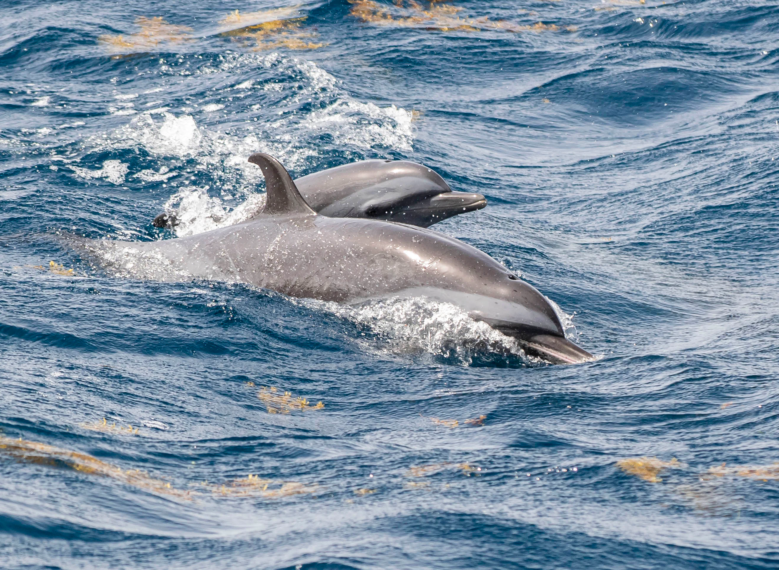
Two dolphins swimming near the surface of choppy blue ocean water.
A pod of dolphins swimming in the marine waters of Sanctuaire Agoa.

Sanctuaire Agoa history and protected-area timeline

The initiative that became Sanctuaire Agoa began in September 2003, when formal discussions started about creating a sanctuary for marine mammals in the Exclusive Economic Zone of the French Antilles. The project was driven by the Eastern Caribbean Coalition for Environmental Awareness (ECCEA) and the NGO Association Évasion Tropicale, supported later by SEPANMAR in Martinique and Breach in Guadeloupe. France formally proposed the sanctuary at the 2006 International Whaling Commission meeting in Saint Kitts and Nevis.

In 2007, the project was placed under the joint coordination of the regional environmental directorates of Martinique and Guadeloupe. The name "Agoa" was adopted in 2009, and the sanctuary was officially declared on 5 October 2010 during the 14th intergovernmental meeting of the Cartagena Convention and the 6th Conference of Parties to its SPAW Protocol, held in Montego Bay, Jamaica. The declaration was made by the French government through the Vice-President of the Agence des aires marines protégées.

Two years later, on 25 October 2012, the sanctuary received broader Caribbean recognition when it was listed as a Specially Protected Area under the SPAW Protocol. Since its creation, Agoa has hosted aerial and boat-based scientific campaigns, most notably a 2008 aerial survey that produced the first comprehensive inventory of marine mammals, ships, fishing activity, and marine debris across the entire area. The sanctuary's origins therefore combine political commitment, regional cooperation, and a strong scientific foundation.

Sanctuaire Agoa landscape and geographic character

The sanctuary is a vast maritime space rather than a terrestrial landscape, defined by the tropical and subtropical waters of the eastern Caribbean Sea. It surrounds the volcanic island arcs of the Lesser Antilles, including the mountainous islands of Guadeloupe and Martinique, the smaller limestone islands of Saint-Martin and Saint-Barthélemy, and the deeper offshore waters that extend west toward the Atlantic.

The marine environment within Agoa is shaped by the continental shelf drop-offs typical of the Caribbean, with both coastal zones and deeper pelagic waters. The islands themselves offer varied coastlines of cliffs, bays, mangroves, and reef-fringed shores. The boundary limit drawn in the 1970s between Guadeloupe and Martinique gave the sanctuary a recognisable shape that follows geographic and jurisdictional lines rather than ecological ones.

The pelagic waters inside the sanctuary support a wide range of bathymetric conditions, from shallow reef environments near the islands to deep ocean trenches offshore. This mix of underwater topography creates feeding, breeding, and migration corridors used by marine mammals that move seasonally through the Lesser Antilles.

Sanctuaire Agoa ecosystems, habitats, and plant life

The ecosystem protected by Sanctuaire Agoa is essentially pelagic and coastal Caribbean marine habitat. It includes warm tropical waters, coral reef ecosystems along the islands, deep offshore oceanic zones, and transitional habitats where coastal and oceanic species overlap. These waters are rich in plankton, small pelagic fish, and squid that form the basis of the food web supporting large marine mammals.

The sanctuary's marine environment includes seagrass beds, mangrove fringes along the coasts, and coral formations around the volcanic and limestone islands of the Antilles. The combination of islands and open ocean produces conditions favorable for biodiversity, with both resident and migratory species using the area throughout the year.

Aerial surveys carried out by the Agence des aires marines protégées in 2008 confirmed significant biodiversity, documenting a wide range of marine mammals alongside seabirds and marine reptiles. The sanctuary's ecological value is closely tied to its geographic position at the interface between the Caribbean Sea and the wider Atlantic, a region that functions as both a seasonal feeding ground and a corridor for trans-oceanic movements.

Sanctuaire Agoa wildlife and species highlights

The wildlife focus of Sanctuaire Agoa is its marine mammal fauna, with cetaceans forming the central conservation concern. Humpback whales pass through the area seasonally, attracted by the warm tropical waters for breeding and calving. Sperm whales are permanent residents in the deep waters offshore, while several species of beaked whales, including rare mesoplodonts, are documented in the deeper zones. Dolphins are abundant throughout the sanctuary, including pantropical spotted dolphins, which are strongly associated with the Agoa image and emblem.

Other marine mammals recorded in the sanctuary include smaller cetaceans and species that move between the waters of different Caribbean states. Observations have also been made of marine reptiles such as sea turtles and seabirds, although these are not the primary conservation target. Local networks of photo-identification specialists, including Caribwhale and ECCN partners, have contributed extensive visual records of individuals across the area.

The presence of whales, dolphins, and related species is the sanctuary's defining wildlife feature, and it underpins Agoa's role as a platform for scientific monitoring, citizen science, and the development of responsible ecotourism.

Sanctuaire Agoa conservation status and protection priorities

Sanctuaire Agoa is a conservation instrument designed to address the multiple threats facing marine mammals in the Caribbean. Although commercial whaling is no longer practiced in French waters, the sanctuary's creation responds to modern anthropogenic pressures including bycatch in fisheries, vessel collisions, ocean noise, chemical pollution, marine debris, and the long-term effects of climate change on habitat and prey availability.

The sanctuary operates within a layered legal and institutional framework. Internationally, it is recognized under the International Whaling Commission and the SPAW Protocol of the Cartagena Convention, while nationally it relies on the 1 July 2011 French decree that protects marine mammals across the national territory and Exclusive Economic Zone. The 2008 aerial survey created a baseline reference for future monitoring, and subsequent systematic campaigns have been used to track seasonal presence and identify critical habitats.

Agoa also plays an important role in regional conservation diplomacy, supporting the Wider Caribbean Marine Mammal Conservation Action Plan and encouraging neighboring states to adopt similar protections. Many large cetacean populations remain below ten percent of their historical pre-industrial levels, and several species remain listed by the IUCN and CITES, making the sanctuary's protective, scientific, and awareness-raising work essential to long-term recovery.

Sanctuaire Agoa cultural meaning and human context

The name Sanctuaire Agoa is drawn directly from Caribbean indigenous mythology. "Maï d'Agoa" is the mother of the spirit of waters in the mythology of the Amerindian peoples of the region, embedding the sanctuary within the ancestral cultural landscape of the Antilles. This reference gives the protected area an identity that connects marine conservation to local heritage rather than framing it as an imported European environmental concept.

Socially, the sanctuary has been shaped by close collaboration between French governmental bodies and Caribbean NGOs, scientists, fishers, and local communities. The recognition of traditional and indigenous perspectives is part of the broader narrative of how the French Antilles relate to the sea, and the sanctuary serves as a vehicle for raising awareness of Caribbean marine heritage as a shared natural legacy.

Top sights and standout views in Sanctuaire Agoa

The most distinctive feature of Sanctuaire Agoa is its unusual combination of size and focus: it covers the entire Exclusive Economic Zone of the French Antilles but concentrates specifically on marine mammals rather than ecosystems in general. This makes it one of the most targeted large-scale marine mammal protections in the world.

Another highlight is the sanctuary's role as a hub of Caribbean scientific cooperation. Through joint campaigns with the Caribbean Netherlands, Anguilla, the Dominican Republic, and partners in the United States, Agoa has helped build one of the more active networks of marine mammal observation in the Lesser Antilles.

Finally, the sanctuary stands out as a symbol of French engagement in ocean conservation. Its formal recognition by the International Whaling Commission places it alongside only two other sanctuaries worldwide, giving it an international profile that goes well beyond its regional ecological footprint.

Best time to visit Sanctuaire Agoa

Sanctuaire Agoa is a marine sanctuary, meaning its visual and biological character shifts with the seasons rather than with terrestrial weather cycles. The most recognizable seasonal phenomenon is the arrival of humpback whales in the warm Caribbean waters, with peak presence typically occurring during the cooler months of the Northern Hemisphere winter. Outside this period, the sanctuary remains active with resident dolphins, sperm whales, and other species that can be observed year-round.

Sea conditions in the Caribbean are generally favorable for boat-based excursions throughout most of the year, but weather windows are typically more reliable outside the main Atlantic hurricane season that affects the Lesser Antilles. The seasonal rhythm of marine life, rather than calendar logistics, is the primary driver of an interesting visit.
Monthly climate preview

Long-term representative point measurements tracking monthly temperature and precipitation cycles

Sanctuaire Agoa Climate Normals, Annual Temperature and Precipitation Rhythm

Representative coordinate records show monthly mean temperatures ranging from 25.72 to 28.19 degrees Celsius alongside varying daily precipitation rates across the annual cycle. Detailed monthly breakdowns provide deeper insight into long-term baseline averages and multi-month environmental patterns.
Annual mean27 °C
26 °C28 °C
Jan26°
Feb26°
Mar26°
Apr26°
May27°
Jun28°
Jul28°
Aug28°
Sep28°
Oct28°
Nov27°
Dec27°
Warmest month
September

28.2 °C

Coolest month
February

25.7 °C

Wettest month
September

5.2 mm/day

Driest month
February

1.4 mm/day

Park location guide

Geography guide, regional context, and park location map for Sanctuaire Agoa

Sanctuaire Agoa park geography, regions, and map view in France

Understand where Sanctuaire Agoa sits in France through a broader geographic reading of the surrounding landscape, nearby location context, and its mapped position within the national park landscape.

How Sanctuaire Agoa fits into France

France is a unitary semi-presidential republic and one of the world's largest economies. It borders Belgium, Luxembourg, Germany, Switzerland, Italy, Monaco, Andorra, and Spain, with a maritime border to the United Kingdom. The country is known for its cultural influence, art, cuisine, and political history spanning centuries.

Wider geography shaping Sanctuaire Agoa in France

France is located in Western Europe. Metropolitan France extends from the Rhine to the Atlantic Ocean and from the Mediterranean Sea to the English Channel and North Sea. The country borders Belgium, Luxembourg, Germany, Switzerland, Italy, Monaco, Andorra, Spain, and has a maritime border with the United Kingdom.

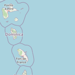
Map view of Sanctuaire Agoa

Use this park location map to pinpoint Sanctuaire Agoa in France, understand its exact geographic position, and read its mapped placement within the surrounding landscape more clearly.

Pigeon | © OpenStreetMap contributors
Recorded earthquake history

Review the Historical Earthquake Catalogue for Sanctuaire Agoa

Access the documented history of seismic events associated by distance with the marine landscape of Sanctuaire Agoa. This MoriAtlas collection provides a transparent view of historical earthquake data, including event magnitude and depth, for those exploring the regional geography of the French Antilles.

Sanctuaire Agoa Earthquake Records

Catalogued events

2,193 events

Strongest magnitude

Magnitude 7.4

Most recent event

Aug 23, 2026

This history includes earthquakes recorded inside the park or within 50 km of its borders

Visualizing the protected pelagic habitats and marine environments of the French Antilles

Sanctuaire Agoa Photos and Marine Landscape Scenery

Visual documentation reveals the expansive tropical marine habitats and offshore topography that define the protected waters of Sanctuaire Agoa. Photographic records provide clear reference material for studying the marine mammal corridors and island ecosystems of the Lesser Antilles.

Two dolphins swimming near the surface of choppy blue ocean water.

Park atlas

Compare marine protected landscapes and surrounding Caribbean conservation zones

Other Parks Near Sanctuaire Agoa and Regional Protected Areas

Browse marine protected areas and regional reserves connected to the broader geography surrounding Sanctuaire Agoa. Exploring related conservation zones provides deeper context into pelagic habitats and regional wildlife corridors across the Lesser Antilles.
Watercolor painting of mountains, a lake, and green hills
National parkGuadeloupe
Park boundaries overlap#1 closest

Northwest

Guadeloupe National Park: Volcanic Rainforest and Protected Landscape Identity

Explore mapped boundaries and regional geography.

Guadeloupe National Park stands as a significant protected landscape, primarily defined by the dramatic volcanic terrain of Basse-Terre. This atlas entry focuses on the park's vital role in preserving one of the Caribbean's most extensive tropical rainforest ecosystems, centered around the active La Soufrière volcano. Understand its mapped boundaries, unique geographic setting within the Lesser Antilles, and its importance as a national park and UNESCO biosphere reserve.

Area
173 km²
Established
1989
IUCN
II
Relief
Mountain
Nature reserveMartinique
Mapped location lies within the park boundary#2 closest

West

Réserve naturelle régionale marine du Prêcheur - Albert Falco: Martinique Marine Protected Area Atlas

Coastal habitat protection and seabed geography in the French Caribbean.

This protected area encompasses over 600 hectares of seabed and water column along the Le Prêcheur coastline. It represents a significant conservation effort within the Lesser Antilles, preserving coral reefs and nearshore marine structures situated beneath the volcanic terrain of northern Martinique. Named after the oceanographer Albert Falco, the reserve maintains a distinct connection to the maritime heritage of the island.

Area
6.03 km²
Established
2014
IUCN
IV
Scope
Marine
A soft, artistic watercolor painting of a calm landscape with rolling green hills, lush vegetation, and a winding waterway, presented on a white background.
Nature reserveMartinique
About 0.2 km away#3 closest

Southwest

Réserve naturelle nationale de la presqu'île de la Caravelle: Geography and Protected Area Atlas

Explore ancient Atlantic coastal landscapes and protected habitats in Martinique.

Located on the eastern tip of Martinique, the Réserve naturelle nationale de la presqu'île de la Caravelle stands as a critical protected landscape. This atlas entry details its unique geological history, dating back twenty-five million years, alongside its complex network of mangrove-fringed bays, dramatic Atlantic cliffs, and specialized island ecosystems. It serves as an essential reference for understanding the distinctive biogeography of the French Caribbean.

Area
3.88 km²
Established
1976
IUCN
IV
Visitors
400K annual
Marine protected areaSint Maarten
About 5.2 km away#4 closest

Northwest

Man of War Shoal National Marine Park: Mapping the Protected Waters of Sint Maarten

A vital marine protected area on the edge of the Anguilla Bank.

Man of War Shoal National Marine Park represents a significant Caribbean marine sanctuary covering 3,100 hectares of coastal sea. The area is defined by its intact patch reefs, submerged 19th-century shipwrecks, and varied seabed topography, including vertical walls and expansive seagrass fields that support diverse pelagic and reef-dwelling marine life.

Area
31 km²
Established
2010
Relief
Lowland
Access
Easy access
National parkDominica
About 17 km away#5 closest

Northwest

Cabrits National Park: Protected Landscape and Geographic Context in Dominica

Explore Dominica's volcanic terrain and mapped protected areas.

Delve into the protected landscape of Cabrits National Park, a key component of Dominica's natural heritage. This entry provides an atlas-focused view of the park, detailing its geographic setting and mapped boundaries within the island nation. Understand how Cabrits National Park contributes to the regional geography of the Lesser Antilles and appreciate its significance as a protected natural area for structured discovery.

Area
5.3 km²
Established
1986
IUCN
II
Relief
Upland
Marine protected areaSint Eustatius
21 km away#6 closest

Northwest

Sint Eustatius National Marine Park: Protected Marine Geography and Atlas

Volcanic foundations, shipwreck reefs, and marine conservation zones

Sint Eustatius National Marine Park protects a diverse Caribbean marine ecosystem defined by its volcanic origins. The area features reefs growing on submerged lava flows and colonial shipwrecks, integrated with designated no-take reserves that safeguard critical sea turtle nesting sites and migratory corridors for cetaceans.

Area
27.5 km²
Established
1996
Climate
Tropical
Access
Access unknown
National parkDominica
23 km away#7 closest

Northwest

Morne Trois Pitons National Park: Dominica's Volcanic Protected Area Atlas

Explore its unique geothermal terrain and mapped natural boundaries.

Morne Trois Pitons National Park represents a core protected area within Dominica, renowned for its dramatic volcanic landscapes and rich geothermal activity. This national park features steep volcanic cones, deep canyons, and diverse terrain shaped by intense geological forces. The park's mapped boundaries encompass unique natural wonders, offering a focused study of volcanic geography and protected ecosystems. Discover the contours of this significant Caribbean landscape and its inherent natural value.

Area
68.57 km²
Established
1975
IUCN
II
Relief
Mountain
National parkDominica
About 27 km away#8 closest

Northwest

Morne Diablotin National Park: Dominica National Park Geographic Atlas Exploration

Mapped protected areas and regional landscape context.

Morne Diablotin National Park serves as a vital national park within Dominica, offering specific insights into its protected terrain and geographic setting. Explore its mapped boundaries and understand its role as a distinct natural landscape within the island's atlas, providing focused discovery for those interested in protected areas and their regional context.

Area
33.35 km²
Established
2000
Relief
Mountain
Climate
Tropical

Common questions about visiting, size, designation, and location context for Sanctuaire Agoa

Sanctuaire Agoa FAQs for park facts, access, geography, and protected area context

Find quick answers about Sanctuaire Agoa, including protected-area facts, park geography, trail and visitor context, and how the park fits into its surrounding country and regional landscape.
MoriAtlas Explorer

Continue Your Protected Areas Search Across the Global Atlas

Deepen your exploration by continuing the structured search for national parks and protected areas worldwide. Utilize the comprehensive filtering capabilities to compare different conservation landscapes and refine your understanding of global park geography. Discover more about the distribution and characteristics of protected natural areas.

Global natural geography