

Mori Atlas logo
Biosphere reserveIslas Marías

A detailed look at the volcanic topography, endemic ecosystems, and isolated marine boundaries defining these Pacific islands.

Islas Marías Biosphere Reserve: Mapping the Protected Pacific Archipelago of Nayarit, Mexico

(Reserva de la Biosfera Islas Marias)

The Islas Marías form a distinctive Pacific archipelago located roughly 112 kilometers off the coast of Nayarit, Mexico. Spanning nearly 245 square kilometers, the biosphere reserve encompasses four main islands and several smaller islets that display varied landscapes from rugged volcanic hills to low-lying coastal plains. This protected area serves as a critical refuge for endemic species and rich marine habitats, offering a clear geographic perspective on one of Mexico's most isolated and ecologically significant island territories.

Pacific islandsbiosphere reserveUNESCO protected areaMexican islandssubtropical climateisland archipelago

Islas Marías

Biosphere reserve

Park overview

Structured park overview, official facts, and landscape profile for Islas Marias

Islas Marias park facts, protected area profile, and essential visitor context

Review the core facts for Islas Marias, including designation, size, terrain, visitor scale, habitats, and operating context in one park-focused overview.

About Islas Marias

The Islas Marias occupy a singular place among Mexico's protected natural areas because they are both an isolated Pacific archipelago and a former federal penal colony. They lie about 112 kilometers offshore from Nayarit, far enough from the mainland to have developed distinct ecological conditions yet close enough to have once shared a land connection in the distant past. This combination of isolation and historical proximity is central to the archipelago's biological identity and is what makes its endemic species particularly important to conservation science.

Geographically, the archipelago is composed of four principal islands, Maria Madre, Maria Magdalena, Maria Cleofas, and San Juanito, together with several smaller islets. Maria Madre is by far the largest at roughly 145 square kilometers and the only island with permanent human settlement, centered on the locality of Puerto Balleto. The islands vary dramatically in their topography: Maria Madre rises sharply with cliffs and forested slopes reaching Punta Rocallosa, while San Juanito is low and gently contoured, barely exceeding twelve meters in elevation. Their combined length stretches approximately 80 kilometers.

Ecologically, the islands represent a subtropical Pacific environment with abundant summer rainfall and a mosaic of habitats ranging from coastal mangroves and cactaceous shrublands to interior forests of mesquite, guayacan, ceiba, and tropical hardwoods. The waters around the archipelago host a rich marine fauna, including sharks, large fish schools, and seasonal visits by gray whales. The biological distinctiveness of the islands was formally recognized in 2010, when UNESCO declared the archipelago a biosphere reserve under Mexican federal protection.

Since the closure of the federal penal colony in 2019, the islands have increasingly been repositioned as a model of conservation-led repopulation and controlled ecological visitation, with tourism focused on nature appreciation and academic study rather than mass tourism. The opening of the Islas Marias Tourist Center on Maria Madre in late 2022 signaled a new phase for the archipelago, balancing access with the preservation of a fragile island ecosystem.

Quick facts and research context for Islas Marias

The Islas Marias are an archipelago of four main islands and several islets in the Pacific Ocean, belonging administratively to Nayarit but considered federal territory. Their combined area is about 244.97 square kilometers, with the largest island, Maria Madre, dominating roughly 145 square kilometers of that total. The climate is subtropical with abundant summer rainfall, and the highest point, Punta Rocallosa on Maria Madre, reaches 616 meters in elevation.

The archipelago was first recorded by Spanish explorers in 1532 and was used as a federal penal colony from 1905 until the prison was dissolved by decree in 2019. In 2010, UNESCO designated the islands as a biosphere reserve, and today they are administered as a protected natural area. Only Maria Madre remains populated, with Puerto Balleto as the main settlement, while the other islands are kept largely uninhabited and under protection.

Protection and recognition

Explore the documented designation history and mixed protection scope of Islas Marías.

Islas Marías Protection Status and Official International Recognition Data

Islas Marías maintains a designated protection status established in 2010 alongside official international recognition from UNESCO as a biosphere reserve. Structured records compile the management scope and historical conservation data associated with this protected archipelago.

International recognition

Protection details

Protection scope
Mixed
Designated year
2010
Transboundary protection
No
Core area
148.44 km²
Buffer area
1,386.77 km²
Park context

Deeper park guide and search-rich context for Islas Marias

Islas Marias history, landscape, wildlife, and travel context

Explore Islas Marias through its history, landscape character, ecosystems, wildlife, conservation priorities, cultural context, and seasonal travel timing in a structured park guide built for atlas discovery and search intent.

Why Islas Marias stands out

The Islas Marias are best known as a UNESCO-designated biosphere reserve encompassing four Pacific islands off Nayarit, Mexico, and for their unusual combination of penal colony history and ecological significance. They support a notable number of endemic species, including the Marias rabbit, the Tres Marias raccoon, the Marias Islands mouse, and the threatened gray mouse opossum, reflecting a historic land bridge with the mainland. The archipelago is also distinguished by its isolation, subtropical climate, rugged terrain capped by Punta Rocallosa on Maria Madre, and a surrounding marine environment where gray whales, sharks, large fish schools, and mollusks have been observed. Its transition from a closed penal territory to a biosphere reserve managed for conservation and low-impact tourism gives it a distinctive profile among Mexican protected natural areas.
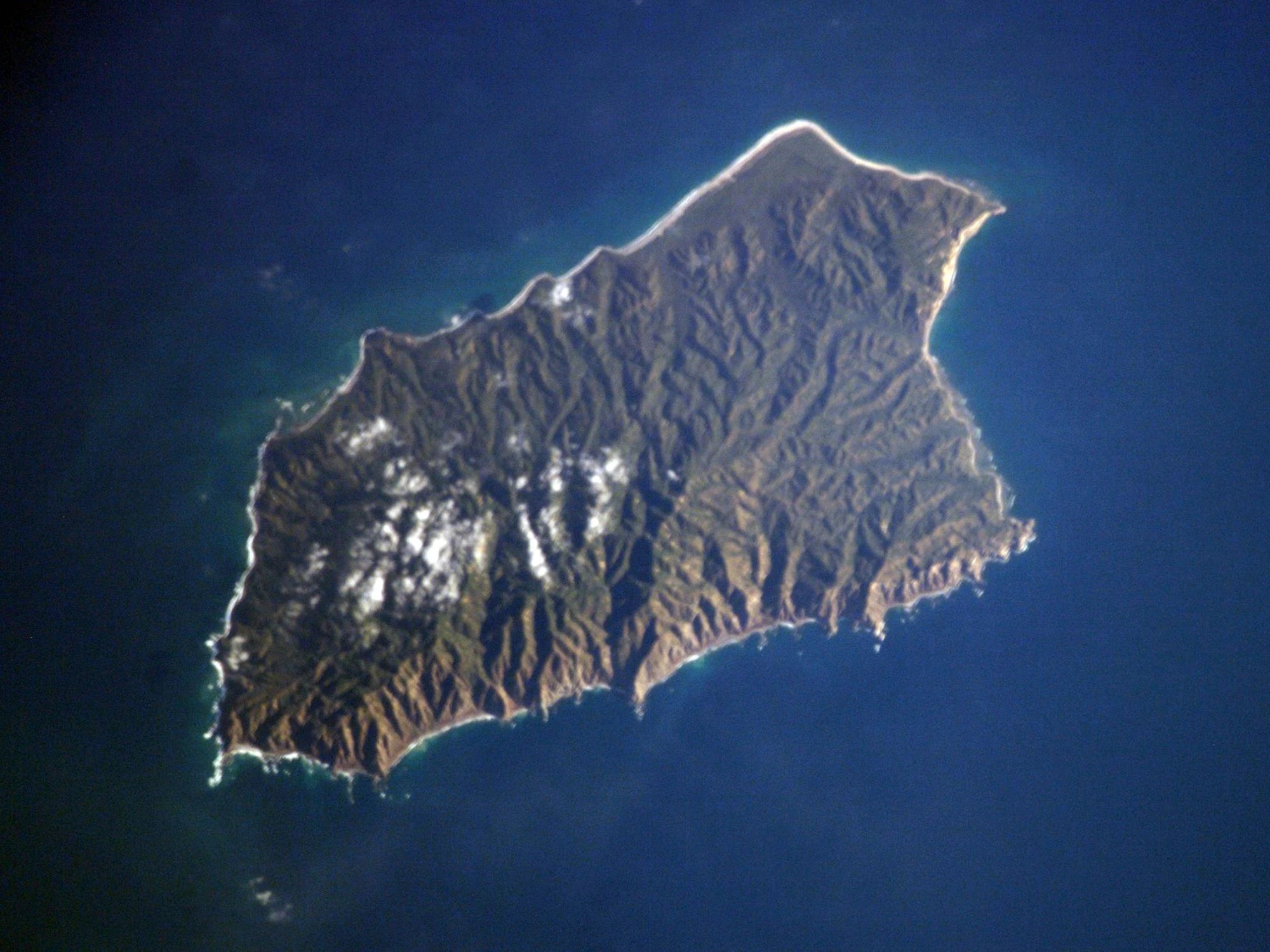
Satellite photograph from space showing the rugged, green terrain of Maria Magdalena Island surrounded by deep blue Pacific Ocean waters.
An orbital view of Maria Magdalena Island in the Islas Marías archipelago.

Islas Marias history and protected-area timeline

The Islas Marias were first sighted by Europeans in 1532, when an expedition organized by Hernan Cortes and commanded by his cousin Diego Hurtado de Mendoza departed the Pacific coast in search of new lands and a rumored northern strait connecting the Pacific and Atlantic oceans. The expedition, sailing from Oaxaca and coasting past Colima, Jalisco, and Nayarit, reached the archipelago and named the islands the Magdalenas. Around the same period, a separate expedition led on behalf of conquistador Nuno de Guzman also reached the islands, which he called the Islas de la Concepcion. The Royal Audiencia of New Spain ultimately granted formal recognition of the discovery to Hurtado de Mendoza, and the islands fell within the colonial administrative sphere, though they received little sustained attention during the viceregal era.

In the nineteenth century, the archipelago's ownership shifted between private hands and the Mexican state. The 1836 Treaty of Peace and Friendship between Mexico and Spain formally recognized Mexican sovereignty over the islands. Contracts to exploit the islands' natural resources, including salt deposits, were issued and later annulled, passing through figures such as General Jose Lopez Uraga before the federal government reacquired the territory in 1905.

The most defining chapter of the islands' modern history began in 1905 with the establishment of the Colonia Penal Federal Islas Marias on Maria Madre. The colony functioned as a low-security federal prison where inmates lived with their families, worked in agricultural and livestock camps, and gradually contributed to the development of Puerto Balleto, including schools, a hospital, a library, a pier, and paved streets. Federal management and direction by figures such as Brigadier General Rafael M. Pedrajo shaped the settlement into an organized community without walls.

In March 2019, the Mexican government dissolved the penal colony by decree, ending more than a century of imprisonment on the islands. The archipelago's prior declaration as a UNESCO biosphere reserve in 2010 set the framework for its new identity as a protected natural area. In December 2022, the government inaugurated the Islas Marias Tourist Center on Maria Madre, opening the islands to a controlled form of nature-based and academic tourism departing from ports in Mazatlan and San Blas.

Islas Marias landscape and geographic character

The Islas Marias form a roughly 80-kilometer-long Pacific archipelago with a maximum width of around 20 kilometers, dominated by four distinct islands whose terrain varies from steep volcanic hills to low, flat islets. Maria Madre, the largest island, features the archipelago's most dramatic topography, with elevations rising to Punta Rocallosa near 616 meters, marked by cliffs, ravines, and forested slopes. Its coastline alternates between sheltered coves, small bays, and exposed rocky points, creating a varied setting that supports both terrestrial and marine habitats.

Maria Magdalena presents a similarly rugged profile, with interior elevations reaching about 450 meters and subtropical vegetation covering most of its surface. Maria Cleofas, smaller and semicircular in shape, opens into a broad southern inlet and reaches only around 150 meters at its highest point, giving it a softer, more enclosed character. San Juanito, the smallest of the four main islands, is a low, comparatively flat landmass barely exceeding 12 meters in elevation, accompanied offshore by Piedra el Morro, a small rock islet about six kilometers to the southwest.

The surrounding waters extend the landscape well beyond the shorelines. Deep Pacific channels flank the islands, and the marine environment includes areas where gray whales have been observed, as well as habitats favored by sharks and large schools of fish. The visual impression of the archipelago from the sea is one of isolated green hills rising abruptly from blue ocean, reinforcing the impression of a remote and well-defined natural system.
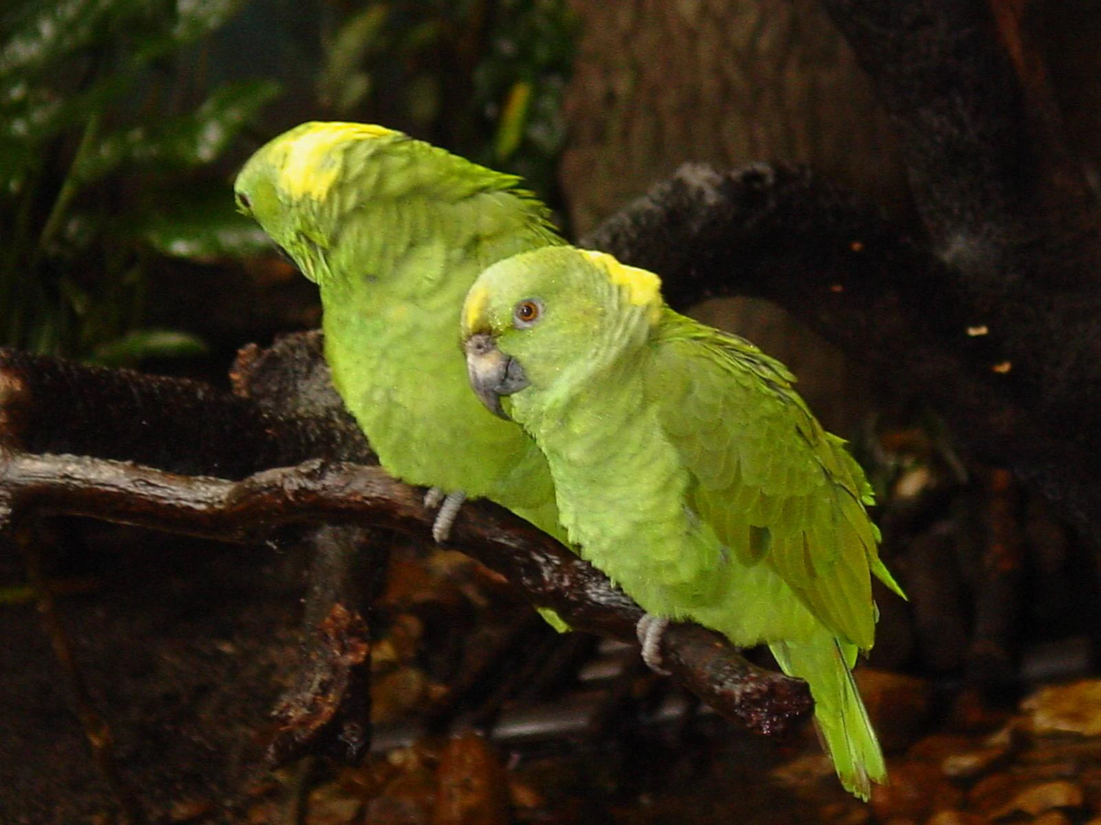
Two bright green parrots with yellow crowns perched side by side on a dark wooden branch.
A pair of Amazon parrots perched on a branch, representative of the avian wildlife found within the archipelago.

Islas Marias ecosystems, habitats, and plant life

The natural environment of the Islas Marias reflects their long isolation from the Mexican mainland and their subtropical Pacific climate, which is characterized by warm temperatures and abundant rainfall concentrated in the summer months. Because of this combination, the islands support vegetation communities that blend elements of tropical dry forest, coastal scrub, and cactaceous shrubland. Common plant formations include stands of mesquite, guayacan, ceiba, and palm species, along with coastal mangroves, wild plantains, and dense thickets of cardon cacti, organ cacti, prickly pears, and garambullos.

The ecological value of the archipelago lies in the presence of endemic species that survive only on these islands, as well as in the relative health of habitats that have remained lightly impacted by human activity outside of Maria Madre. The evidence of past biogeographic connections with the mainland, through what was once a land bridge, is reflected in the islands' distinctive mammal and reptile fauna. Subtropical forest cover extends across most of the islands' interior slopes, while coastal and mangrove zones form a critical transition between terrestrial and marine ecosystems.

While Maria Madre carries the heaviest footprint of human settlement and introduced species, the other main islands remain comparatively pristine and provide some of the most undisturbed habitats in the archipelago. This gradient of ecological condition across the four islands has been important to the biosphere reserve's conservation strategy, helping to balance protection, research, and limited human presence.

Islas Marias wildlife and species highlights

The Islas Marias support a distinctive island fauna shaped by long isolation and a historic connection with the Mexican mainland. The archipelago is notable for several endemic mammals, including the Marias rabbit, the Tres Marias raccoon, the Marias Islands mouse, and the threatened gray mouse opossum. These species represent a high-priority component of the islands' conservation value, alongside native reptiles such as iguanas and chameleon-like lizards, and a wide variety of snakes, including venomous species native to the islands.

The birdlife of the archipelago is similarly rich, with resident parrots, mockingbirds, turkey vultures, opossums seen at dusk, and seabirds such as boobies frequenting the cliffs and shores. Bats are also part of the island fauna, occupying caves and shaded interior habitats. Insects are abundant and diverse, with notable populations of beetles, butterflies, grasshoppers, bees, wasps, and mosquitoes. Introduced animal species, including goats, cats, black rats, horses, cattle, sheep, roosters, and several domestic pigeon and sparrow species, have become part of the islands' fauna over time, though their impact on native wildlife is a recognized concern.

The surrounding marine environment extends the wildlife profile well beyond land. Gray whales have been sighted near the archipelago, and the waters are known for their populations of sharks, large fish schools, and a diverse mollusk community. This combination of endemic terrestrial species and rich marine fauna is central to the biosphere reserve's identity.

Islas Marias conservation status and protection priorities

The Islas Marias have been formally recognized as a biosphere reserve by UNESCO since 2010, marking them as one of Mexico's key island protected areas. Their conservation value rests on the high level of endemism among terrestrial species, the islands' isolation from mainland disturbances, and the relative integrity of marine and coastal habitats surrounding the archipelago. Federal environmental authorities oversee the islands under the broader national system of protected natural areas, with particular attention to the fragility of island ecosystems and their limited capacity to absorb human impact.

The closure of the federal penal colony in 2019 marked a major shift in how the islands are managed. The transition away from inmate labor and settlement-oriented activities has allowed conservation to become the dominant framework for the archipelago, and the administration has emphasized repopulation under principles of ecological protection and environmental conservation. The opening of the Islas Marias Tourist Center in late 2022 reflects a deliberate model of nature-focused and academic tourism rather than mass visitation, designed to generate ecological awareness without compromising the islands' fragile ecosystems.

Continued protection of endemic species, control of invasive species, and careful regulation of tourism access remain central concerns. The islands constitute both a refuge for island-endemic wildlife and a laboratory for conservation practice in a setting that combines a unique ecological identity with a complex recent social history.

Islas Marias cultural meaning and human context

The cultural profile of the Islas Marias is closely linked to their long history as a federal penal colony and to the communities that lived there under that system. From 1905 to 2019, generations of inmates, their families, and prison staff lived on Maria Madre, shaping the settlement of Puerto Balleto and its associated campamentos such as Rehilete, Aserradero, Bugambilias, and Laguna del Toro. The colony generated its own social fabric, including schools, a hospital, a library, and even a local digital television channel, leaving a distinctive imprint on the archipelago's human geography.

The islands also occupy a small but recognizable place in Mexican popular culture. The 1950s film Las Islas Marias, directed by Emilio Fernandez and featuring Pedro Infante, dramatized the lives of inmates and helped embed the archipelago in the public imagination. Popular television comedy, including episodes of El Chavo del 8, referenced the islands as a synonym for remote confinement, reinforcing their place in everyday Mexican cultural references.

Following the closure of the penal colony, the cultural identity of the islands is being redefined around ecological stewardship, scientific research, and a measured tourism experience. The move reflects a broader shift in how Mexico frames remote territories with difficult histories, emphasizing heritage, nature, and education rather than incarceration.

Top sights and standout views in Islas Marias

The Islas Marias stand out for the combination of UNESCO biosphere reserve status, endemic island wildlife, and a layered history stretching from 1532 Spanish exploration through more than a century of federal penal use to a present focused on conservation. The archipelago's scale, four main islands with markedly different profiles and a combined area near 245 square kilometers, makes it one of the most distinctive island territories in Mexican Pacific waters.

For visitors, researchers, and conservation planners, the most compelling features include the endemic Marias rabbit, Tres Marias raccoon, and Marias Islands mouse, the dramatic terrain of Maria Madre rising to Punta Rocallosa, the rich marine life with seasonal gray whale sightings, and the post-2019 transformation of the islands into a controlled nature-based destination anchored by the Centro Turistico Islas Marias on Maria Madre.

Best time to visit Islas Marias

The Islas Marias have a subtropical climate with abundant rainfall concentrated in the summer months, which shapes both the vegetation cycle and the marine conditions around the archipelago. The drier months, generally outside the peak summer rainy period, tend to offer more stable conditions for boat travel, clearer visibility for coastal scenery, and easier movement between sites on Maria Madre. Wildlife observation can vary seasonally, with calmer seas often favoring marine sightings such as whale approach corridors and shore-based birdwatching.

Because the islands are visited primarily through organized, weekend departures from Mazatlan and San Blas, the practical window for a trip is closely tied to scheduled maritime service rather than purely to natural conditions. Choosing a period with milder weather generally offers a more rewarding mix of terrestrial exploration and marine scenery, while the rainy season highlights the lushness of the islands' vegetation and the intensity of their tropical character.

Monthly climate preview

Measured annual temperature and monthly precipitation patterns for Islas Marías

Islas Marías Climate Normals and Long-Term Weather by Month

Representative coordinates record sustained monthly temperature variation alongside distinct precipitation rhythms across the sampled elevation. Examining the complete twelve-month climatology profile reveals precise shifts in long-term averages for Islas Marías.
Annual mean26 °C
23 °C29 °C
Jan23°
Feb23°
Mar23°
Apr24°
May26°
Jun27°
Jul28°
Aug29°
Sep29°
Oct29°
Nov27°
Dec25°
Warmest month
August

28.8 °C

Coolest month
March

22.9 °C

Wettest month
August

10.6 mm/day

Driest month
April

0.1 mm/day

Park location guide

Geography guide, regional context, and park location map for Islas Marias

Islas Marias park geography, regions, and map view in Mexico

Understand where Islas Marias sits in Mexico through a broader geographic reading of the surrounding landscape, nearby location context, and its mapped position within the national park landscape.

How Islas Marias fits into Mexico

Mexico, officially the United Mexican States, is a country in North America spanning the Sierra Madre mountain ranges, coastal plains, and tropical regions. It borders the United States to the north, Guatemala and Belize to the southeast, and has coastlines along the Pacific Ocean, Gulf of Mexico, and Caribbean Sea. With a population exceeding 130 million, Mexico is home to one of the world's most significant concentrations of Indigenous languages alongside Spanish.

Wider geography shaping Islas Marias in Mexico

Mexico occupies a land area of 1,972,550 km2, making it the thirteenth-largest country in the world. The terrain is highly diverse, featuring the Sierra Madre Occidental and Sierra Madre Oriental mountain ranges, the Mexican Plateau, coastal lowlands along the Pacific and Gulf/Caribbean margins, and the Yucatan Peninsula. The country spans multiple climate zones from desert in the north to tropical rainforest in the south.

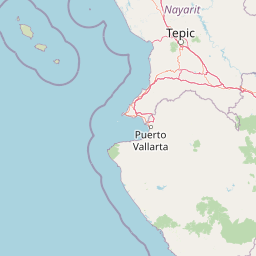
Map view of Islas Marias

Use this park location map to pinpoint Islas Marias in Mexico, understand its exact geographic position, and read its mapped placement within the surrounding landscape more clearly.

Pigeon | © OpenStreetMap contributors

Location context for Islas Marias

Nayarit

Visual reference for volcanic terrain, subtropical habitats, and island ecosystems

Islas Marías Photos and Landscape Scenery in the Pacific Biosphere Reserve

Examine detailed photographs showcasing the rugged volcanic topography and coastal habitats of the Islas Marías archipelago. Visual documentation reveals the distinct ecological character of these protected Pacific islands and their surrounding marine environment.

Satellite photograph from space showing the rugged, green terrain of Maria Magdalena Island surrounded by deep blue Pacific Ocean waters.

An overhead satellite photograph of Maria Cleofas Island surrounded by deep blue ocean water, with scattered clouds casting shadows over the island surface.

Two bright green parrots with yellow crowns perched side by side on a dark wooden branch.

Park atlas

Compare related Pacific island reserves and coastal conservation landscapes next

Explore Parks Near Islas Marías and Protected Areas in the Surrounding Region

Continue geographic discovery by comparing national parks and protected areas near Islas Marías with other regional reserves. Examining connected coastal landscapes and island territories provides a broader perspective on marine conservation and regional terrain.
National parkNayarit
About 71 km away#1 closest

Northeast

Isla Isabel National Park: Protected Island Landscape within Nayarit's Geography

Explore its mapped boundaries and distinct geography.

Isla Isabel National Park represents a crucial protected area within the broader geographic framework of Nayarit. This national park offers a focused lens for exploring a unique island landscape, its specific mapped boundaries, and its place within the regional atlas. Understanding its ecological and geographic context is key to appreciating this distinct natural landscape.

Area
1.94 km²
Established
1980
IUCN
II
National parkNayarit
About 125 km away#2 closest

Southeast

Islas Marietas National Park: National Park Protected Landscape and Geographic Context

Explore its mapped boundaries and natural terrain in Nayarit.

Discover the distinct protected landscape of Islas Marietas National Park, a vital national park situated in the Nayarit region of Mexico. This entry facilitates a detailed exploration of its mapped geography and protected area status, offering a specific focus on the park's natural terrain and its significance within the broader atlas of conservation lands. Understand the unique context provided by its location and designation for comprehensive geographic discovery.

IUCN
II
Visitors
127.4K annual
Climate
Tropical
Access
Moderate access
Biosphere reserveNayarit
About 155 km away#3 closest

East

Sierra de San Juan Biosphere Reserve: Geographic Overview and Protected Area Mapping

Volcanic terrain and forest ecosystems in Nayarit, Mexico

Explore the volcanic landforms and layered forest communities of Sierra de San Juan Biosphere Reserve. This protected area in Nayarit spans distinct ecological zones from dry coastal lowlands to mountain cloud forests, providing essential habitat and unique biodiversity at the convergence of major Mexican mountain systems.

Area
198.01 km²
Established
2003
Relief
Mountain
Scope
Terrestrial
Protected areaMexico
About 209 km away#4 closest

East

Cuenca Alimentadora del Distrito Nacional de Riego 043 Estado de Nayarit: Atlas Overview

Watershed reserve and montane forest geography

This extensive protected area spans the Sierra Madre Occidental, featuring a fragmented landscape of high mountain ridges separated by river valleys. It safeguards critical pine and oak forest ecosystems that supply the Irrigation District 043, serving as a vital natural resource hub in west-central Mexico.

Area
23,290.3 km²
Established
1949
IUCN
VI
Relief
Mountain
Wildlife reserveSinaloa
About 236 km away#5 closest

North

Meseta de Cacaxtla Flora and Fauna Protection Area: Sinaloa Protected Landscape Overview

Mapping dry forests and Pacific coastal ecosystems

Meseta de Cacaxtla Flora and Fauna Protection Area is a significant wildlife reserve in Sinaloa, characterized by its transition from an elevated inland plateau to a complex coastal fringe of mangroves and lagoons. Spanning 508 square kilometers, this protected area preserves an essential blend of arid tropical ecosystems and marine habitats along the Mexican Pacific coast, providing a clear geographic view of regional conservation efforts.

Area
508.62 km²
Established
2000
IUCN
VI
Relief
Lowland
Regional parkSinaloa
About 273 km away#6 closest

North

Ceuta Regional Park: Coastal Geography and Protected Nesting Habitats in Sinaloa

Coastal protection and agricultural valley landscape analysis.

Ceuta Regional Park stands as a key protected area on the Sinaloa coast of Mexico, noted for its long-standing sea turtle conservation initiatives and importance to migratory shorebirds. The park geography spans low-lying coastal plains and beach environments, framed by the agricultural heart of the Elota municipality. This entry provides a structural overview of the terrain, boundaries, and ecological context defining this coastal reserve.

Area
15 km²
Established
2002
Relief
Lowland
Access
Access unknown
Wildlife reserveJalisco
About 285 km away#7 closest

Southeast

Sierra de Quila: Protected Mountain Geography and Forested Wildlife Reserve in Western Jalisco

Mapped terrain, watershed boundaries, and high-altitude forest ecosystems

Sierra de Quila stands as a prominent protected mountain range in western Jalisco, offering a unique mosaic of pine, oak, and mesophilic cloud forests. This wildlife reserve serves as a essential natural anchor for regional biodiversity and watershed protection, with its rugged canyons and dramatic elevation changes providing a distinct geographical profile within the broader Mexican landscape.

Area
151.92 km²
Established
1982
Relief
Mountain
Climate
Temperate
A horizontal watercolor painting depicting a soft-focus landscape with rolling green hills, patches of forest, and light golden hues representing meadows or dry terrain.
Biosphere reserveJalisco
About 318 km away#8 closest

East

La Primavera Biosphere Reserve: Mapping Volcanic Landscapes and Protected Watersheds

Ecological geography and forest distribution in Jalisco, Mexico

Centering on the Sierra la Primavera volcanic complex, this biosphere reserve functions as an essential green corridor and water catchment zone. The terrain consists of a complex mosaic of vegetation types, including pine-oak forests and relict cloud forest patches across high-elevation ridges. Discover the structural role of these protected lands in moderating the climate and supporting biodiversity in the Guadalajara metropolitan region.

Area
305 km²
Established
2000
IUCN
VI
Relief
Mountain

Common questions about visiting, size, designation, and location context for Islas Marias

Islas Marias FAQs for park facts, access, geography, and protected area context

Find quick answers about Islas Marias, including protected-area facts, park geography, trail and visitor context, and how the park fits into its surrounding country and regional landscape.
MoriAtlas Explorer

Continue Your Protected Areas Search Across the Global Atlas

Deepen your exploration by continuing the structured search for national parks and protected areas worldwide. Utilize the comprehensive filtering capabilities to compare different conservation landscapes and refine your understanding of global park geography. Discover more about the distribution and characteristics of protected natural areas.

Global natural geography