Mori Atlas logo
Biosphere reserveSierra de San Juan Biosphere Reserve

Mapping the transitional forest ecosystems and stratovolcano boundaries in western Mexico

Sierra de San Juan Biosphere Reserve: Volcanic Landscapes and Regional Geography in Nayarit

The Sierra de San Juan Biosphere Reserve protects a significant volcanic landscape within the state of Nayarit. Positioned at the western edge of the Trans-Mexican Volcanic Belt, this reserve encompasses twin stratovolcanoes and deep elevation gradients that compress dry forests, pine-oak woodlands, and cloud forest zones into a compact geographic area. It serves as a vital biological corridor between the Sierra Madre Occidental and the Pacific lowlands.

biosphere reserveMexicoNayaritTrans-Mexican Volcanic Beltvolcanic landscapestratovolcano

Sierra de San Juan Biosphere Reserve

Biosphere reserve

Park overview

Structured park overview, official facts, and landscape profile for Sierra de San Juan Biosphere Reserve

Sierra de San Juan Biosphere Reserve park facts, protected area profile, and essential visitor context

Review the core facts for Sierra de San Juan Biosphere Reserve, including designation, size, terrain, visitor scale, habitats, and operating context in one park-focused overview.

About Sierra de San Juan Biosphere Reserve

The Sierra de San Juan Biosphere Reserve encompasses a substantial portion of the Sierra de San Juan, a mountain range that defines the landscape immediately southwest of Tepic, the capital of Nayarit. Although it has a total area of only about 198 square kilometers, the reserve captures an unusually complete ecological gradient because it stretches from the moist Pacific slopes in the west to the drier interior valleys in the east and rises from foothills below 1,000 meters to summits above 2,200 meters. This combination of volcanic geology, steep terrain, and proximity to the ocean gives the reserve a layered character in which vegetation, climate, and wildlife change dramatically over short horizontal distances.

Geologically, the reserve belongs to the Trans-Mexican Volcanic Belt and represents the westernmost reach of this major volcanic system. The range's two defining peaks, Cerro Alto at 2,240 meters and Volcán San Juan with its elongated, one-by-four-kilometer caldera, are stratovolcanoes whose eruptions and erosional history have shaped the steep slopes and deep ravines seen today. Volcán San Juan's caldera formed roughly 15,000 years ago in a major eruption, and the resulting landforms continue to influence drainage patterns, soils, and the distribution of vegetation across the reserve.

The climate of the Sierra de San Juan reflects its position between the Pacific Ocean and the interior valleys of Nayarit. Below about 1,600 meters, conditions are subhumid and semi-warm, with rainfall and humidity noticeably higher on the westward slopes that face the ocean. Above 1,600 meters, the climate becomes temperate subhumid, with frequent mists through much of the year and annual precipitation ranging from roughly 1,300 to 1,800 millimeters. This moisture profile allows moisture-loving plant communities such as cloud forest to persist alongside drier vegetation types that dominate the rain-shadow slopes.

From a conservation standpoint, the reserve was originally created in 1987 by the state government of Nayarit under a designation focused on conservation, ecological balance, and environmental regeneration, with most of its land held by ejidos, indigenous and community-managed agricultural commons. After careful boundary adjustments in 2003, it was elevated to the status of a Special Biosphere Reserve, modernizing its protection framework. Today, the Sierra de San Juan Biosphere Reserve is recognized as one of the most botanically diverse protected areas in Nayarit, holding an estimated 30 percent of the state's plant species within a comparatively small area.

Quick facts and research context for Sierra de San Juan Biosphere Reserve

Sierra de San Juan Biosphere Reserve lies in Nayarit state, western Mexico, directly southwest of the city of Tepic and approximately 22 kilometers inland from the Pacific Ocean. It protects a westward extension of the Trans-Mexican Volcanic Belt and covers about 198 square kilometers. The reserve was first declared by the State of Nayarit in 1987 and then redesignated as a Special Biosphere Reserve by the federal government in 2003, with boundaries adjusted to exclude heavily urbanized and cultivated areas on the drier slopes.

The landscape is dominated by two stratovolcanoes: Cerro Alto, which rises to 2,240 meters and is the older and taller of the pair, and Volcán San Juan, which has an oval caldera formed roughly 15,000 years ago. Elevation, slope orientation, and distance from the coast all strongly influence vegetation, producing a stacking of dry forests, pine and oak forests, cloud forest, and high-elevation grassland within a relatively small reserve.

Protection and recognition

Examine the terrestrial protection scope and 2003 designation timeline for this protected area.

Sierra de San Juan Biosphere Reserve Protection Status and Designation History

Terrestrial protection status for Sierra de San Juan Biosphere Reserve centers on its established 2003 designation year. Structured records outline the conservation framework and management scope governing this protected natural landscape.

Protection details

Protection scope
Terrestrial
Designated year
2003
Park context

Deeper park guide and search-rich context for Sierra de San Juan Biosphere Reserve

Sierra de San Juan Biosphere Reserve history, landscape, wildlife, and travel context

Explore Sierra de San Juan Biosphere Reserve through its history, landscape character, ecosystems, wildlife, conservation priorities, cultural context, and seasonal travel timing in a structured park guide built for atlas discovery and search intent.

Why Sierra de San Juan Biosphere Reserve stands out

The reserve is best known for its volcanic landforms, transitional forest communities, and unusually rich biodiversity within a compact area. Its twin stratovolcanoes mark the western end of the Trans-Mexican Volcanic Belt, while its elevation gradient compresses several biomes into a small footprint. The area is particularly noted for its cloud forest patches, for being a southern outlier of the Sierra Madre Occidental pine-oak forests, and for hosting many rare and locally endemic plant species, including Magnolia pacifica, alongside more than 200 bird species.
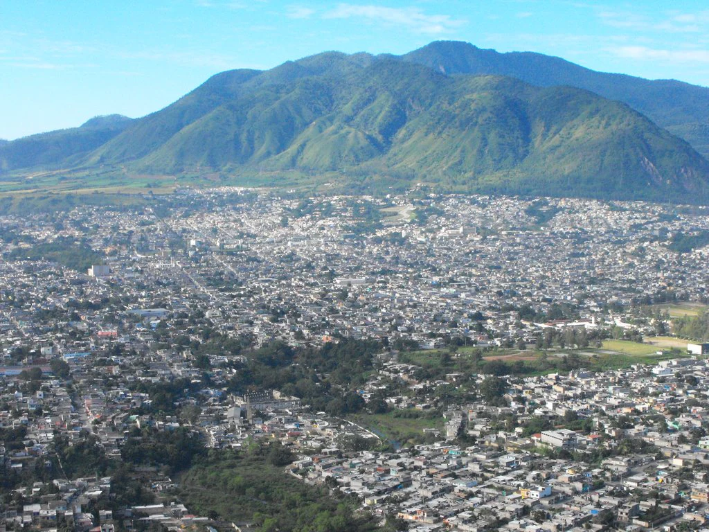
A high-angle view showing a sprawling city in the foreground, leading up to a large, green, rounded mountain range under a clear sky.
A view of the Cerro de San Juan mountain towering over the city of Tepic, Mexico.

Sierra de San Juan Biosphere Reserve history and protected-area timeline

The conservation history of the Sierra de San Juan reflects both grassroots ecological awareness and evolving federal protected-area policy in Mexico. In 1987, the State of Nayarit created the original Sierra de San Juan reserve as a "reserva de conservación y equilibrio ecológico y regeneración del medio ambiente," a state-level designation aimed at conserving the area, maintaining ecological balance, and promoting environmental regeneration. Under this designation, the extraction of construction materials and any activity that damaged flora or fauna was prohibited, and the protected area initially encompassed all land above the 980-meter contour line, totaling roughly 25,977 hectares.

The early reserve was unusual in that it included substantial areas of human use. Approximately 71 percent of the land was held by ejidos, communal agricultural lands worked by local communities under Mexican land reform, while smaller portions belonged to private smallholders, communities, and urban areas. Cultivated plots of coffee, banana, sugarcane, and fruit trees were included within the boundary, and roughly 15,273 people lived inside the reserve, especially in the northeast near Tepic. The reserve was created with relatively little consultation, and local residents feared that their land might be appropriated by the government; the state also did not immediately put a management plan in place, leaving the early years of the reserve as a period of uncertainty for both conservation and local livelihoods.

In 2003, the Mexican federal government redesignated the area as a Special Biosphere Reserve, bringing it under the national protected-area system and adjusting the boundaries. On the drier northern and eastern slopes, the lower boundary was raised to 1,080 meters to exclude heavily urbanized and cultivated zones, while on the moister western and southern slopes the original 980-meter contour was retained to keep the more ecologically sensitive areas within the reserve. The redesignation reduced the protected area to roughly 198 square kilometers but produced a more ecologically coherent reserve, retaining the most biodiverse zones while reducing overlap with intensively used land.

Sierra de San Juan Biosphere Reserve landscape and geographic character

The landscape of the Sierra de San Juan is shaped by its volcanic origins and its position between the Pacific coast and the interior valleys of Nayarit. The reserve encompasses the heart of the Sierra de San Juan range, which forms a clear topographic barrier between the Tepic basin to the east and the Pacific lowlands to the west. Westward, the range descends toward the Pacific coast, which lies only about 22 kilometers away. Eastward, the slopes drain into the Mololoa River, a northward-flowing tributary of the Río Grande de Santiago that passes immediately past Tepic. To the north, the southern flanks of the Sierra Madre Occidental lie roughly 15 kilometers away, giving the Sierra de San Juan a transitional character between two of Mexico's major mountain systems.

The defining peaks of the reserve are twin stratovolcanoes. Cerro Alto, the older and taller of the two, reaches 2,240 meters in elevation and rises in robust, deeply eroded form. Volcán San Juan, somewhat lower, has a distinctive oval caldera approximately one kilometer by four kilometers in dimension, the result of a major eruption roughly 15,000 years ago. Together, these volcanoes mark the westernmost major volcanic features of the Trans-Mexican Volcanic Belt and shape the rugged relief, deep ravines, and varied exposures that drive ecological diversity in the area.

The steep gradient in elevation, combined with differences in slope orientation and proximity to the ocean, produces visually striking contrasts. West-facing slopes are lusher, cloudier, and more humid, while east-facing slopes drop into drier valleys under more variable rainfall. This variability produces a layered landscape in which dry lowland vegetation, mid-elevation pine and oak forests, and mist-shrouded upper slopes all fall within a relatively short vertical distance, making the terrain itself one of the reserve's defining features.

Sierra de San Juan Biosphere Reserve ecosystems, habitats, and plant life

The Sierra de San Juan Biosphere Reserve is ecologically significant because it condenses a remarkable number of vegetation types into a small area, thanks to its volcanic terrain, elevation gradient, and proximity to the Pacific. Plant communities vary with elevation, topography, and degree of human disturbance. At lower elevations, dry forests dominate, with the Jalisco dry forests extending along the coast to the west and the Sinaloan dry forests occupying the warmer valleys of the Mololoa and Río Grande de Santiago to the east and north. These dry communities transition upward into a rich belt of pine forests, oak forests, cloud forest, and high-elevation grasslands.

The higher-elevation pine and oak forests are particularly important because they represent a southern outlier of the Sierra Madre Occidental pine-oak forests, connecting the reserve's plant communities to a much larger biogeographic region that extends far to the north. Cloud forest patches, sustained by moisture-laden air from the Pacific, host rare and locally endemic species such as Magnolia pacifica, a limited-range tree found in the coastal mountains of Nayarit and adjacent Jalisco. Botanical surveys have recorded approximately 1,250 plant species in a broader 400-square-kilometer area surrounding the reserve, equivalent to roughly 30 percent of Nayarit's total plant species, underscoring the area's importance for plant conservation in western Mexico.

The diversity of habitats is matched by a diversity of animals, with over 200 bird species observed across the reserve and 34 mammal species recorded. The combination of dry forests, pine-oak forests, and cloud forest within easy ecological reach of one another allows species with very different habitat preferences to coexist, and the reserve is increasingly valued as a refuge for species sensitive to disturbance in surrounding landscapes.

Sierra de San Juan Biosphere Reserve wildlife and species highlights

Wildlife in the Sierra de San Juan reflects the reserve's role as an ecological crossroads between the dry Pacific lowlands, the moist cloud forests, and the pine-oak highlands of the Sierra Madre Occidental. More than 200 bird species have been observed in the reserve, including an unusually rich assemblage of hummingbirds, with 17 species recorded. These include-specialized cloud forest species such as the Mexican woodnymph and the bumblebee hummingbird, alongside more widely distributed birds such as the crested guan, prairie falcon, common black hawk, and hooded oriole.

The presence of 17 hummingbird species highlights how transitional habitats can support a high diversity of nectar-feeding birds, especially where mist-laden slopes, flowering shrubs, and forest edge coexist. Raptors, forest-dwelling cracids, and a variety of woodland passerines all contribute to the area's value for birdwatching and conservation, and the reserve's elevation gradient allows bird communities to change over relatively short distances.

The reserve also supports at least 34 mammal species, ranging across the diverse habitat types that the Sierra de San Juan contains, although detailed documentation of specific mammal populations is limited in available sources. Overall, the wildlife significance of the reserve lies less in any single charismatic species and more in the mosaic of habitats that allow highly varied animal communities to persist within a compact protected area.

Sierra de San Juan Biosphere Reserve conservation status and protection priorities

The conservation significance of the Sierra de San Juan Biosphere Reserve is rooted in its concentration of biodiversity and its role as a transitional link between major ecosystems of western Mexico. The reserve hosts roughly 30 percent of Nayarit's plant species within a small area, including numerous rare, limited-range, and locally endemic plants such as Magnolia pacifica in the cloud forest zone. By protecting a southern outlier of the Sierra Madre Occidental pine-oak forests alongside Jalisco dry forests, Sinaloan dry forests, and cloud forest, the reserve safeguards multiple ecological communities that are individually threatened elsewhere.

The 2003 redesignation as a Special Biosphere Reserve modernized the legal framework for protecting the area and refined the reserve's boundaries to focus on the most ecologically valuable zones. On the drier northern and eastern slopes, the boundary was raised to 1,080 meters to exclude urbanized and cultivated areas, reducing conflict with local land use; on the moister western and southern slopes, the 980-meter boundary was retained to keep the most sensitive ecosystems inside the reserve. This balance reflects an ongoing recognition that long-term conservation here depends on working with the largely ejido-based land tenure system and the communities that have shaped these landscapes for generations.

As climate and land-use pressures intensify elsewhere in western Mexico, the Sierra de San Juan Biosphere Reserve stands out as an important refuge for dry-forest, cloud forest, and pine-oak forest species, as well as for migratory and endemic birds whose habitat is increasingly fragmented in surrounding regions. Its conservation value is therefore both local, as a stronghold of Nayarit's biodiversity, and regional, as a bridge between the Sierra Madre Occidental and the Pacific coastal ecosystems.

Sierra de San Juan Biosphere Reserve cultural meaning and human context

The Sierra de San Juan has long been a working landscape as well as a natural one. Most of the reserve's land was held by ejidos, communal agricultural lands originating from Mexico's land reform era and still actively managed by local communities, with smaller portions belonging to private smallholders, communities, and urban areas. Within the original reserve boundaries, cultivated plots of coffee, banana, sugarcane, and fruit trees have been part of the everyday environment, and close to 15,000 people lived inside the reserve's original footprint, especially in the northeast near Tepic.

The 1987 creation of the original reserve occurred with relatively little prior consultation, and many residents feared that their land might be taken by the government. The redesignation in 2003 partially addressed these tensions by tightening the boundary to exclude heavily cultivated and urbanized zones, particularly on the drier northern and eastern slopes. Today, the relationship between the reserve and the surrounding communities remains central to its long-term conservation, both because of the land-tenure reality and because traditional agriculture continues to shape the ecological transitions within and around the protected area.

Top sights and standout views in Sierra de San Juan Biosphere Reserve

The reserve's standout qualities include its volcanic landforms, its layered forest communities, and its unusually high botanical diversity within a small footprint. Twin stratovolcanoes, Cerro Alto and Volcán San Juan with its elongated caldera, define the geography, while elevation shifts of more than 1,200 meters compress dry forests, pine-oak forests, cloud forest, and high grasslands into a compact reserve. Botanically, the area offers a remarkable concentration of Nayarit's plant diversity, including rare and locally endemic species such as Magnolia pacifica in the cloud forest zone.

For birdwatchers and ecologists, the reserve is notable for more than 200 recorded bird species, including 17 species of hummingbirds and species such as the Mexican woodnymph, crested guan, common black hawk, and prairie falcon. Its position between the southern Sierra Madre Occidental, the Pacific dry forests, and the Pacific coast makes it a genuine biological crossroads, and its redesignation as a Special Biosphere Reserve in 2003 reflects growing recognition of this regional importance.

Best time to visit Sierra de San Juan Biosphere Reserve

Seasonal conditions in the Sierra de San Juan vary mostly by slope rather than by dramatic shifts in temperature, given the reserve's relatively low latitude. The western and southern slopes, facing the Pacific, receive more rainfall and humidity and tend to be lusher, while the eastern and northern slopes are noticeably drier. Above about 1,600 meters, frequent mists occur through much of the year, and annual rainfall ranges from roughly 1,300 to 1,800 millimeters, with precipitation primarily concentrated in the wet season typical of western Mexico.

Because the higher-elevation forests are best experienced when trails and viewpoints are accessible and when mists enhance the cloud forest atmosphere without making access impossible, visits during the transitional periods between the wet and dry seasons often offer favorable conditions for both scenery and wildlife observation. Birdwatching is rewarding across much of the year, given the reserve's mix of resident and seasonally present species; however, specific timing for viewing particular species or migratory birds would require more detailed local sources.

Monthly climate preview

Track long term temperature rhythms and monthly precipitation patterns across representative coordinates

Sierra de San Juan Biosphere Reserve Climate Normals and Weather by Month

Representative coordinate sampling from nineteen ninety one to twenty twenty reveals measured shifts in monthly mean temperature and precipitation totals for Sierra de San Juan Biosphere Reserve. Consulting the full twelve month record provides granular climatological insight into annual temperature ranges and precipitation rates.
Annual mean24 °C
21 °C27 °C
Jan21°
Feb22°
Mar23°
Apr24°
May26°
Jun27°
Jul26°
Aug26°
Sep25°
Oct25°
Nov23°
Dec21°
Warmest month
June

26.6 °C

Coolest month
January

21 °C

Wettest month
August

10.4 mm/day

Driest month
April

0 mm/day

Park location guide

Geography guide, regional context, and park location map for Sierra de San Juan Biosphere Reserve

Sierra de San Juan Biosphere Reserve park geography, regions, and map view in Mexico

Understand where Sierra de San Juan Biosphere Reserve sits in Mexico through a broader geographic reading of the surrounding landscape, nearby location context, and its mapped position within the national park landscape.

How Sierra de San Juan Biosphere Reserve fits into Mexico

Mexico, officially the United Mexican States, is a country in North America spanning the Sierra Madre mountain ranges, coastal plains, and tropical regions. It borders the United States to the north, Guatemala and Belize to the southeast, and has coastlines along the Pacific Ocean, Gulf of Mexico, and Caribbean Sea. With a population exceeding 130 million, Mexico is home to one of the world's most significant concentrations of Indigenous languages alongside Spanish.

Wider geography shaping Sierra de San Juan Biosphere Reserve in Mexico

Mexico occupies a land area of 1,972,550 km2, making it the thirteenth-largest country in the world. The terrain is highly diverse, featuring the Sierra Madre Occidental and Sierra Madre Oriental mountain ranges, the Mexican Plateau, coastal lowlands along the Pacific and Gulf/Caribbean margins, and the Yucatan Peninsula. The country spans multiple climate zones from desert in the north to tropical rainforest in the south.

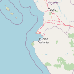
Map view of Sierra de San Juan Biosphere Reserve

Use this park location map to pinpoint Sierra de San Juan Biosphere Reserve in Mexico, understand its exact geographic position, and read its mapped placement within the surrounding landscape more clearly.

Pigeon | © OpenStreetMap contributors

Location context for Sierra de San Juan Biosphere Reserve

Nayarit

Visual reference for volcanic terrain, cloud forests, and mountain habitats

Sierra de San Juan Biosphere Reserve Photos and Protected Landscapes

Visual documentation captures the rugged volcanic relief, twin stratovolcanoes, and layered forest zones defining the mountain range. Photographic records reveal the stark ecological transition from humid cloud forests to dry lowland vegetation across the reserve.

A high-angle view showing a sprawling city in the foreground, leading up to a large, green, rounded mountain range under a clear sky.

Park atlas

Compare nearby mountain ranges, volcanic terrain, and connected protected areas

Parks Near Sierra de San Juan Biosphere Reserve And Regional Protected Landscapes

Continue exploring regional park geography by comparing adjacent protected areas near Sierra de San Juan Biosphere Reserve. Structured atlas comparisons reveal broader ecological corridors, volcanic landforms, and transitional forest zones across western Mexico.
Protected areaMexico
About 64 km away#1 closest

Northeast

Cuenca Alimentadora del Distrito Nacional de Riego 043 Estado de Nayarit: Atlas Overview

Watershed reserve and montane forest geography

This extensive protected area spans the Sierra Madre Occidental, featuring a fragmented landscape of high mountain ridges separated by river valleys. It safeguards critical pine and oak forest ecosystems that supply the Irrigation District 043, serving as a vital natural resource hub in west-central Mexico.

Area
23,290.3 km²
Established
1949
IUCN
VI
Relief
Mountain
National parkNayarit
About 103 km away#2 closest

Northwest

Isla Isabel National Park: Protected Island Landscape within Nayarit's Geography

Explore its mapped boundaries and distinct geography.

Isla Isabel National Park represents a crucial protected area within the broader geographic framework of Nayarit. This national park offers a focused lens for exploring a unique island landscape, its specific mapped boundaries, and its place within the regional atlas. Understanding its ecological and geographic context is key to appreciating this distinct natural landscape.

Area
1.94 km²
Established
1980
IUCN
II
National parkNayarit
About 108 km away#3 closest

Southwest

Islas Marietas National Park: National Park Protected Landscape and Geographic Context

Explore its mapped boundaries and natural terrain in Nayarit.

Discover the distinct protected landscape of Islas Marietas National Park, a vital national park situated in the Nayarit region of Mexico. This entry facilitates a detailed exploration of its mapped geography and protected area status, offering a specific focus on the park's natural terrain and its significance within the broader atlas of conservation lands. Understand the unique context provided by its location and designation for comprehensive geographic discovery.

IUCN
II
Visitors
127.4K annual
Climate
Tropical
Access
Moderate access
Biosphere reserveNayarit
About 155 km away#4 closest

West

Islas Marías Biosphere Reserve: Geographic Overview and Protected Island Mapping

Volcanic topography and marine ecosystems in the Pacific.

The Islas Marías archipelago represents a significant protected area within the Mexican Pacific. Defined by its four major islands and diverse volcanic terrain, the reserve supports unique endemic species and expansive marine ecosystems. This overview tracks the geographic boundaries, island profiles, and the ecological importance of this remote Pacific territory offshore from the state of Nayarit.

Area
244.97 km²
Established
2010
Relief
Upland
Climate
Subtropical
Wildlife reserveJalisco
About 163 km away#5 closest

Southeast

Sierra de Quila: Protected Mountain Geography and Forested Wildlife Reserve in Western Jalisco

Mapped terrain, watershed boundaries, and high-altitude forest ecosystems

Sierra de Quila stands as a prominent protected mountain range in western Jalisco, offering a unique mosaic of pine, oak, and mesophilic cloud forests. This wildlife reserve serves as a essential natural anchor for regional biodiversity and watershed protection, with its rugged canyons and dramatic elevation changes providing a distinct geographical profile within the broader Mexican landscape.

Area
151.92 km²
Established
1982
Relief
Mountain
Climate
Temperate
A horizontal watercolor painting depicting a soft-focus landscape with rolling green hills, patches of forest, and light golden hues representing meadows or dry terrain.
Biosphere reserveJalisco
About 174 km away#6 closest

Southeast

La Primavera Biosphere Reserve: Mapping Volcanic Landscapes and Protected Watersheds

Ecological geography and forest distribution in Jalisco, Mexico

Centering on the Sierra la Primavera volcanic complex, this biosphere reserve functions as an essential green corridor and water catchment zone. The terrain consists of a complex mosaic of vegetation types, including pine-oak forests and relict cloud forest patches across high-elevation ridges. Discover the structural role of these protected lands in moderating the climate and supporting biodiversity in the Guadalajara metropolitan region.

Area
305 km²
Established
2000
IUCN
VI
Relief
Mountain
A watercolor painting showing a panoramic view of rolling hills and a light forest in a park setting.
Protected areaZapopan
About 179 km away#7 closest

Southeast

Bosque el Nixticuil Protected Area: Mapping the Urban Forest Landscape in Zapopan

Volcanic terrain and watershed protection in Jalisco

Bosque el Nixticuil represents a key case of community-led urban conservation. Covering roughly 1,860 hectares in the municipality of Zapopan, this area protects a rare old-growth oak and pine ecosystem from metropolitan development. The park encompasses diverse topographic features including shallow canyons and plains, serving as a vital ecological anchor for the surrounding Río Blanco basin.

Area
18.6 km²
Established
2008
Visitors
3.2M annual
Relief
Mixed relief
A horizontal watercolor illustration depicting rolling green hills and distant muted mountain ranges.
Nature reserveJalisco
About 195 km away#8 closest

Southeast

Barranca de Oblatos: Protected Canyon Nature Reserve and Geographical Landmark in Jalisco

Urban-adjacent nature reserve and protected river corridor

Barranca de Oblatos is a striking geological feature and nature reserve that anchors the biodiversity of the Guadalajara metropolitan region. Featuring a deep canyon system carved by the Rio Grande de Santiago, this protected area holds a complex mosaic of tropical deciduous forests and historical landmarks within its dramatic vertical walls. Explore the landscape context and natural boundaries that define this essential western Mexican wilderness area.

Area
11.37 km²
Established
1997
Relief
Highland
Climate
Subtropical

Common questions about visiting, size, designation, and location context for Sierra de San Juan Biosphere Reserve

Sierra de San Juan Biosphere Reserve FAQs for park facts, access, geography, and protected area context

Find quick answers about Sierra de San Juan Biosphere Reserve, including protected-area facts, park geography, trail and visitor context, and how the park fits into its surrounding country and regional landscape.
MoriAtlas Explorer

Continue Your Protected Areas Search Across the Global Atlas

Deepen your exploration by continuing the structured search for national parks and protected areas worldwide. Utilize the comprehensive filtering capabilities to compare different conservation landscapes and refine your understanding of global park geography. Discover more about the distribution and characteristics of protected natural areas.

Global natural geography