Mori Atlas logo
Nature reserveKai Iwi Lakes Reserve

Explore the unique geomorphic dune basins and clear water ecosystems of this coastal reserve

Kai Iwi Lakes Reserve: A Protected Landscape of Freshwater Dune Lakes in Northland New Zealand

Kai Iwi Lakes Reserve represents a distinct geographic feature in the Northland region, consisting of a chain of three freshwater lakes sculpted by windblown sand dunes. Unlike volcanic or glacial lake systems, this nature reserve is defined by its deep dune basins, white sandy margins, and exceptionally clear water. The surrounding terrain blends native manuka and kanuka scrub with pine plantations and pastoral land, creating a complex mosaic of ecosystems managed for both ecological preservation and natural heritage.

dune lakesfreshwater lakesNorthlandsand dunesnative bushpine plantation

Kai Iwi Lakes Reserve

Nature reserve

Park overview

Structured park overview, official facts, and landscape profile for Kai Iwi Lakes Reserve

Kai Iwi Lakes Reserve park facts, protected area profile, and essential visitor context

Review the core facts for Kai Iwi Lakes Reserve, including designation, size, terrain, visitor scale, habitats, and operating context in one park-focused overview.

About Kai Iwi Lakes Reserve

Kai Iwi Lakes Reserve is a Northland nature reserve defined by a tightly clustered chain of three freshwater dune lakes within the Taharoa Domain, a roughly 538 hectare block of dunes, pasture, pine, and regenerating native bush. The reserve is located about 35 kilometres northwest of Dargaville, near the western side of the North Island, where coastal sand country meets flat dairy farmland in a gentle landscape of low dunes and inland basins.

The three lakes, Lake Taharoa, Lake Kaiiwi, and Lake Waikare, each occupy basins formed or shaped by windblown sand, a defining characteristic of dune lakes found in the western Northland region. Together they form an unusual hydrological sequence: Lake Taharoa is the largest and contributes minor inflows into Lake Kaiiwi, which itself has no outflow; Lake Waikare sits apart, separated from the others by stretches of dune. The surrounding catchments are a mosaic of high-producing exotic pasture, exotic pine forest, and manuka and kanuka scrub, with some areas showing a mixture of cover types.

Beyond the lakes themselves, the reserve is increasingly appreciated for what surrounds them. The clean water, white sandy margins, and sheltered dunes give the area its recreation appeal, while walking tracks and camping facilities extend the visitor experience into the bush and dunes. Lake Kaiiwi's name preserves a link to a local chief, Te Kaiiwi, and to the historical Battle of Lake Kaiiwi, giving the reserve a meaningful local and Maori cultural dimension in addition to its natural values. Lake Taharoa's name, derived from the Maori 'taha' (coast) and 'roa' (long), translates to 'long coast' and reflects the lakes' proximity to the sweeping Ripiro Beach shoreline to the west.

Kai Iwi Lakes Reserve is widely regarded as a flagship example of the freshwater dune lake systems that define Northland's western sand country. The lakes are anchored in the region's environmental identity, valued as much for their everyday recreation role as for the rare hydrological and ecological patterns they embody.

Quick facts and research context for Kai Iwi Lakes Reserve

Kai Iwi Lakes Reserve sits within Taharoa Domain, covering roughly 538 hectares of sand dunes, native bushland, and interconnected freshwater lakes in Northland, New Zealand. The reserve features three named dune lakes: Lake Taharoa, the largest and deepest; Lake Kaiiwi; and Lake Waikare, the smallest.

Lake Taharoa has a surface area of around 197 hectares and a maximum depth of about 31.8 metres, with submerged aquatic vegetation recorded to a depth of approximately 24 metres, making it one of the clearest and deepest dune lakes on the North Island. The catchment is dominated by exotic pasture, exotic pine forest, and manuka and kanuka scrub, while rainfall in the area averages roughly 1,400 mm per year. Water quality across the lakes is generally high, with Lake Taharoa typically ranked in the best water quality category under New Zealand's National Policy Statement for Freshwater Management.

Protection and recognition

Review documented terrestrial protection metrics and official international recognition records.

Kai Iwi Lakes Reserve Protection Status and Designated Conservation Scope

Kai Iwi Lakes Reserve maintains a documented terrestrial protection scope without international recognition sources or transboundary status designations. Detailed conservation records outline the established management framework and administrative oversight for the protected landscape.

Protection details

Protection scope
Terrestrial
Transboundary protection
No
Park context

Deeper park guide and search-rich context for Kai Iwi Lakes Reserve

Kai Iwi Lakes Reserve history, landscape, wildlife, and travel context

Explore Kai Iwi Lakes Reserve through its history, landscape character, ecosystems, wildlife, conservation priorities, cultural context, and seasonal travel timing in a structured park guide built for atlas discovery and search intent.

Why Kai Iwi Lakes Reserve stands out

Kai Iwi Lakes Reserve is best known for its chain of exceptionally clear freshwater dune lakes, a geomorphic feature rarely seen outside of the Northland sand country. Lake Taharoa in particular stands out as one of New Zealand's largest and deepest dune lakes, recognised as one of the best examples of a clear-water lake in Northland and notable for hosting submerged vegetation at depths rarely recorded in North Island lakes. The reserve is also recognised for the unusual interplay between pastoral, plantation, and native vegetation that surrounds the lakes, and for the way the dune-formed basins create sharply contrasting shorelines with steep drop-offs, gentle sloping beaches, and sheltered basins that incubate emergent plant communities. Together these features give the reserve a distinctive identity that blends natural lake science with a relaxed, beach-like recreation atmosphere.

Kai Iwi Lakes Reserve history and protected-area timeline

The name Lake Kaiiwi commemorates Te Kaiiwi, a local chief who is recognised as the first person to visit the lake, while the lake itself is the historic site of the Battle of Lake Kaiiwi. The Maori name Taharoa, meaning 'long coast', reflects the lakes' geographic setting close to the long sweep of Ripiro Beach, suggesting that the wider area has long held cultural and place-name significance for local Maori.

The broader reserve area, Taharoa Domain, has been used and managed for an extended period, with the modern reserve emerging around the protection of the lakes and surrounding dune and bush country. Historical rainfall records from stations including Fanning rainfall station and McLeods at Kai Iwi, dating back to the 1980s, indicate that baseline climate monitoring of the lakes has been in place for several decades, supporting ongoing scientific attention to the lakes' water quality and ecology. National water quality assessments, such as those reported under the National Policy Statement for Freshwater Management, have continued to highlight the lakes' exceptional clarity and ecological condition, especially for Lake Taharoa.

Kai Iwi Lakes Reserve landscape and geographic character

The landscape of Kai Iwi Lakes Reserve is shaped by windblown sand, giving the area a distinctive dune-lake topography that contrasts with most other New Zealand lake environments. Instead of glacier-carved cirques or volcanic craters, the basins here are formed and reworked by sand movement, creating rounded dune ridges and shallow swales that separate the lakes from one another and from the broader coastal plain.

The reserve sits within a broader mosaic of dunes, exotic pasture, exotic pine plantations, and manuka and kanuka scrub, with the lake margins themselves ranging from gently sloping sandy beaches to steep underwater drop-offs. Lake Taharoa has a complex bathymetry, with a deep central basin, two shallower basins, and a discrete nearly closed basin at its western end, while Lake Waikare undulates across three basins and Lake Kaiiwi shows clear shoreline contrasts between scrub-covered and pine-fringed margins.

To the west, the reserve lies close to Ripiro Beach, lending the area a strong sense of coastal-proximate scenery, with white sand, clear freshwater, and low dune ridges combining into a soft, beach-like atmosphere. The inland rolling pastoral land and pine stands frame the lakes with a quieter, more utilitarian agricultural horizon, balancing the wild dune character of the lake basins themselves.

Kai Iwi Lakes Reserve ecosystems, habitats, and plant life

Ecologically, Kai Iwi Lakes Reserve is defined by the freshwater dune lake habitats that anchor the reserve and by the mosaic of land covers in their catchments. The lakes are classified as window dune lakes, meaning that they sit within the water table and receive inputs from rainfall, springs, and overland flows; Lake Kaiiwi, by contrast, may function as a perched dune lake above the water table, adding diversity to the hydrological story of the reserve.

The catchment is a layered mix of high-producing exotic grassland pasture, exotic pine plantations, and manuka and kanuka scrubland, with smaller patches of mixed vegetation. These land covers shape the nutrient, sediment, and light conditions reaching the lakes and influence the distribution of emergent plant communities along the lake margins. Lake Kaiiwi, in particular, supports dense emergent plant growth in its northeastern area, which acts as a natural filter for nutrients moving from the wider catchment into the lake.

Lake Taharoa is recognised for exceptionally clear water and for hosting submerged aquatic vegetation to a recorded depth of around 24 metres, among the deepest recorded submerged vegetation for any North Island lake. The water column in each lake shows thermal stratification during warmer months, and nutrient and trophic assessments place Lake Taharoa in the low oligotrophic to microtrophic range, indicating very good water quality, while Lake Kaiiwi has improved into the oligotrophic range and Lake Waikare remains in the medium oligotrophic range.

Kai Iwi Lakes Reserve wildlife and species highlights

The wildlife profile of Kai Iwi Lakes Reserve reflects its freshwater and bush-edge habitats. The clear, well-oxygenated dune lakes support recreational fisheries for introduced freshwater species, including rainbow trout, brown trout, and perch, establishing the lakes as an inland angling destination.

Surrounding and wetland habitats, particularly around Lake Kaiiwi's vegetated northeastern margins and the broader manuka and kanuka scrub, support birdlife typical of northern New Zealand dune-lake and regenerating bush environments. The walkable mix of native bush, pine edges, and lake margins encourages casual birdwatching alongside water-based recreation.

While the reserve does not host a roster of large charismatic mammals, its combination of clean water, diverse aquatic vegetation, and adjacent native vegetation offers meaningful habitat for waterbirds, fish, and the smaller woodland species typical of Northland's regenerating bush.

Kai Iwi Lakes Reserve conservation status and protection priorities

Kai Iwi Lakes Reserve's primary conservation significance lies in its freshwater dune lake systems, a relatively uncommon lake type in New Zealand that is especially characteristic of western Northland. The lakes together represent a regionally important concentration of this lake type, with Lake Taharoa singled out as probably the best example of a clear-water lake in Northland and one of the largest and deepest dune lakes in the country.

Water quality is a central conservation theme. Under the National Policy Statement for Freshwater Management, Lake Taharoa consistently performs in the highest phytoplankton and nitrogen categories, while Lake Kaiiwi and Lake Waikare typically rank in good but slightly more variable categories. Phosphorus and toxic ammonia levels across all three lakes are reported in the best state category, and the trophic state of the lakes ranges from oligotrophic in Lake Kaiiwi to low oligotrophic and even microtrophic in Lake Taharoa. Together these indicators suggest that the reserve remains an important reference point for intact or near-intact dune lake water quality.

Surrounding land uses, including pasture, pine plantation, and scrub, shape nutrient and sediment flows into the lakes, with the dense emergent plant communities around Lake Kaiiwi assisting in natural nutrient filtering. The reserve's protected status through Taharoa Domain offers a framework within which these ecological values can be maintained alongside ongoing recreation use.

Kai Iwi Lakes Reserve cultural meaning and human context

Kai Iwi Lakes Reserve carries a clear Maori cultural layer in its place names and historical associations. Lake Taharoa derives its name from the Maori words 'taha', meaning coast, and 'roa', meaning long, together 'long coast', a name that captures the lakes' setting along the long sweep of Ripiro Beach. Lake Kaiiwi is named after chief Te Kaiiwi, recognised as the first person to visit the lake, and the lake is also the site of the historic Battle of Lake Kaiiwi, anchoring the reserve to a deeper regional Maori narrative.

The broader Northland sand country has long-standing significance for local Maori, and the deliberate preservation of these names within the reserve reflects a continued respect for that heritage. While the reserve is primarily framed around natural and recreation values, its cultural names and associations add a meaningful layer of regional identity and indigenous heritage to the visitor experience.

Top sights and standout views in Kai Iwi Lakes Reserve

Kai Iwi Lakes Reserve's standout highlights include a cluster of three freshwater dune lakes within a single protected domain, including Lake Taharoa, one of the largest and deepest dune lakes in New Zealand; Lake Kaiiwi, a vegetated nutrient-filtering lake tied to a named Maori chief; and Lake Waikare, a separate dune-lake basin with its own distinct shoreline character.

The reserve's exceptionally clear water, white sandy margins, and submerged aquatic vegetation recorded to unusual depths set it apart from typical New Zealand lake environments. Walking tracks, camping areas, and picnic facilities weave recreation and ecological value into a single, accessible Northland destination that remains closely tied to its Maori place-name heritage and the long coastline of nearby Ripiro Beach.

Best time to visit Kai Iwi Lakes Reserve

Kai Iwi Lakes Reserve is at its most appealing during the warmer months, when the clear freshwater and sandy margins lend themselves naturally to swimming, kayaking, paddleboarding, boating, and water skiing on Lake Taharoa. Visitation tends to peak in this period, when the lake-side atmosphere is at its most beach-like and the dune-and-bush scenery is complemented by longer daylight hours and stable weather.

The regional climate is mild year-round, with average temperatures in nearby Dargaville ranging from around 11°C in July to about 20°C in February. Rainfall is moderate, with the wettest months typically June and July and drier conditions from November to February, so late spring through early autumn generally offers comfortable conditions for both water-based recreation and walking the trails around the lakes. Off-season visits can offer a quieter, more contemplative experience for birdwatching and bush walks, though cooler water temperatures make swimming less inviting outside the warmest months.

Monthly climate preview

Long-term temperature ranges and precipitation averages recorded at reference coordinates

Kai Iwi Lakes Reserve Climate Normals and Representative Monthly Weather Patterns

Representative coordinate sampling records mean monthly temperatures spanning from 12.85 degrees Celsius to 20.52 degrees Celsius alongside corresponding precipitation rates. Complete twelve-month statistical tables detail full temperature extremes and precipitation distributions across the protected landscape.
Annual mean16 °C
13 °C21 °C
Jan20°
Feb21°
Mar19°
Apr18°
May16°
Jun14°
Jul13°
Aug13°
Sep14°
Oct15°
Nov16°
Dec18°
Warmest month
February

20.5 °C

Coolest month
August

12.9 °C

Wettest month
July

4.4 mm/day

Driest month
February

2.1 mm/day

Park location guide

Geography guide, regional context, and park location map for Kai Iwi Lakes Reserve

Kai Iwi Lakes Reserve park geography, regions, and map view in New Zealand

Understand where Kai Iwi Lakes Reserve sits in New Zealand through a broader geographic reading of the surrounding landscape, nearby location context, and its mapped position within the national park landscape.

How Kai Iwi Lakes Reserve fits into New Zealand

New Zealand is an island nation in the southwestern Pacific Ocean comprising two main islands and numerous smaller islands. Located east of Australia across the Tasman Sea, it features varied topography with the Southern Alps running along the South Island and volcanic terrain on the North Island. The country was settled by Maori people between 1280 and 1350, followed by European exploration beginning in 1642, and became a Dominion in 1907 before gaining full independence in 1947.

Wider geography shaping Kai Iwi Lakes Reserve in New Zealand

New Zealand lies in the southwestern Pacific Ocean, east of Australia across the Tasman Sea. The country consists of two main islands, the North Island and South Island, plus over 600 smaller islands. The North Island features volcanic plateaus and hills while the South Island is dominated by the Southern Alps mountain range. The country has a long coastline and is surrounded by the Pacific Ocean.

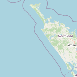
Map view of Kai Iwi Lakes Reserve

Use this park location map to pinpoint Kai Iwi Lakes Reserve in New Zealand, understand its exact geographic position, and read its mapped placement within the surrounding landscape more clearly.

Pigeon | © OpenStreetMap contributors

Location context for Kai Iwi Lakes Reserve

Northland Region
Park atlas

Discover related national parks and regional reserves across the Northland terrain.

Explore Parks Near Kai Iwi Lakes Reserve and Surrounding Protected Landscapes

Compare coastal dune lakes, native bush reserves, and protected areas situated near Kai Iwi Lakes Reserve. Extending your geographic search reveals wider regional conservation landscapes and neighboring park geography.
Nature reserveNew Zealand
About 21 km away#1 closest

Northwest

Waipoua Forest Nature Reserve: An Atlas of Ancient Kauri and Northland Rainforest

Charting the protected ecological boundaries and humid temperate geography

Waipoua Forest represents a vital protected landscape in Northland, New Zealand, characterized by deep, rain-fed valleys and towering kauri stands. This nature reserve sustains one of the largest clusters of old-growth trees in the country, maintaining a dense, multi-layered forest structure that stands in sharp contrast to the modified land on its margins. The sanctuary remains a primary reference point for understanding the wet, hilly terrain of the North Island west coast.

Area
80 km²
Established
1952
Visitors
200K annual
Relief
Upland
Nature reserveNew Zealand
About 62 km away#2 closest

Northeast

Waro Limestone Scenic Reserve: Karst Landscapes and Cultural Heritage in Northland, New Zealand

A study in geological formations and industrial history.

Waro Limestone Scenic Reserve offers a concentrated look at Northland geography, featuring vertical limestone outcrops and a flooded quarry set within rural farmland. As a protected nature reserve, it serves as a site of significant Māori cultural heritage while also preserving remnants of early New Zealand industrial activity, such as coal mining and lime extraction, which shaped the surrounding terrain.

Relief
Upland
Climate
Subtropical
Scope
Terrestrial
Water
Minor water
Regional parkAuckland Region
About 92 km away#3 closest

Southeast

Te Rau Pūriri Regional Park: Geography and Protected Land Overview for Auckland Region

Coastal harbour landscape and native forest recovery zones

Te Rau Pūriri Regional Park occupies a strategic position on the South Kaipara Head, serving as a protected corridor between agricultural land and the expansive Kaipara Harbour. The park serves as an atlas-worthy example of ecological transition, featuring sandy bays, eucalyptus stands, and native pūriri forests that provide habitat stability within the wider Auckland coastal geography.

Area
2.49 km²
Established
2006
Relief
Lowland
Climate
Temperate
Regional parkAuckland Region
About 93 km away#4 closest

Southeast

Te Ārai Regional Park: Mapping Coastal Dune Systems and Protected Geography in Auckland

A protected coastal landscape featuring expansive dune systems and northern headlands.

Te Ārai Regional Park sits as a major protected coastal area on the northern edge of the Auckland Region. Its primary defining feature is an expansive system of sand dunes that anchor a diverse coastal environment. Extending southward toward Poutawa Stream and bordered by the Mangawhai Forest, the park represents a critical geography for endangered species breeding and provides a distinct topographic profile along the North Island coast.

Established
2008
Relief
Lowland
Climate
Subtropical
Access
Easy access
A pale, minimalist watercolor painting depicting soft green and pink hilly island silhouettes rising from a calm, white-toned sea.
Marine protected areaNew Zealand
About 98 km away#5 closest

East

Poor Knights Islands Marine Reserve: Geography and Marine Protected Area Atlas

Exploring coastal cliffs and underwater volcanic terrain

The Poor Knights Islands Marine Reserve encompasses a protected 1,890 hectare marine environment renowned for its steep underwater walls and tunnel systems. Located off the coast of New Zealand, this reserve serves as a critical study area for marine conservation and ecosystem recovery. Explore the geological features, including the Northern Arch and rugged offshore rock stacks, which distinguish this maritime landscape.

Area
18.9 km²
Established
1981
Access
Access unknown
Scope
Marine
A watercolor illustration of a soft green hilly landscape with distant peaks against a white background.
Nature reserveNew Zealand
About 98 km away#6 closest

East

Hen and Chicken Islands Nature Reserve: Mapped Geography and Protected Island Terrain

Archipelago sanctuary and volcanic landscape offshore of New Zealand

Explore the geographic structure of the Hen and Chicken Islands, an uninhabited nature reserve that serves as a vital predator-free sanctuary. The archipelago displays varied volcanic terrain, from the dramatic central ridge of Hen Island to the rugged rocky reefs of the Marotiri islets, offering a clear window into the ecological conservation landscapes of the Northland region.

Area
8.44 km²
Established
1908
Relief
Highland
Climate
Subtropical
Nature reserveNorthland Region
About 105 km away#7 closest

East

Poor Knights Islands Nature Reserve: Mapped Volcanic Geography and Protected Coastal Landscapes

A rugged island chain offshore from New Zealand's Northland Region.

The Poor Knights Islands serve as an essential protected landscape characterized by sheer volcanic cliffs, natural arches, and extensive sea cave systems. Rising sharply from the sea, these uninhabited islands function as a vital sanctuary for seabirds and native flora, providing a unique look into the deeply eroded remnants of ancient rhyolitic volcanic activity within New Zealand.

Area
2.714 km²
Established
1975
IUCN
Ia
Relief
Upland
A watercolor painting showing a soft, bright landscape with green grasses and wildflowers on both sides of a calm, pale blue body of water, with a green coastline in the distance.
Marine protected areaNew Zealand
About 112 km away#8 closest

Southeast

Cape Rodney-Okakari Point Marine Reserve: New Zealand Marine Protected Area Geography

Mapped coastal boundaries and marine ecosystem terrain

Delve into the geography of Cape Rodney-Okakari Point Marine Reserve, where protected waters meet a complex interface of greywacke bedrock and sandy substrates. This assessment highlights the ecological transition from exposed rocky headlands to sheltered Whangateau Harbour, illustrating the structural depth of New Zealand's foundational marine site through its diverse invertebrate and fish habitats.

Area
5.5 km²
Established
1975
IUCN
Ia
Visitors
200K annual

Common questions about visiting, size, designation, and location context for Kai Iwi Lakes Reserve

Kai Iwi Lakes Reserve FAQs for park facts, access, geography, and protected area context

Find quick answers about Kai Iwi Lakes Reserve, including protected-area facts, park geography, trail and visitor context, and how the park fits into its surrounding country and regional landscape.
MoriAtlas Explorer

Continue Your Protected Areas Search Across the Global Atlas

Deepen your exploration by continuing the structured search for national parks and protected areas worldwide. Utilize the comprehensive filtering capabilities to compare different conservation landscapes and refine your understanding of global park geography. Discover more about the distribution and characteristics of protected natural areas.

Global natural geography