

Mori Atlas logo
Nature reserveWaro Limestone Scenic Reserve

Tracing the intersection of sacred Māori heritage, dramatic limestone formations, and industrial history.

Waro Limestone Scenic Reserve: Mapping the Protected Karst Landscapes of Northland, New Zealand

Waro Limestone Scenic Reserve functions as a significant protected area in Northland, New Zealand, preserving a distinct cluster of limestone outcrops that rise from the rural countryside. The reserve is anchored by the prominent Cathedral Rock and maintains deep cultural importance as a waahi tapu site for local Māori iwi. Beyond its natural geological features, the terrain reveals layers of early industrial history, including remnants of coal mines, tramways, and a flooded marble quarry that define this unique landscape.

limestone formationskarst scenerygeological reservescenic reserveindigenous sacred siteswaahi tapu
A flat-style vector illustration of a tall, pale limestone monolith rising above a verdant valley with a small waterfall flowing into a stream, surrounded by coniferous trees.

Waro Limestone Scenic Reserve

Nature reserve

Park overview

Structured park overview, official facts, and landscape profile for Waro Limestone Scenic Reserve

Waro Limestone Scenic Reserve park facts, protected area profile, and essential visitor context

Review the core facts for Waro Limestone Scenic Reserve, including designation, size, terrain, visitor scale, habitats, and operating context in one park-focused overview.

About Waro Limestone Scenic Reserve

Waro Limestone Scenic Reserve is a compact conservation area in Northland, on New Zealand's North Island, that protects a notable group of limestone rock formations near the small settlement of Waro and the larger service town of Hikurangi. The reserve lies in a rural part of the Whangārei district, just inland from the northern approaches to Whangārei city, and is dominated visually by tall, pale limestone outcrops that rise abruptly from the surrounding pasture and bush. The most photographed of these is Cathedral Rock, a freestanding formation whose name reflects its spire-like profile.

The identity of the reserve is shaped by three overlapping layers: geological, cultural, and industrial. Geologically, the limestone outcrops represent a distinctive localised landscape feature within the soft, rolling country north of Whangārei. Culturally, the rocks hold deep significance for local Māori, who classify them as waahi tapu and have historically used them for ceremonial purposes. Industrially, the broader Waro area became one of the significant coal-mining districts of nineteenth and early twentieth century New Zealand, and later a source of decorative limestone that was shipped to major centres for use in prominent government buildings.

Although the reserve is small in scale and does not function as a major national park style destination, it remains an important local landmark. It provides a rare example of a protected natural area in which dramatic karst-like limestone scenery, living Māori sacred tradition, and a rich colonial industrial past coexist within a single compact landscape.

Quick facts and research context for Waro Limestone Scenic Reserve

Waro Limestone Scenic Reserve sits about 16 kilometres north of Whangārei on New Zealand's North Island, in the Northland region near Hikurangi. It is a small protected area centred on a group of notable limestone outcrops, including the well known Cathedral Rock. The reserve holds waahi tapu status for several Māori iwi, reflecting its long-standing sacred role. The surrounding district has a significant industrial heritage, with extensive nineteenth and early twentieth century coal mining and a later marble quarry that supplied limestone for notable government buildings across New Zealand. The old quarry is now a flooded lake within the wider reserve area.

Protection and recognition

Examine the documented conservation scope and formal protected area designation details.

Waro Limestone Scenic Reserve Protection Status And International Recognition

Waro Limestone Scenic Reserve maintains a defined terrestrial protection status within its regional landscape. Structured records outline the official management scope and formal designation framework governing the protected area.

Protection details

Protection scope
Terrestrial
Transboundary protection
No
Park context

Deeper park guide and search-rich context for Waro Limestone Scenic Reserve

Waro Limestone Scenic Reserve history, landscape, wildlife, and travel context

Explore Waro Limestone Scenic Reserve through its history, landscape character, ecosystems, wildlife, conservation priorities, cultural context, and seasonal travel timing in a structured park guide built for atlas discovery and search intent.

Why Waro Limestone Scenic Reserve stands out

Waro Limestone Scenic Reserve is best known for its cluster of dramatic limestone formations, particularly Cathedral Rock, which has been a local landmark and photographic subject since at least the early twentieth century. The reserve is equally recognised for its status as a waahi tapu, a sacred site held by Ngāti Hau, Ngāti Kahu O Torongare, and Ngāti Wai. The reserve also stands out for the way its natural geology intersects with industrial history. The same limestones that form the scenic outcrops were mined for coal beneath the cliffs, quarried for decorative building stone, and burned in nearby lime kilns, leaving a layered cultural and physical landscape that blends natural heritage with the early extractive history of the Whangārei district.
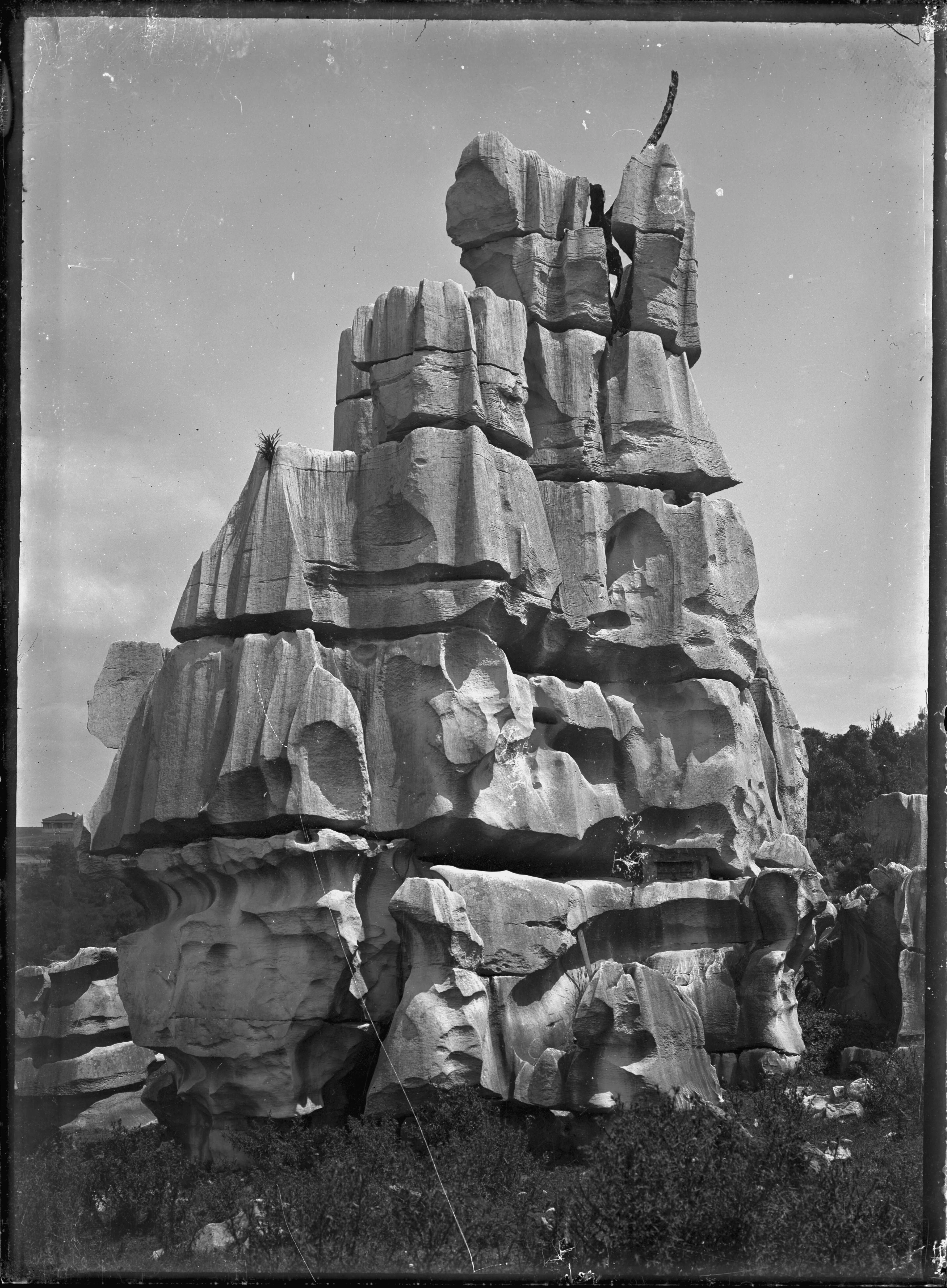
A black and white archival photograph of the tall, jagged, and weathered limestone formation known as Cathedral Rock at Waro.
Cathedral Rock, a weathered limestone formation, captured in 1923.

Waro Limestone Scenic Reserve history and protected-area timeline

The limestone formations of Waro have long been part of the cultural landscape of local Māori. The iwi of Ngāti Hau, Ngāti Kahu O Torongare, and Ngāti Wai used the rocks for ritual purposes and regard them as waahi tapu, sacred sites whose significance continues into the present. For Māori in this part of Northland, Waro predates any European interest as a place of ceremonial and spiritual value.

European engagement with the area began in earnest with the discovery of coal in the 1860s. Although the first formal mine did not open until 1889, the district eventually hosted up to sixty or seventy coal mines that produced around 4.2 million tons of coal in total. The largest operators included the Hikurangi Coal Company, the Wilson Colliery Company, and the Northern Coal Mine Company. A network of narrow-gauge railways, including the Waro Horse Tramline built between 1894 and 1905, connected the mines with lime kilns and the main Hikurangi Kamo State Railroad.

The Hikurangi Coal Company operated a mine directly beneath the limestone cliffs from 1913, with interruptions during the First World War and a reopening in 1921 by Wilson Collieries to supply fuel for the Portland cement works. This mine closed in 1933 due to flooding. The Northern Colliery Company, meanwhile, ran a notable narrow-gauge line serviced by a small Orenstein and Koppel steam locomotive later preserved in Auckland.

From the 1920s to the 1940s, the Whangarei Limestone Company quarried what became known as Whangarei Limestone, or Waro stone, a shelly limestone in yellow, cream, and pink-tinted varieties, from a site now flooded as a quarry lake beside Waro railway station. The stone was used in prominent buildings across New Zealand, including Wellington Railway Station, Auckland Railway Station, the Napier Post Office, Wellington Central Library, Dunedin Post Office, and Dunedin Town Hall. The quarry later supplied high-grade limestone to Wilson's Cement, predecessor of Golden Bay Cement, until the nearby Wilsonville Quarry opened in 1974. The old quarry was then transferred to Whangarei District Council as a reserve, forming part of the present-day protected landscape.

Waro Limestone Scenic Reserve landscape and geographic character

The defining landscape feature of Waro Limestone Scenic Reserve is a tightly grouped set of pale limestone outcrops that rise vertically from a softer surrounding countryside of pasture, regenerating bush, and rural Northland farmland. The most striking of these is Cathedral Rock, a tall, weathered formation with a distinctive spire-like profile that has been photographed and illustrated since at least the early twentieth century. Around it sit several other abrupt limestone formations whose shapes reflect long weathering of the local bedrock.

The reserve sits in a transitional landscape between the coastal lowlands of the Whangārei area and the slightly more elevated countryside to the north. The terrain around the rocks is gentle and rolling, which makes the sudden appearance of the steep limestone faces all the more visually dramatic. A flooded former marble quarry now forms a small lake between the outcrops and the railway line, adding an unexpected body of water to a landscape otherwise defined by rock and grass.

The visual character of the reserve is one of contrast: white or pale grey vertical limestone against green farmland, small pockets of native vegetation, and a still quarry lake that reflects the cliff lines. This juxtaposition of natural karst-like scenery and human-shaped features, including old rail routes, mine entrances, and quarry edges, gives the reserve a layered and unusual appearance for its small size.

Waro Limestone Scenic Reserve ecosystems, habitats, and plant life

Ecologically, Waro Limestone Scenic Reserve reflects a typical Northland mix of modified rural landscape and pockets of native vegetation growing on and around the limestone outcrops. The rocky faces themselves support hardy plant communities adapted to thin soils and exposed conditions, while the surrounding lower ground carries pasture and regenerating shrubland typical of long-settled Northland farmland.

The reserve's vegetation includes traces of early European settlement in unexpected forms. Privet, introduced daffodils, and peppermint plants have established themselves in the area, likely originating from plantings brought in by nineteenth century settlers. Their presence is part of the reserve's character, marking the long intersection between human settlement and natural landscape at Waro.

More broadly, the limestone formations contribute a localised habitat type within the wider Whangārei district, providing refuge for plants and invertebrates suited to rocky, calcium-rich environments that differ from the surrounding soils. Although the reserve is small, its geology gives it an ecological niche that complements the broader mix of coastal, forest, and rural habitats that characterise Northland.

Waro Limestone Scenic Reserve wildlife and species highlights

The source material for Waro Limestone Scenic Reserve does not describe the park's wildlife in any meaningful detail, so a substantive wildlife section cannot be supported. The area's small reserves size, surrounding farmland, and focus on geology and cultural heritage suggest a modest wildlife presence shaped largely by the wider Northland rural environment rather than by a distinct reserve-specific fauna, but specific information about birds, reptiles, or mammals is not available.

Waro Limestone Scenic Reserve conservation status and protection priorities

Waro Limestone Scenic Reserve holds conservation value for reasons that go beyond its scenic appearance. The reserves formal protection of the limestone outcrops preserves a locally important geological feature from further quarrying or development, while its council reserve status, inherited from the old marble quarry in the 1970s, reflects a deliberate shift in land use from extraction to long-term public and ecological stewardship.

Equally significant is the protection the reserve effectively affords to sites of deep cultural and spiritual importance. By maintaining the rock formations as a public reserve under local authority oversight, the area is shielded from activities that could compromise their status as waahi tapu for Ngāti Hau, Ngāti Kahu O Torongare, and Ngāti Wai. The reserve therefore represents a convergence of geological, cultural, and community-based conservation values.

Within the wider Hikurangi and Whangārei context, the reserve also serves as a tangible reminder of Northland's extractive past and the transition from coal mining and limestone quarrying toward conservation-oriented land use. Its preservation offers continuity between the area's nineteenth and twentieth century industrial history and its present role as a local natural and cultural landmark.

Waro Limestone Scenic Reserve cultural meaning and human context

The cultural identity of Waro Limestone Scenic Reserve is dominated by its long-standing significance to local Māori iwi. The rocks are regarded as waahi tapu, sacred sites, by Ngāti Hau, Ngāti Kahu O Torongare, and Ngāti Wai, and were historically used for ritual purposes. This sacred designation continues to shape how the formations are treated and understood, giving the reserve a cultural depth that extends well beyond its physical size.

European settlement introduced a second, layered cultural dimension. The late nineteenth and early twentieth century coal mining industry, with its narrow-gauge tramways, small steam locomotives, and lime production, drew workers and their families into the area and left enduring physical traces in the landscape. The later quarrying of Whangarei Limestone for prestigious government buildings across New Zealand connected Waro directly to the architectural identity of the wider country.

Together, these Māori and European strands make the reserve a place where one small Northland locality embodies a broader story of indigenous sacred landscape and colonial industrial development. The reserve's protected status enables both dimensions of this heritage to be recognised and preserved in a single, accessible setting.

Top sights and standout views in Waro Limestone Scenic Reserve

Waro Limestone Scenic Reserve's principal highlight is Cathedral Rock, a tall, freestanding limestone formation that has defined the area's visual identity since at least the early twentieth century and remains its most recognisable feature. Equally important is the reserve's waahi tapu status, marking the limestone formations as sacred sites for Ngāti Hau, Ngāti Kahu O Torongare, and Ngāti Wai.

The reserve also offers a striking industrial landscape, with traces of nineteenth and early twentieth century coal mines, narrow-gauge tramlines, lime kilns, and a flooded former marble quarry now forming a small lake. The quarry supplied the distinctive Waro limestone used in landmark buildings such as Wellington Railway Station, Auckland Railway Station, the Napier Post Office, Wellington Central Library, Dunedin Post Office, and Dunedin Town Hall, giving the local stone a presence in major civic architecture across New Zealand.

Best time to visit Waro Limestone Scenic Reserve

Based on the source material, there is no detailed information about seasonal access or weather conditions at Waro Limestone Scenic Reserve. As a small Northland reserve on lower-lying terrain, it is likely accessible year-round in typical New Zealand conditions, but no specific seasonal guidance can be reliably drawn from the available sources.
Monthly climate preview

Long-term representative temperature and precipitation averages for New Zealand

Waro Limestone Scenic Reserve Climate Normals and Annual Weather Patterns

Waro Limestone Scenic Reserve records long-term average temperatures peaking above twenty-six degrees Celsius alongside varied monthly precipitation rates from NASA climatology data. Examining the complete twelve-month temperature and precipitation profile provides detailed context on local environmental conditions at the representative coordinate.
Annual mean16 °C
12 °C21 °C
Jan20°
Feb21°
Mar19°
Apr17°
May15°
Jun13°
Jul12°
Aug12°
Sep13°
Oct15°
Nov16°
Dec19°
Warmest month
February

20.6 °C

Coolest month
August

12.4 °C

Wettest month
July

4.5 mm/day

Driest month
October

2.2 mm/day

Park location guide

Geography guide, regional context, and park location map for Waro Limestone Scenic Reserve

Waro Limestone Scenic Reserve park geography, regions, and map view in New Zealand

Understand where Waro Limestone Scenic Reserve sits in New Zealand through a broader geographic reading of the surrounding landscape, nearby location context, and its mapped position within the national park landscape.

How Waro Limestone Scenic Reserve fits into New Zealand

New Zealand is an island nation in the southwestern Pacific Ocean comprising two main islands and numerous smaller islands. Located east of Australia across the Tasman Sea, it features varied topography with the Southern Alps running along the South Island and volcanic terrain on the North Island. The country was settled by Maori people between 1280 and 1350, followed by European exploration beginning in 1642, and became a Dominion in 1907 before gaining full independence in 1947.

Wider geography shaping Waro Limestone Scenic Reserve in New Zealand

New Zealand lies in the southwestern Pacific Ocean, east of Australia across the Tasman Sea. The country consists of two main islands, the North Island and South Island, plus over 600 smaller islands. The North Island features volcanic plateaus and hills while the South Island is dominated by the Southern Alps mountain range. The country has a long coastline and is surrounded by the Pacific Ocean.

Map view of Waro Limestone Scenic Reserve

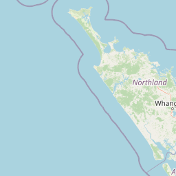
Use this park location map to pinpoint Waro Limestone Scenic Reserve in New Zealand, understand its exact geographic position, and read its mapped placement within the surrounding landscape more clearly.

Pigeon | © OpenStreetMap contributors

Explore protected limestone terrain, karst formations, and visual character

Waro Limestone Scenic Reserve Photos and Landscape Scenery Visual Guide

Visual records reveal the dramatic vertical limestone outcrops and weathering patterns that define Waro Limestone Scenic Reserve. Photographic collections capture the distinct contrast between pale rock formations, surrounding pasture, and industrial heritage remnants across the protected landscape.

A black and white archival photograph of the tall, jagged, and weathered limestone formation known as Cathedral Rock at Waro.

A black and white archival photograph of tall, weathered limestone rock towers standing in an open field with sparse vegetation.

Park atlas

Compare regional park geography and connected geological reserves across Northland

Explore Parks Near Waro Limestone Scenic Reserve and Surrounding Protected Landscapes

Browsing other parks near Waro Limestone Scenic Reserve reveals broader geological diversity across the surrounding Northland countryside. Comparing nearby protected landscapes helps contextualize local karst formations within regional conservation geography.
A pale, minimalist watercolor painting depicting soft green and pink hilly island silhouettes rising from a calm, white-toned sea.
Marine protected areaNew Zealand
About 37 km away#1 closest

East

Poor Knights Islands Marine Reserve: Geography and Marine Protected Area Atlas

Exploring coastal cliffs and underwater volcanic terrain

The Poor Knights Islands Marine Reserve encompasses a protected 1,890 hectare marine environment renowned for its steep underwater walls and tunnel systems. Located off the coast of New Zealand, this reserve serves as a critical study area for marine conservation and ecosystem recovery. Explore the geological features, including the Northern Arch and rugged offshore rock stacks, which distinguish this maritime landscape.

Area
18.9 km²
Established
1981
Access
Access unknown
Scope
Marine
Nature reserveNorthland Region
About 43 km away#2 closest

East

Poor Knights Islands Nature Reserve: Mapped Volcanic Geography and Protected Coastal Landscapes

A rugged island chain offshore from New Zealand's Northland Region.

The Poor Knights Islands serve as an essential protected landscape characterized by sheer volcanic cliffs, natural arches, and extensive sea cave systems. Rising sharply from the sea, these uninhabited islands function as a vital sanctuary for seabirds and native flora, providing a unique look into the deeply eroded remnants of ancient rhyolitic volcanic activity within New Zealand.

Area
2.714 km²
Established
1975
IUCN
Ia
Relief
Upland
A watercolor illustration of a soft green hilly landscape with distant peaks against a white background.
Nature reserveNew Zealand
About 56 km away#3 closest

Southeast

Hen and Chicken Islands Nature Reserve: Mapped Geography and Protected Island Terrain

Archipelago sanctuary and volcanic landscape offshore of New Zealand

Explore the geographic structure of the Hen and Chicken Islands, an uninhabited nature reserve that serves as a vital predator-free sanctuary. The archipelago displays varied volcanic terrain, from the dramatic central ridge of Hen Island to the rugged rocky reefs of the Marotiri islets, offering a clear window into the ecological conservation landscapes of the Northland region.

Area
8.44 km²
Established
1908
Relief
Highland
Climate
Subtropical
Nature reserveNorthland Region
About 62 km away#4 closest

Southwest

Kai Iwi Lakes Reserve: A Detailed Look at Northland's Freshwater Dune Lake Geography

Nature reserve featuring dune-formed lake basins and native scrub

Kai Iwi Lakes Reserve is a notable nature reserve in the Northland region, centered on the freshwater lakes of Taharoa, Kaiiwi, and Waikare. This protected area offers insight into sand-sculpted geomorphology, with lake basins formed by windblown dunes and surrounded by a diverse mix of native forest, pine stands, and pastoral land, providing a clear window into Northland's unique inland water geography.

Area
5.38 km²
Relief
Lowland
Climate
Temperate
Access
Moderate access
Regional parkAuckland Region
About 66 km away#5 closest

Southeast

Te Ārai Regional Park: Mapping Coastal Dune Systems and Protected Geography in Auckland

A protected coastal landscape featuring expansive dune systems and northern headlands.

Te Ārai Regional Park sits as a major protected coastal area on the northern edge of the Auckland Region. Its primary defining feature is an expansive system of sand dunes that anchor a diverse coastal environment. Extending southward toward Poutawa Stream and bordered by the Mangawhai Forest, the park represents a critical geography for endangered species breeding and provides a distinct topographic profile along the North Island coast.

Established
2008
Relief
Lowland
Climate
Subtropical
Access
Easy access
Nature reserveNew Zealand
About 67 km away#6 closest

West

Waipoua Forest Nature Reserve: An Atlas of Ancient Kauri and Northland Rainforest

Charting the protected ecological boundaries and humid temperate geography

Waipoua Forest represents a vital protected landscape in Northland, New Zealand, characterized by deep, rain-fed valleys and towering kauri stands. This nature reserve sustains one of the largest clusters of old-growth trees in the country, maintaining a dense, multi-layered forest structure that stands in sharp contrast to the modified land on its margins. The sanctuary remains a primary reference point for understanding the wet, hilly terrain of the North Island west coast.

Area
80 km²
Established
1952
Visitors
200K annual
Relief
Upland
A watercolor painting showing a soft, bright landscape with green grasses and wildflowers on both sides of a calm, pale blue body of water, with a green coastline in the distance.
Marine protected areaNew Zealand
About 86 km away#7 closest

Southeast

Cape Rodney-Okakari Point Marine Reserve: New Zealand Marine Protected Area Geography

Mapped coastal boundaries and marine ecosystem terrain

Delve into the geography of Cape Rodney-Okakari Point Marine Reserve, where protected waters meet a complex interface of greywacke bedrock and sandy substrates. This assessment highlights the ecological transition from exposed rocky headlands to sheltered Whangateau Harbour, illustrating the structural depth of New Zealand's foundational marine site through its diverse invertebrate and fish habitats.

Area
5.5 km²
Established
1975
IUCN
Ia
Visitors
200K annual
Regional parkAuckland Region
About 99 km away#8 closest

South

Te Rau Pūriri Regional Park: Geography and Protected Land Overview for Auckland Region

Coastal harbour landscape and native forest recovery zones

Te Rau Pūriri Regional Park occupies a strategic position on the South Kaipara Head, serving as a protected corridor between agricultural land and the expansive Kaipara Harbour. The park serves as an atlas-worthy example of ecological transition, featuring sandy bays, eucalyptus stands, and native pūriri forests that provide habitat stability within the wider Auckland coastal geography.

Area
2.49 km²
Established
2006
Relief
Lowland
Climate
Temperate

Common questions about visiting, size, designation, and location context for Waro Limestone Scenic Reserve

Waro Limestone Scenic Reserve FAQs for park facts, access, geography, and protected area context

Find quick answers about Waro Limestone Scenic Reserve, including protected-area facts, park geography, trail and visitor context, and how the park fits into its surrounding country and regional landscape.
MoriAtlas Explorer

Continue Your Protected Areas Search Across the Global Atlas

Deepen your exploration by continuing the structured search for national parks and protected areas worldwide. Utilize the comprehensive filtering capabilities to compare different conservation landscapes and refine your understanding of global park geography. Discover more about the distribution and characteristics of protected natural areas.

Global natural geography