Mori Atlas logo
National parkKarthala National Park

Discover the unique geography, mapped boundaries, and endemic biodiversity of this active volcano in the Comoros.

Karthala National Park: Comoros' Volcanic Shield Volcano and Protected Landscape

(Parc National du Karthala)

Karthala National Park, located on Grande Comore island in the Comoros archipelago, represents a significant protected natural area centered around the active shield volcano Mount Karthala. This national park encompasses dramatic volcanic terrain, rising to the highest point in Comoros, and is vital for preserving a unique island ecosystem and exceptional levels of endemic species. Its protected landscape offers a prime example of volcanic geography and serves as a crucial component of the region's natural heritage.

Volcanic landscapeEndemic biodiversityProtected areaIsland ecosystemBirdwatchingRamsar site

Karthala National Park

National park

Park overview

Structured park overview, official facts, and landscape profile for Karthala National Park

Karthala National Park park facts, protected area profile, and essential visitor context

Review the core facts for Karthala National Park, including designation, size, terrain, visitor scale, habitats, and operating context in one park-focused overview.

About Karthala National Park

Karthala National Park represents Comoros' primary protected area for highland volcanic ecosystems and endemic biodiversity. The park occupies the southern and larger portion of Grande Comore, the largest island in this Indian Ocean archipelago nation. Mount Karthala itself is a shield volcano that dominates the island's landscape, rising dramatically from the coast to its summit at 2,361 meters. The volcano's frequent eruptions have shaped a distinctive caldera environment, with the most recent significant activity occurring in 2005 and 2006. These eruptions have modified the summit crater, eliminating a crater lake that had formed after the 1991 eruption and leaving exposed rock and volcanic debris within the caldera. The park's establishment in 2010 reflected Comoros' commitment to preserving this unique combination of geological processes and ecological communities that exist at the island's highest elevation.

Quick facts and research context for Karthala National Park

Karthala National Park occupies the volcanic heights of Mount Karthala on Grande Comore island in the Comoros archipelago. The park was established in 2010 by the Comoros National Parks Authority and covers 26,214 hectares of terrain surrounding a 2,361-meter active shield volcano. The mountain features a prominent caldera approximately 3 kilometers by 4 kilometers in size, formed through centuries of volcanic activity. The area was designated a Ramsar Wetland site in 2006, recognizing its ecological significance. The park contains intact moist evergreen forest between 1,200 and 1,800 meters elevation, transitioning to heathland and stunted vegetation near the summit.

Protection and recognition

Analyzing terrestrial conservation boundaries and the formal establishment timeline for the reserve

Karthala National Park Protection Status and Official Designation History

Researchers can verify the formal terrestrial protection status and administrative records associated with Karthala National Park, which was officially designated in 2010. Evaluating documented conservation frameworks provides essential geographic context for understanding the long term management profile of the regional landscape.

Protection details

Protection scope
Terrestrial
Designated year
2010
Transboundary protection
No
Park context

Deeper park guide and search-rich context for Karthala National Park

Karthala National Park history, landscape, wildlife, and travel context

Explore Karthala National Park through its history, landscape character, ecosystems, wildlife, conservation priorities, cultural context, and seasonal travel timing in a structured park guide built for atlas discovery and search intent.

Why Karthala National Park stands out

Karthala National Park is best known for protecting the highest peak in Comoros, an active volcanic mountain with a dramatic caldera system. The park is particularly significant for its extraordinary endemism, supporting four bird species found exclusively on Mount Karthala's slopes: the Grand Comoro drongo, Humblot's flycatcher, Karthala scops owl, and Karthala white-eye. The mountain's moist evergreen forest and heathland zones harbor unique plant species including the giant heather Erica comorensis. The park also protects a Ramsar-designated wetland area, distinguishing it as a site of international conservation importance.
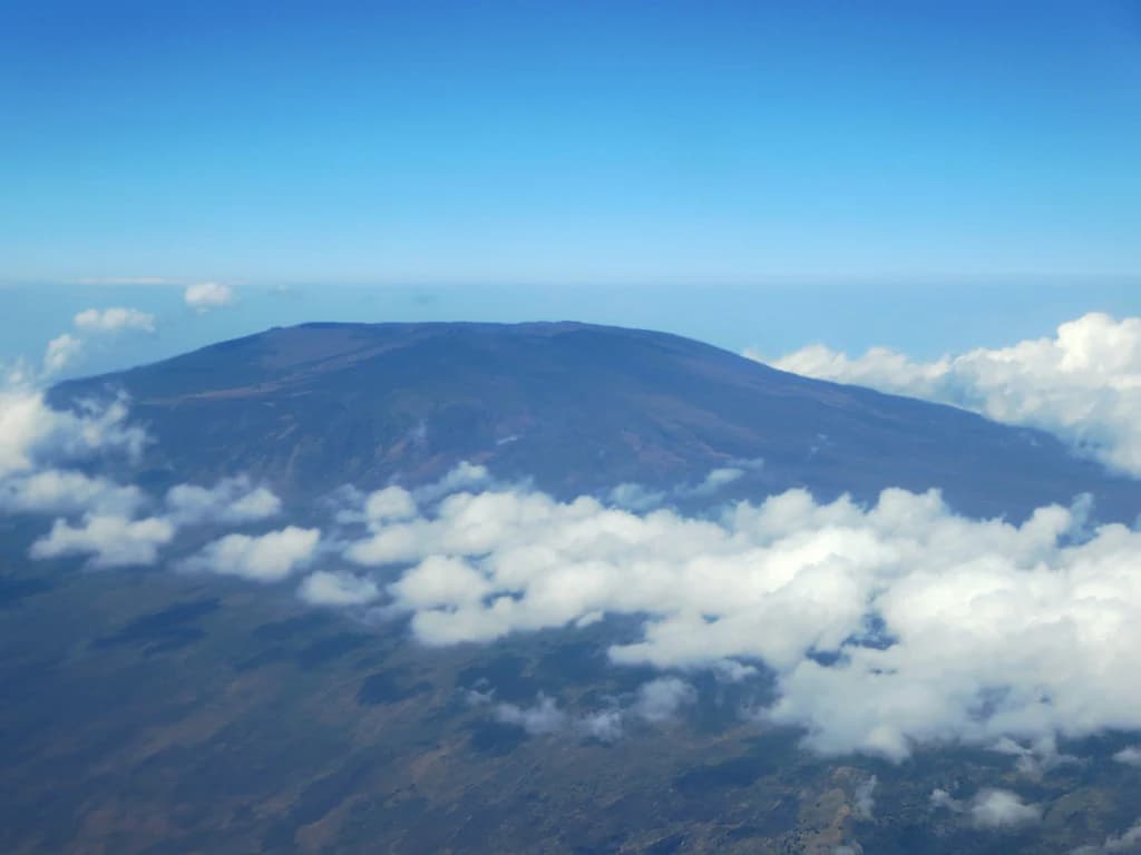
Aerial view of Mount Karthala with clouds surrounding the mountain peak

Karthala National Park history and protected-area timeline

Mount Karthala has a documented history of volcanic activity spanning more than a century, with over twenty eruptions recorded since the 19th century. The mountain's significance as a natural landmark and ecological area led to the designation of a Ramsar Wetland site covering 14,228 hectares in November 2006, recognizing the importance of the upper slopes and summit area. Karthala National Park was officially established in 2010 through the Comoros National Parks Authority, formalizing protection for the volcano and its surrounding ecosystems. The 2005 eruption caused significant changes to the summit crater, forcing the evacuation of approximately 2,000 residents and resulting in the loss of the crater lake that had become a notable feature of the caldera. Subsequent activity in 2006 produced visible lava discharge observable from the capital Moroni, though the volcanic material remained confined to the summit area.

Karthala National Park landscape and geographic character

The landscape of Karthala National Park is defined by the dramatic volcanic landforms of Mount Karthala, an active shield volcano forming the southern portion of Grande Comore island. The mountain rises from sea level to 2,361 meters at its summit, creating a sloping volcanic mass with the characteristic gentle profiles typical of shield volcanoes. A prominent caldera measuring approximately 3 kilometers by 4 kilometers occupies the summit region, the result of repeated volcanic activity that has collapsed and reshaped the crater over centuries. The terrain within the park encompasses steep upper slopes, exposed volcanic rock within the caldera, and the dense forest cover that characterizes the mid-elevation zones. The landscape transitions from agricultural zones at lower elevations through the forested mid-slopes to heathland and bare volcanic rock near the summit.

Karthala National Park ecosystems, habitats, and plant life

The ecological character of Karthala National Park is shaped by the mountain's elevation gradient and isolated island position in the Mozambique Channel. Below approximately 1,200 meters, the mountain transitions from human-modified landscapes to intact moist evergreen forest that extends to about 1,800 meters elevation. This cloud forest zone supports dense vegetation adapted to the persistent moisture from the mountain's interaction with oceanic weather patterns. Above the forest line, the vegetation transitions to stunted trees and heathland where the giant heather Erica comorensis forms a distinctive component of the summit-zone flora. The isolation of the Comoros archipelago has driven significant evolutionary divergence, resulting in numerous species found only on these islands. The forest ecosystem faces threats from logging and agricultural expansion that encroach upon the park's boundaries.

Karthala National Park wildlife and species highlights

Karthala National Park is significant for its unique avifauna, with four bird species endemic to Mount Karthala's slopes. These include the Grand Comoro drongo, Humblot's flycatcher, Karthala scops owl, and Karthala white-eye, each occupying specific habitat zones within the mountain's forests and heathlands. The broader Important Bird Area designated by BirdLife International encompasses 14,228 hectares and supports additional restricted-range species including the Comoros blue pigeon, Comoros olive pigeon, Grand Comoro bulbul, and Humblot's sunbird. The mountain also supports populations of Comoros thrushes, Grand Comoro brush warblers, and Malagasy harriers. The forest and heathland habitats provide feeding and nesting grounds for these species, though the isolated nature of the ecosystem makes the avifauna particularly vulnerable to environmental changes.

Karthala National Park conservation status and protection priorities

Karthala National Park serves as a critical conservation area for Comoros, protecting the nation's highest elevation terrain and its associated endemic species. The park's Ramsar designation in 2006 acknowledged the international significance of the wetland areas within the volcano's summit region. The Important Bird Area status awarded to the upper slopes reflects the global importance of protecting populations of restricted-range species that occur nowhere else. The Comoros National Parks Authority administers the protected area, working to preserve the unique combination of volcanic landscape, forest ecosystems, and endemic biodiversity. Conservation challenges include the threat of logging and agricultural expansion that pressures the forest boundaries, as well as the inherent risks associated with protecting an active volcanic area.

Karthala National Park cultural meaning and human context

Mount Karthala holds cultural significance for the people of Grande Comore, with the Arabic name Al Qirṭālah reflecting the mountain's place in local toponymy. The volcano's prominent position relative to Moroni, the capital located on the island's western coast, means the mountain forms a visible backdrop to daily life for many Comorians. The periodic volcanic activity, including the evacuations required during the 2005 and 2006 eruptions, demonstrates the ongoing relationship between the local population and this natural phenomenon. The mountain's forest resources and water catchment functions also hold traditional importance for surrounding communities, though the formal protected area status now guides management of these resources.

Top sights and standout views in Karthala National Park

Karthala National Park offers access to the highest point in Comoros, where visitors can explore the volcanic landscapes of an active shield volcano with a dramatic summit caldera. The endemic birdlife represents one of the park's most remarkable features, with four species found nowhere else on Earth. The moist evergreen forest zone between 1,200 and 1,800 meters provides a distinctive ecological experience, transitioning to unique heathland environments near the summit where giant heather creates unusual vegetation patterns. The park's Ramsar wetland designation acknowledges the ecological importance of the highland water systems, even as volcanic activity continues to reshape the summit environment.

Best time to visit Karthala National Park

The best time to explore Karthala National Park corresponds to the dry season in Comoros, typically spanning from May through October. During these months, precipitation is reduced and visibility improves, allowing for clearer views from the summit across the archipelago. The dry season also makes hiking conditions more favorable, with less muddy terrain on the forest trails. However, visitors should be aware that the mountain's weather can change rapidly due to its elevation and exposure, with cloud cover and brief showers possible even during generally dry periods. The volcano's active status means that any visit should incorporate current safety guidance from local authorities regarding volcanic activity levels.
Monthly climate preview

Long-term monthly temperature and precipitation patterns recorded for Karthala National Park

Karthala National Park Climate Normals, Annual Temperature and Precipitation Rhythm

Historical climate data reveals measured monthly temperature ranges alongside shifting precipitation rates across the representative point of Karthala National Park. Detailed monthly breakdowns provide deeper insight into long-term averages for sustained geographical research.
Annual mean27 °C
25 °C28 °C
Jan28°
Feb28°
Mar28°
Apr28°
May27°
Jun26°
Jul25°
Aug25°
Sep25°
Oct26°
Nov27°
Dec28°
Warmest month
March

28.1 °C

Coolest month
August

24.7 °C

Wettest month
January

6.9 mm/day

Driest month
September

0.6 mm/day

Park location guide

Geography guide, regional context, and park location map for Karthala National Park

Karthala National Park park geography, regions, and map view in Comoros

Understand where Karthala National Park sits in Comoros through a broader geographic reading of the surrounding landscape, nearby location context, and its mapped position within the national park landscape.

How Karthala National Park fits into Comoros

Comoros is an island nation in the Indian Ocean located at the northern end of the Mozambique Channel. It consists of three main islands: Grande Comore, Anjouan, and Mohéli. The country gained independence from France in 1975 and is a member of the Arab League, African Union, and Organisation of Islamic Co-operation. It has three official languages: Comorian, French, and Arabic.

Wider geography shaping Karthala National Park in Comoros

Comoros is situated in the Indian Ocean at the northern end of the Mozambique Channel, between Madagascar and the African mainland. The country consists of three main volcanic islands: Grande Comore, Anjouan, and Mohéli. The islands are part of the Comoro Islands archipelago.

Map view of Karthala National Park

Use this park location map to pinpoint Karthala National Park in Comoros, understand its exact geographic position, and read its mapped placement within the surrounding landscape more clearly.

Pigeon | © OpenStreetMap contributors

Explore the unique volcanic terrain, endemic habitats, and dramatic caldera views of this Comoros national park.

Karthala National Park Photos, Landscapes, and Protected Area Scenery

Explore a visual atlas of Karthala National Park, revealing its dramatic volcanic landscapes, unique forest habitats, and exposed alpine terrain. These images offer an essential visual context, helping you understand the distinctive protected area character, ecological significance, and the active shield volcano environment of Mount Karthala.

Aerial view of Mount Karthala with clouds surrounding the mountain peak

Large volcanic crater with layered rock formations, rocky terrain, and a flat central basin under partly cloudy sky

Park atlas

Trace protected landscapes and regional park geography surrounding Karthala National Park, Comoros.

Discover Other National Parks and Protected Areas Near Karthala National Park

After exploring Karthala National Park, continue your geographic discovery by browsing other national parks and protected areas in the surrounding regions. Compare diverse protected landscapes, volcanic terrain, and island ecosystems to understand the broader conservation efforts and unique natural features of the Comoros archipelago and beyond.
National parkGrande Comore
About 11 km away#1 closest

Southwest

Coelacanth National Park: Marine Protected Landscape and Geographic Setting off Grande Comore

Explore the unique marine geography and conservation value.

Coelacanth National Park is a significant marine protected area dedicated to preserving a unique underwater ecosystem surrounding Grande Comore. Its designation as a national park highlights its importance for safeguarding the habitat of the coelacanth, a rare prehistoric fish species. The park's landscape comprises vibrant coral reefs and deep offshore waters, integral to the broader Indian Ocean geography, offering insights into marine conservation and protected areas.

Area
92.76 km²
Established
2010
IUCN
II
Scope
Marine
National parkComoros
About 64 km away#2 closest

Southeast

Mohéli National Park: Comoros National Park and Protected Landscape Exploration

Mapped geography and protected area identity.

Mohéli National Park is a dedicated national park within the Comoros, providing a specific focus for exploring protected lands and their geographic distribution. This entry details the park's mapped boundaries and its significance as a conservation landscape. Understanding Mohéli National Park offers valuable insight into the regional geography of the Comoros archipelago and its unique natural context.

Area
643.62 km²
Established
2010
Relief
Mixed relief
Climate
Tropical
National parkAnjouan
About 103 km away#3 closest

Southeast

Shisiwani National Park: Anjouan's Protected Marine and Island Landscape Atlas

Coastal and terrestrial protected area mapping in Comoros.

Delve into the protected landscape of Shisiwani National Park, a critical national park situated on Anjouan's Sima Peninsula in Comoros. This atlas entry details the park's combined marine and terrestrial boundaries, highlighting its vital coral reefs, mangrove forests, and unique island geography. Understand the park's role in conservation through its mapped extent and diverse natural environments, offering a clear geographic context for protected area exploration.

Area
64.97 km²
Established
2016
IUCN
II
Climate
Tropical
Watercolor illustration of a mountainous landscape with a lake and grassy fields.
National parkAnjouan
About 127 km away#4 closest

Southeast

Mount Ntringui National Park: Protected Volcanic Landscape and Highland Geography on Anjouan

Explore its dramatic peaks, crater lake, and remnant montane forests.

Mount Ntringui National Park is a significant protected area situated in the rugged volcanic highlands of Anjouan. This national park preserves the island's highest peaks, Mount Ntringui and Mount Trindrini, alongside the unique Dzialandzé crater lake and the crucial Moya Forest. It stands as a vital refuge for endemic species and represents the last substantial tract of montane forest on Anjouan, offering deep insights into the region's unique ecology and mapped natural terrain.

Area
79.14 km²
Established
2010
IUCN
II
Relief
Mountain
Wildlife reserveMayotte
About 230 km away#5 closest

Southeast

Baie de Bouéni Wildlife Reserve: Mapping Coastal Biodiversity and Volcanic Terrain

A protected bay and mangrove system on the coast of Mayotte.

Baie de Bouéni stands as a significant wildlife reserve in Mayotte, framed by the volcanic massifs of Mont Bénara and Mont Choungui. This coastal sanctuary protects the largest mangrove belt in the Comoros and offers a clear example of the meeting of intertidal mudflats and marine ecosystems within the western Indian Ocean.

Area
5.19 km²
Established
2007
IUCN
IV
Relief
Lowland
Nature reserveMayotte
About 236 km away#6 closest

Southeast

Vasière des Badamiers: Mapping the Protected Coastal Wetlands of Petite-Terre

Nature reserve geography and intertidal ecosystem character

Vasière des Badamiers is an essential protected coastal wetland in Mayotte, characterized by its tidal mudflats and mangrove fringes. This site acts as a key migratory refuge for waterbirds while functioning as a natural filter for the surrounding lagoon. Use this data to analyze the unique brackish basin and the ecological boundaries that define this Ramsar-recognized environment.

Area
1.25 km²
Established
2002
IUCN
IV
Protected areaMayotte
About 238 km away#7 closest

Southeast

Pointes et plages de Saziley et Charifou Protected Area Geography and Map Context

Coastal ridgelines, mangrove habitats, and Mayotte island terrain

Delve into the physical geography and protected area configuration of Pointes et plages de Saziley et Charifou. This site presents a striking contrast between steep, dry inland ridges and low-lying coastal mangrove systems, offering an essential look at the complex environmental layering found across the southeastern coast of Mayotte.

Area
6.65 km²
Established
1997
IUCN
IV
Relief
Upland
National parkCabo Delgado Province
About 321 km away#8 closest

West

Quirimbas National Park: Coastal Protected Landscape and Island Archipelago Atlas

Discover marine conservation and inselberg terrain in Cabo Delgado.

Quirimbas National Park, located in Cabo Delgado Province, Mozambique, is a key protected area defined by its exceptional combination of marine and terrestrial environments. The park's geography includes eleven islands, extensive mangrove forests, and vibrant coral reefs, alongside a mainland characterized by striking inselberg formations. This national park is a vital site for understanding coastal landscape diversity, marine ecosystems, and protected-area geography within East Africa.

Area
1,430 km²
Established
1971
IUCN
II
Relief
Mixed relief

Common questions about visiting, size, designation, and location context for Karthala National Park

Karthala National Park FAQs for park facts, access, geography, and protected area context

Find quick answers about Karthala National Park, including protected-area facts, park geography, trail and visitor context, and how the park fits into its surrounding country and regional landscape.
MoriAtlas Explorer

Continue Your Protected Areas Search Across the Global Atlas

Deepen your exploration by continuing the structured search for national parks and protected areas worldwide. Utilize the comprehensive filtering capabilities to compare different conservation landscapes and refine your understanding of global park geography. Discover more about the distribution and characteristics of protected natural areas.

Global natural geography