Mori Atlas logo
National parkKytalyk National Park

Examining the permafrost plains and wilderness boundaries of this remote Sakha Republic habitat

Kytalyk National Park: An In-Depth Look at Protected Arctic Tundra and Wetland Geography

Kytalyk National Park preserves a massive, treeless expanse of East Siberian tundra deep within the Sakha Republic. This protected landscape is defined by a complex mosaic of polygon mires, meandering river valleys, and thousands of seasonal thaw lakes. The terrain serves as a critical breeding ground for rare waterfowl and arctic species, offering a rare window into the ecology of the harsh, wind-sculpted permafrost zone.

Arctic tundrapermafrostthaw lakesSiberian cranebird breeding groundswaterfowl

Kytalyk National Park

National park

Park overview

Structured park overview, official facts, and landscape profile for Kytalyk National Park

Kytalyk National Park park facts, protected area profile, and essential visitor context

Review the core facts for Kytalyk National Park, including designation, size, terrain, visitor scale, habitats, and operating context in one park-focused overview.

About Kytalyk National Park

Kytalyk National Park lies in the far north of Yakutia, in the district of Allaikha, where the continental Arctic coast gives way to broad expanses of tundra stretching toward the Laptev Sea. The park sits within one of the coldest and most sparsely populated regions of the Eurasian continent, yet it is ecologically rich, defined by permafrost soils, seasonal wetlands, and a tight annual rhythm of life driven by the extreme Arctic climate.

The creation of Kytalyk as a national park in late 2019 was a direct response to the urgent need to consolidate and strengthen protection around a key breeding area for the eastern population of the Siberian crane. By absorbing the most important parts of the earlier Kytalyk wildlife sanctuary and a local resource reserve, the park brought together several overlapping categories of protection under a single, nationally managed framework, improving both legal clarity and on-the-ground conservation capacity.

Ecologically, the park is a textbook example of East Siberian Arctic tundra. Low-lying terrain, polygonal tundra, sedge and moss mires, and countless shallow lakes dominate the landscape. These conditions are vital for breeding and moulting waterbirds, and they create a complex mosaic of microhabitats that supports an unusually rich tundra avifauna. The combination of vast open space, low human pressure, and intact habitat has made Kytalyk a focal site for international crane research, waterbird monitoring, and Arctic ecosystem studies.

For visitors, Kytalyk is far from a conventional national park experience. Access is extremely limited, tourism infrastructure is minimal, and the park's value is primarily scientific and conservation-oriented rather than recreational. Its importance lies not in visitor amenities but in what it preserves: an intact stretch of one of the world's most threatened Arctic ecosystems and a vital refuge for a species whose future depends almost entirely on the survival of places like this.

Quick facts and research context for Kytalyk National Park

Kytalyk National Park is a federal protected area in the Allaikha district of Yakutia, in the Russian Far East. Founded on 24 December 2019, it covers a very large Arctic tundra territory and merges the most valuable parts of the earlier Kytalyk zakaznik and a local resource reserve. Its primary management objective is safeguarding the breeding habitat of the eastern population of the Siberian crane, listed in the Russian Red Book as a rare species and internationally as threatened with extinction.

Protection and recognition

Examine terrestrial protected area status and official conservation records

Kytalyk National Park Protection Status and International Recognition

Kytalyk National Park maintains a documented terrestrial protection scope within its regional conservation framework. Official records compile management parameters and designated area status for accurate geographical analysis.

Protection details

Protection scope
Terrestrial
Transboundary protection
No
Park context

Deeper park guide and search-rich context for Kytalyk National Park

Kytalyk National Park history, landscape, wildlife, and travel context

Explore Kytalyk National Park through its history, landscape character, ecosystems, wildlife, conservation priorities, cultural context, and seasonal travel timing in a structured park guide built for atlas discovery and search intent.

Why Kytalyk National Park stands out

Kytalyk is primarily known as one of the last and most important breeding grounds of the eastern Siberian crane, a species that has been brought to the edge of extinction by habitat loss and hunting across its flyway. The tundra wetlands of the park support the cranes' nesting and chick-rearing stages during the brief Arctic summer, making the area globally significant for the long-term survival of the species. The park is equally recognized for its exceptionally intact East Siberian tundra landscapes, including thaw-lake plains, polygon mires, and riverine habitats that sustain a wide range of Arctic birds and mammals. Its tentative inscription on the UNESCO World Heritage list further underlines its profile as a benchmark Arctic wilderness of international conservation value.
Kytalyk National Park history and protected-area timeline

The territory that now forms Kytalyk National Park has a long conservation history preceding its current national park status. The area began to receive formal protection as the Kytalyk state wildlife sanctuary (zakaznik), created to safeguard breeding habitat for the endangered eastern Siberian crane, and was later supplemented by a local resource reserve of regional significance.

These overlapping protection categories reflected growing awareness of the ecological importance of the site, particularly its role for Siberian cranes and other Arctic-breeding birds, but they also produced fragmented governance and inconsistent management. On 24 December 2019, the Russian Federation formally established Kytalyk National Park by merging the most valuable parts of the earlier sanctuary and resource reserve into a single federally managed protected area.

The park's founding was widely regarded as a major step for Arctic conservation in Russia. It placed the long-term protection of the Siberian crane's breeding grounds on a stronger institutional footing and brought the territory into international conservation frameworks, including placement on the UNESCO World Heritage tentative list.

Kytalyk National Park landscape and geographic character

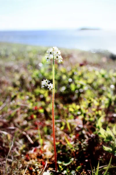
The landscape of Kytalyk is shaped by the immense, low-relief tundra plains that dominate much of northeastern Yakutia. Permafrost underlies virtually the entire territory, producing the classic surface features of Arctic tundra: polygonal ice-wedge terrain, sedge and moss mires, and a network of shallow thaw lakes that flood and drain with the seasons.

Rivers and streams meander across the plains in broad, often poorly defined valleys, creating wetland transitions between drier upland tundra and waterlogged lowlands. These mosaic landscapes, punctuated by lakes of every size, give the park its deeply varied but visually unified character. In the brief Arctic summer, the tundra blooms with moisture-loving grasses, sedges, and wildflowers, while winter transforms the terrain into a vast, white, wind-sculpted expanse.

Because the region sits inland from the coast yet remains firmly within the Arctic climate zone, summers are short, cool, and biologically intense, while winters are among the harshest in the Northern Hemisphere. The terrain is essentially treeless, with vegetation limited to low tundra plants, and the horizon is typically broken only by distant river bluffs, lake margins, or changing weather, giving the park a strongly open, contemplative character.

Kytalyk National Park ecosystems, habitats, and plant life

Kytalyk protects a representative sample of East Siberian Arctic tundra, one of the world's most climate-sensitive ecosystems. The dominant habitats are moist and dry tundra, polygonal mires, sedge meadows, and the vast thaw-lake complexes that define much of the region's surface hydrology. These habitats together support a high density of breeding, moulting, and staging waterbirds during the short productive season.

Flora in the park is characteristic of the subarctic: low-growing vascular plants, mosses, lichens, and hardy graminoids adapted to permafrost soils and a very short growing season. According to surveys, at least 273 species of vascular plants have been documented in the park's territory, including several rare and regionally significant species such as Rhodiola rosea and other tundra specialists with restricted distributions in Yakutia.

Ecological processes in Kytalyk are tightly linked to permafrost stability and seasonal hydrology. The thaw cycle each year reworks the surface, while the wetlands filter nutrients and support the aquatic invertebrate communities on which breeding birds depend. The intactness of these processes is a key reason the park has become a reference site for Arctic ecosystem research and for understanding the long-term resilience of tundra under climate change.

Kytalyk National Park wildlife and species highlights

Kytalyk's wildlife profile is dominated by birds. The park hosts at least 91 bird species, of which 63 are known to breed within its territory. Among the most important are the Siberian crane, white-billed loon, lesser white-fronted goose, Bewick's swan, the spotted greenshank-adjacent species known as the spotted greenshank group, the spectacled duck called the kloktun, the gyrfalcon, and the peregrine falcon. The wetlands also support large concentrations of moulting waterfowl during the post-breeding season.

The mammal fauna is typical of the East Siberian tundra, though relatively species-poor compared to boreal regions. Documented species include wolf, Arctic fox, wolverine, muskrat, and various rodents. Larger mammals such as wild reindeer, moose, Siberian weasel (ermine), least weasel, brown bear, and muskox visit or move through the park more intermittently, using it as part of much wider Arctic home ranges.

The flagship of Kytalyk's wildlife is unmistakably the Siberian crane. The eastern population, which migrates between Yakutia and wintering sites in China, depends almost entirely on a very small number of safe breeding territories, and the park hosts one of those key refuge areas. Protecting this crane population has shaped both the park's boundaries and its overall management priorities.

Kytalyk National Park conservation status and protection priorities

Kytalyk's conservation significance operates at multiple scales. At a national level, it is a core protected area within Russia's system of nature reserves and national parks, providing formal protection for species listed in the Russian Red Book, including the Siberian crane. At an international level, it supports a species whose survival depends on coordinated action across several countries along the East Asian flyway.

The park also has strong scientific conservation value. Its intact tundra ecosystems serve as a baseline for studying climate change impacts, permafrost dynamics, and shifts in Arctic biodiversity. The presence of breeding Siberian cranes, white-billed divers, and lesser white-fronted geese gives the site high relevance for global waterbird monitoring programs and for flyway-scale conservation planning.

In recognition of its outstanding values, Kytalyk National Park was included in the tentative list of UNESCO World Heritage sites, signaling international recognition of its natural significance. Continued conservation effort focuses on habitat protection, anti-poaching, monitoring of key species, and minimizing disturbance to breeding birds during the most sensitive summer months.

Kytalyk National Park cultural meaning and human context

The Kytalyk region lies within the traditional territory of northern Yakut (Sakha) peoples and indigenous communities of the Russian Arctic, for whom the tundra has long been a landscape of hunting, fishing, reindeer husbandry, and seasonal movement. The place name itself is of Yakut origin, reflecting long-standing local familiarity with the area.

In the modern administrative context, the park falls within the Allaikha district, an area historically organized around small tundra settlements and a way of life shaped by the extreme climate and distance from major population centers. The creation of Kytalyk National Park reflects a growing recognition, both in Russia and internationally, of the importance of protecting intact Arctic landscapes where indigenous land-use practices and modern conservation priorities continue to intersect.

Top sights and standout views in Kytalyk National Park

Kytalyk's defining highlights are its globally important breeding population of the Siberian crane and its exceptionally intact East Siberian tundra mosaic of thaw lakes, polygon mires, and sedge wetlands. Among its most notable features are breeding sites for white-billed divers, lesser white-fronted geese, and Bewick's swans, along with large seasonal concentrations of moulting waterfowl.

Equally important is the park's role as a reference site for Arctic conservation science and its recognition on the UNESCO World Heritage tentative list, which together mark it as a benchmark of both national and international natural significance.

Best time to visit Kytalyk National Park

The window for meaningful access to Kytalyk is extremely narrow, limited to the brief Arctic summer. Late June through August is the season when the tundra thaws, wildlife is most active, and migratory birds, including Siberian cranes, are present on their breeding grounds. This is also when waterfowl masses concentrate for moult at the park's thaw lakes.

Outside this short window, conditions become extraordinarily harsh, with prolonged extreme cold, polar night, and effectively no biological activity. The park's isolation, lack of developed visitor infrastructure, and sensitivity of breeding wildlife mean that any visit must be carefully planned, low-impact, and ideally tied to scientific or conservation work rather than conventional tourism.

Monthly climate preview

Long-term temperature and precipitation measurements across twelve monthly intervals

Kytalyk National Park Climate Normals and Annual Weather by Month

Kytalyk National Park records long-term average temperatures spanning from deep winter lows to positive summer highs alongside measured monthly precipitation rates. Detailed climate normals provide a complete chronological breakdown of temperature and moisture variations across the protected terrain.
Annual mean-13 °C
-33 °C8 °C
Jan-33°
Feb-32°
Mar-25°
Apr-14°
May-4°
Jun
Jul
Aug
Sep
Oct-12°
Nov-24°
Dec-31°
Warmest month
July

8.5 °C

Coolest month
January

-32.9 °C

Wettest month
July

2.1 mm/day

Driest month
January

0.4 mm/day

Park location guide

Geography guide, regional context, and park location map for Kytalyk National Park

Kytalyk National Park park geography, regions, and map view in Russia

Understand where Kytalyk National Park sits in Russia through a broader geographic reading of the surrounding landscape, nearby location context, and its mapped position within the national park landscape.

How Kytalyk National Park fits into Russia

Russia is a transcontinental nation spanning eleven time zones, bordered by fourteen countries. It is the world's largest country by area, covering 17,098,246 km². Moscow is the capital and largest city, while Saint Petersburg is the second-largest and a major cultural centre.

Wider geography shaping Kytalyk National Park in Russia

Russia spans Eastern Europe and North Asia, covering 17,098,246 km². It shares land borders with fourteen countries, more than any other nation, and spans eleven time zones. The landscape includes vast plains, mountain ranges such as the Urals and Caucasus, and extensive coastlines along the Arctic Ocean, Pacific Ocean, Baltic Sea, Black Sea, and Caspian Sea.

Map view of Kytalyk National Park

Use this park location map to pinpoint Kytalyk National Park in Russia, understand its exact geographic position, and read its mapped placement within the surrounding landscape more clearly.

Pigeon | © OpenStreetMap contributors

Location context for Kytalyk National Park

Sakha Republic
Park atlas

Discover surrounding Arctic wilderness areas and regional wetland sanctuaries

Parks Near Kytalyk National Park and Related Protected Landscapes to Compare

Compare Kytalyk National Park with other protected areas across the East Siberian tundra to understand regional conservation patterns. Broaden your geographic perspective by examining adjacent polar ecosystems and northern wetland habitats.
National parkSakha Republic
About 163 km away#1 closest

Southeast

Kytalyk National Park: Arctic Tundra Geography and Protected Siberian Wilderness

Exploration of permafrost terrain in the Sakha Republic

Situated in the Sakha Republic, Kytalyk National Park protects nearly 1.9 million hectares of low-lying Arctic coastal tundra. The park provides an essential look at intact polar environments, featuring thermokarst landforms, extensive peat bogs, and critical nesting grounds for migratory bird species across the Siberian landscape.

Area
18,856 km²
Established
2020
IUCN
II
Relief
Lowland
Watercolor illustration showing green hills, a river, and grassy foreground
Nature reserveSakha Republic
About 1,421 km away#2 closest

Southwest

Lena Pillars Nature Reserve: Mapped Protected Area in Sakha Republic's Vast Geography

Explore the regional landscape and park boundaries.

Discover Lena Pillars Nature Reserve, a key protected area located within the expansive Sakha Republic of Russia. This page offers focused atlas exploration, detailing the park's geographic setting and its mapped boundaries against the backdrop of Siberia's largest federal subject. Understand the unique natural landscape context and its significance within regional conservation efforts, providing structured geographic data for your exploration.

Area
13,870 km²
IUCN
II
Relief
Lowland
Climate
Subpolar
National parkSakha Republic
About 1,421 km away#3 closest

Southwest

Lena Pillars National Park: Geological Formations and River Geography in Sakha Republic

Explore the unique cliff-lined river corridors and boreal wilderness.

Lena Pillars National Park stands as a significant protected landscape in the Russian Far East. The area features a massive complex of vertical limestone towers rising from the Lena River, surrounded by permafrost-rich taiga forests and unique northern desert dunes. This geographic overview highlights the park terrain, river-based ecosystems, and the historical significance of the region.

Area
12,179.4 km²
Established
1994
IUCN
II
Relief
Highland
Stylized illustration of a mountainous coastline with rocky shore, calm water, and snow-capped peaks under a sky with clouds
National parkChukotka Autonomous Okrug
About 1,604 km away#4 closest

East

Beringia National Park: Arctic Tundra and Mountain Landscape Discovery in Chukotka

Explore protected boundaries and subarctic geographic features

Beringia National Park offers an expansive look at the subarctic ecosystems of the Chukchi Peninsula. This protected area preserves a unique terrain characterized by low-lying tundra plains and dramatic mountain ridges. Its position along the Bering Strait provides significant geographic context for understanding northern land connections and the remnants of ice age migrations within the Russian Arctic wilderness.

Area
30,532 km²
Established
2013
IUCN
II
Relief
Mixed relief
National parkChukotka Autonomous Okrug
About 1,876 km away#5 closest

East

Beringia National Park: Arctic Tundra and Coastal Protected Area in Chukotka

Geography of the Russian Far East and Bering Strait

Beringia National Park protects a sprawling network of Arctic tundra, dramatic shoreline, and isolated islands within the Chukotka Autonomous Okrug. The area maps the unique environmental transition between Siberia and the Bering Strait, highlighting a complex landscape of river basins and coastal cliffs that support diverse Arctic wildlife and migratory populations.

Area
18,194.5 km²
Established
1993
IUCN
II
Relief
Lowland
National parkKhabarovsk Krai
About 1,928 km away#6 closest

South

Shantar Islands National Park: Remote Archipelago Atlas with Rugged Terrain

Mapping protected marine and island geography in Khabarovsk Krai.

Shantar Islands National Park represents a significant protected landscape within Khabarovsk Krai, notable for its dramatic coastal geography, mountainous terrain, and rich marine ecosystems. This national park, encompassing a chain of islands in the Sea of Okhotsk, is a vital habitat for marine mammals and seabird colonies. Explore its mapped boundaries and unique regional atlas context, understanding its role as a protected coastal area in the Russian Far East.

Area
5,155 km²
Established
2013
IUCN
II
Relief
Mountain
National parkAmur Oblast
About 1,947 km away#7 closest

Southwest

Tokinsko-Stanovoy National Park: Protected Landscape Geography and Atlas Context

National Park in Amur Oblast, Russia

Delve into the specifics of Tokinsko-Stanovoy National Park, a designated national park within Amur Oblast. This entry provides essential context on its protected landscape characteristics and its place in the regional geography. Understand the park's mapped boundaries and discover its natural terrain as part of a larger atlas-driven exploration of protected areas in the Russian Far East.

Area
2,430 km²
Established
2019
IUCN
II
Relief
Mountain
Watercolor illustration of rolling green hills with distant mountains and a light sky
National parkRussia
About 2,019 km away#8 closest

Northwest

Russian Arctic National Park: Russia's Premier Northernmost Protected Landscape

Arctic Islands, Glacial Terrain, and Marine Mammal Habitats

Russian Arctic National Park preserves some of the planet's most remote and pristine Arctic environments across the Novaya Zemlya and Franz Josef Land archipelagos. This protected area offers unparalleled insight into Arctic geography, showcasing dramatic glacial landscapes, extensive seabird colonies, and critical feeding grounds for polar bears and bowhead whales. Explore the park's unique protected landscape and its significance within the broader atlas of global conservation efforts.

Area
14,260 km²
Established
2009
IUCN
II
Relief
Lowland

Common questions about visiting, size, designation, and location context for Kytalyk National Park

Kytalyk National Park FAQs for park facts, access, geography, and protected area context

Find quick answers about Kytalyk National Park, including protected-area facts, park geography, trail and visitor context, and how the park fits into its surrounding country and regional landscape.
MoriAtlas Explorer

Continue Your Protected Areas Search Across the Global Atlas

Deepen your exploration by continuing the structured search for national parks and protected areas worldwide. Utilize the comprehensive filtering capabilities to compare different conservation landscapes and refine your understanding of global park geography. Discover more about the distribution and characteristics of protected natural areas.

Global natural geography