Mori Atlas logo
National parkLadoga Skerries National Park

Discover the mapped boundaries and natural terrain of this national park in the Republic of Karelia.

Ladoga Skerries National Park: Protected Landscape and Regional Geography Atlas

Ladoga Skerries National Park stands as a significant protected area within the Republic of Karelia, offering a unique window into Russia's northern geography. This MoriAtlas page serves as your definitive guide to understanding the park's protected landscape, its distinct mapped boundaries, and its ecological context. Explore how this national park contributes to the regional geographic tapestry of Karelia, providing a foundation for atlas-based discovery and appreciation of protected natural terrain.

islandstaigaLake Ladogaboreal forestrocky archipelagoprotected area
Illustration of a mountainous landscape featuring a waterfall, lake, evergreen trees, and a setting sun

Ladoga Skerries National Park

National park

Park overview

Structured park overview, official facts, and landscape profile for Ladoga Skerries National Park

Ladoga Skerries National Park park facts, protected area profile, and essential visitor context
Review the core facts for Ladoga Skerries National Park, including designation, size, terrain, visitor scale, habitats, and operating context in one park-focused overview.

About Ladoga Skerries National Park

Ladoga Skerries National Park occupies a unique position in Russia's protected area network as the newest national park in the country, established by government order in late 2017. The park stretches along the northern and northwestern shores of Lake Ladoga, Europe's largest freshwater lake, protecting a complex archipelago of approximately 500 islands nestled within narrow bays and intricate water channels. The landscape is fundamentally defined by its skerries, which are small rocky islands typical of glaciated coastlines, and these formations create a highly indented shoreline that transitions between terrestrial and aquatic environments. The park's terrestrial portions are covered primarily by coniferous forest, with pine comprising roughly 90 percent of the tree cover and spruce accounting for the remaining 10 percent. Non-forested areas consist of meadows and wetland swamps, adding ecological diversity to the island landscape. Water covers 44 percent of the park's total area, emphasizing that this is not merely a forest preserve but a comprehensive protection of a lake-dominated ecosystem. The park is situated within the southern latitudes of the Scandinavian and Russian taiga ecoregion, placing it at the interface between northern boreal forests and the more temperate Sarmatic mixed forests that extend into the region.

Quick facts and research context for Ladoga Skerries National Park

Ladoga Skerries National Park lies in the Republic of Karelia, Russia, along the northern and northwestern coasts of Lake Ladoga. The park protects an archipelago of roughly 500 rocky islands within the southern reaches of the Scandinavian and Russian taiga ecoregion. Established in December 2017, it covers 122,008 hectares making it one of Russia's newer protected areas. The islands support coniferous forests dominated by pine with some spruce, while the surrounding waters contain fish species including freshwater whitefish, bream, and northern pike. The park is classified as IUCN Category II, reflecting its national park status.

Park context

Deeper park guide and search-rich context for Ladoga Skerries National Park

Ladoga Skerries National Park history, landscape, wildlife, and travel context
Explore Ladoga Skerries National Park through its history, landscape character, ecosystems, wildlife, conservation priorities, cultural context, and seasonal travel timing in a structured park guide built for atlas discovery and search intent.

Why Ladoga Skerries National Park stands out

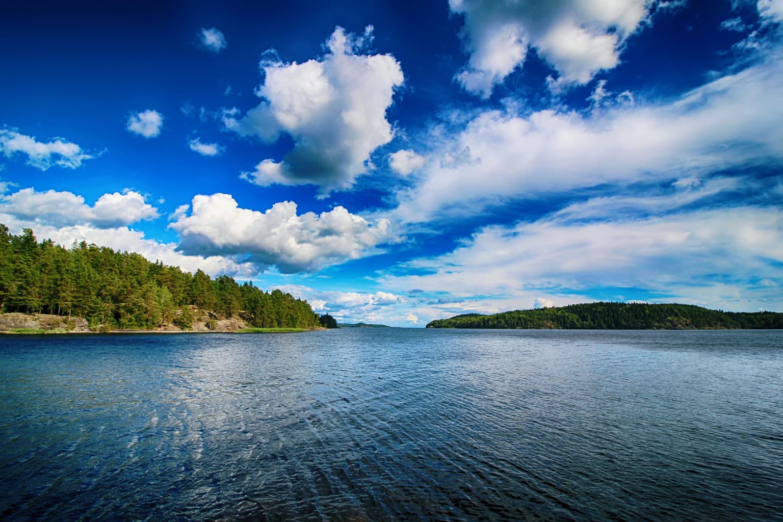
The park is best known for its extraordinary skerry landscape, a rare collection of rocky islands, narrow channels, and coastal formations that characterize the northwestern shore of Lake Ladoga. This archipelago environment is unlike any other protected area in Russia, combining dramatic island topography with boreal forest ecosystems. The park preserves one of the most ecologically significant island systems in European lacustrine environments, with particularly high plant biodiversity including 748 vascular plant species, over 350 bryophyte species, and more than 700 lichen species. The contrast between the forested island slopes and the open waters of Lake Ladoga creates a distinctive visual and ecological character that defines the park's identity.

Calm lake water with forested islands in the distance under a blue sky with scattered clouds
Lake Ladoga with forested islands and rocky skerries under a bright blue sky in August

Ladoga Skerries National Park history and protected-area timeline

The establishment of Ladoga Skerries National Park represents a decades-long conservation journey that began with early proposals in the late 1980s. The Karelian Research Centre of the Russian Academy of Sciences first suggested creating a national park in this area, recognizing the exceptional natural value of the Lake Ladoga archipelago. However, the proposal faced obstacles including the proximity of the town of Sortavala and the presence of numerous country houses in the area, which complicated land allocation and community relations. A second attempt came in 1999 when the European Union sponsored a conservation project with 3.5 million euros in funding, but this initiative also failed to achieve its goal. Project authors noted that the attitude of the local community toward the park remained one of the most challenging aspects of establishment. Despite these setbacks, conservation advocates persisted, and the park was finally created on December 28, 2017, when the Government of Russia issued an official order establishing the protected area. Recent controversy arose in 2024 when investigative reporting revealed that a four-square-kilometer portion of the park at Marjalahti Bay had been designated for exclusive use, though this development falls outside the park's core conservation mission.

Ladoga Skerries National Park landscape and geographic character

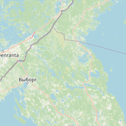
The physical landscape of Ladoga Skerries National Park is dominated by its archipelago setting on Lake Ladoga, creating one of Europe's most distinctive lake-based protected environments. Approximately 500 islands of varying sizes are distributed across the park's coastal zone, their rocky foundations shaped by glacial processes that also formed the basin of Lake Ladoga itself. The islands feature irregular coastlines with numerous inlets, bays, and channels that provide the skerry character the park is named for. The terrain on individual islands ranges from gentle slopes covered in forest to more dramatic rocky exposures, with elevation changes generally modest given the island setting. The surrounding waters of Lake Ladoga, covering 44 percent of the park area, include both the open lake environment and the more sheltered channels between islands. The combination of rocky island shores, forested slopes, and extensive water areas creates a mosaic landscape that is visually striking and ecologically complex.

Ladoga Skerries National Park ecosystems, habitats, and plant life

The ecological character of Ladoga Skerries National Park reflects its position within the southern Scandinavian and Russian taiga, a vast belt of coniferous forests that spans northern Europe and Russia. The park's vegetation is dominated by pine and spruce forests that cover the islands, creating the classic boreal forest appearance of the region. However, the island environment and lake setting introduce additional ecological complexity. Plant biodiversity within the park is notably high for a boreal area, with 748 vascular plant species recorded, of which 101 are protected under regional conservation listings. The park is particularly notable for its bryophyte and lichen diversity, with almost 350 species of mosses, liverworts, and hornworts documented, along with over 700 lichen species. This cryptogamic diversity reflects the moist island environment and the presence of diverse microhabitats ranging from forest floors to rocky outcrops. The aquatic component of the park supports ecosystem functions for Lake Ladoga's fish populations, with species including freshwater whitefish, bream, and northern pike known to inhabit the protected waters.

Ladoga Skerries National Park wildlife and species highlights

The wildlife of Ladoga Skerries National Park is characterized by the boreal forest communities typical of the taiga ecoregion, with species adapted to the mixed island and lake environment. The surrounding waters of Lake Ladoga support several fish species of ecological and conservation importance, including freshwater whitefish, bream, and northern pike. These species represent the lake's ecological community and benefit from the protection the park provides to their aquatic habitats. While the Wikipedia source provides limited detail on terrestrial wildlife, the forest-dwelling fauna would include species typical of the Scandinavian and Russian taiga, such as various small mammals, forest birds, and insects that occupy the coniferous and mixed forest habitats. The island setting creates distinct ecological conditions that support both forest-dwelling species and those associated with aquatic and shoreline environments.

Ladoga Skerries National Park conservation status and protection priorities

Ladoga Skerries National Park represents an important addition to Russia's protected area network, preserving a unique lacustrine archipelago environment that had long been recognized for its natural value. The park's establishment fulfills decades of conservation advocacy, beginning with scientific proposals in the 1980s and surviving multiple failed attempts at creation. The high plant biodiversity documented within the park, including numerous protected species and exceptional bryophyte and lichen communities, demonstrates the ecological significance of this island landscape. The park's classification as IUCN Category II reflects its status as a national park with primary protection goals focused on ecosystem conservation and recreation. By protecting the skerry archipelago of Lake Ladoga, the park preserves not only terrestrial forest ecosystems but also the aquatic environment and the transitional shoreline habitats that are essential to the region's ecological integrity.

Ladoga Skerries National Park cultural meaning and human context

The park exists within a region with complex historical and cultural dimensions. The nearby town of Sortavala was mentioned in the park's establishment history as a complicating factor due to its proximity and the presence of country houses in the area. This reflects the human landscape that intersects with the protected area, where local communities have historical connections to the Lake Ladoga shoreline. The post-World War I era saw Lake Ladoga become popular among tourists, establishing a tradition of recreation and appreciation for the lake's distinctive landscape that continues today. The region has also been subject to geopolitical changes over the past century, as the border between Russia and Finland has shifted, influencing settlement patterns and land use in Karelia.

Top sights and standout views in Ladoga Skerries National Park

The Ladoga Skerries archipelago stands as the park's defining feature, offering a rare example of a lake-dominated protected landscape in Europe. The approximately 500 islands with their rocky shores and forested slopes create a distinctive visual character that sets this park apart from other Russian protected areas. The exceptional plant biodiversity, with nearly 750 vascular plant species and outstanding bryophyte and lichen communities, demonstrates the ecological richness of this boreal island environment. The park's position on Lake Ladoga, Europe's largest lake, provides a setting of considerable geographic significance. The contrast between the conifer-covered islands and the open waters of the lake creates a landscape of considerable scenic value. The park also represents the culmination of decades of conservation effort, making its establishment a significant achievement in Russian environmental protection.

Best time to visit Ladoga Skerries National Park

The optimal time to experience Ladoga Skerries National Park aligns with the brief northern summer season when conditions are most favorable for outdoor exploration. Summer months bring warmer temperatures and longer daylight hours that allow visitors to appreciate the island landscapes and waters of Lake Ladoga. The boreal forest reaches its fullest expression during the growing season, when the pine and spruce forests display their characteristic green canopy across the islands. Autumn can offer another compelling window for visitation as the forest colors transition, though the season is short and quickly gives way to the long northern winter. Winter brings cold temperatures and snow cover that transform the islands into a very different landscape, though access becomes more challenging. The shoulder seasons of late spring and early autumn may offer favorable conditions for those seeking fewer visitors while still enjoying reasonable weather for exploration.

Park location guide

Geography guide, regional context, and park location map for Ladoga Skerries National Park

Ladoga Skerries National Park park geography, regions, and map view in Russia
Understand where Ladoga Skerries National Park sits in Russia through a broader geographic reading of the surrounding landscape, nearby location context, and its mapped position within the national park landscape.

How Ladoga Skerries National Park fits into Russia

Russia is a transcontinental nation spanning eleven time zones, bordered by fourteen countries. It is the world's largest country by area, covering 17,098,246 km². Moscow is the capital and largest city, while Saint Petersburg is the second-largest and a major cultural centre.

Wider geography shaping Ladoga Skerries National Park in Russia

Russia spans Eastern Europe and North Asia, covering 17,098,246 km². It shares land borders with fourteen countries, more than any other nation, and spans eleven time zones. The landscape includes vast plains, mountain ranges such as the Urals and Caucasus, and extensive coastlines along the Arctic Ocean, Pacific Ocean, Baltic Sea, Black Sea, and Caspian Sea.

Map view of Ladoga Skerries National Park

Use this park location map to pinpoint Ladoga Skerries National Park in Russia, understand its exact geographic position, and read its mapped placement within the surrounding landscape more clearly.

Pigeon | © OpenStreetMap contributors

Location context for Ladoga Skerries National Park

Republic of Karelia

Explore the rugged skerry terrain, forested island habitats, and pristine waters of this unique Russian protected area.

Ladoga Skerries National Park Photos: Visualizing Boreal Islands and Lake Ladoga Landscapes
Browse a visual atlas of Ladoga Skerries National Park to deeply understand its extraordinary skerry landscapes, boreal forest ecosystems, and unique island habitats across Lake Ladoga. The comprehensive imagery serves as a crucial resource for grasping the park's distinct geographic features, conservation character, and the visual identity of its rocky archipelago terrain.

Calm lake water with forested islands in the distance under a blue sky with scattered clouds

Park atlas

Explore national parks and protected areas, comparing diverse landscapes across northern Russia's unique boreal and lacustrine geography.

Discover Other Protected Areas Near Ladoga Skerries National Park: Explore Adjacent Landscapes
After exploring Ladoga Skerries National Park, browse other nearby protected areas and national parks, tracing the unique patterns of conservation across northern Russia's boreal forests and extensive lake systems. This geographic view helps compare diverse island-dominated landscapes, skerry formations, and other significant protected environments, providing deeper context for regional park discovery.
National parkNorth Karelia

Petkeljärvi National Park: Distinct Protected Landscape and Esker Formations in North Karelia

Discover Finland's unique esker ridges and boreal forests.

Petkeljärvi National Park represents a distinctive protected landscape in North Karelia, Finland, celebrated for its prominent esker formations that define its topography. The park showcases light Scots pine forests growing on sandy soils, creating an open forest character that sets it apart. Visitors can explore the mapped geography, including winding ridges, wetlands, and lake scenery, alongside preserved historical fortifications from the Continuation War, offering a rich blend of natural and cultural heritage within this compact national park.

Area
7 km²
Established
1956
IUCN
II
Visitors
17.3K annual
National parkEtelä-Savo

Kolovesi National Park: Mapped Protected Landscape in Etelä-Savo, Finland

Explore its geographic identity and mapped park boundaries.

Kolovesi National Park is a significant protected area located in the Etelä-Savo region of Finland, characterized by its presence within the Finnish lake district. This detailed page provides an atlas-centric view, emphasizing the park's mapped geographic features and its status as a protected natural landscape. Users engaging with MoriAtlas can understand Kolovesi National Park's unique landscape context and its precise location within the regional geography of southeastern Finland.

Area
61 km²
Established
1990
IUCN
II
Visitors
17.2K annual
Watercolor illustration showing a lake with islands and forested shores, distant hills, and soft pastel colors
National parkSouth Savo

Linnansaari National Park: South Savo's Protected Landscape and Geography

Explore the mapped boundaries of this Finnish national park.

Discover Linnansaari National Park, a distinct national park located in South Savo, Finland. This page provides detailed information focused on its protected landscape identity, mapped geography, and atlas context. Understand its significance as a conservation area and how its boundaries contribute to the regional natural landscape. Explore the geographic positioning of Linnansaari National Park within South Savo, offering insights for structured map-based discovery.

Area
38 km²
Established
1956
IUCN
II
Visitors
31.6K annual
National parkNorth Karelia

Patvinsuo National Park: Protected Landscape Geography and Map Context

National park exploration in North Karelia, Finland.

Patvinsuo National Park stands as a vital protected area within North Karelia, Finland. This page serves as an atlas entry point, detailing the park's geographic scope, mapped boundaries, and its significance as a protected landscape. Users can explore the regional context and understand the natural terrain that characterizes this important Finnish national park, facilitating structured geographic discovery.

Area
105 km²
Established
1982
IUCN
II
Visitors
18.6K annual
Watercolor illustration of a landscape featuring green vegetation, rolling hills, and a body of water under a pastel sky
National parkNorth Karelia

Koli National Park: Protected National Park in North Karelia, Finland

Explore mapped landscape and regional geography.

Koli National Park represents a significant protected area within the eastern Finnish region of North Karelia. This page offers detailed geographic context and insight into the park's mapped landscape, essential for understanding its place within the broader atlas of Finland's natural terrain. Discover the protected boundaries and regional setting of this key national park.

Area
30 km²
Established
1991
IUCN
II
Visitors
249.8K annual
Natural monumentRepublic of Karelia

Mount Vottovaara Natural Monument: Explore Protected Landscape and Geographic Context in Karelia

Mapped protected area boundaries and regional terrain in the Republic of Karelia.

Mount Vottovaara represents a significant natural monument within the Republic of Karelia, offering a focal point for structured geographic exploration. This protected landscape's mapped boundaries and its setting within the region's broader geography are key to understanding its atlas value. MoriAtlas provides the framework to examine the specific identity of Mount Vottovaara as a protected area, encouraging detailed study of its natural features and regional context.

Area
15 km²
Established
2011
Relief
Mixed relief
Climate
Boreal
Watercolor illustration showing a landscape with mountains, a winding river, and patches of green vegetation and trees
National parkFinland

Repovesi National Park: Finland's Boreal Wilderness and Protected Landscape

Explore mapped terrain and regional geography.

Repovesi National Park represents a significant protected natural area in southeastern Finland, showcasing a landscape characterized by dense boreal forests, rolling hills, and numerous lakes. As one of Finland's most visited national parks, it offers a compelling example of conserved wilderness and natural terrain. This page details the park's protected landscape identity, its geographic setting within Finland, and the atlas-driven insights available for exploring its mapped boundaries and natural features.

Area
15 km²
Established
2003
IUCN
II
Visitors
100.9K annual
National parkKymenlaakso

Eastern Gulf of Finland National Park: Kymenlaakso's National Park and Coastal Geography

Explore protected lands and mapped terrain.

The Eastern Gulf of Finland National Park is a designated national park located in the Kymenlaakso region of southeastern Finland. This entry provides specific geographic context for the park, detailing its role as a protected landscape and its mapped boundaries within the coastal atlas of the Gulf of Finland. Understanding its regional setting within Kymenlaakso allows for a more structured exploration of Finland's protected natural areas and their unique geographic identities.

Area
6 km²
Established
1982
IUCN
II
Visitors
15.8K annual

Common questions about visiting, size, designation, and location context for Ladoga Skerries National Park

Ladoga Skerries National Park FAQs for park facts, access, geography, and protected area context
Find quick answers about Ladoga Skerries National Park, including protected-area facts, park geography, trail and visitor context, and how the park fits into its surrounding country and regional landscape.
MoriAtlas Explorer

Continue Your Protected Areas Search Across the Global Atlas

Deepen your exploration by continuing the structured search for national parks and protected areas worldwide. Utilize the comprehensive filtering capabilities to compare different conservation landscapes and refine your understanding of global park geography. Discover more about the distribution and characteristics of protected natural areas.

Global natural geography