
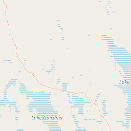
Lakes
Park geography
A technical overview of mapped park areas, landscape features, and environmental zones
Lake Gairdner National Park Geographic Profile: Boundaries, Terrain, and Regional Context
This geographic profile details the physical scope of Lake Gairdner National Park within South Australia. It includes structured data on regional boundary measurements, the spatial distribution of lacustrine and desert habitats, and the specific positions of internal natural landmarks like Waltumba Hill and Lake Gairdner.
Related tags
Salt LakesArid LandscapesWetland EcosystemsBirdwatchingOutback Wilderness
Arid South Australian salt lake wilderness with seasonal wetland ecosystems
Lake Gairdner National Park
Lake Gairdner National Park is a vast protected area in the arid interior of South Australia, located approximately 436 kilometers northwest of Adelaide. The park encompasses a chain of three ephemeral salt lakes—Lake Gairdner, Lake Harris, and Lake Everard—that form a distinctive landscape of white salt-crusted basins surrounded by red earth and sparse arid vegetation. This region experiences extremely hot summer temperatures and receives minimal rainfall, creating one of Australia's most challenging yet ecologically fascinating desert environments. The park's ecological character transforms dramatically with seasonal rainfall. When sufficient precipitation occurs, these salt lakes fill with water, creating shallow ephemeral wetlands that attract thousands of migratory birds and provide critical habitat for waterfowl. During these brief periods of abundance, the otherwise barren landscape becomes alive with birdlife, making the park particularly significant for birdwatchers and botanists who visit during the spring months. The surrounding arid country supports specialized desert flora adapted to extreme aridity and high salinity soils. Lake Gairdner National Park holds International Union for Conservation of Nature Category VI status, reflecting its designation as a protected area with sustainable use of natural resources. The park is situated just south of the Trans-Australian Railway and Stuart Highway, though public access remains limited due to its remote location and surrounding pastoral leases. The region holds deep cultural significance as the traditional country of the Kokatha people, whose ancestral connections to this landscape continue through ceremonial site visits and heritage values.
- Location
- Australia
- Park type
- National park
- Established
- 1991
- Area
- 5,531.8 km²
Location overview
Territorial boundaries and regional placement in South Australia
Geographic Location of Lake Gairdner National Park in Australia
Lake Gairdner National Park is located in South Australia under the national jurisdiction of Australia. Official records verify that the inland protected area holds no coastal, marine, or transboundary designations.
- Countries
- Australia
- Regions
- South Australia
- Primary location
- South Australia
- Geographic setting
- Inland
Boundary and coordinates
Interactive boundary geometry and calculated area metrics
Lake Gairdner National Park Boundary Map and Spatial Extent
Mapped park outlines provide precise spatial context for exploring protected geographic limits and regional layouts. Accompanying measurements detail total surface area, coordinate boundaries, and geographic span figures.
- Boundary area
- 5,569.3 km²
- Boundary perimeter
- 1,424.2 km
- Northernmost point
- 30.9983° S
- Southernmost point
- 32.369° S
- Easternmost point
- 136.3231° E
- Westernmost point
- 134.7085° E
- Geographic centre
- 31.5947° S, 135.772° E
- North–south span
- 152 km
- East–west span
- 153.1 km
Terrain and natural features
Lowland terrain classification and recorded natural features within protected boundaries
Lake Gairdner National Park Terrain and Natural Features
Protected lowland terrain classifications categorize the landscape alongside recorded natural features located within the park boundaries. Linked feature cards supply names, types, measurements, and spatial relationships where available in the dataset.
Selected named natural features
Peaks
Waltumba Hill
189 m
Environmental setting
Arid lowland terrain, lacustrine basins, and desert habitat categories
Lake Gairdner National Park Environmental Setting and Landscape Classifications
Recorded classifications group desert and lacustrine habitats alongside arid climate parameters to frame the physical setting. Connected atlas categories link individual environmental traits to related protected areas.
- Relief
- Lowland
- Climate
- Arid
- Water
- Minor water
- Forest cover
- No forest cover
- Seasonality
- Strongly seasonal
Landscape features
Lakes · Desert
Habitat types
Lacustrine habitat · Desert habitat
Park atlas
Trace the arid interior's mapped geography, comparing surrounding salt lake systems and diverse conservation landscapes across South Australia.
Discover Other National Parks and Protected Areas Near Lake Gairdner National Park, South Australia
Continue your exploration beyond Lake Gairdner National Park by browsing other protected areas, including additional salt lakes and arid landscapes within South Australia's vast interior. Compare geographic features, ecological profiles, and conservation statuses to gain a broader understanding of the region's unique protected landscapes and their interconnectedness.
National parkSouth Australia
29 km away#1 closest
South

Gawler Ranges National Park: South Australia's Mapped Protected National Landscape
Explore the geography and protected area context of this national park.
Gawler Ranges National Park stands as a significant protected area within the geographic expanse of South Australia. Designated as a national park, it offers valuable insights into Australia's conservation landscapes and regional geography. Users can explore its mapped boundaries and understand its unique role within the national park system, making it a key point for structured geographic study and atlas-based discovery of protected lands.
- Area
- 1,628.75 km²
- Established
- 2002
- IUCN
- VI
- Relief
- Mountain
Nature reserveSouth Australia
About 55 km away#2 closest
North
Bon Bon Reserve: Geographic Profile of a South Australian Nature Reserve
Arid outback landscapes and protected habitat connectivity
Spanning over 2,164 square kilometres, Bon Bon Reserve is a significant nature reserve in the arid South Australian interior. This mapped landscape features a diverse mosaic of mulga woodlands, bluebush plains, and ephemeral salt lake systems that provide a vital refuge for threatened species and secure ecological connectivity across the outback.
- Area
- 2,164.53 km²
- Established
- 2008
- IUCN
- II
- Relief
- Lowland
State or regional parkSouth Australia
About 71 km away#3 closest
South
Corrobinnie Hill Conservation Park: Mapped Protected Landscapes and Geological Features
A remote conservation site on the Eyre Peninsula
Corrobinnie Hill Conservation Park protects an exceptional granite outcrop that stands as a natural monument within the South Australian landscape. The site is characterized by its weathered rock formations and its geographic connection to the broader Pinkawillinie conservation estate, offering insight into the geological diversity of remote Eyre Peninsula pastoral country.
- Area
- 2.08 km²
- Established
- 1983
- IUCN
- III
- Relief
- Upland
Wildlife reserveSouth Australia
73 km away#4 closest
Southwest
Gawler Ranges Conservation Park: Mallee Landscapes and Regional Protected Areas
Semi-arid habitat and rocky terrain of South Australia
Gawler Ranges Conservation Park protects a core area of tree mallee woodland and rocky rises near the southern fringe of the Gawler Ranges. This wildlife reserve serves as an essential anchor for regional biodiversity on the Eyre Peninsula, offering a look at the arid-adapted vegetation and weathered geological structures that define this remote section of South Australia.
- Area
- 154.8 km²
- Established
- 1993
- IUCN
- VI
- Relief
- Upland
Nature reserveSouth Australia
97 km away#5 closest
South
Caralue Bluff Conservation Park: A Protected Nature Reserve on the Eyre Peninsula
Mapping regional landscape integrity in South Australia
Caralue Bluff Conservation Park encompasses a 21.5 square kilometre tract of land in South Australia, acting as a crucial element of the Eyre Peninsula landscape. Named for the nearby Caralue Bluff landform, this nature reserve safeguards essential bushland habitats within a highly developed rural setting. Analyze the park boundaries and terrain characteristics to better appreciate its function as a conserved natural refuge.
- Area
- 21.57 km²
- Established
- 1993
- IUCN
- VI
- Scope
- Terrestrial
National parkSouth Australia
113 km away#6 closest
East
Lake Torrens National Park: Explore South Australia's Remarkable Inland Salt Lake Geography
A unique protected landscape of arid plains and expansive salt flats.
Lake Torrens National Park offers an unparalleled exploration of Australia's remote outback, centered around a vast, ancient salt lake basin. This national park in South Australia provides a canvas of stark, minimalist terrain, featuring shimmering saltpans, arid gibber plains, and rocky outcrops. Understand the park's unique geographic identity, its ecological significance as a temporary wetland habitat, and its dramatic visual appeal for landscape photography and geological interest. It is a key protected area showcasing the extreme environment of Australia's interior.
- Area
- 5,676.68 km²
- Established
- 1991
- IUCN
- VI
- Relief
- Lowland
Wildlife reserveSouth Australia
119 km away#7 closest
South
Darke Range Conservation Park: A Protected Woodland Sanctuary in South Australia
Geographic landscape and regional habitat exploration
Located near Darke Peak, this wildlife reserve safeguards threatened native peppermint gum woodland. The park functions as an ecologically significant pocket of intact vegetation, providing a window into the natural ridge terrain of the Eyre Peninsula that remains distinct from the surrounding rural land.
- Area
- 6.93 km²
- Established
- 1985
- IUCN
- VI
- Relief
- Mountain
Nature reserveSouth Australia
About 120 km away#8 closest
South
Carappee Hill Conservation Park: Atlas and Geographic Protected Area Profile
Nature reserve geography and Eyre Peninsula landscape context
Carappee Hill Conservation Park covers 8.5 square kilometres of rocky, elevated terrain in the locality of Darke Peak. As a designated conservation area and IUCN Category III site, it serves as a critical refuge for native vegetation, providing a clear map of protected landform heritage in central South Australia.
- Area
- 8.5 km²
- Established
- 1973
- IUCN
- III
- Relief
- Upland
MoriAtlas Explorer
Continue Exploring Lake Gairdner National Park's Geographic and Protected Landscape Context
Deepen your understanding of Lake Gairdner National Park by exploring its precise geographic features and its status as a protected national park within South Australia. This allows for detailed analysis of its landscape, mapped territory, and regional significance, providing a richer atlas perspective for those interested in conservation landscapes and their geographic representation. Further investigation into its protected natural area characteristics enhances your comprehension of Australia's diverse park geography.
Browse next
Global natural geography
Explore related park routes
Explore MoriAtlas Global ParksBrowse All MoriAtlas ParksGlobal Park Map DiscoveryMoriAtlas: Browse All CountriesBrowse All MoriAtlas ContinentsNational Park Environment AtlasGrand Canyon National Park AtlasYellowstone National Park AtlasYosemite National Park Atlas and GeographySerengeti National Park AtlasGalápagos National Park Protected LandscapeBanff National Park Geography and AtlasKruger National Park Atlas EntryUluṟu-Kata Tjuṯa National Park AtlasExplore Uluru-Kata Tjuta National Park GeographyPlitvice Lakes National Park AtlasFiordland National Park Protected LandscapeGreat Smoky Mountains National Park AtlasAfghanistan National Parks and Protected AreasAlbania National Parks and Protected AreasAlgeria National Parks and Protected AreasAmerican Samoa National Parks and Protected AreasAndorra National Parks and Protected AreasAngola National Parks and Protected AreasAntarctica National Parks and Protected AreasAntigua and Barbuda Park List