
Mori Atlas logo
Protected areaLake Kerkini

A mapped overview of the reservoir and its surrounding mountain-backed landscape

Lake Kerkini Protected Area and Wetland Geography in Central Macedonia, Greece

(Kerkini National Park (Ethniko Parko Kerkinis))

Lake Kerkini stands as a significant artificial reservoir in Central Macedonia, Greece, established along the Strymon River to anchor a complex wetland ecosystem. This protected area connects diverse natural features, including riparian forests, reed beds, and water-lily colonies, all framed by the contrasting peaks of the Belasica and Krousia mountains. Serving as a critical stopover on major migratory flyways, the basin offers a unique look at how managed hydraulic infrastructure and rich wildlife habitats coexist within a Mediterranean regional landscape.

wetlandartificial reservoirbirdwatchingmigratory birdsramsar sitenational park
A flat vector-style illustration of a wetland landscape with a winding river, cattails in the foreground, water lilies, and a bank of mist hovering before distant mountain ranges.

Lake Kerkini

Protected area

Park overview

Structured park overview, official facts, and landscape profile for Lake Kerkini

Lake Kerkini park facts, protected area profile, and essential visitor context

Review the core facts for Lake Kerkini, including designation, size, terrain, visitor scale, habitats, and operating context in one park-focused overview.

About Lake Kerkini

Lake Kerkini is one of the defining natural landmarks of Central Macedonia, anchoring both the ecological identity and the rural economy of the Serres region. Although it is an artificial reservoir, its origins lie in a landscape that was already remarkable: before 1932, irregular marsh lakes filled the Strymon floodplain, one of which, known historically as Podkova, gave the area an Ottoman-era identity.

Following the construction of embankments and a dam near the village of Lithotopos in 1932, the lake took shape as a managed hydraulic system supporting irrigation across the plains. By 1980, silt accumulation had reduced its capacity, prompting the raising of embankments and a new dam that came into operation in 1982. Today, the lake is maintained as both a working agricultural asset and a protected natural area, a balance that has become central to its identity.

Lake Kerkini's broader setting, between the Belasica and Krousia ranges and the agricultural plains below, makes it a transitional landscape where mountains, freshwater wetlands, and farmland meet. Its protected status covers not just the open water but also stretches of the Strymon River and surrounding forests and mountains, all of which contribute to its ecological richness. The lake functions as a living laboratory for wetland management and as a refuge for species that depend on intact freshwater habitats in an otherwise heavily cultivated region.

Quick facts and research context for Lake Kerkini

Lake Kerkini lies in the Serres regional unit of Central Macedonia, in northern Greece, near the villages of Lithotopos and Kerkini. It is an artificial reservoir on the Strymon River, with the Kerkinitis and Krousia rivers contributing additional water. Its surface area fluctuates between roughly 54 and 72 square kilometers, depending on water management and season.

The lake was designated as a Ramsar Wetland of international importance in 1975 under the official name 'Artificial Lake Kerkini' and is also part of the European Natura 2000 network. The core of the surrounding Kerkini National Park includes the lake itself and the Strymon River corridor up to the Greek-Bulgarian border, while a wider peripheral zone extends into the Belasica (Belles), Krousia, and Mavrovouni mountain ranges.

Protection and recognition

Documented designation timeline, management scope, and international recognition data

Lake Kerkini Protection Status and Terrestrial Conservation History

Lake Kerkini preserves an established terrestrial protected area designation originating from 1975 without transboundary classifications. Documented conservation records outline management scope and historical protection frameworks for ongoing geographic analysis.

Protection details

Protection scope
Terrestrial
Designated year
1975
Transboundary protection
No
Park context

Deeper park guide and search-rich context for Lake Kerkini

Lake Kerkini history, landscape, wildlife, and travel context

Explore Lake Kerkini through its history, landscape character, ecosystems, wildlife, conservation priorities, cultural context, and seasonal travel timing in a structured park guide built for atlas discovery and search intent.

Why Lake Kerkini stands out

Lake Kerkini is best known as one of Greece's most important wetlands for birdwatching, hosting large numbers of waterbirds, including globally important populations of Dalmatian pelicans, cormorants, herons, and ferruginous ducks. The lake sits along a major migratory route, drawing species moving between the Aegean, the Balkans, and northern Europe. Beyond its ornithological importance, Lake Kerkini is also recognized for its remarkable riverside forests, extensive water-lily beds, healthy fish populations, and the unusual presence of a large free-roaming herd of water buffalo in and around the shallows. The combination of dramatic mountain backdrop, varied wetland habitats, and visible coexistence of wildlife and traditional land use gives the lake a distinct character among Greek protected areas.
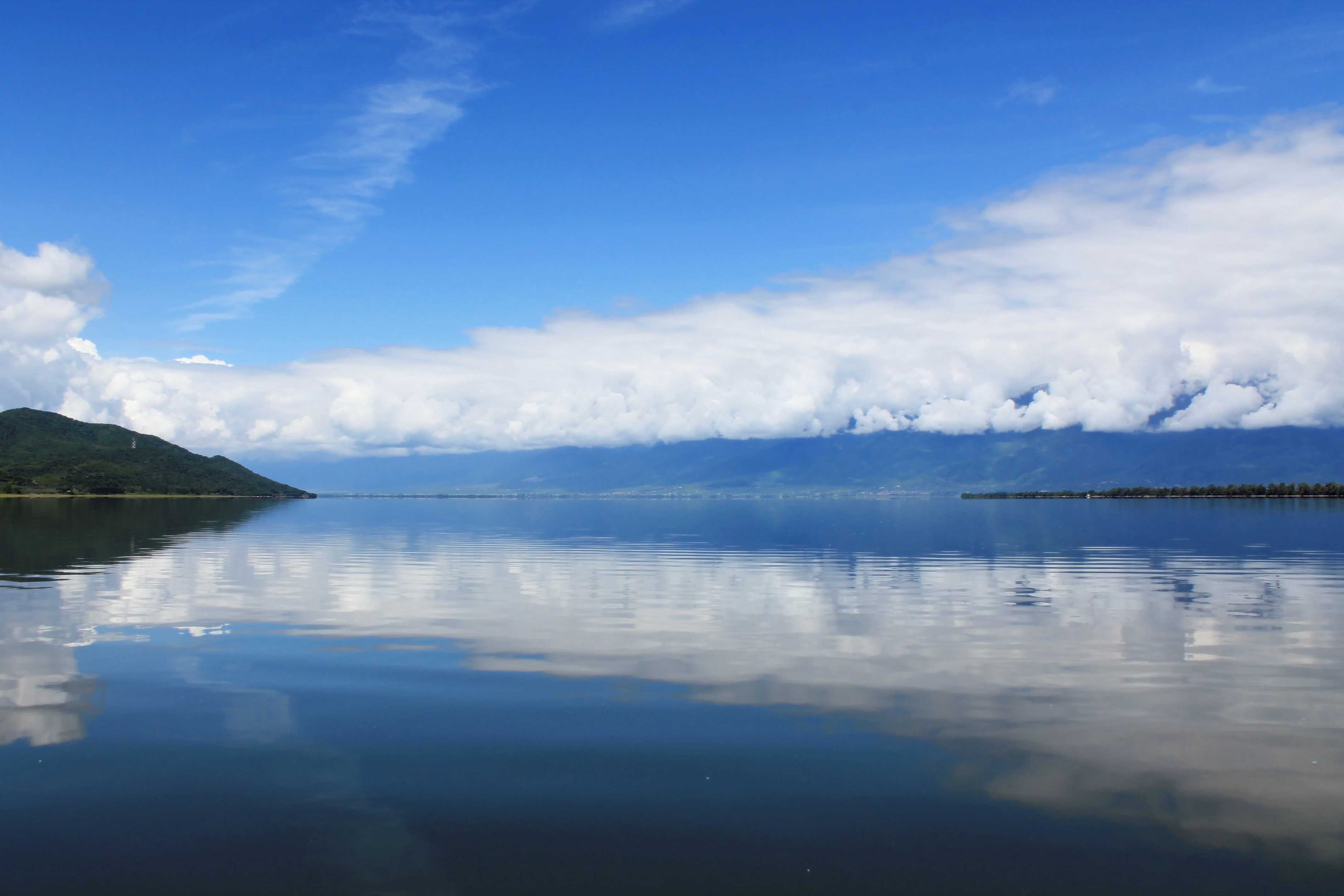
A wide landscape view of a calm lake reflecting a blue sky with large white clouds, with a green hill on the left and a line of trees on the distant horizon.
A calm view of Lake Kerkini reflecting the blue sky and white clouds.

Lake Kerkini history and protected-area timeline

Before any modern intervention, the area that is now Lake Kerkini consisted of irregular natural marsh lakes along the Strymon River. One of these was historically known as Podkova, a name recorded in Bulgarian, Slavic Macedonian, and Ottoman Turkish sources (as Podkova Gölü), and meaning 'Horseshoe' in reference to the lake's shape.

In 1932, embankments were built along the eastern and western sides of the Strymon, and a dam was constructed near the village of Lithotopos, transforming the marshes into a managed reservoir. The new lake was conceived primarily as an agricultural asset, providing irrigation water for the surrounding plains. Over time, however, sediment carried by the Strymon reduced the lake's storage capacity and gradually altered its shoreline.

By the late twentieth century, this silting had become significant enough to require a major upgrade. Embankments were heightened and a new, larger dam was built, with the revised system becoming fully operational in 1982. The result was a larger, more controllable reservoir that retained and expanded the wetland values of the original landscape. Lake Kerkini was formally recognized internationally when it was designated a Ramsar Wetland on 21 August 1975, and later incorporated into the European Natura 2000 network, cementing its dual role as both infrastructure and protected habitat.

Lake Kerkini landscape and geographic character

Lake Kerkini sits in a lowland basin framed by contrasting mountain ranges. To the north rise the slopes of Belasica (Belles) along the Greek-Bulgarian border, while to the west the Krousia mountains overlook the water. Between these ranges, the terrain opens into flat and semi-mountainous country, with cultivated lowlands extending to the south and east. The lake's own shoreline is a complex interplay of open water, reed margins, silty shallows, and vegetated banks.

The reservoir's form is elongated: at its maximum extent it stretches roughly 17 kilometers in length and about 5 kilometers in width, but its actual area is not static. Water levels fluctuate with seasonal management and the Strymon's flow, ranging roughly between 54 and 72 square kilometers. These fluctuations naturally create exposed mudflats, wet meadows, and shallow fringes, which are an important part of the lake's visual and ecological character.

The visual drama of Kerkini lies in the way the water mirrors the surrounding peaks, while patches of water-lily beds, riparian woodland, and grazing buffalo add texture to the scene. This blend of mountain backdrop, expansive water surface, and richly vegetated shoreline gives the landscape a layered and distinctly Macedonian character that differs from the more austere wetland landscapes elsewhere in Greece.
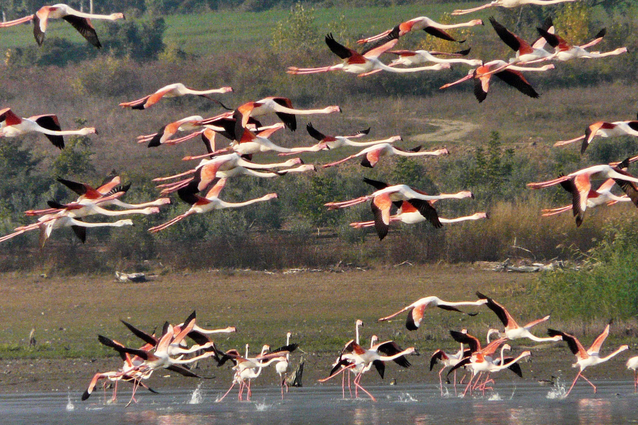
A flock of pink and white flamingos with black wingtips flying low over a body of water, with some birds taking off or landing near the shore.
A large flock of flamingos flying low over the water at Lake Kerkini.

Lake Kerkini ecosystems, habitats, and plant life

The natural environment of Lake Kerkini is defined by a richly varied wetland ecosystem, dominated by open freshwater, reed beds, riparian forests, and floating vegetation. Extensive beds of water-lilies contribute to the lake's seasonal character, while stretches of riverside forest along the Strymon and the lake's edges provide cover and nesting habitat for a wide range of species.

The lake sits at the intersection of several biogeographic influences. It lies along a major flyway for birds moving between the Aegean coast, the Balkans, the Black Sea region, and the open landscapes of Central and Eastern Europe, meaning that its species mix shifts considerably across the year, with breeding, passage, and wintering communities overlapping. Aquatic habitats support healthy populations of fish, amphibians, and reptiles, while the surrounding transitional zones of marsh, scrub, woodland, and pasture create a gradient of conditions that supports a wide variety of wildlife.

Because the lake is artificial but ecologically rich, it is often cited as an example of how man-made infrastructure, when carefully designed and managed, can mimic and even enhance the values of natural wetlands. The combination of fluctuating water levels, sheltered bays, and diverse shoreline vegetation patterns creates an unusually wide range of microhabitats within a relatively compact area.
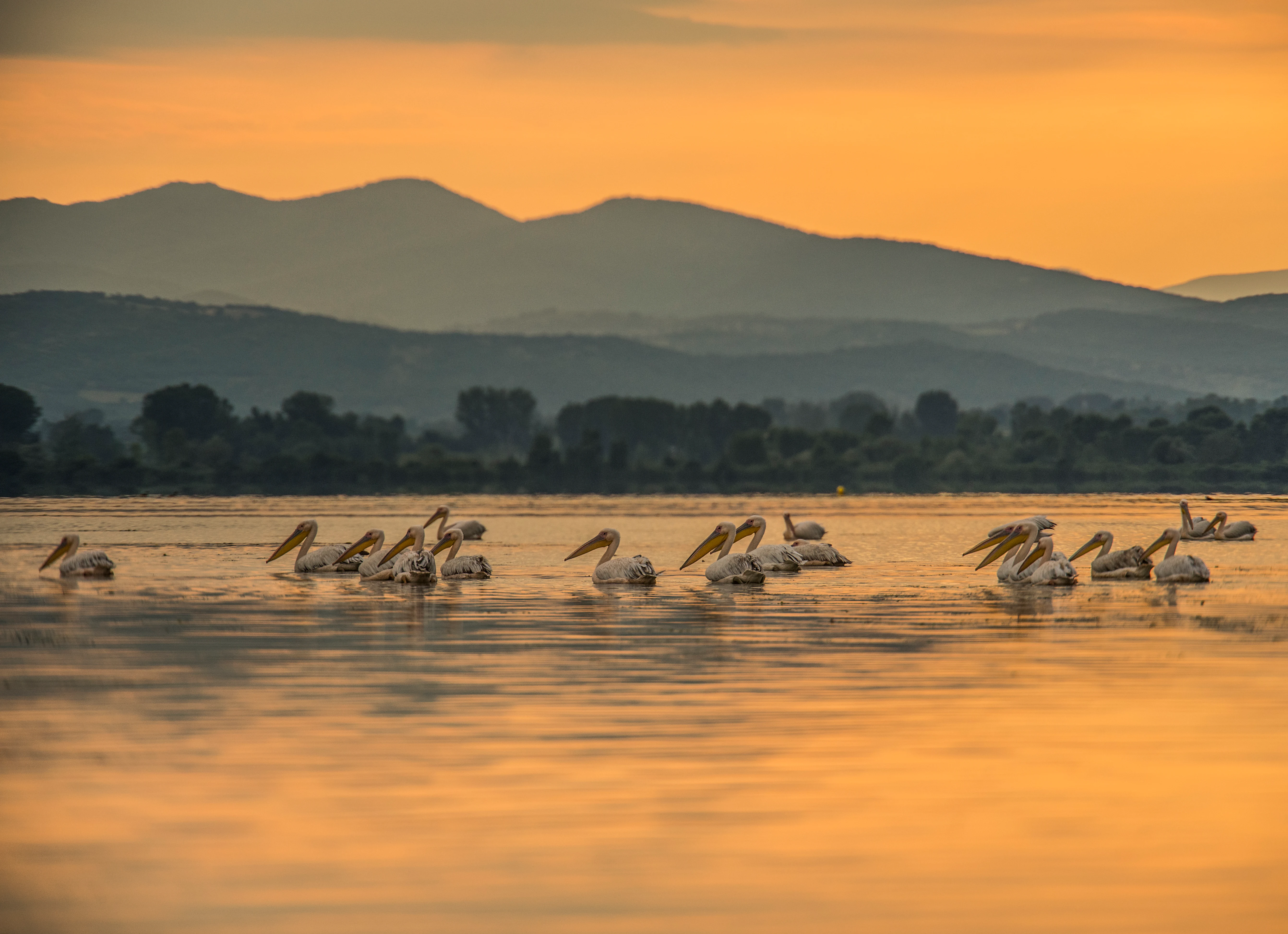
A flock of pelicans floating on a lake with mountains in the background under an orange sunset sky.
A flock of pelicans rests on the calm waters of Lake Kerkini during a golden sunset, with mountains silhouetted in the distance.

Lake Kerkini wildlife and species highlights

Lake Kerkini is exceptionally rich in birdlife, with the lake recognized as one of the leading birdwatching sites in Greece. The waterbody supports dense mixed colonies of herons, egrets, cormorants, and pelicans, while reed beds and shallows attract ducks, coots, and a wide range of passage migrants. The lake is particularly important for globally threatened species, including the Dalmatian pelican, which breeds in significant numbers here, and the ferruginous duck, which winters on the lake in internationally important concentrations.

Beyond birds, the lake is famous for its free-roaming herd of water buffalo, one of the largest of its kind in Greece. The buffalo wade through the shallows and graze along the shoreline, becoming part of the lake's distinctive atmosphere and contributing to the traditional rural character of the area. Their presence is unusual in a European protected area and gives Kerkini a cultural as well as an ecological identity.

The wider fauna of the surrounding mountains and lowlands is also significant. Mammals recorded in the area include jackals, wolves, wildcats, otters, roe deer, wild boar, and hares. Reptiles and amphibians are well represented, with around ten amphibian species and roughly twenty reptile species documented, along with a rich insect fauna that underpins the food chain. The fish community, supporting local fisheries and a broader ecological role, includes eels and other freshwater species characteristic of Strymon basin waters.
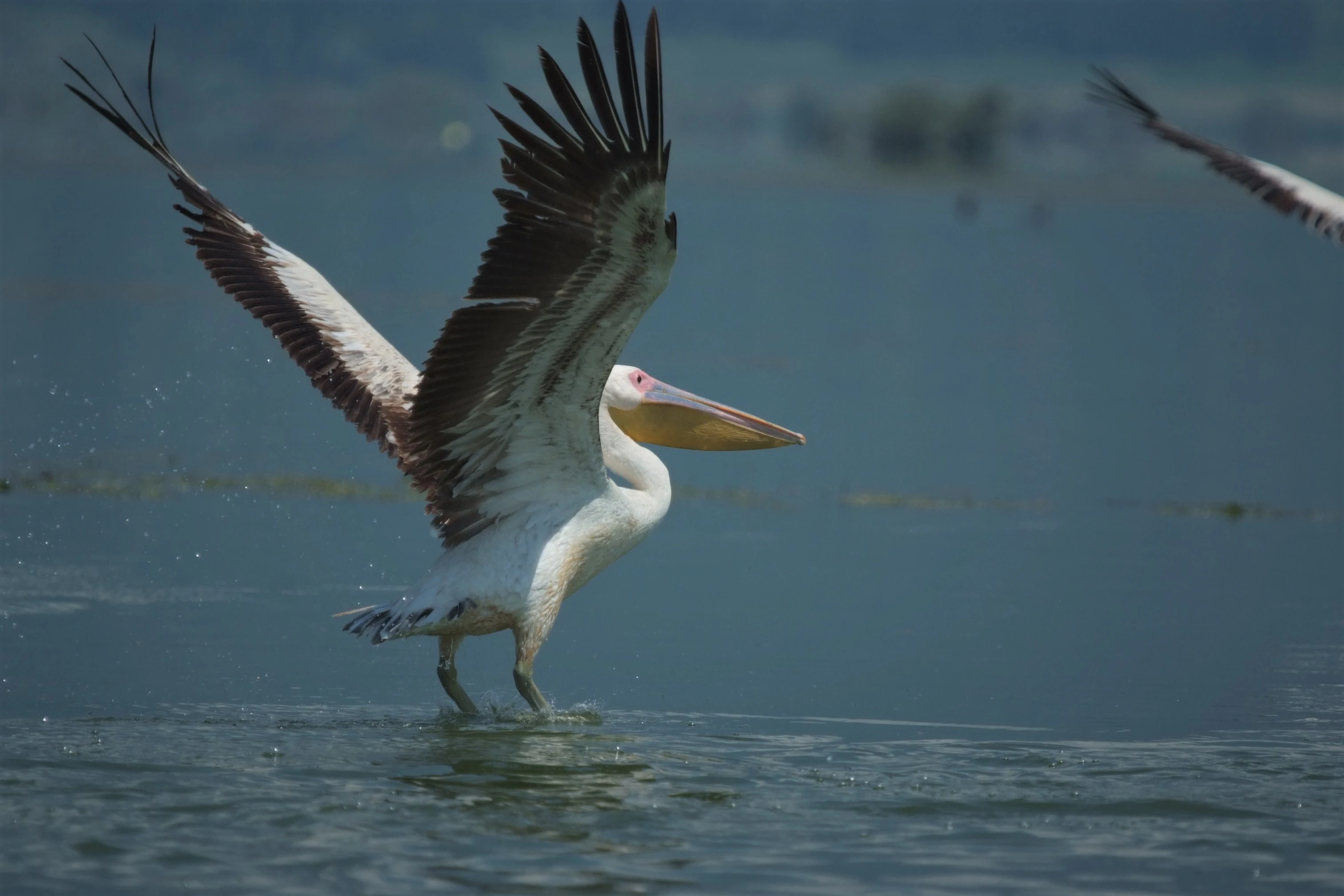
A Dalmatian pelican with white and black wings extended, touching down on the water surface.
A Dalmatian pelican landing on the water with wings fully spread.

Lake Kerkini conservation status and protection priorities

Lake Kerkini holds a strong conservation profile, anchored by its status as a Ramsar Wetland of international importance, designated in 1975 under the official name 'Artificial Lake Kerkini'. It is also part of the European Natura 2000 network, which adds a further layer of habitat and species protection under European Union nature law.

Within the broader Kerkini National Park framework, the lake and the adjacent stretch of the Strymon River to the Greek-Bulgarian border form a core protection zone, with stricter controls on human activity in sensitive areas. A wider peripheral zone extends into the surrounding mountains, including the Belasica (Belles), Krousia, and Mavrovouni ranges, linking the wetland ecosystem to forest and mountain habitats. This layered approach helps safeguard breeding colonies, roosting sites, and migration stopover points that depend on the absence of disturbance.

Conservation attention also extends to the threats facing the lake. Pollution of the Strymon, sedimentation, illegal logging, illegal fishing and hunting, and inappropriate visitor pressure on bird colonies all pose ongoing challenges. Embankment management can also influence the diversity of fish species. Despite these pressures, Lake Kerkini is widely regarded as a successful example of how a working reservoir can be managed in a way that maintains, and in some ways enhances, its value for biodiversity.

Lake Kerkini cultural meaning and human context

The lands around Lake Kerkini have long been embedded in the agricultural life of Central Macedonia. The lake itself was conceived as the central feature of an irrigation system for the surrounding plains, and its waters continue to shape village life, fisheries, and farming traditions in the Serres region. Traditional fishing boats remain a familiar sight on the water, and the lakeside villages of Lithotopos and Kerkini share their name with the lake and remain gateways to the area.

The region's layered cultural history is reflected in the lake's older name. Before the modern reservoir, the natural marshes were known in Bulgarian, Slavic Macedonian, and Ottoman Turkish as Podkova, a word meaning 'Horseshoe', a reminder that this landscape has been described and integrated into local life across multiple linguistic traditions. Today, the lake's iconography also includes the free-roaming buffalo herds, which tie modern conservation framing to long-standing pastoral practices in northern Greece.
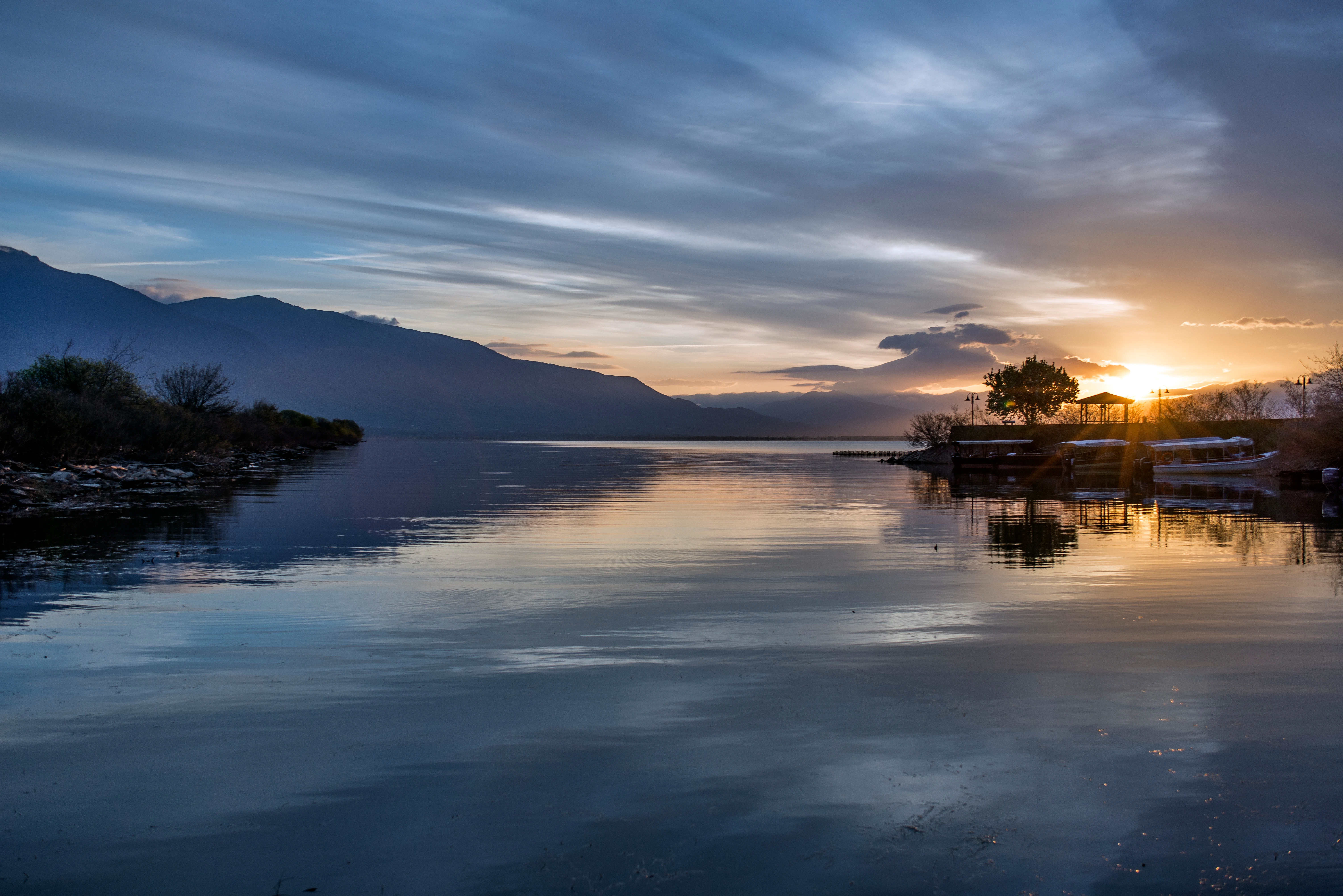
A wide landscape shot of a lake at sunset, featuring calm water reflecting the sky, mountains in the distance on the left, and a small port with trees and boats silhouetted against the sun on the right.
Sunset view over the calm waters of Lake Kerkini with mountains in the background and a small port on the right.

Top sights and standout views in Lake Kerkini

Lake Kerkini stands out for the unusual combination of an artificial reservoir functioning as one of Greece's richest freshwater habitats. Its waters support internationally important colonies of pelicans, herons, and ducks, while its forested margins, water-lily beds, and fish populations add further ecological depth. The surrounding backdrop of the Belasica and Krousia mountains gives the lake a striking scenic presence.

Equally distinctive is the lake's relationship with local people: the working landscape of embankments, irrigation, fisheries, and traditional pastoralism, including the well-known buffalo herds, remains visible alongside the protected wildlife. This visible coexistence of working land use and rich biodiversity gives Kerkini a depth and character that purely 'wild' wetlands tend to lack.
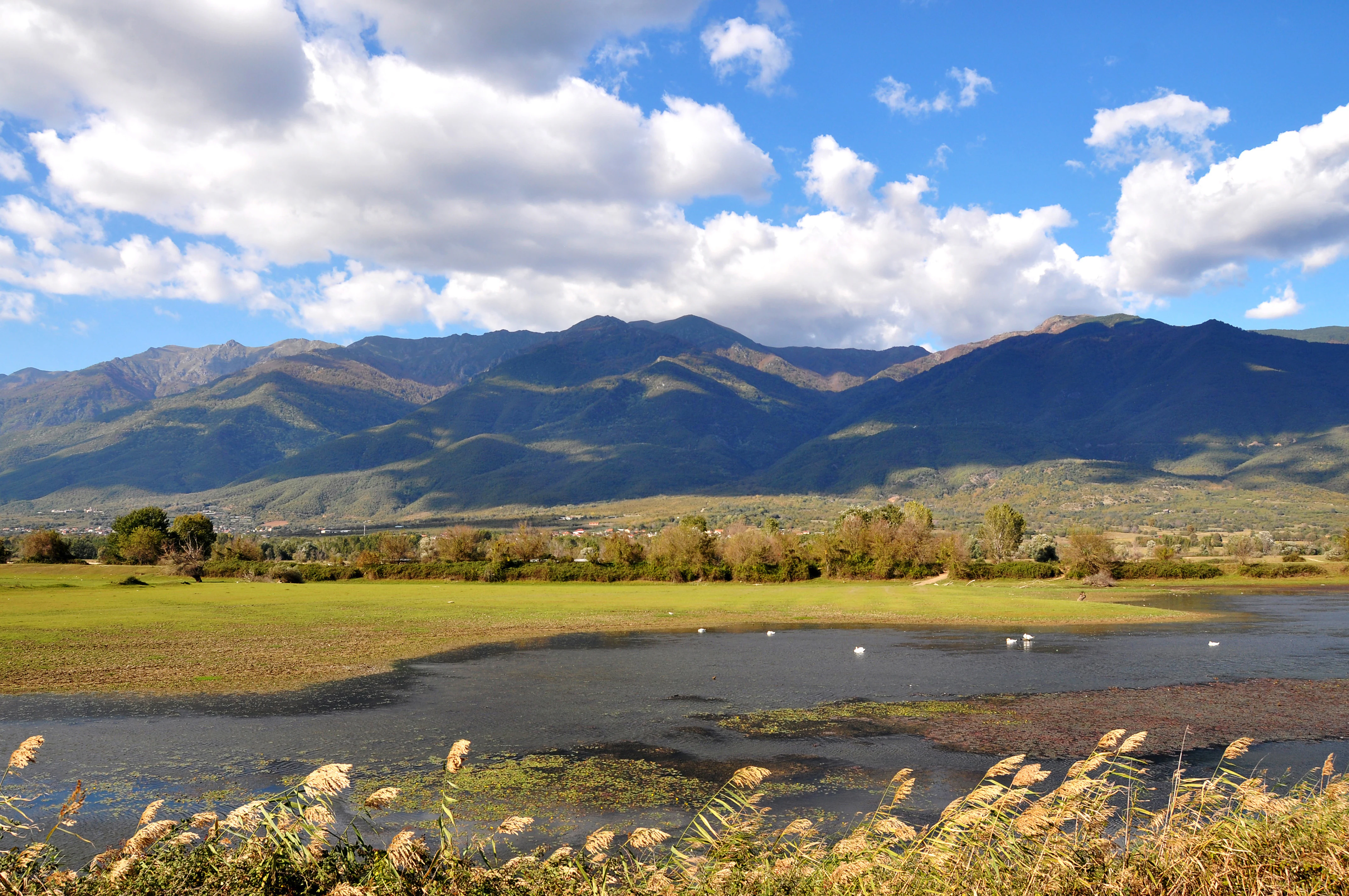
A landscape photograph of a wetland lake with reeds in the foreground, white birds on the water, green fields in the midground, and a large mountain range under a blue sky with clouds.
A view of the Lake Kerkini wetlands with a mountain range in the background.

Best time to visit Lake Kerkini

Season matters greatly at Lake Kerkini because the character of the lake shifts dramatically with the calendar of birds and water levels. Spring and early summer, roughly May into June, are widely regarded as a particularly rewarding period: many of the lake's waterbirds are breeding, colonies are active, and visitors can see herons, cormorants, pelicans, and storks at close quarters, while the surrounding hills come alive with wildflowers and fresh forest growth.

Autumn brings a different mood, as waterfowl begin arriving from northeastern Europe, with ducks, swans, and diving birds gathering on the lake. In colder winters, when conditions are harsh further north, Kerkini can host very large influxes of birds seeking to winter in its milder climate. For a balanced experience that combines breeding birdlife, mountain landscapes, and pleasant weather, late spring is often considered a strong choice.
Monthly climate preview

Long-term representative point measurements tracking monthly temperature ranges and precipitation patterns

Lake Kerkini Climate Normals, Annual Temperature and Precipitation Rhythm

Representative coordinate records show measured monthly temperature variations spanning from sub-zero winter minimums to elevated summer maximums alongside consistent precipitation rates. Detailed multi-year climate normals for Lake Kerkini provide complete monthly breakdowns for comprehensive temperature and precipitation analysis.
Annual mean14 °C
3 °C27 °C
Jan
Feb
Mar
Apr12°
May18°
Jun23°
Jul27°
Aug26°
Sep21°
Oct15°
Nov
Dec
Warmest month
July

26.6 °C

Coolest month
January

2.5 °C

Wettest month
December

2 mm/day

Driest month
August

0.9 mm/day

Park location guide

Geography guide, regional context, and park location map for Lake Kerkini

Lake Kerkini park geography, regions, and map view in Greece

Understand where Lake Kerkini sits in Greece through a broader geographic reading of the surrounding landscape, nearby location context, and its mapped position within the national park landscape.

How Lake Kerkini fits into Greece

Greece, officially the Hellenic Republic, is a country in Southeast Europe occupying the southern Balkans. It borders Albania, North Macedonia, Bulgaria, and Turkey, with coastlines on the Aegean, Ionian, and Mediterranean seas. The country has over 10 million people and is renowned for its ancient Greek heritage, philosophy, democracy, and the Olympic Games.

Wider geography shaping Lake Kerkini in Greece

Greece occupies the southern tip of the Balkan peninsula in Southeast Europe. It shares land borders with Albania to the northwest, North Macedonia and Bulgaria to the north, and Turkey to the east. The Aegean Sea lies to the east of the mainland, the Ionian Sea to the west, and the Sea of Crete and Mediterranean Sea to the south. The country spans thousands of islands across nine traditional geographic regions and has the longest coastline in the Mediterranean basin.

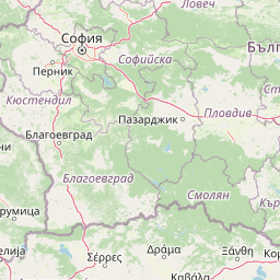
Map view of Lake Kerkini

Use this park location map to pinpoint Lake Kerkini in Greece, understand its exact geographic position, and read its mapped placement within the surrounding landscape more clearly.

Pigeon | © OpenStreetMap contributors

Location context for Lake Kerkini

Central Macedonia

Visualizing mountain backdrops, wetland habitats, and local wildlife across the basin

Lake Kerkini Photos and Protected Landscape Scenery

Visual records capture the distinctive topography of Lake Kerkini, highlighting expansive open water framed by the Belasica and Krousia mountain ranges. Examining field imagery reveals vital details regarding riverside forests, shallow marshlands, and the protected environment shared by migratory bird colonies and water buffalo.

A wide landscape view of a calm lake reflecting a blue sky with large white clouds, with a green hill on the left and a line of trees on the distant horizon.

A white Dalmatian Pelican with a long yellow beak and crest floating on rippled blue water.

A flock of pink and white flamingos with black wingtips flying low over a body of water, with some birds taking off or landing near the shore.

A flock of pelicans floating on a lake with mountains in the background under an orange sunset sky.

A Dalmatian pelican with white and black wings extended, touching down on the water surface.

A large group of white pelicans standing in a line in the shallow water of a lake, with green trees growing out of the water behind them and hills in the distance.

A wide landscape shot of a lake at sunset, featuring calm water reflecting the sky, mountains in the distance on the left, and a small port with trees and boats silhouetted against the sun on the right.

A landscape photograph of a wetland lake with reeds in the foreground, white birds on the water, green fields in the midground, and a large mountain range under a blue sky with clouds.

A wetland landscape showing a narrow winding stream flowing through green marshland with water lilies and aquatic plants, tall reeds in the midground, and a dense line of trees under a clear blue sky

A wide shot of a lake with a white pelican swimming in the foreground, a small wooden boat with two people in the midground, and mountains in the distance.

A wide panoramic photograph showing a calm lake with a shoreline in the foreground and a large mountain range in the background under a cloudy sky.

A paved road curves towards a large concrete dam with multiple spillway gates, set against a backdrop of green hills and a blue sky with clouds.

A landscape photograph showing a dense cluster of green trees on a grassy bank next to a lake, with their reflection visible in the water below and hills in the background under a blue sky with clouds.

Several pelicans floating on a calm lake with one pelican in the center spreading its wings, against a backdrop of hazy hills.

Vertical view of dark wooden fishing boats docked on a calm lake surface, with a tree-lined shore and blue sky in the background.

A wide landscape shot of a lake with tall brown reeds in the foreground and midground, white birds floating on the water, and large hazy mountains in the distance under a blue sky with white clouds. Tree branches frame the left side.

Park atlas

Compare adjacent wetland habitats, mountain ranges, and regional protected landscapes

Explore Parks Near Lake Kerkini and Surrounding Protected Natural Areas

Visitors exploring Lake Kerkini can examine nearby national parks and protected areas across the surrounding region. Regional comparisons reveal connected migratory flyways and contrasting mountain terrain.
Watercolor illustration of green mountains and a lake with trees
National parkBlagoevgrad Province
About 52 km away#1 closest

Northeast

Pirin National Park: Protected Area and Regional Geographic Context in Bulgaria

Explore Pirin National Park's mapped boundaries and landscape.

Pirin National Park serves as a vital national park entity within the atlas of Blagoevgrad Province, Bulgaria. This page details its protected landscape, offering a structured view of its geographic setting and mapped terrain. Users can investigate the park's specific identity and its relation to the surrounding regional geography, providing essential context for understanding protected areas and natural landscapes within a comprehensive map-driven framework.

Area
403.56 km²
Established
1962
IUCN
II
Relief
Mountain
A soft watercolor illustration featuring a winding river flowing through green wetlands towards gentle rolling hills under a pale pink and light orange sky.
National parkGreece
About 62 km away#2 closest

South

Parc national des lacs Korónia, Vólvi et du Témpi macédonien: Landscape and Map Atlas

Protected wetland basins and river gorge terrain in northern Greece

Spanning 159 square kilometers, this national park protects essential Mediterranean wetland habitats. Examine the unique intersection of Lake Korónia, the expansive Lake Vólvi, and the Richios River gorge that shapes the ecological character of this prominent Macedonian protected area.

Area
159.28 km²
Established
2004
IUCN
VI
Relief
Lowland
Watercolor painting of a mountainous landscape with a lake and green fields
National parkBulgaria
About 82 km away#3 closest

North

Rila National Park: Bulgaria's Largest National Park with Alpine Terrain and Glacial Lakes

Explore mapped boundaries and protected landscape features.

Rila National Park, situated in Bulgaria's Rila mountain range, stands as the country's largest national park and a vital protected landscape. Its territory is characterized by dramatic glacial topography, including the iconic Seven Rila Lakes, and ascends to Musala Peak, the highest summit in the Balkan Peninsula. This atlas entry details the park's extensive mapped boundaries and unique ecosystems, emphasizing its importance for understanding regional geography and protected area networks.

Area
810.46 km²
Established
1992
IUCN
II
Relief
Mountain
Watercolor depiction of a river delta with green fields, a winding river, wildflowers, and distant hills
National parkCentral Macedonia
About 87 km away#4 closest

Southwest

Axios Delta National Park: Central Macedonia's Premier Protected Wetlands and Bird Sanctuary

Mapping the unique geography of this vital European bird migration corridor.

Axios Delta National Park is a significant protected wetland located in Central Macedonia, Greece, renowned for its role as a critical stopover and breeding ground for countless bird species along the East Atlantic Flyway. The park's landscape is shaped by the Axios, Haliacmon, Loudias, and Gallikos river deltas, creating a dynamic mosaic of lagoons, reedbeds, and coastal dunes. As a Ramsar site and Natura 2000 network area, it highlights the importance of understanding mapped protected landscapes and their regional geographic context for conservation efforts. Explore the distinct natural features and ecological significance of this unique delta.

Area
338 km²
Established
2009
IUCN
VI
Relief
Lowland
Watercolor illustration showing mountains, river, and forested area
National parkGreece
About 115 km away#5 closest

East

Rodopi Mountain Range National Park: Greece's Largest Protected Forest Landscape Explorer

Mapped boundaries, old-growth ecosystems, and Balkan geography.

Rodopi Mountain Range National Park is a critical protected forest area in Greece, safeguarding one of Europe's last primeval forests, the Frakto Virgin Forest. As the nation's largest woodland conservation site, it showcases remarkable biodiversity and complex mountain terrain, from low-lying forests to subalpine meadows. This page provides detailed mapping context and geographic specifics for understanding this unique protected landscape and its ecological significance within the Rhodope Mountains.

Area
1,731.5 km²
Established
2009
IUCN
VI
Relief
Mountain
Watercolor painting of a mountain range, pine trees, and a small stream in the foreground against a light, misty background.
National parkThessaly
About 141 km away#6 closest

Southwest

Olympus National Park: Protected Mountain Landscapes and Geographic Mapping of Northern Greece

High mountain terrain, forest zones, and protected boundaries

Olympus National Park preserves the towering summit of Mount Olympus and its surrounding canyons. This record highlights the park's geologic structure, its diverse vegetation zones ranging from Bosnian pine to alpine grasslands, and its status as a cornerstone of the natural geography spanning the borders of Thessaly and Central Macedonia.

Area
39.88 km²
Established
1938
IUCN
II
Visitors
180K annual
Watercolor painting of a landscape with green trees, rolling hills, and distant mountains under a light sky
National parkMunicipality of Bitola
About 151 km away#7 closest

West

Pelister National Park: North Macedonia's Oldest National Park and Alpine Protected Landscape

Explore unique glacial features and endemic forests within Municipality of Bitola.

Pelister National Park, a pioneering protected area in North Macedonia, offers a rich tapestry of alpine geography and unique geological formations. This page provides detailed information on the park's landscape, including its dramatic mountain massif within Municipality of Bitola, the rare Macedonian pine forests, the striking 'stone rivers' formed by ancient glacial processes, and the serene Pelister Eyes glacial lakes. Discover the park's mapped boundaries and its significance as a conservation heritage site within the Balkan Peninsula.

Area
171.5 km²
Established
1948
IUCN
II
Visitors
30K annual
Watercolor painting depicting a wide, soft-focus view of marshland, low-lying green vegetation, and distant purple mountains under a clear sky.
National parkEastern Macedonia and Thrace
About 168 km away#8 closest

East

Parc national de Macédoine-Orientale-et-Thrace: Wetland Atlas and Geographic Boundaries

Coastal lagoons and river delta protected landscapes

Gain insight into the ecological and geographic structure of Parc national de Macédoine-Orientale-et-Thrace. This protected area encompasses a complex mosaic of river deltas, shifting saline lagoons, and remnant riparian forests that anchor the natural landscape of Eastern Macedonia and Thrace.

Area
929.47 km²
Established
2008
IUCN
V
Relief
Lowland

Common questions about visiting, size, designation, and location context for Lake Kerkini

Lake Kerkini FAQs for park facts, access, geography, and protected area context

Find quick answers about Lake Kerkini, including protected-area facts, park geography, trail and visitor context, and how the park fits into its surrounding country and regional landscape.
MoriAtlas Explorer

Continue Your Protected Areas Search Across the Global Atlas

Deepen your exploration by continuing the structured search for national parks and protected areas worldwide. Utilize the comprehensive filtering capabilities to compare different conservation landscapes and refine your understanding of global park geography. Discover more about the distribution and characteristics of protected natural areas.

Global natural geography