Mori Atlas logo
National parkRodopi Mountain Range National Park

Discover mapped boundaries, old-growth ecosystems, and exceptional biodiversity in the Rhodope Mountains.

Rodopi Mountain Range National Park: Greece's Premier Protected Forest Landscape Atlas

(Εθνικό Πάρκο Οροσειράς Ροδόπης)

Rodopi Mountain Range National Park represents the largest and most ecologically significant forest ecosystem in Greece, a sprawling protected landscape of approximately 173,000 hectares. This national park safeguards unique old-growth forests, including the rare Frakto Virgin Forest, and harbors exceptional biodiversity driven by its position as a biogeographical crossroads. Explore its mapped boundaries and diverse terrain, from valley forests to subalpine meadows, offering critical insight into the natural geography of the Balkan region.

national parkprotected forestold-growth forestmountain landscapebiodiversity hotspotlarge mammals
Stylized illustration of a waterfall in a mountainous area with autumn-colored trees and a river

Rodopi Mountain Range National Park

National park

Park overview

Structured park overview, official facts, and landscape profile for Rodopi Mountain Range National Park

Rodopi Mountain Range National Park park facts, protected area profile, and essential visitor context
Review the core facts for Rodopi Mountain Range National Park, including designation, size, terrain, visitor scale, habitats, and operating context in one park-focused overview.

About Rodopi Mountain Range National Park

Rodopi Mountain Range National Park occupies a distinctive position in Greece's protected area network as the country's largest forest-protected landscape. The park spans the central-west massif of the Greek Rhodope Mountains, extending from the northern foothills bordering Bulgaria southward to the slopes of Mount Falakro and along the Nestos River corridor. This vast expanse of mountainous terrain encompasses deep valleys, steep forested slopes, cascading waterfalls, and open meadow systems that together create a complex and ecologically varied landscape.

The park's establishment in 2009 marked a significant milestone in Greek conservation, formalizing protection for forest ecosystems that had long been recognized for their ecological significance. The management body is based in Mesochori, a village in the Drama regional unit, from which conservation activities and visitor management are coordinated. The park's boundary design reflects ecological rather than purely administrative considerations, encompassing watersheds and habitat corridors that support viable populations of large mammals and other species requiring extensive territory.

What distinguishes Rodopi from other Greek protected areas is the extraordinary intactness of its forest cover. Approximately 85% of the park's area is forested, with extensive tracts of relatively unmodified woodland providing habitat for species requiring old-growth conditions. The Frakto Virgin Forest, located within the park's boundaries, represents one of Europe's most significant remaining old-growth forest ecosystems, containing trees that have never been harvested and supporting ecological processes that have operated without human intervention for centuries.

Quick facts and research context for Rodopi Mountain Range National Park

Rodopi Mountain Range National Park covers roughly 173,000 hectares in Eastern Macedonia and Thrace, making it the largest national park in Greece by forest area. The park was established in 2009 under IUCN Category VI (protected area with sustainable use of natural resources) and is managed by the National Forest Department of the Greek Ministry of Agricultural Development. The park lies along the Greek-Bulgarian border, extending from the northeastern slopes of Mount Falakro northward to the border region near Xanthi. It encompasses portions of the Balkan mixed forests and Rodope montane mixed forests ecoregions. The park contains four distinct vegetation zones and supports exceptional biodiversity including 827 plant species, 57 mammal species, 139 bird species, and 180 Lepidoptera species representing more than 75% of all butterfly species recorded in Greece.

Park context

Deeper park guide and search-rich context for Rodopi Mountain Range National Park

Rodopi Mountain Range National Park history, landscape, wildlife, and travel context
Explore Rodopi Mountain Range National Park through its history, landscape character, ecosystems, wildlife, conservation priorities, cultural context, and seasonal travel timing in a structured park guide built for atlas discovery and search intent.

Why Rodopi Mountain Range National Park stands out

Rodopi Mountain Range National Park is especially known for its extensive old-growth forests and exceptional biodiversity. The Frakto Virgin Forest stands as one of Europe's last remaining primeval forests, a rare ecosystem where massive old-growth trees have never been logged. The park protects the southernmost occurrence of spruce forests in Europe, representing the ecological limit of this boreal species. It hosts significant populations of brown bears and grey wolves, and serves as a critical habitat for the endangered Egyptian vulture and the vulnerable Greek tortoise. The park is also remarkable for its Lepidoptera diversity, containing 180 of Greece's 235 recorded butterfly and moth species, a remarkable concentration representing one of the richest lepidopteran faunas in the Balkans.

Waterfall cascading over rocks into a pool surrounded by forest and boulders
Waterfall in Partheno Dasos Fraktou Forest, Rodopi Mountain Range National Park

Rodopi Mountain Range National Park history and protected-area timeline

Rodopi Mountain Range National Park was established in 2009 through designation by the Greek government, creating formal protection for the forest ecosystems of the Rhodope Mountains in northeastern Greece. The establishment followed growing recognition of the region's exceptional ecological values and the need to coordinate conservation management across what had previously been a patchwork of smaller protected zones and forest reserves. The park's creation was also influenced by Greece's obligations under European Union environmental legislation, particularly the Habitats Directive, which required identification and protection of significant natural habitats and species.

Prior to national park designation, portions of the area had been protected under various classifications, including nature reserves and forest protection zones. The park's formation consolidated these designations and extended protection to additional areas of ecological significance. The management framework places the park under the authority of the National Forest Department within the Greek Ministry of Agricultural Development and Food, providing institutional continuity with Greece's long tradition of forest protection. The park's management plan emphasizes balancing conservation objectives with sustainable use of natural resources, consistent with its IUCN Category VI classification.

Rodopi Mountain Range National Park landscape and geographic character

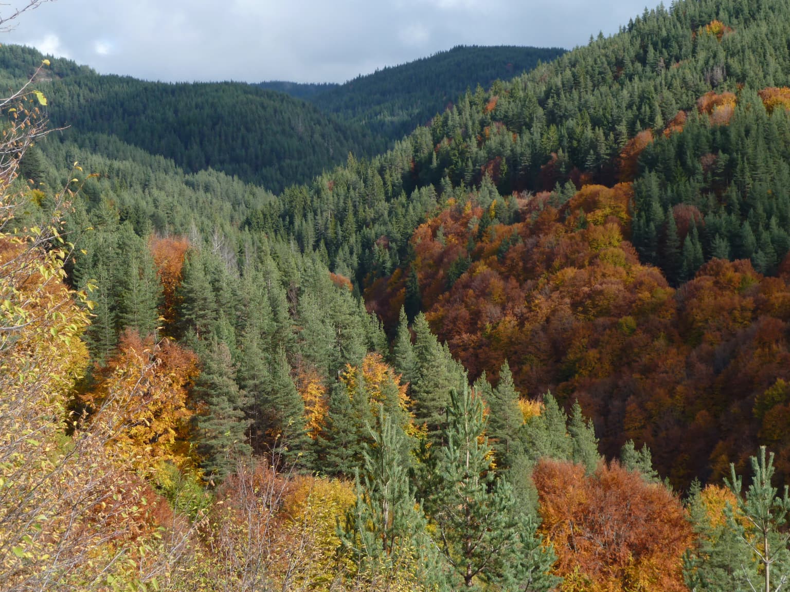
The Rodopi Mountain Range presents a landscape of substantial topographical complexity and visual diversity. The terrain consists of a series of parallel mountain ridges and valleys carved by ancient river systems, with elevations ranging from around 600 meters in the lower foothills to over 2,000 meters at the higher peaks. The park encompasses the western and central sections of the Greek Rhodope Mountains, a range characterized by rounded, forested peaks rather than the sharp alpine crests found in more northerly Balkan ranges.

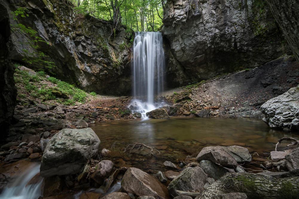
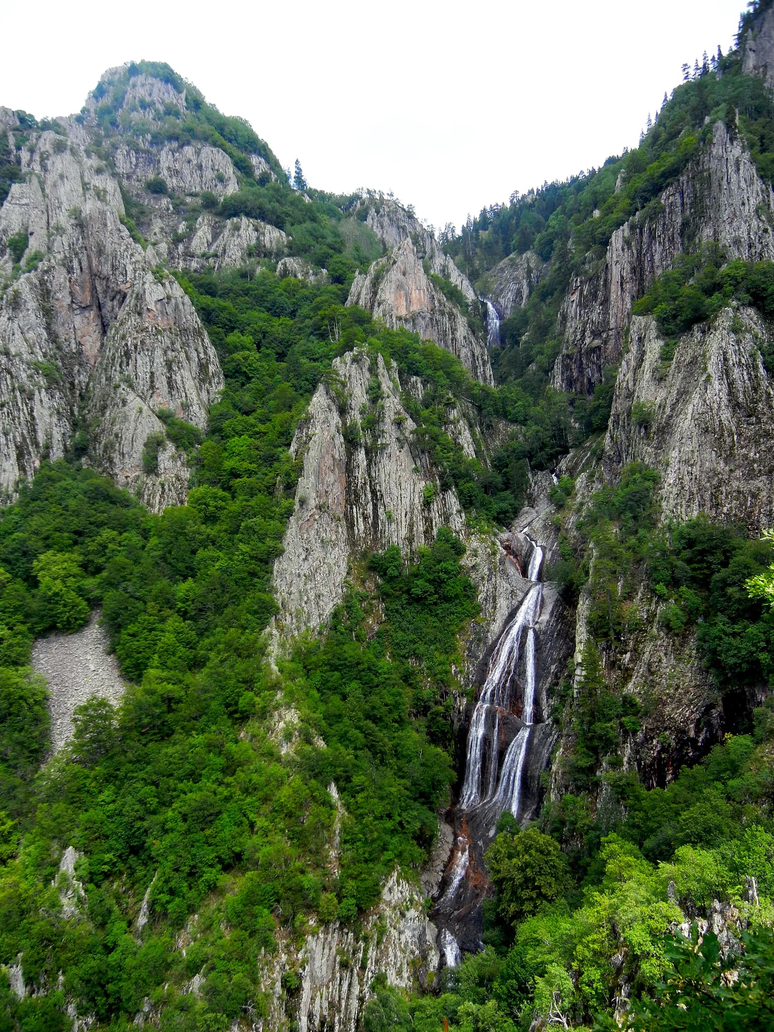
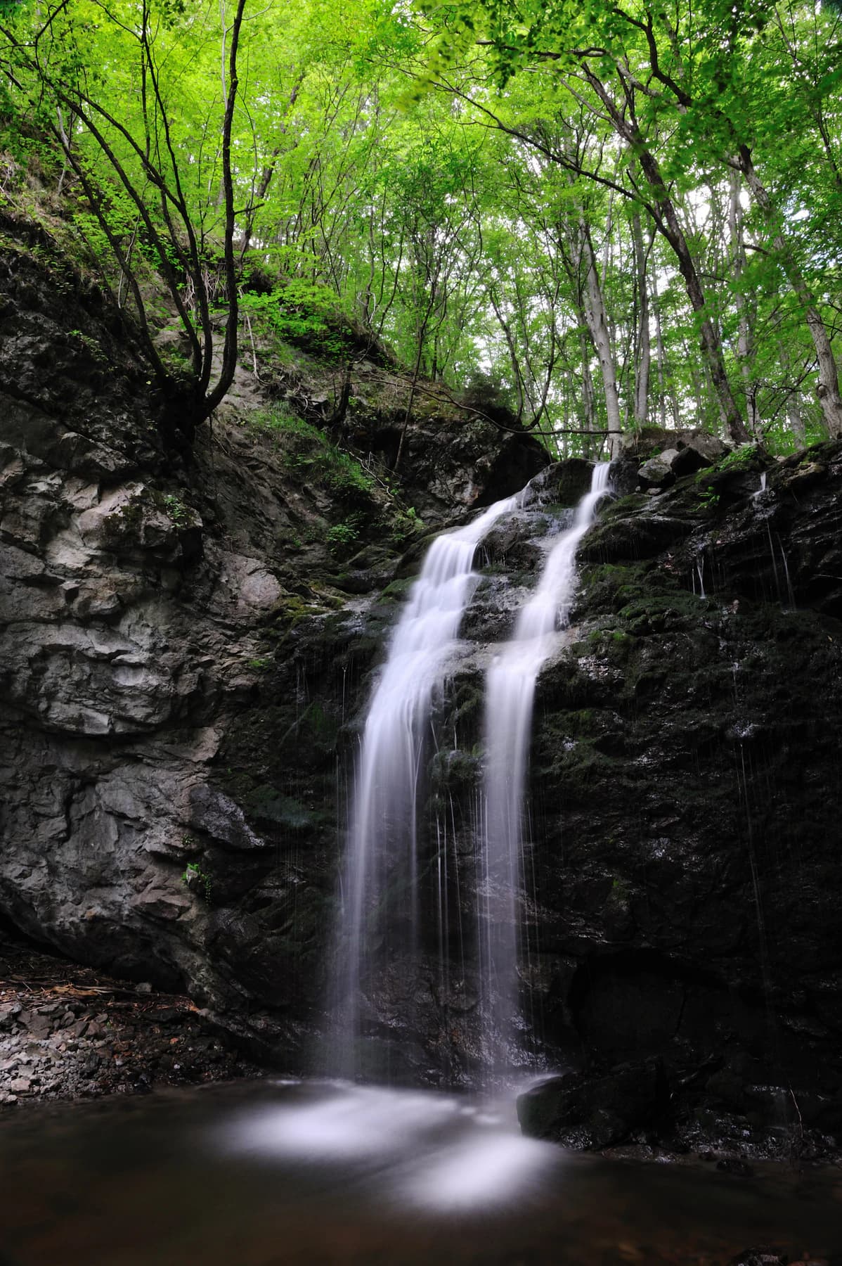
Throughout the park, steep-sided valleys descend from the main ridges, often containing permanent streams and seasonal watercourses that carry snowmelt and rainfall toward the Nestos River system. The landscape is punctuated by numerous waterfalls, particularly in the upper valley areas where streams drop over rocky ledges. The Livaditis waterfall represents one of the most notable cascades within the park. Dense forest cover dominates the middle and lower slopes, giving the landscape a predominantly green, heavily forested character. Rock outcrops and cliff faces occur throughout, providing contrast and supporting specialized rock-dwelling flora and nesting sites for birds of prey.

Waterfall flowing down rocky mountain cliffs amidst dense green forest
Waterfall cascading through rocky cliffs surrounded by dense forest in Rodopi Mountain Range National Park

Rodopi Mountain Range National Park ecosystems, habitats, and plant life

The ecological character of Rodopi Mountain Range National Park is defined by its extensive forests and the diversity of habitats they contain. The park lies at the intersection of two major European ecoregions: the Balkan mixed forests in the eastern portion and the Rodope montane mixed forests covering the remainder. This positioning creates a blending of vegetation types and supports species from both more northerly and more southerly distributions.

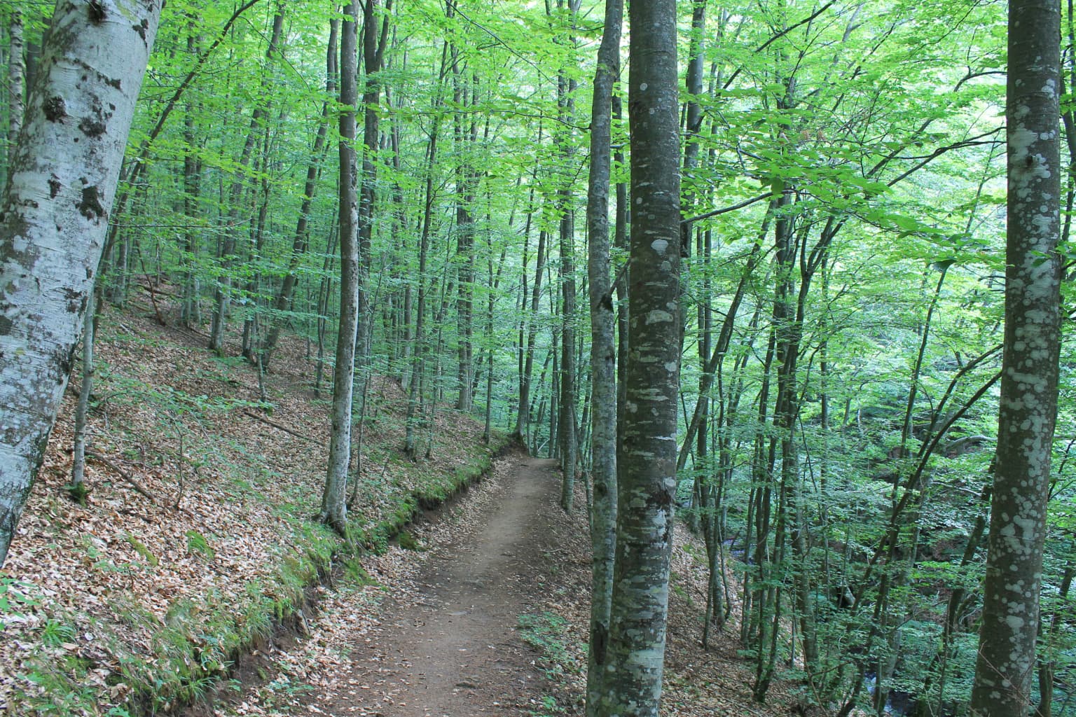
Four distinct vegetation zones characterize the park's ecological diversity. The lowest elevations support Mediterranean shrubland and mixed deciduous forests dominated by kermes oak, chestnut, and hornbeam. Ascending the slopes, these give way to extensive formations of European black pine and beech, the latter forming significant old-growth stands in the better-preserved areas. Higher still, Scots pine, birch, and spruce dominate, with spruce representing the southernmost occurrence of this typically boreal genus in Europe. The subalpine zone contains meadow and grassland communities interspersed with shrubby vegetation. The Frakto Virgin Forest represents a remarkable old-growth example of the beech and black pine forest type, containing trees of exceptional age and size that have never been logged.

Wide view of forested mountain valley with green and orange trees under partly cloudy sky
Autumn forest landscape in Rodopi Mountain Range National Park

Rodopi Mountain Range National Park wildlife and species highlights

The mammalian fauna of Rodopi Mountain Range National Park includes an impressive assembly of European large mammals. Brown bears and grey wolves persist in viable populations, representing apex predators that require extensive territories and intact ecosystems. The park also supports populations of red deer, roe deer, wild boar, and chamois at higher elevations. Smaller predators include the red fox, European wildcat, Eurasian otter, and European badger. In total, 57 mammal species have been recorded within the park.

The avifauna is equally notable, with 139 species documented including numerous birds of prey. Golden eagles, peregrine falcons, and Eurasian eagle-owl nest in the park's cliffs and forests. The Egyptian vulture, listed as endangered on the IUCN Red List, breeds here at the western edge of its global range. The park holds particular significance for two grouse species—the hazel grouse and the western capercaillie—representing one of the last areas in Greece where both species occur together. Reptile diversity includes 26 species, with the Greek tortoise (vulnerable) and adder representing notable conservation priorities. The rivers and streams support native fish communities including the endangered Phoxinus strymonicus.

Waterfall flowing over dark rocky cliff face surrounded by lush green trees and vegetation
Frakto Falls cascading over rocky cliff in dense forest

Rodopi Mountain Range National Park conservation status and protection priorities

Rodopi Mountain Range National Park serves as a core conservation area within Greece's Natura 2000 network, with large portions designated as Special Areas of Conservation under the EU Habitats Directive. The park's significance derives from its combination of extensive old-growth forest, populations of large mammals including bears and wolves, and exceptional biodiversity across multiple taxonomic groups. The designation of IUCN Category VI reflects the park's approach of combining biodiversity protection with sustainable resource management, acknowledging that local communities have historically and continue to utilize the landscape's natural resources.

The park's conservation value is amplified by its position as the largest contiguous forest area in Greece, providing habitat connectivity across an otherwise fragmented landscape. Many species recorded in the park are of European conservation concern, including the Egyptian vulnerable, Greek tortoise, and numerous Lepidoptera. The protection of the Frakto Virgin Forest carries particular international significance as one of Europe's last remaining unmodified forest ecosystems. Conservation challenges include managing human-wildlife interactions, particularly where large carnivores overlap with pastoral activities, and maintaining habitat connectivity across the park's boundary.

Rodopi Mountain Range National Park cultural meaning and human context

The Rhodope Mountains have been inhabited for millennia, and the landscape within Rodopi National Park contains evidence of human presence across different historical periods. Traditional villages scattered throughout the surrounding area have historically practiced pastoralism, small-scale agriculture, and forest resource use that shaped the cultural landscape. The park boundary deliberately includes some settled areas and agricultural land, reflecting the Category VI approach of integrating conservation with sustainable human activities.

The management of the park operates from Mesochori in the Drama regional unit, a village that represents the local communities whose lives are intertwined with the mountain landscape. The Greek naming of the park in Greek script—Εθνικό Πάρκο Οροσειράς Ροδόπης—reflects its identity as a Greek protected area. The region has historical connections to both Greek and Bulgarian cultural traditions, though the protected area itself is entirely within Greek territory. Contemporary management seeks to balance traditional land uses with conservation objectives, recognizing that the ecological values of the park are intertwined with the region's cultural history.

Dirt path through forest with tall trees, green foliage, and fallen leaves on ground
Dirt trail winding through dense forest in Rodopi Mountain Range National Park

Top sights and standout views in Rodopi Mountain Range National Park

Rodopi Mountain Range National Park stands as Greece's premier forest conservation area, protecting the largest and most biologically diverse woodland in the country. The Frakto Virgin Forest alone makes the park internationally significant, representing one of Europe's five most important unmodified forest ecosystems. The park's elevation gradient supports an exceptional diversity of forest types, from Mediterranean oak scrub at lower elevations through beech and black pine forests to the southernmost European spruce forests at higher altitudes. Large carnivores—brown bears and grey wolves—persist here in viable populations, testament to the ecological integrity of the landscape. The concentration of 180 Lepidoptera species represents an extraordinary butterfly and moth diversity, making the park a significant destination for understanding European forest entomology.

Best time to visit Rodopi Mountain Range National Park

The park can be visited throughout the year, with each season offering distinct experiences. Spring and early summer bring wildflower displays in the meadows and lower forest areas, with May and June offering ideal conditions for observing the park's rich insect fauna. The summer months provide the warmest conditions for hiking and exploring the higher elevations, though afternoon thunderstorms are common in the mountains. Autumn brings spectacular fall color as the deciduous trees turn, and this season offers excellent wildlife viewing opportunities as animals become more active during cooler temperatures. Winter transforms the landscape with snow on higher peaks, though some roads and trails may become impassable. The shoulder seasons of spring and autumn generally offer the most comfortable conditions for wildlife observation and forest exploration.

Park location guide

Geography guide, regional context, and park location map for Rodopi Mountain Range National Park

Rodopi Mountain Range National Park park geography, regions, and map view in Greece
Understand where Rodopi Mountain Range National Park sits in Greece through a broader geographic reading of the surrounding landscape, nearby location context, and its mapped position within the national park landscape.

How Rodopi Mountain Range National Park fits into Greece

Greece, officially the Hellenic Republic, is a country in Southeast Europe occupying the southern Balkans. It borders Albania, North Macedonia, Bulgaria, and Turkey, with coastlines on the Aegean, Ionian, and Mediterranean seas. The country has over 10 million people and is renowned for its ancient Greek heritage, philosophy, democracy, and the Olympic Games.

Wider geography shaping Rodopi Mountain Range National Park in Greece

Greece occupies the southern tip of the Balkan peninsula in Southeast Europe. It shares land borders with Albania to the northwest, North Macedonia and Bulgaria to the north, and Turkey to the east. The Aegean Sea lies to the east of the mainland, the Ionian Sea to the west, and the Sea of Crete and Mediterranean Sea to the south. The country spans thousands of islands across nine traditional geographic regions and has the longest coastline in the Mediterranean basin.

Map view of Rodopi Mountain Range National Park

Use this park location map to pinpoint Rodopi Mountain Range National Park in Greece, understand its exact geographic position, and read its mapped placement within the surrounding landscape more clearly.

Pigeon | © OpenStreetMap contributors

Location context for Rodopi Mountain Range National Park

Eastern Macedonia and Thrace

Explore the Diverse Habitats, Rugged Terrain, and Protected Character of Greece's Largest Forest Ecosystem.

Rodopi Mountain Range National Park Photos: Visualizing Greece's Extensive Forest Landscapes and Mountain Scenery
View comprehensive imagery to understand the unique old-growth forests, high mountain landscapes, and exceptional biodiversity that define Rodopi Mountain Range National Park in Greece. These visual references reveal the park's varied terrain, from ancient Frakto Virgin Forest ecosystems to river-carved valleys, offering clear insight into its conservation value.

Waterfall cascading over rocks into a pool surrounded by forest and boulders

A mountain slope covered in dense forest with autumn foliage in shades of orange, red, and green under a cloudy sky

Waterfall flowing down rocky mountain cliffs amidst dense green forest

Wide view of forested mountain valley with green and orange trees under partly cloudy sky

Waterfall flowing over dark rocky cliff face surrounded by lush green trees and vegetation

Grassy hillside with scattered rocks, trees, and yellow wildflowers under a clear blue sky

Dirt path through forest with tall trees, green foliage, and fallen leaves on ground

Park atlas

Explore the geographic context of surrounding protected areas, comparing diverse mountain landscapes across Greece and the wider Balkan region.

Discover Nearby National Parks and Protected Areas Around Rodopi Mountain Range National Park
Continue your exploration from Rodopi Mountain Range National Park by browsing other national parks and protected areas located within its geographic vicinity. Compare these diverse mountain landscapes to understand the regional spread of conservation efforts, revealing connected ecosystems and unique protected-area profiles.
Watercolor illustration of green mountains and a lake with trees
National parkBlagoevgrad Province

Pirin National Park: Protected Area and Regional Geographic Context in Bulgaria

Explore Pirin National Park's mapped boundaries and landscape.

Pirin National Park serves as a vital national park entity within the atlas of Blagoevgrad Province, Bulgaria. This page details its protected landscape, offering a structured view of its geographic setting and mapped terrain. Users can investigate the park's specific identity and its relation to the surrounding regional geography, providing essential context for understanding protected areas and natural landscapes within a comprehensive map-driven framework.

Area
403.56 km²
Established
1962
IUCN
II
Relief
Mountain
National park

Rila National Park: Bulgaria's Largest National Park with Alpine Terrain and Glacial Lakes

Explore mapped boundaries and protected landscape features.

Rila National Park, situated in Bulgaria's Rila mountain range, stands as the country's largest national park and a vital protected landscape. Its territory is characterized by dramatic glacial topography, including the iconic Seven Rila Lakes, and ascends to Musala Peak, the highest summit in the Balkan Peninsula. This atlas entry details the park's extensive mapped boundaries and unique ecosystems, emphasizing its importance for understanding regional geography and protected area networks.

Area
810.46 km²
Established
1992
IUCN
II
Relief
Mountain
National parkLovech Province

Central Balkan National Park: Bulgaria's Majestic National Park and Protected Landscape

Explore mapped alpine terrain and ancient forests in Lovech Province.

Central Balkan National Park is a significant protected area in Bulgaria, renowned for its stunning mountain geography and exceptionally well-preserved ancient beech forests. Located within Lovech Province, the park's landscape is defined by dramatic peaks, including Botev Peak, deep canyons, and alpine meadows, offering a rich context for geographical exploration and understanding its protected status. Its ecosystem health and ecological value are underscored by multiple nature reserves and its recognition as part of a UNESCO World Heritage Site.

Area
716.69 km²
Established
1991
IUCN
II
Relief
Mountain
National parkEastern Macedonia and Thrace

Dadia-Lefkimi-Soufli Forest National Park: Protected Landscape Atlas and Raptor Habitat

Mapped terrain and protected area context in Eastern Macedonia and Thrace.

This canonical entry for Dadia-Lefkimi-Soufli Forest National Park provides a structured atlas view of its protected landscape. Understand the park's geographic setting within Eastern Macedonia and Thrace, its mapped boundaries, and its significance as a critical sanctuary for raptors across Europe. Explore the diverse natural terrain that defines this protected area and its ecological importance.

Area
428 km²
Established
2006
IUCN
VI
Visitors
50K annual
National parkTurkey

Lake Gala National Park: A Key Protected Wetland Landscape in Turkey's Maritsa Delta

Discover its bird habitats and mapped geographic context.

Lake Gala National Park is a nationally significant protected area, designated in 2005 to conserve the unique wetland ecosystem of the Maritsa Delta. Encompassing the shallow lakes Pamuklu and Küçük Gala, this park spans approximately 6,090 hectares of diverse wetland and forest habitats. It is internationally recognized as a Ramsar site and serves as a critical sanctuary for over 160 bird species, making it a premier birdwatching destination in Turkey and an important locus for understanding protected landscapes within a regional geographic framework.

Area
60.9 km²
Established
2005
Relief
Lowland
Climate
Temperate
Watercolor depiction of a river delta with green fields, a winding river, wildflowers, and distant hills
National parkCentral Macedonia

Axios Delta National Park: Central Macedonia's Premier Protected Wetlands and Bird Sanctuary

Mapping the unique geography of this vital European bird migration corridor.

Axios Delta National Park is a significant protected wetland located in Central Macedonia, Greece, renowned for its role as a critical stopover and breeding ground for countless bird species along the East Atlantic Flyway. The park's landscape is shaped by the Axios, Haliacmon, Loudias, and Gallikos river deltas, creating a dynamic mosaic of lagoons, reedbeds, and coastal dunes. As a Ramsar site and Natura 2000 network area, it highlights the importance of understanding mapped protected landscapes and their regional geographic context for conservation efforts. Explore the distinct natural features and ecological significance of this unique delta.

Area
338 km²
Established
2009
IUCN
VI
Relief
Lowland
Protected areaTurkey

Ancient Troya National Park: A Mapped Protected Landscape with Deep Historical Significance

Explore the terrain and protected boundaries of this key Turkish heritage site.

Ancient Troya National Park offers a unique window into history, preserving the layers of the ancient city of Troy within its protected boundaries. Situated in Turkey, this park encompasses a significant archaeological site on a commanding hilltop, overlooking rolling Mediterranean terrain and coastal plains. Its landscape, characterized by fortified walls, gates, and the remnants of ancient structures, provides a rich context for understanding its mythological and historical importance. MoriAtlas provides detailed mapping and geographic context for this vital protected area, enhancing its atlas exploration value.

Established
1996
Relief
Lowland
Climate
Mediterranean
Access
Moderate access
Watercolor illustration of a coastal landscape with hills, trees, and a body of water
Marine protected area

National Marine Park of Alonnisos Northern Sporades: Protected Marine Landscape and Aegean Geography

Explore Greece's largest marine protected area and its vital ecosystems.

Investigate the National Marine Park of Alonnisos Northern Sporades, an extensive marine protected area situated in the northern Aegean Sea. This protected landscape is internationally significant for its role in conserving the Mediterranean monk seal and for its healthy Posidonia oceanica seagrass meadows. Understanding this park's geographic scope and its protected marine terrain offers crucial insights into Mediterranean island ecosystems and conservation efforts within the region.

Area
2,260 km²
Established
1992
IUCN
II
Relief
Mixed relief

Common questions about visiting, size, designation, and location context for Rodopi Mountain Range National Park

Rodopi Mountain Range National Park FAQs for park facts, access, geography, and protected area context
Find quick answers about Rodopi Mountain Range National Park, including protected-area facts, park geography, trail and visitor context, and how the park fits into its surrounding country and regional landscape.
MoriAtlas Explorer

Continue Your Protected Areas Search Across the Global Atlas

Deepen your exploration by continuing the structured search for national parks and protected areas worldwide. Utilize the comprehensive filtering capabilities to compare different conservation landscapes and refine your understanding of global park geography. Discover more about the distribution and characteristics of protected natural areas.

Global natural geography