Mori Atlas logo
National parkAxios Delta National Park

Mapping the unique delta landscape and rich biodiversity of this vital protected area in Central Macedonia.

Axios Delta National Park: Protected Wetlands, Bird Migration Hub, and Geographic Atlas

(Axios-Loudias-Aliakmonas Delta National Park)

Axios Delta National Park represents a critical protected landscape situated in Central Macedonia, Greece. This national park is renowned for its sprawling coastal wetland complex, serving as a major European hub along the East Atlantic Flyway. Its unique geography features a mosaic of lagoons, reedbeds, and sand dunes formed by the confluence of the Axios, Haliacmon, Loudias, and Gallikos rivers. Discover the mapped boundaries and ecological significance of this ornithologically vital delta region.

WetlandsBird MigrationRamsar SiteNatura 2000Coastal DeltaReedbeds
Illustration showing a mountain range with a waterfall, winding river, and pine forests under a bright sun with clouds.

Axios Delta National Park

National park

Park overview

Structured park overview, official facts, and landscape profile for Axios Delta National Park

Axios Delta National Park park facts, protected area profile, and essential visitor context
Review the core facts for Axios Delta National Park, including designation, size, terrain, visitor scale, habitats, and operating context in one park-focused overview.

About Axios Delta National Park

Axios Delta National Park represents one of Greece's most significant coastal wetland ecosystems, protecting a complex network of river deltas, lagoons, marshes, and estuaries where the Axios, Haliacmon, Loudias, and Gallikos rivers meet the Thermaic Gulf. The park's location in Central Macedonia places it along one of Europe's primary bird migration corridors, endowing it with extraordinary ecological value that extends far beyond its national borders. Originally designated for Ramsar protection in 1971, the area was formally established as a national park in 2009, cementing its status as a cornerstone of Greek environmental conservation.

The park's geography is defined by the dynamic interplay between freshwater river systems and the saline waters of the Aegean Sea. The Axios Delta, formed where the river's silt-laden waters slow and spread before entering the gulf, creates extensive reedbeds and mudflats that support prodigious quantities of aquatic life. Adjacent lagoons including Kalochori and Alyki Kitrous provide sheltered shallow waters ideal for fish, invertebrates, and waterfowl. The Gallikos estuary and the Nea Agathoupoli wetland add further ecological diversity to the protected area. Throughout the delta, sand dunes fringe the coastline, providing specialized habitat for rare reptile species.

The proximity of the park to Thessaloniki—just 10 kilometers at its nearest point—creates both opportunities and challenges. The urban area provides a nearby population center for environmental education and recreational access, while also exerting development pressure on surrounding lands. The park falls within five regional units: Pieria, Imathia, Pella, Kilkis, and Thessaloniki, reflecting its extensive geographic footprint across the Macedonian plain. This multi-jurisdictional character underscores the complexity of managing such a ecologically important yet accessible protected area.

The park's international recognition reflects its exceptional biodiversity. As a Ramsar Convention site, it contributes to the global network of wetlands of significance, particularly for waterbird conservation. Its designation as an Important Bird Area identifies it as crucial habitat for globally threatened bird species. Inclusion in the Natura 2000 network connects it to Europe's broader conservation framework aimed at preserving biodiversity across the continent.

Quick facts and research context for Axios Delta National Park

Axios Delta National Park occupies 338 km² of coastal wetland on the Thermaic Gulf in Central Macedonia, Greece. The protected area spans the deltas of four major rivers—Axios, Haliacmon, Loudias, and Gallikos—within five regional units. It holds IUCN Category VI status for sustainable use of natural resources. The park is one of Europe's most important wetland bird habitats, with 299 species recorded, including globally significant populations of Dalmatian pelican, greater flamingo, and pygmy cormorant. The area supports 370 plant species, 40 mammal species, 19 reptile species, 8 amphibian species, and at least 38 freshwater fish species. Traditional land uses including rice cultivation, mussel farming, and salt production continue within the park boundaries.

Park context

Deeper park guide and search-rich context for Axios Delta National Park

Axios Delta National Park history, landscape, wildlife, and travel context
Explore Axios Delta National Park through its history, landscape character, ecosystems, wildlife, conservation priorities, cultural context, and seasonal travel timing in a structured park guide built for atlas discovery and search intent.

Why Axios Delta National Park stands out

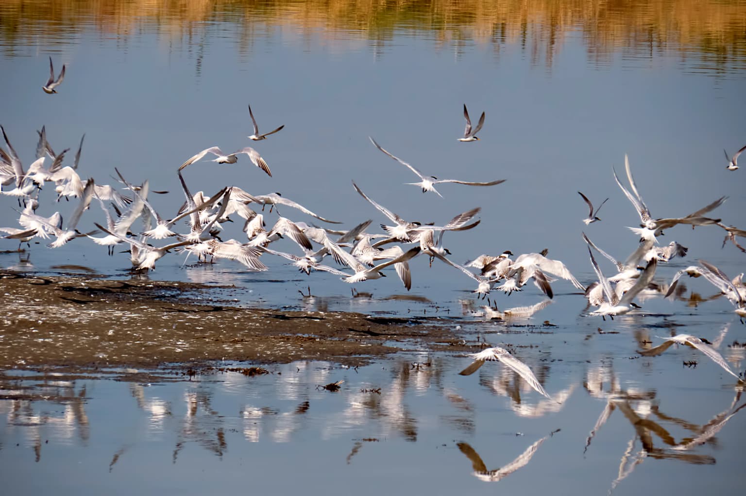
Axios Delta National Park is best known as one of the most ornithologically important wetlands in Europe. The park hosts remarkable concentrations of breeding and migratory waterbirds, including the largest European population of the vulnerable Dalmatian pelican and substantial flocks of greater flamingos that congregate in the shallow lagoons. The sand dunes between Alyki Kitrous lagoon and the Aegean Sea support Europe's largest and world's most densely populated colony of Hermann's tortoises. The park is also notable for its population of Axios horses, a unique feral breed descended from farm animals abandoned in the 1960s that now roam freely within the delta ecosystem. The delta serves as a critical staging area along the East Atlantic Flyway, making it a premier destination for birdwatching and wetland ecology study.

Birds flying above calm water with reflections in the wetland
Flock of birds in flight over wetland waters of Axios Delta National Park

Axios Delta National Park history and protected-area timeline

The Axios Delta area has supported human settlement and activity for millennia, with the fertile Macedonian plain attracting agricultural communities since antiquity. The rivers that traverse this landscape—the Axios (known historically as the Vardar), the Haliacmon (or Aliakmonas), and the Loudias—carried rich sediments that formed the extensive delta wetlands. Historical accounts from travelers such as William Martin Leake in the 19th century documented the area's wildlife, including wild boars that are now locally extinct.

Modern conservation efforts began in 1971 when the delta was designated as a Ramsar Wetland of International Importance, recognizing its global significance for waterbird conservation. This early recognition came amid growing awareness of the ecological value of Mediterranean wetlands, many of which had been extensively drained for agriculture in the preceding decades. The Ramsar designation provided the first layer of international protection, establishing the framework for ongoing conservation of the area's wetland ecosystems.

Formal establishment as Axios Delta National Park came in 2009, elevating the protection status and providing a clearer management framework for the diverse ecosystems within the delta. The park's official name, Axios-Loudias-Aliakmonas Delta National Park, reflects the inclusion of multiple river systems beyond the Axios proper. This expansion acknowledged that the ecological integrity of the delta system depends on the interconnected functioning of all the rivers that feed into the Thermaic Gulf through this area. The national park designation placed the area within Greece's system of protected areas, establishing it as IUCN Category VI—recognizing it as a protected area where sustainable use of natural resources is permitted alongside conservation objectives.

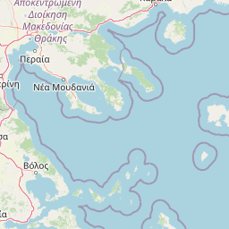
Axios Delta National Park landscape and geographic character

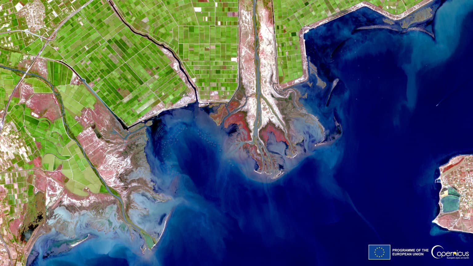
The Axios Delta landscape is characterized by a flat, low-lying terrain where rivers have deposited layers of sediment over millennia, creating a complex mosaic of aquatic and terrestrial habitats. The delta surface barely rises above sea level, with most of the area occurring at elevations of just a few meters above the water table. This topography creates ideal conditions for wetland formation, as water drains slowly across the flat landscape, allowing extensive marshes, lagoons, and reedbeds to develop.

The river channels themselves form the backbone of the landscape, their braided courses spreading across the delta as they approach the sea. The Axios River, originating in the mountains of North Macedonia and Yugoslavia, carries substantial sediment loads that have built out the delta coastline over time. Similar sediment contributions from the Haliacmon (Greece's longest river) and the Loudias create a continually evolving landscape where river courses shift and new land emerges. The Gallikos River, though smaller, adds its own deltaic contribution to the western portion of the park.

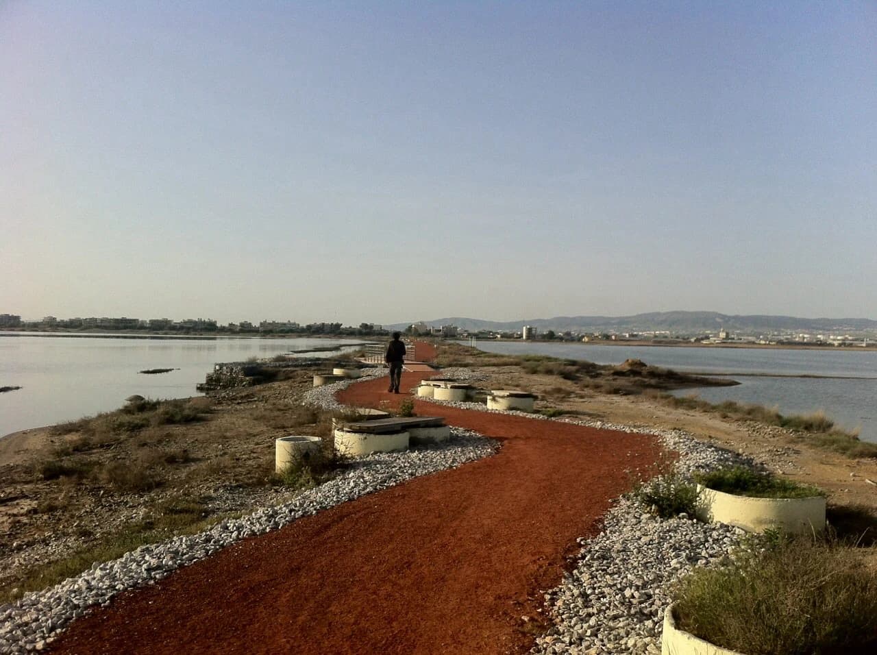
Lagoons and coastal wetlands punctuate the interface between river and sea. The Kalochori lagoon near Thessaloniki and the Alyki Kitrous lagoon to the north provide sheltered, shallow bodies of brackish water separated from the open gulf by narrow landform barriers. These lagoons support rich aquatic communities and serve as critical feeding and resting areas for migratory waterfowl. Between the lagoons and the Aegean Sea, sand dunes have formed along parts of the coastline, creating a distinct habitat type characterized by mobile sand, specialized pioneer plants, and the rare reptile populations that depend on this warming, well-drained substrate. The entire delta lies within the Aegean and Western Turkey sclerophyllous and mixed forests ecoregion, though the wetland areas themselves support quite different vegetation assemblages dominated by reeds, rushes, and halophytic plants.

Water buffalos grazing in a grassy field with sunlight rays filtering through clouds
Water buffalos grazing under sunbeams in a grassy field

Axios Delta National Park ecosystems, habitats, and plant life

The Axios Delta supports an extraordinary diversity of ecosystems within its 338 square kilometers, making it one of Greece's most ecologically significant protected areas. The wetland complex includes several distinct habitat types that together create a highly productive environment supporting hundreds of species. Reedbeds dominate large areas, with common reeds and bulrushes forming dense stands that provide shelter and nesting sites for birds, amphibians, and mammals. The lagoons support beds of submerged aquatic vegetation and, in their more saline sections, extensive communities of glassworts—succulent halophytic plants adapted to brackish conditions.

The vegetation across the park reflects the gradient from fully freshwater river channels through brackish lagoons to fully saline coastal waters. Riverbanks support galleries of European alders, elms, and willows that stabilize sediments and provide shade for aquatic organisms. In more upland areas within the delta, patches of deciduous woodland occur, though these are limited in extent. The sand dunes support distinctive psammophytic vegetation adapted to sandy, nutrient-poor conditions. Across all habitat types, the park records approximately 370 plant species, representing the typical flora of northern Greek wetlands and coastal zones rather than any significant endemic or rare plant community.

The ecological productivity of the delta stems from the constant flow of nutrients from the river systems into the coastal zone. The Axios, Haliacmon, and Loudias rivers all carry agricultural runoff and natural sediments that enrich the coastal waters, supporting the extraordinary mussel farming industry that operates along the park's coastline. This nutrient input drives the entire food web, from microscopic phytoplankton through invertebrate populations to the fish and birds that feed upon them. The mixing of fresh and salt water in the delta creates a highly variable environment that many species have evolved to exploit, making the area particularly rich in both freshwater and marine organisms.

Satellite image of Axios Delta National Park in Greece with river deltas, coastal wetlands, agricultural fields, and urban areas
Satellite view of Axios Delta National Park showing river deltas and coastal wetlands

Axios Delta National Park wildlife and species highlights

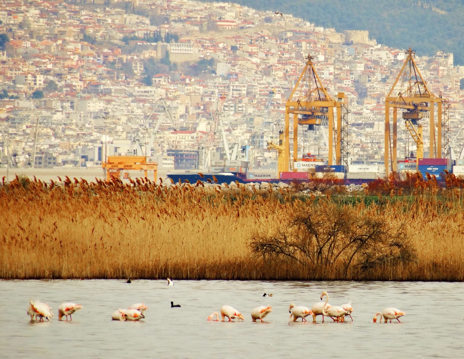
The wildlife of Axios Delta National Park is remarkable for its diversity and abundance, particularly among bird populations that make this delta one of Europe's most important wetland bird habitats. The park has recorded 299 bird species—astonishingly representing 66% of all bird species ever observed in Greece—making it a destination of global significance for ornithologists and birdwatchers. Waterbirds dominate the avifauna, with colonial nesting species including Dalmatian pelicans, greater flamingos, and various herons and egrets forming large breeding colonies in the reedbeds and islands within the lagoons.

The Dalmatian pelican holds particular importance, as the park supports one of the largest breeding populations of this vulnerable species in Europe. These massive waterbirds nest in the reedbeds and feed in the shallow lagoon waters, their distinctive white plumage and pendulous throat pouches making them unmistakable. Greater flamingos congregate in even larger numbers, their pink plumage creating striking visual displays as they feed on brine shrimp and other invertebrates in the lagoon shallows. The park also supports significant populations of pygmy cormorant, glossy ibis, squacco heron, collared pratincole, and Mediterranean gull, among many other species.

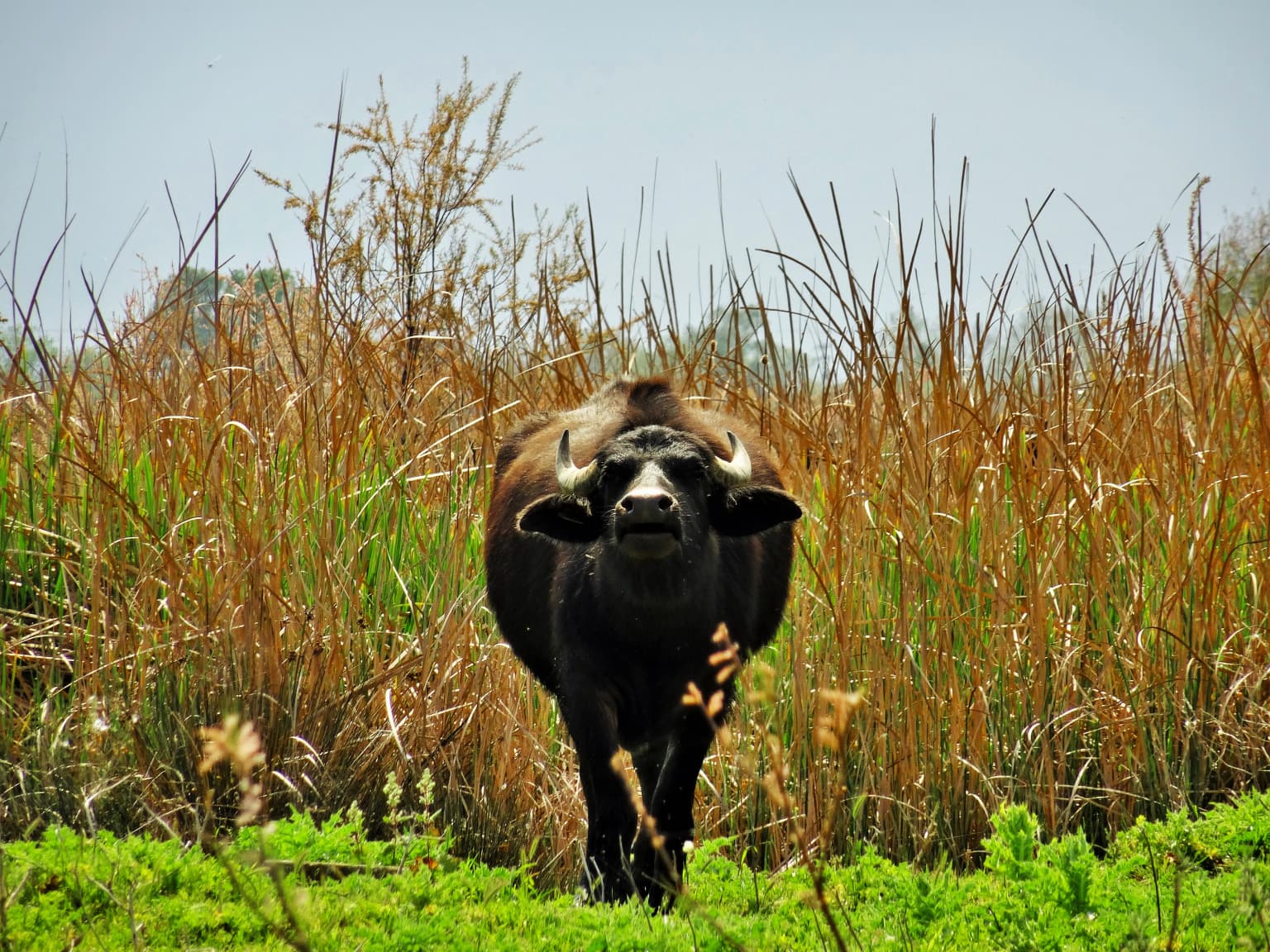
Mammal populations include 40 species, with the grey wolf, Eurasian badger, European wildcat, golden jackal, red fox, and Eurasian otter representing the larger predators and mesocarnivores. Fifteen species of bats exploit the abundant insect populations, while rodents including the forest dormouse and endangered European ground squirrel occupy terrestrial niches. The park's most distinctive mammalian resident is the Axios horse, a feral breed found nowhere else in the world, descended from domestic animals abandoned by farmers in the early 1960s and now integrated into the delta ecosystem. Reptiles include 19 species, with the two tortoise species—Greek tortoise and Hermann's tortoise—being particularly notable, the latter supporting Europe's largest and the world's most dense population in the sand dunes. Eight amphibian species and at least 38 freshwater fish species round out the vertebrate diversity, while invertebrates include the critically endangered noble pen shell (Pinna nobilis) and numerous dragonfly, butterfly, and beetle species.

Person walking on red gravel boardwalk surrounded by water, with concrete planters and vegetation along the sides
Boardwalk at Kalochori Lagoon, Axios Delta National Park

Axios Delta National Park conservation status and protection priorities

Axios Delta National Park occupies a central position in European wetland conservation, its multiple international designations reflecting the exceptional ecological value of this coastal delta system. The park's Ramsar status, dating to 1971, commits Greece to maintaining the ecological character of the wetland and ensuring its sustainable use for waterbird conservation. As an Important Bird Area, the site is recognized by BirdLife International as crucial habitat for globally threatened bird species, requiring specific conservation attention to preserve the conditions that support these populations.

The Natura 2000 designation integrates the park into Europe's primary conservation network, providing a framework for protecting not just the site itself but also the broader ecological processes that depend on it. The network aims to maintain biodiversity across the continent by protecting representative samples of different habitat types and the species they support. For the Axios Delta, this means ensuring that the wetland complex continues to function as a productive ecosystem capable of supporting the hundreds of bird species that depend on it, the fish populations that sustain them, and the invertebrate communities that form the base of the food web.

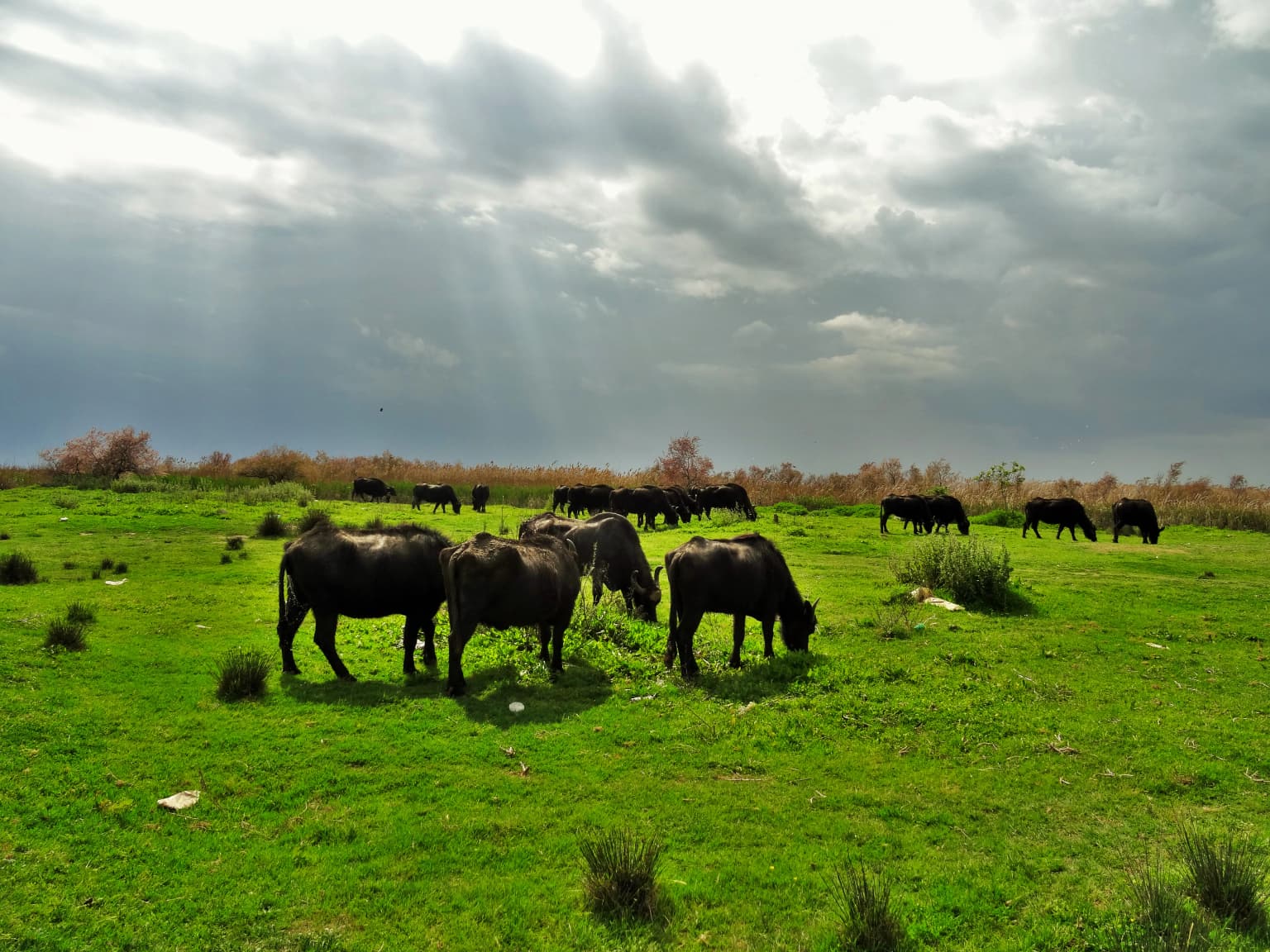
However, the park faces significant conservation challenges. The location within one of Greece's most densely populated regions creates ongoing pressure from urban development and agricultural expansion. The productive delta soils have traditionally been converted to rice paddies—now occupying approximately one-third of the park's area—though this use predates formal protection and continues under the sustainable use framework appropriate for IUCN Category VI. Water quality in the rivers and coastal zone faces threats from agricultural runoff and the expanding mussel cultivation industry, with recent studies detecting cyanotoxins in some areas. The water buffalo population, once widespread across Greek wetlands, has declined dramatically, with most of the national herd now concentrated in this area, requiring active management to prevent genetic erosion of this traditional breed. The critically endangered noble pen shell has suffered catastrophic population declines across the Mediterranean, making the Axios Delta populations increasingly important for species survival.

Axios Delta National Park cultural meaning and human context

The Axios Delta has been shaped by millennia of human activity, with the fertile delta soils and abundant fish and wildlife supporting agricultural communities since antiquity. The rivers that form the delta carry historical names reflecting the region's complex past—the Axios was known as the Vardar in antiquity and remains important in the cultures of North Macedonia and Serbia, while the Haliacmon (Aliakmonas) was a significant river in the ancient Macedonian kingdom. The area's traditional occupations—fishing, rice cultivation, salt production, and water buffalo husbandry—reflect the natural resources the delta provides and have become embedded in the cultural identity of the local communities.

Water buffalo farming in the delta exemplifies this cultural connection, with Greek buffaloes dating back approximately 2,500 years to the period when Xerxes used them to supply his army during the Greco-Persian Wars. These animals remain in the delta today, with one of Greece's largest herds concentrated near the Gallikos river mouth. The traditional mussel cultivation industry produces 30,000 tons annually—80-90% of Greece's total production—supporting local livelihoods and contributing significantly to the national economy. Rice cultivation occupies extensive areas within the park, with the flat, easily flooded delta soils being ideal for paddy rice production. The salt evaporation ponds at Alyki Kitrous represent another traditional activity, producing 28,000 tons annually and constituting Greece's second-largest salt works.

Fishing villages such as Chalastra cluster along the delta margins, their traditional architecture reflecting the maritime and agricultural character of the region. These communities have adapted their practices over generations to work with the seasonal rhythms of the delta—timing fishing activities with fish migrations, adjusting rice cultivation to water availability, and managing water buffalo herds in response to changing wetland conditions. The coexistence of these traditional uses with modern conservation objectives defines the character of the park as a living landscape where cultural and natural values interweave rather than exist in opposition.

Water buffalo with large horns facing the camera, standing in a field of tall brown reeds and green vegetation under a clear sky
Water buffalo standing in tall reeds within Axios Delta National Park

Top sights and standout views in Axios Delta National Park

The Axios Delta stands as one of the Mediterranean region's most significant wetland complexes, where the confluence of four major river systems creates exceptional biodiversity along Europe's principal bird migration corridor. The park's 299 recorded bird species—representing two-thirds of Greece's avifauna—include globally important populations of Dalmatian pelican, greater flamingo, and pygmy cormorant that nest and feed in the extensive reedbeds and shallow lagoons. The coastal sand dunes between Alyki Kitrous lagoon and the Aegean Sea hold Europe's largest and the world's most densely populated colony of Hermann's tortoises, a vulnerable species found in remarkable concentrations in this specialized habitat.

The park's cultural landscape reflects centuries of human interaction with the delta environment, where rice paddies, mussel farms, salt works, and water buffalo herds continue operating alongside conservation objectives. The Axios horse, a unique feral breed descended from abandoned farm animals in the 1960s, represents an unusual example of domestic animals becoming integrated into a wild ecosystem. The proximity to Thessaloniki—just 10 kilometers away—makes this an accessible wilderness area for urban populations, while the multiple international designations (Ramsar site, Important Bird Area, Natura 2000) ensure ongoing attention to conservation challenges including water quality, habitat management, and the preservation of traditional land uses that define the delta's character.

Flamingos and cranes wading in shallow water, with tall reeds and industrial port cranes visible in the distance
Flamingos and cranes wading in the Axios Delta wetlands with Thessaloniki cityscape in the background

Best time to visit Axios Delta National Park

The Axios Delta offers excellent birdwatching opportunities throughout the year, though the optimal timing depends on specific interests. Spring migration (March through May) brings enormous numbers of passage birds through the delta, with the reedbeds and lagoons hosting dramatic concentrations of waders, terns, and waterfowl as they move between wintering and breeding grounds. This period offers the best chance to observe the full diversity of species, as both resident breeders and migratory visitors are present simultaneously. The breeding season (April through July) sees the colonial nesting species—flamingos, pelicans, herons—at their most active, with chick-rearing providing excellent viewing opportunities.

Autumn (September through November) offers another migration spectacle as birds return south, often in even larger numbers than in spring. The winter months bring different species as northern European birds join the resident populations, with large flocks of greater flamingos remaining year-round and providing reliable viewing. The climate is cold semi-arid, with hot dry summers and cold wet winters, meaning that spring and autumn visits avoid both the intense summer heat and the potentially wet winter conditions. Summer temperatures can be high, though the wetland areas remain productive, while winter brings the majority of annual rainfall, with most precipitation occurring in autumn. Snow is infrequent and waters rarely freeze, ensuring the delta remains accessible and active even in the cooler months.

Park location guide

Geography guide, regional context, and park location map for Axios Delta National Park

Axios Delta National Park park geography, regions, and map view in Greece
Understand where Axios Delta National Park sits in Greece through a broader geographic reading of the surrounding landscape, nearby location context, and its mapped position within the national park landscape.

How Axios Delta National Park fits into Greece

Greece, officially the Hellenic Republic, is a country in Southeast Europe occupying the southern Balkans. It borders Albania, North Macedonia, Bulgaria, and Turkey, with coastlines on the Aegean, Ionian, and Mediterranean seas. The country has over 10 million people and is renowned for its ancient Greek heritage, philosophy, democracy, and the Olympic Games.

Wider geography shaping Axios Delta National Park in Greece

Greece occupies the southern tip of the Balkan peninsula in Southeast Europe. It shares land borders with Albania to the northwest, North Macedonia and Bulgaria to the north, and Turkey to the east. The Aegean Sea lies to the east of the mainland, the Ionian Sea to the west, and the Sea of Crete and Mediterranean Sea to the south. The country spans thousands of islands across nine traditional geographic regions and has the longest coastline in the Mediterranean basin.

Map view of Axios Delta National Park

Use this park location map to pinpoint Axios Delta National Park in Greece, understand its exact geographic position, and read its mapped placement within the surrounding landscape more clearly.

Pigeon | © OpenStreetMap contributors

Location context for Axios Delta National Park

Central Macedonia

Explore the diverse wetland ecosystems, intricate river deltas, and crucial bird habitats through detailed protected area imagery.

Axios Delta National Park Photos: Visualizing Greece's Vital Wetland Landscapes and Wildlife Habitats
Browse comprehensive imagery of Axios Delta National Park, visually understanding its expansive coastal wetlands, river deltas, and distinct brackish lagoons. The photography offers clear insight into the park's diverse habitats, supporting its critical role as a bird migration corridor and a unique Mediterranean protected area.

Birds flying above calm water with reflections in the wetland

A row of wooden houses on stilts along a calm waterway with boats docked along a wooden pier

Water buffalos grazing in a grassy field with sunlight rays filtering through clouds

Satellite image of Axios Delta National Park in Greece with river deltas, coastal wetlands, agricultural fields, and urban areas

Person walking on red gravel boardwalk surrounded by water, with concrete planters and vegetation along the sides

Blue and white fishing boat docked next to a wooden stilt house on water with open sea in background

Water buffalo with large horns facing the camera, standing in a field of tall brown reeds and green vegetation under a clear sky

Flamingos and cranes wading in shallow water, with tall reeds and industrial port cranes visible in the distance

Five flamingos standing in shallow water with reflections visible in calm water

Landscape of Axios Delta National Park featuring marshes, water bodies, reeds, and grasses under a clear sky.

Aerial view of a wetland with a flock of white birds swimming in shallow water, surrounded by marshy land and water channels

Close-up view of pink and white wildflowers among green foliage in Axios Delta National Park

Two wild horses, one black and one white with spots, standing in a green meadow with trees in the background

Three pink flamingos standing in blue water with long legs visible

A flock of flamingos with pink bodies and black wing feathers flying over a body of water.

Red gravel trail running through wetland areas with water on both sides under clear blue sky

Park atlas

Compare protected areas across Central Macedonia, tracing coastal wetlands and diverse conservation landscapes.

Explore Other National Parks and Protected Areas Near Axios Delta National Park
Continue your exploration from Axios Delta National Park by browsing other national parks and protected areas within Central Macedonia's diverse geography. Compare nearby wetlands, coastal deltas, and significant conservation landscapes, gaining richer context for the region's unique natural heritage.
Watercolor painting of a landscape with green trees, rolling hills, and distant mountains under a light sky
National parkMunicipality of Bitola

Pelister National Park: North Macedonia's Oldest National Park and Alpine Protected Landscape

Explore unique glacial features and endemic forests within Municipality of Bitola.

Pelister National Park, a pioneering protected area in North Macedonia, offers a rich tapestry of alpine geography and unique geological formations. This page provides detailed information on the park's landscape, including its dramatic mountain massif within Municipality of Bitola, the rare Macedonian pine forests, the striking 'stone rivers' formed by ancient glacial processes, and the serene Pelister Eyes glacial lakes. Discover the park's mapped boundaries and its significance as a conservation heritage site within the Balkan Peninsula.

Area
171.5 km²
Established
1948
IUCN
II
Visitors
30K annual
Watercolor illustration of green mountains and a lake with trees
National parkBlagoevgrad Province

Pirin National Park: Protected Area and Regional Geographic Context in Bulgaria

Explore Pirin National Park's mapped boundaries and landscape.

Pirin National Park serves as a vital national park entity within the atlas of Blagoevgrad Province, Bulgaria. This page details its protected landscape, offering a structured view of its geographic setting and mapped terrain. Users can investigate the park's specific identity and its relation to the surrounding regional geography, providing essential context for understanding protected areas and natural landscapes within a comprehensive map-driven framework.

Area
403.56 km²
Established
1962
IUCN
II
Relief
Mountain
Watercolor illustration of a mountainous landscape with a river, forests, and distant hills
National park

Pindus National Park: A Protected Greek Mountain Wilderness with Ancient Forests

Explore its rugged terrain, biodiversity, and alpine landscape.

MoriAtlas presents Pindus National Park, a significant protected area in Greece known for its dramatic mountainous terrain, deep valleys, and ancient old-growth forests. This page details its geographic context, featuring rugged highland landscapes, serpentine soils, and vital habitats for species like the Eurasian brown bear. Understand its place within the Pindus mountain range and its importance as a mapped wilderness area for conservation.

Area
69.27 km²
Established
1966
Relief
Mountain
Climate
Temperate
Watercolor painting of a river flowing through a valley with mountains and greenery
National parkKorçë County

Prespa National Park: Protected Landscape and High-Altitude Lakes in Korçë County, Albania

Explore the geography and mapped boundaries of this vital national park.

Prespa National Park, located in Korçë County, Albania, is a protected area characterized by its significant high-altitude tectonic lakes, dramatic mountain landscapes, and vital wetland habitats. This entry provides a structured atlas-style overview of the park's geographic identity, its protected landscape features, and its ecological importance, serving as a key point of reference for understanding this unique Balkan region.

Area
276.13 km²
Established
1999
IUCN
II
National park

Vikos-Aoös National Park: Deepest Gorge and Protected Mountain Landscape Atlas

Discover protected area boundaries and regional geography in Epirus.

Vikos-Aoös National Park in Greece's Pindus mountains is a premier destination for exploring dramatic natural geography. Best known for the Vikos Gorge, considered the world's deepest canyon relative to its width, the park also features towering alpine peaks like Mount Tymphe, glacial lakes such as Drakolimni, and rich botanical diversity. As a UNESCO Geopark and part of the Natura 2000 network, it safeguards critical habitats, including significant brown bear populations. This park offers a profound look into protected landscapes, offering detailed geographic context and mapped terrain for atlas-based discovery.

Area
126 km²
Established
1973
IUCN
II
Visitors
100K annual
Watercolor illustration of a coastal landscape with hills, trees, and a body of water
Marine protected area

National Marine Park of Alonnisos Northern Sporades: Protected Marine Landscape and Aegean Geography

Explore Greece's largest marine protected area and its vital ecosystems.

Investigate the National Marine Park of Alonnisos Northern Sporades, an extensive marine protected area situated in the northern Aegean Sea. This protected landscape is internationally significant for its role in conserving the Mediterranean monk seal and for its healthy Posidonia oceanica seagrass meadows. Understanding this park's geographic scope and its protected marine terrain offers crucial insights into Mediterranean island ecosystems and conservation efforts within the region.

Area
2,260 km²
Established
1992
IUCN
II
Relief
Mixed relief
Watercolor illustration showing mountains, river, and forested area
National park

Rodopi Mountain Range National Park: Greece's Largest Protected Forest Landscape Explorer

Mapped boundaries, old-growth ecosystems, and Balkan geography.

Rodopi Mountain Range National Park is a critical protected forest area in Greece, safeguarding one of Europe's last primeval forests, the Frakto Virgin Forest. As the nation's largest woodland conservation site, it showcases remarkable biodiversity and complex mountain terrain, from low-lying forests to subalpine meadows. This page provides detailed mapping context and geographic specifics for understanding this unique protected landscape and its ecological significance within the Rhodope Mountains.

Area
1,731.5 km²
Established
2009
IUCN
VI
Relief
Mountain
Watercolor painting of a landscape with green fields, scattered trees, and rolling hills under a light sky
National parkGjirokastër County

Fir of Hotovë-Dangëlli National Park: Ancient Forests & Mountain Wilderness Atlas

Explore a premier protected landscape in Gjirokastër County, Albania.

Fir of Hotovë-Dangëlli National Park stands as a monumental protected area, celebrated for its exceptional old-growth Hotova Fir forests, which are a rare Mediterranean plant relic. This national park in Gjirokastër County offers a detailed look at a vast mountainous terrain, featuring dramatic canyons like Lengarica Canyon, and serving as a critical habitat for diverse wildlife. MoriAtlas provides structured geographic context for this significant landscape, highlighting its mapped boundaries and role as a key component of regional protected area networks.

Area
360.038 km²
Established
2008
IUCN
II
Relief
Mountain

Common questions about visiting, size, designation, and location context for Axios Delta National Park

Axios Delta National Park FAQs for park facts, access, geography, and protected area context
Find quick answers about Axios Delta National Park, including protected-area facts, park geography, trail and visitor context, and how the park fits into its surrounding country and regional landscape.
MoriAtlas Explorer

Continue Your Protected Areas Search Across the Global Atlas

Deepen your exploration by continuing the structured search for national parks and protected areas worldwide. Utilize the comprehensive filtering capabilities to compare different conservation landscapes and refine your understanding of global park geography. Discover more about the distribution and characteristics of protected natural areas.

Global natural geography