Mori Atlas logo
Protected areaAncient Troya National Park

Discover the geographic setting and historical terrain of one of Turkey's most significant protected areas.

Ancient Troya National Park: Mapped Protected Area and Archaeological Landscape in Turkey

Ancient Troya National Park represents a protected area centered around the legendary UNESCO World Heritage site of Troy. Located in northwestern Turkey, this park preserves the extensive archaeological remains and the surrounding landscape that shaped its storied past. Explore its strategic hilltop position, commanding views across the coastal plain, and understand how its gentle rolling terrain and Mediterranean vegetation contribute to the context of this profound historical and cultural discovery.

Archaeological siteUNESCO World HeritageBronze AgeGreek mythologyMediterraneanHistorical site
Colorful illustration of a waterfall flowing through a mountainous valley with pine trees and winding river

Ancient Troya National Park

Protected area

Park overview

Structured park overview, official facts, and landscape profile for Ancient Troya National Park

Ancient Troya National Park park facts, protected area profile, and essential visitor context
Review the core facts for Ancient Troya National Park, including designation, size, terrain, visitor scale, habitats, and operating context in one park-focused overview.

About Ancient Troya National Park

Ancient Troya National Park protects one of the world's most significant archaeological sites, representing a continuous sequence of civilization spanning nearly 3,500 years. The site sits on a limestone hill overlooking the coastal plain near the Dardanelles, a strategically important location that controlled maritime traffic between the Aegean Sea and the Sea of Marmara. The archaeological remains demonstrate sophisticated urban planning, defensive architecture, and cultural connections across the ancient Mediterranean world. The site's identification with the Troy of legend, while complex from a scholarly perspective, has contributed to its extraordinary cultural significance and international recognition.

Quick facts and research context for Ancient Troya National Park

Ancient Troya National Park is situated in the Çanakkale Province of northwestern Turkey, on the Asian side of the Dardanelles strait. The site represents one of the most extensively excavated and studied Bronze Age settlements in the eastern Mediterranean, with layers of occupation spanning from the Early Bronze Age through the Roman period. The protected area encompasses the visible archaeological remains including city walls, gates, theater, and various residential and religious structures.

Park context

Deeper park guide and search-rich context for Ancient Troya National Park

Ancient Troya National Park history, landscape, wildlife, and travel context
Explore Ancient Troya National Park through its history, landscape character, ecosystems, wildlife, conservation priorities, cultural context, and seasonal travel timing in a structured park guide built for atlas discovery and search intent.

Why Ancient Troya National Park stands out

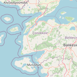
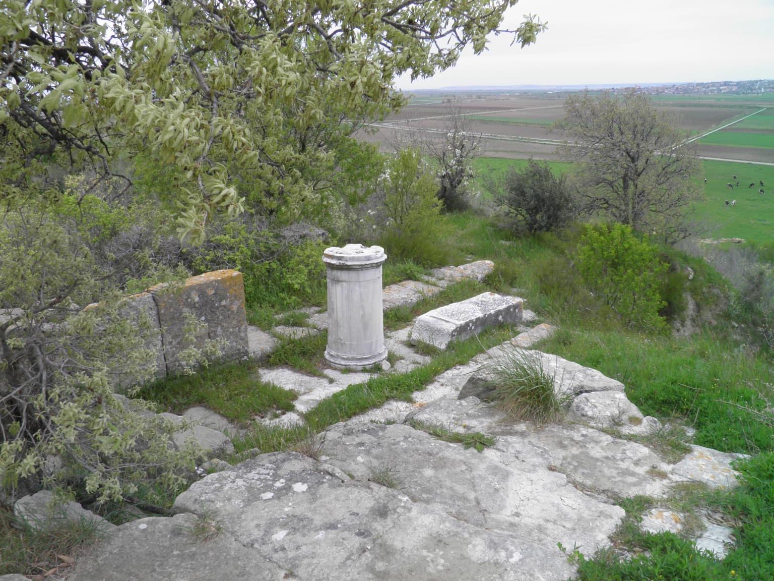
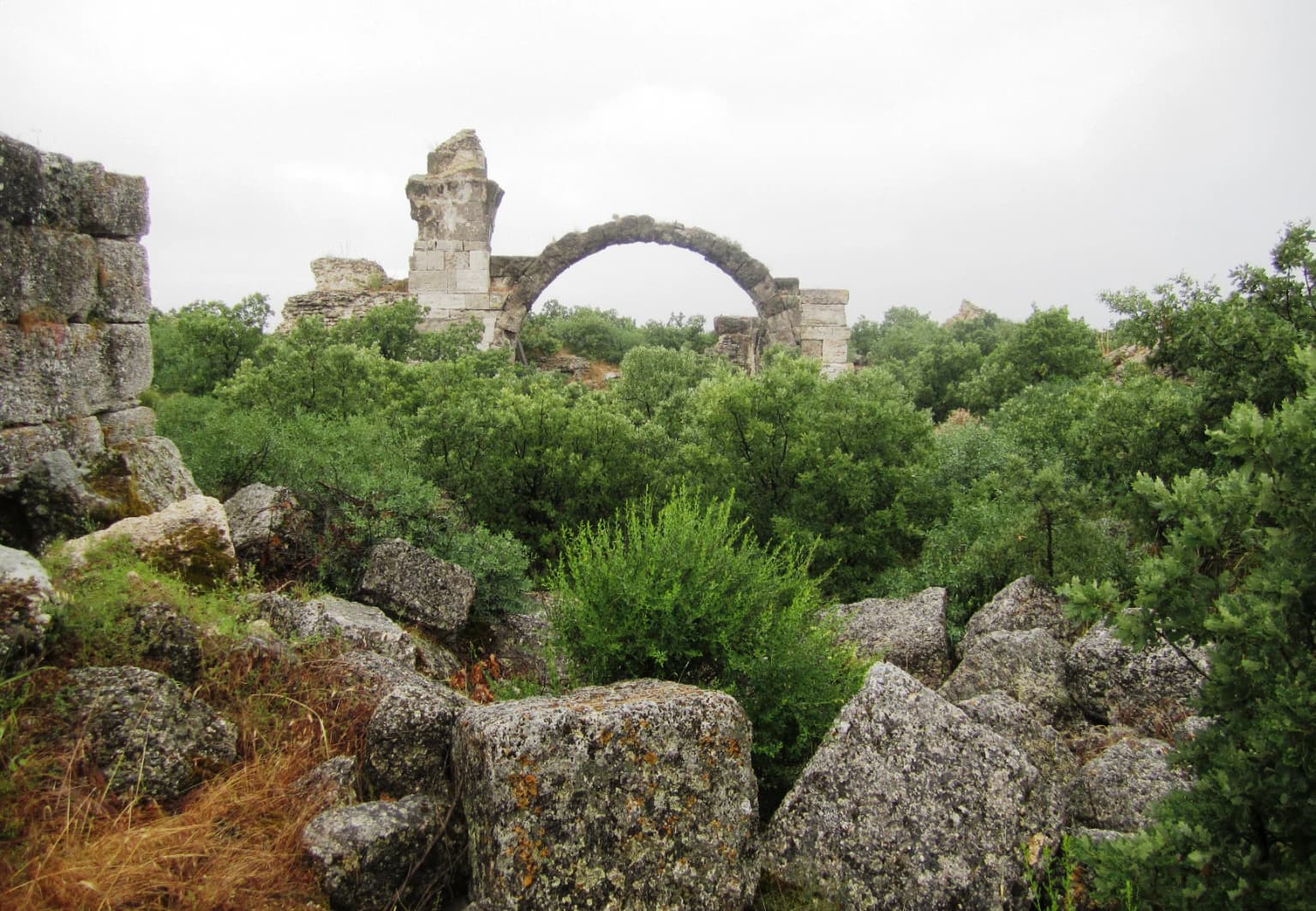
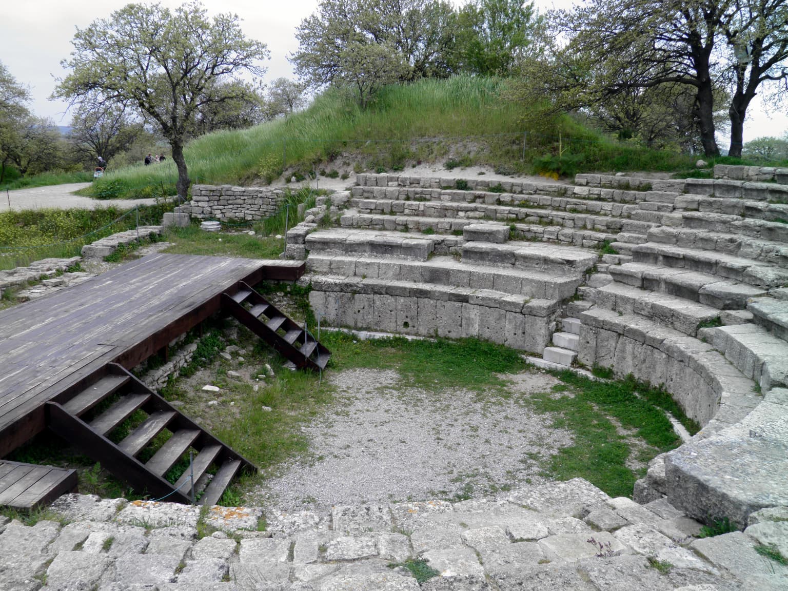
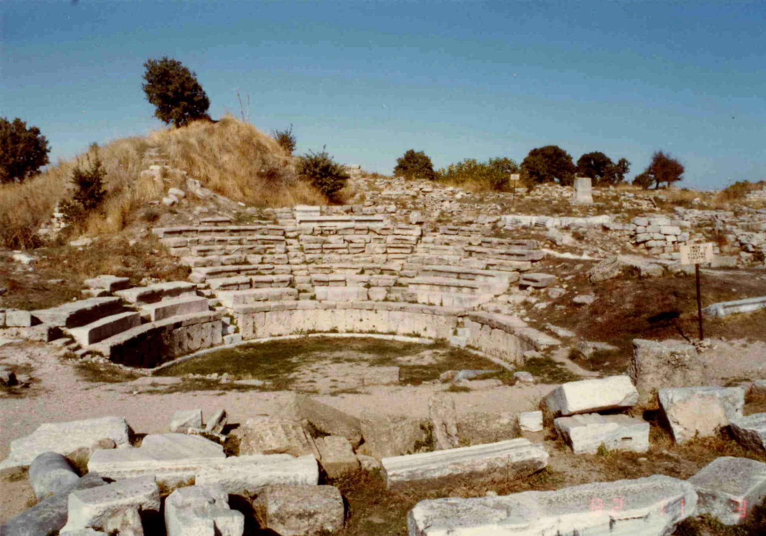
The park is best known for the legendary city of Troy, central to Greek mythology and Homer's epic poems. The archaeological site contains multiple layers of settlement dating from around 3000 BCE to 400 CE, with well-preserved elements including the famous walls and gates, the theater, the bouleverd street, and numerous house foundations. The site gained additional fame from the 19th-century excavations by Heinrich Schliemann and subsequent archaeological work that confirmed the location's historical authenticity.

Panoramic view of ancient stone walls from Troy's Level VI site, with visitors on pathways, trees, and clear blue sky
Panoramic view of ancient Trojan walls from Level VI, with visitors exploring pathways under clear blue sky

Ancient Troya National Park history and protected-area timeline

The history of Troy as a protected area begins with early archaeological exploration in the 19th century. Heinrich Schliemann's excavations beginning in 1871 revealed the site's extraordinary depth and complexity, discovering multiple fortified citadel layers. Subsequent excavations by various teams, including those of Carl Blegen in the 1930s and the University of Cincinnati's ongoing work, have progressively revealed the site's extent and significance. The area was designated as a national park to protect both the archaeological resources and the cultural landscape that contributes to understanding the ancient city's context.

Ancient Troya National Park landscape and geographic character

The park occupies a strategic hilltop position commanding views across the coastal plain toward the Dardanelles. The surrounding landscape is characterized by gentle rolling terrain with agricultural land and Mediterranean vegetation. The archaeological site itself sits on a defensible eminence with the remnants of massive fortification walls, towers, and gates visible across the excavated areas. The landscape retains elements of its historic setting, though modern agricultural activity and infrastructure are present in the surrounding region.

Stone ruins including a cylindrical column base and scattered stone fragments on a grassy hillside with trees and distant fields
Ancient stone ruins on a grassy hillside at Troy, Turkey

Ancient Troya National Park ecosystems, habitats, and plant life

While primarily an archaeological site, the park's setting includes typical Mediterranean vegetation and birdlife characteristic of the northwestern Turkish coastal region. The surrounding agricultural landscape supports various bird species and small wildlife. The ecological context is secondary to the site's archaeological significance but contributes to the overall visitor experience and environmental diversity of the protected area.

Stone arch ruins of Alexandria Troas with scattered boulders and dense vegetation under overcast sky
Ruins of Alexandria Troas with stone arch and surrounding greenery

Ancient Troya National Park wildlife and species highlights

The wildlife in the park and surrounding area includes typical Mediterranean bird species, small mammals common to the region, and occasionally larger mammals in the broader countryside. The area is not primarily known for wildlife viewing, and the significant biodiversity value lies in the archaeological and cultural resources rather than ecological systems.

Ancient stone ruins with wooden walkway and railings, surrounded by trees under a clear blue sky with scattered clouds.
Panoramic view of ancient stone ruins at Troy Ancient City under a clear blue sky.

Ancient Troya National Park conservation status and protection priorities

The national park designation provides legal protection for the archaeological remains and surrounding landscape. Conservation efforts focus on preserving the exposed structures, managing visitor access to minimize damage, and maintaining appropriate conditions for ongoing archaeological research. The site has been inscribed on the UNESCO World Heritage List, adding international protection frameworks and conservation standards.

Ancient Troya National Park cultural meaning and human context

Troy holds extraordinary significance in Western cultural tradition, being the setting for Homer's Iliad and the Trojan War cycle of myths. The legendary fall of Troy to the Greeks, involving the famous wooden horse, has shaped literature, art, and cultural understanding for millennia. The site's identification and excavation confirmed the historical kernel underlying the mythological narratives, bridging legendary and archaeological history.

Stone amphitheater with tiered seating, wooden platform with stairs, grassy area, and trees in the background
Ancient stone amphitheater structure with tiered seating and wooden platform in Troya National Park

Top sights and standout views in Ancient Troya National Park

The park's highlights include the iconic walls and gates of the citadel, the well-preserved Greek and Roman theater, the ancient bouleverd street with its colonnades, and the panoramic views across the Dardanelles region. The on-site museum provides context for the excavations and artifacts. The site's profound mythological significance, connecting to the earliest European literary traditions, remains the central cultural draw.

Stone amphitheater ruins with tiered seating, grassy center, and scattered stone blocks under clear sky
Ancient stone amphitheater ruins in Troya National Park, Turkey, with tiered seating and scattered stone blocks

Best time to visit Ancient Troya National Park

The best time to visit Troy is during spring and fall when temperatures are moderate and visitor numbers are lower than summer peaks. The archaeological site is most comfortable to explore during cooler months, and the surrounding landscape shows pleasant seasonal character. Summer months can be very hot, while winter may have limited access and facilities.

Park location guide

Geography guide, regional context, and park location map for Ancient Troya National Park

Ancient Troya National Park park geography, regions, and map view in Turkey
Understand where Ancient Troya National Park sits in Turkey through a broader geographic reading of the surrounding landscape, nearby location context, and its mapped position within the national park landscape.

How Ancient Troya National Park fits into Turkey

Turkey, officially the Republic of Türkiye, is a transcontinental country located mainly in Anatolia (West Asia) with a smaller portion in East Thrace (Southeast Europe). It borders the Black Sea to the north, several countries to the east and south, and the Aegean Sea and European countries to the west. The country has a population of over 86 million and operates as a secular, Muslim-majority presidential republic with Ankara as capital and Istanbul as its largest city.

Wider geography shaping Ancient Troya National Park in Turkey

Turkey is a transcontinental country with the majority of its territory (about 97%) located in Anatolia (West Asia) and a smaller portion called East Thrace in Southeast Europe. It borders the Black Sea to the north, Georgia, Armenia, Azerbaijan, and Iran to the east, Iraq and Syria to the south, and the Mediterranean Sea to the southwest. To the west, Turkey borders the Aegean Sea, Greece, and Bulgaria. The terrain includes mountains, plateaus, and coastal plains, with the Taurus Mountains running along the southern coast.

Map view of Ancient Troya National Park

Use this park location map to pinpoint Ancient Troya National Park in Turkey, understand its exact geographic position, and read its mapped placement within the surrounding landscape more clearly.

Pigeon | © OpenStreetMap contributors

Visual Atlas of Troy's Historic Terrain, Protected Archaeological Areas, and Surrounding Mediterranean Environment

Ancient Troya National Park Photos: Explore Legendary Landscapes and Archaeological Scenery
Browse a comprehensive visual atlas of Ancient Troya National Park, showcasing its iconic archaeological ruins, defensive walls, and the unique Mediterranean landscape that defines this UNESCO World Heritage Site. Examining park imagery helps visitors understand the ancient city's strategic hilltop setting, the layered historical context, and the distinctive natural character of the protected area.

Panoramic view of ancient stone walls from Troy's Level VI site, with visitors on pathways, trees, and clear blue sky

Ancient stone walls of Troya National Park with stone pathway, dry grass, and scattered trees under clear blue sky

Stone ruins including a cylindrical column base and scattered stone fragments on a grassy hillside with trees and distant fields

Stone arch ruins of Alexandria Troas with scattered boulders and dense vegetation under overcast sky

Ancient stone ruins with wooden walkway and railings, surrounded by trees under a clear blue sky with scattered clouds.

Stone steps and wooden platform of the Hadrianic Odeon with surrounding greenery and trees

Stone amphitheater with tiered seating, wooden platform with stairs, grassy area, and trees in the background

Stone amphitheater ruins with tiered seating, grassy center, and scattered stone blocks under clear sky

Stone pathway with ancient rampart walls on both sides under clear blue sky

Museum display case containing ancient pottery vessels, stone tools, and small sculptures

Stone ruins with a central pillar and overgrown grass, part of the archaeological site of Troy

Stone walls forming an ancient pathway with a gravel path between them, trees in the background

Park atlas

Map the surrounding protected landscapes and compare their unique geographies across Turkey

Explore Other National Parks and Protected Areas Near Ancient Troya National Park
Continue your exploration from Ancient Troya National Park by browsing other national parks and protected areas located across Turkey's diverse geography. Compare their unique characteristics, trace their regional spread, and understand the varied conservation landscapes that span from the Mediterranean coast to inland Anatolian terrains.
Watercolor painting showing green and pink mountain ranges with a body of water in the middle
National parkTurkey

Kazdağı National Park: Explore Turkey's Protected Mountainous Terrain and Forest Ecosystem

Mapped geography and protected landscape context within Turkey's Aegean region.

Kazdağı National Park is a significant protected area in Turkey, renowned for its dramatic mountain landscape encompassing Mount Ida. This park safeguards a critical subalpine forest ecosystem, characterized by diverse tree species that transition into rocky summits and alpine meadows. Understanding Kazdağı National Park's mapped boundaries provides essential insight into the regional geography, watershed protection, and the unique natural terrain found in western Turkey's Mediterranean mountain ranges, offering a solid foundation for geographic discovery.

IUCN
II
Scope
Terrestrial
National parkTurkey

Lake Gala National Park: A Key Protected Wetland Landscape in Turkey's Maritsa Delta

Discover its bird habitats and mapped geographic context.

Lake Gala National Park is a nationally significant protected area, designated in 2005 to conserve the unique wetland ecosystem of the Maritsa Delta. Encompassing the shallow lakes Pamuklu and Küçük Gala, this park spans approximately 6,090 hectares of diverse wetland and forest habitats. It is internationally recognized as a Ramsar site and serves as a critical sanctuary for over 160 bird species, making it a premier birdwatching destination in Turkey and an important locus for understanding protected landscapes within a regional geographic framework.

Area
60.9 km²
Established
2005
IUCN
II
Relief
Lowland
Watercolor illustration of green fields, clusters of trees, distant mountains, and a light yellow sky
National parkEastern Macedonia and Thrace

Dadia-Lefkimi-Soufli Forest National Park: Protected Landscape Atlas and Raptor Habitat

Mapped terrain and protected area context in Eastern Macedonia and Thrace.

This canonical entry for Dadia-Lefkimi-Soufli Forest National Park provides a structured atlas view of its protected landscape. Understand the park's geographic setting within Eastern Macedonia and Thrace, its mapped boundaries, and its significance as a critical sanctuary for raptors across Europe. Explore the diverse natural terrain that defines this protected area and its ecological importance.

Area
428 km²
Established
2006
IUCN
VI
Visitors
50K annual
Watercolor illustration of a river, green fields, trees, and distant hills
National parkBalıkesir Province

Kuşcenneti National Park: Mapping Turkey's Premier Bird Sanctuary and Wetland Ecosystem

Explore the protected boundaries and avian geography of this key national park.

Kuşcenneti National Park stands as Turkey's foundational protected area for bird conservation, celebrated for its critical role as an avian migration crossroads and nesting ground. Situated in Balıkesir Province, this national park encompasses a diverse wetland ecosystem including shallow lakes, flooded willow forests, and extensive marshlands. MoriAtlas provides a detailed geographic context for Kuşcenneti National Park, highlighting its mapped protected area, unique landscape features, and profound significance for regional avian biodiversity.

Area
240.47 km²
Established
1959
IUCN
II
Visitors
2.5M annual
Watercolor illustration of layered mountain ranges with green, yellow, and pink hues
National parkTurkey

Mount Spil National Park: Turkey's National Park and Protected Landscape Atlas Entry

Explore its mapped boundaries and regional geographic context.

Mount Spil National Park is presented here as a key protected area within Turkey's atlas of natural landscapes. This detail page focuses on its identity as a national park, providing a structured overview of its mapped boundaries and geographic setting. Understand its landscape context and its significance within Turkey's network of protected lands for detailed atlas exploration and geographic discovery.

IUCN
II
Scope
Mixed
Water
Minor water
Watercolor illustration of a coastal landscape with hills, trees, and a body of water
Marine protected area

National Marine Park of Alonnisos Northern Sporades: Protected Marine Landscape and Aegean Geography

Explore Greece's largest marine protected area and its vital ecosystems.

Investigate the National Marine Park of Alonnisos Northern Sporades, an extensive marine protected area situated in the northern Aegean Sea. This protected landscape is internationally significant for its role in conserving the Mediterranean monk seal and for its healthy Posidonia oceanica seagrass meadows. Understanding this park's geographic scope and its protected marine terrain offers crucial insights into Mediterranean island ecosystems and conservation efforts within the region.

Area
2,260 km²
Established
1992
IUCN
II
Relief
Mixed relief
Watercolor illustration showing mountains, river, and forested area
National park

Rodopi Mountain Range National Park: Greece's Largest Protected Forest Landscape Explorer

Mapped boundaries, old-growth ecosystems, and Balkan geography.

Rodopi Mountain Range National Park is a critical protected forest area in Greece, safeguarding one of Europe's last primeval forests, the Frakto Virgin Forest. As the nation's largest woodland conservation site, it showcases remarkable biodiversity and complex mountain terrain, from low-lying forests to subalpine meadows. This page provides detailed mapping context and geographic specifics for understanding this unique protected landscape and its ecological significance within the Rhodope Mountains.

Area
1,731.5 km²
Established
2009
IUCN
VI
Relief
Mountain
Watercolor landscape showing mountains, trees, and a river
National parkTurkey

Uludağ National Park: Turkey's Oldest National Park's Alpine Landscape and Geography

Mapped protected area in Turkey's Marmara region.

Delve into the protected landscape of Uludağ National Park, Turkey's first national park, renowned for its distinctive alpine environment and dramatic mountain terrain. This page offers a detailed atlas view of the park's geography, mapped boundaries, and unique ecosystems, providing essential context for understanding this significant protected area within Turkey's natural heritage.

Established
1961
IUCN
II
Relief
Mountain
Climate
Temperate

Common questions about visiting, size, designation, and location context for Ancient Troya National Park

Ancient Troya National Park FAQs for park facts, access, geography, and protected area context
Find quick answers about Ancient Troya National Park, including protected-area facts, park geography, trail and visitor context, and how the park fits into its surrounding country and regional landscape.
MoriAtlas Explorer

Continue Your Protected Areas Search Across the Global Atlas

Deepen your exploration by continuing the structured search for national parks and protected areas worldwide. Utilize the comprehensive filtering capabilities to compare different conservation landscapes and refine your understanding of global park geography. Discover more about the distribution and characteristics of protected natural areas.

Global natural geography