Mori Atlas logo
National parkMount Spil National Park

Mapping the boundaries and geographic context of a key protected area in Turkey.

Mount Spil National Park: National Park and Protected Landscape Identity in Turkey

Mount Spil National Park represents a significant protected area within Turkey's diverse geography. This page provides an atlas-driven overview, focusing on the park's mapped boundaries and its role as a national park. Explore its regional landscape context and understand its place within the broader protected lands of Turkey for detailed map-based discovery.

TurkeyProtected AreaNational ParkMountain LandscapeWestern Anatolia
Illustration of a mountain landscape featuring a large rock formation, winding river, trees, and a bright sun in a partly cloudy sky

Mount Spil National Park

National park

Park overview

Structured park overview, official facts, and landscape profile for Mount Spil National Park

Mount Spil National Park park facts, protected area profile, and essential visitor context
Review the core facts for Mount Spil National Park, including designation, size, terrain, visitor scale, habitats, and operating context in one park-focused overview.
Park location guide

Geography guide, regional context, and park location map for Mount Spil National Park

Mount Spil National Park park geography, regions, and map view in Turkey
Understand where Mount Spil National Park sits in Turkey through a broader geographic reading of the surrounding landscape, nearby location context, and its mapped position within the national park landscape.

How Mount Spil National Park fits into Turkey

Turkey, officially the Republic of Türkiye, is a transcontinental country located mainly in Anatolia (West Asia) with a smaller portion in East Thrace (Southeast Europe). It borders the Black Sea to the north, several countries to the east and south, and the Aegean Sea and European countries to the west. The country has a population of over 86 million and operates as a secular, Muslim-majority presidential republic with Ankara as capital and Istanbul as its largest city.

Wider geography shaping Mount Spil National Park in Turkey

Turkey is a transcontinental country with the majority of its territory (about 97%) located in Anatolia (West Asia) and a smaller portion called East Thrace in Southeast Europe. It borders the Black Sea to the north, Georgia, Armenia, Azerbaijan, and Iran to the east, Iraq and Syria to the south, and the Mediterranean Sea to the southwest. To the west, Turkey borders the Aegean Sea, Greece, and Bulgaria. The terrain includes mountains, plateaus, and coastal plains, with the Taurus Mountains running along the southern coast.

Map view of Mount Spil National Park

Use this park location map to pinpoint Mount Spil National Park in Turkey, understand its exact geographic position, and read its mapped placement within the surrounding landscape more clearly.

Pigeon | © OpenStreetMap contributors

Dive into detailed photography showcasing the unique mountain landscape, diverse habitats, and protected-area character of this Western Anatolian gem.

Visual Guide to Mount Spil National Park: Explore Landscapes and Scenery
Explore the natural beauty of Mount Spil National Park through a comprehensive collection of images that reveal its unique mountain landscapes, varied terrain, and distinct ecological habitats. This visual resource offers an immersive perspective on the park's protected environment, aiding in a deeper understanding of its conservation value and regional geographic identity.

Large rock formation on a grassy hillside under a clear blue sky, with buildings visible in the distance

Panoramic landscape showing Mount Sipylus with a town and trees in the foreground under a clear sky

Black and white photograph of an ancient stone structure with a mountainous landscape in the background

Several brown horses standing in a grassy field with scattered trees and a tall metal tower

Park atlas

Browse a Geographic Atlas of Protected Landscapes Surrounding Mount Spil National Park in Western Anatolia, Turkey

Explore Nearby National Parks and Protected Areas Around Mount Spil National Park
Explore a curated selection of national parks and protected areas situated in the geographic vicinity of Mount Spil National Park, tracing diverse mountain landscapes across Western Anatolia. Gain valuable geographic context by comparing the unique conservation efforts, varied terrain, and protected-area characteristics of these sites with Mount Spil National Park.
National parkAydın Province

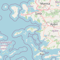
Dilek Peninsula-Büyük Menderes Delta National Park: Protected Landscape and Geographic Context

Aydın Province's unique national park with diverse ecosystems.

Investigate Dilek Peninsula-Büyük Menderes Delta National Park, a key protected area in Turkey's Aydın Province. This page provides detailed geographic context, highlighting the park's remarkable coexistence of mountainous terrain and essential wetland habitats. Understand the mapped boundaries and landscape characteristics that define this significant national park.

Area
275.98 km²
Established
1966
IUCN
II
Visitors
700K annual
Watercolor painting showing green and pink mountain ranges with a body of water in the middle
National parkTurkey

Kazdağı National Park: Explore Turkey's Protected Mountainous Terrain and Forest Ecosystem

Mapped geography and protected landscape context within Turkey's Aegean region.

Kazdağı National Park is a significant protected area in Turkey, renowned for its dramatic mountain landscape encompassing Mount Ida. This park safeguards a critical subalpine forest ecosystem, characterized by diverse tree species that transition into rocky summits and alpine meadows. Understanding Kazdağı National Park's mapped boundaries provides essential insight into the regional geography, watershed protection, and the unique natural terrain found in western Turkey's Mediterranean mountain ranges, offering a solid foundation for geographic discovery.

IUCN
II
Scope
Terrestrial
Watercolor illustration of a river, green fields, trees, and distant hills
National parkBalıkesir Province

Kuşcenneti National Park: Mapping Turkey's Premier Bird Sanctuary and Wetland Ecosystem

Explore the protected boundaries and avian geography of this key national park.

Kuşcenneti National Park stands as Turkey's foundational protected area for bird conservation, celebrated for its critical role as an avian migration crossroads and nesting ground. Situated in Balıkesir Province, this national park encompasses a diverse wetland ecosystem including shallow lakes, flooded willow forests, and extensive marshlands. MoriAtlas provides a detailed geographic context for Kuşcenneti National Park, highlighting its mapped protected area, unique landscape features, and profound significance for regional avian biodiversity.

Area
240.47 km²
Established
1959
IUCN
II
Visitors
2.5M annual
Watercolor illustration of a landscape featuring rolling hills, trees, and a small body of water
Protected areaTurkey

Ancient Troya National Park: A Mapped Protected Landscape with Deep Historical Significance

Explore the terrain and protected boundaries of this key Turkish heritage site.

Ancient Troya National Park offers a unique window into history, preserving the layers of the ancient city of Troy within its protected boundaries. Situated in Turkey, this park encompasses a significant archaeological site on a commanding hilltop, overlooking rolling Mediterranean terrain and coastal plains. Its landscape, characterized by fortified walls, gates, and the remnants of ancient structures, provides a rich context for understanding its mythological and historical importance. MoriAtlas provides detailed mapping and geographic context for this vital protected area, enhancing its atlas exploration value.

Established
1996
IUCN
II
Relief
Lowland
Climate
Mediterranean
Watercolor painting showing a lake with hills and forest in the background
National parkTurkey

Mount Honaz National Park: Turkey's National Park Protected Area Detail

Explore mapped protected landscape and regional geography.

Mount Honaz National Park is a designated national park in Turkey, offering valuable insights into the country's protected areas and natural landscapes. This page provides a focused view of its mapped boundaries and geographic significance, enabling detailed atlas-style exploration. Understand how this protected area contributes to the regional geography of Western Anatolia and complements the broader network of natural reserves within Turkey.

IUCN
II
Scope
Terrestrial
National parkMuğla Province

Marmaris National Park: Mediterranean Forest Protected Landscape and Ancient Heritage

Discover its geography, mapped boundaries, and unique flora.

Marmaris National Park in Muğla Province offers a deep dive into a protected Mediterranean forest ecosystem and Carian history. Explore its rugged terrain, dramatic coastlines where pine forests meet the sea, and discover ancient sites like the Amos amphitheatre. This park is a key area for understanding regional geography, mapped natural landscapes, and the unique botanical diversity of Turkey's southwestern coast, supporting detailed atlas exploration.

Area
333.5 km²
Established
1996
IUCN
II
Visitors
8.5M annual
Watercolor landscape showing mountains, trees, and a river
National parkTurkey

Uludağ National Park: Turkey's Oldest National Park's Alpine Landscape and Geography

Mapped protected area in Turkey's Marmara region.

Delve into the protected landscape of Uludağ National Park, Turkey's first national park, renowned for its distinctive alpine environment and dramatic mountain terrain. This page offers a detailed atlas view of the park's geography, mapped boundaries, and unique ecosystems, providing essential context for understanding this significant protected area within Turkey's natural heritage.

Established
1961
IUCN
II
Relief
Mountain
Climate
Temperate
Protected areaTurkey

Commander-in-Chief National Historic Park: Historic Battlefield Landscape in Turkey

Protected Area preserving pivotal geography and military history.

Commander-in-Chief National Historic Park is a designated protected area in Turkey, preserving the historic terrain of the decisive Battle of Dumlupınar. This site offers a unique glimpse into the geography and landscape that were instrumental in a key moment of the Turkish War of Independence. Explore the mapped context of this significant battlefield, understanding its role within the broader Anatolian geography and its importance as a preserved historic site.

Area
409.48 km²
Established
1981
IUCN
II
Relief
Mixed relief

Common questions about visiting, size, designation, and location context for Mount Spil National Park

Mount Spil National Park FAQs for park facts, access, geography, and protected area context
Find quick answers about Mount Spil National Park, including protected-area facts, park geography, trail and visitor context, and how the park fits into its surrounding country and regional landscape.
MoriAtlas Explorer

Continue Your Protected Areas Search Across the Global Atlas

Deepen your exploration by continuing the structured search for national parks and protected areas worldwide. Utilize the comprehensive filtering capabilities to compare different conservation landscapes and refine your understanding of global park geography. Discover more about the distribution and characteristics of protected natural areas.

Global natural geography