Mori Atlas logo
Protected areaCommander-in-Chief National Historic Park

Discover the mapped terrain and historic geography of this vital protected area in Turkey.

Commander-in-Chief National Historic Park: Preserving Turkey's Pivotal Battlefield Landscape

Commander-in-Chief National Historic Park represents a crucial protected area in Turkey, safeguarding the landscape where the decisive Battle of Dumlupınar unfolded. This historic site, spanning parts of Afyonkarahisar, Kütahya, and Uşak provinces, preserves the terrain that witnessed the culmination of the Turkish War of Independence. Explore the rolling hills and elevated plains that formed the strategic setting for a pivotal military campaign, offering a unique geographic context for understanding modern Turkish history through a dedicated atlas lens.

Historic SiteMilitary HistoryTurkish War of IndependenceBattlefield ParkNational ParkMemorial Sites

Commander-in-Chief National Historic Park

Protected area

Park overview

Structured park overview, official facts, and landscape profile for Commander-in-Chief National Historic Park

Commander-in-Chief National Historic Park park facts, protected area profile, and essential visitor context
Review the core facts for Commander-in-Chief National Historic Park, including designation, size, terrain, visitor scale, habitats, and operating context in one park-focused overview.

About Commander-in-Chief National Historic Park

Commander-in-Chief National Historic Park serves as Turkey's principal preserved historic site commemorating the Turkish War of Independence and the military campaign that ultimately secured Turkish national sovereignty. The park's territory spans the strategic terrain in western Central Anatolia where the final and most decisive battle of the Greco-Turkish War unfolded in August 1922. This military campaign, known as the Great Offensive (Büyük Taarruz), represented the culmination of years of resistance against occupying forces and marked the turning point that would reshape the political map of Anatolia and the surrounding region.

The park's establishment in 1981 reflected Turkey's commitment to preserving this defining chapter of national history for future generations. Beyond its military historical significance, the protected area encompasses the broader landscape where the Turkish forces coordinated their operations, including command positions, staging areas, and the actual ground over which the advancing armies moved toward victory. The park provides visitors with an understanding of both the strategic importance of the terrain and the human dimensions of the conflict through its memorials, monuments, and interpretive facilities.

Quick facts and research context for Commander-in-Chief National Historic Park

This national historic park occupies approximately 40,948 hectares at an average elevation of 1,000 meters in the Central Anatolia region of Turkey. It was established on November 8, 1981, specifically to protect and commemorate the battlefield of the Battle of Dumlupınar, the last major battle of the Turkish War of Independence. The park is divided into two main sections: the Kocatepe section southwest of Afyonkarahisar city, which includes the prominent Kocatepe Monument, and the Dumlupınar section spanning territories across Sinanpaşa, Altıntaş, Dumlupınar, and Banaz districts. Within the park boundaries lie several memorial cemeteries (şehitlik), monuments commemorating the battle, and a museum that preserves artifacts and records from this defining military campaign.

Park context

Deeper park guide and search-rich context for Commander-in-Chief National Historic Park

Commander-in-Chief National Historic Park history, landscape, wildlife, and travel context
Explore Commander-in-Chief National Historic Park through its history, landscape character, ecosystems, wildlife, conservation priorities, cultural context, and seasonal travel timing in a structured park guide built for atlas discovery and search intent.

Why Commander-in-Chief National Historic Park stands out

The park is best known as the preserved battlefield of the Battle of Dumlupınar, the climactic confrontation of the Turkish War of Independence. It was from this region that Mustafa Kemal Paşa issued his famous command to the advancing Turkish forces: "Ordular, ilk hedefiniz Akdeniz'dir, ileri!" (Armies, your first target is the Mediterranean, forward!). This decisive victory paved the way for the liberation of Anatolia and the subsequent declaration of the Turkish Republic. The park contains the Kocatepe Monument, which commemorates the commander-in-chief's headquarters, as well as memorial sites honoring the fallen soldiers of the independence war.

Wide landscape view of dry fields, scattered trees, a curved road, and distant mountains under a blue sky with scattered clouds
Vast open fields and winding road under a partly cloudy sky in Commander-in-Chief National Historic Park

Commander-in-Chief National Historic Park history and protected-area timeline

The Commander-in-Chief National Historic Park was established on November 8, 1981, specifically to protect and commemorate the historic battlefield of the Battle of Dumlupınar. This battle, fought on August 26–30, 1922, represented the final major engagement of the Turkish War of Independence, also known as the Turkish War of Liberation (Kurtuluş Savaşı) or the National Struggle (Millî Mücadele). The park's creation reflected the Turkish government's recognition of the site's importance in the nation's modern history and its commitment to preserving the physical environment associated with this pivotal moment.

The Battle of Dumlupınar was part of the larger Great Offensive launched by the Turkish forces under the command of Mustafa Kemal Paşa. Following years of occupation and resistance, the Turkish army launched this decisive campaign to reclaim occupied territories. The battle unfolded across the rolling terrain of western Anatolia, where Turkish forces achieved a decisive victory that forced the Greek army to retreat. The park preserves the physical landscape over which these historic events unfolded, including the positions from which Turkish commanders directed operations and the ground where the battles took place. The subsequent liberation of Izmir and other western Anatolian cities followed this victory, ultimately leading to the Treaty of Lausanne and international recognition of Turkish independence.

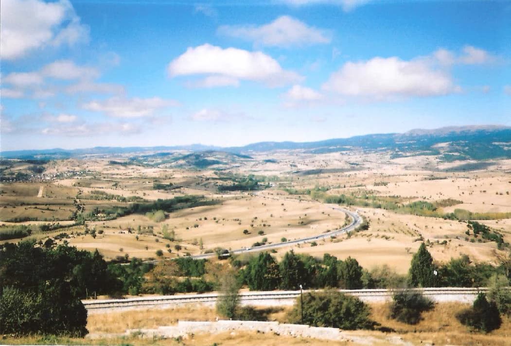
Commander-in-Chief National Historic Park landscape and geographic character

The park is situated in the Central Anatolia region of Turkey, occupying a landscape of rolling terrain and elevated plains at an average elevation of approximately 1,000 meters above sea level. The terrain consists of undulating hills, open valleys, and expansive plateaus that provided the strategic advantages exploited by Turkish commanders during the offensive. This landscape, typical of the Anatolian plateau, offered favorable conditions for large-scale military operations and movement of cavalry and infantry forces. The area falls within a continental climate zone characterized by hot, dry summers and cold winters, with steppe vegetation covering much of the surrounding region. The protected area encompasses portions of this historic terrain, preserving the physical setting that played such a crucial role in the decisive military campaign.

Commander-in-Chief National Historic Park ecosystems, habitats, and plant life

As a historic protected area rather than a nature reserve, the park's ecological character reflects the broader Central Anatolian steppe environment. The region features semi-arid grasslands and steppe vegetation adapted to the continental climate, with typical Anatolian flora including various grasses, wildflowers, and drought-resistant shrubs. The area supports wildlife populations common to the Central Anatolian plateau, including small mammals, reptiles, and bird species adapted to open grassland habitats. While the park's primary purpose is historical preservation rather than biodiversity conservation, the natural landscape remains largely intact and provides visitors with an appreciation of the terrain over which the historic events unfolded.

Commander-in-Chief National Historic Park wildlife and species highlights

The wildlife in the park and surrounding Central Anatolian region includes species typical of the Anatolian steppe and agricultural landscapes. Small mammals such as ground squirrels, mice, and rabbits inhabit the grasslands, while various reptile species including lizards and snakes are found in suitable habitats. The open terrain and surrounding agricultural areas support bird populations including larks, quail, and birds of prey such as hawks and kestrels. While the park is not specifically designated for wildlife conservation, the natural environment provides habitat for these native species that inhabit the Central Anatolian plateau.

Commander-in-Chief National Historic Park conservation status and protection priorities

The park's conservation significance lies in its preservation of a historically significant battlefield and surrounding landscape associated with Turkey's War of Independence. As a national historic park (Tarihi Milli Park), it represents Turkey's commitment to protecting sites of national importance that embody the nation's historical identity and struggle for sovereignty. The protected status ensures that the physical environment—battlefield terrain, memorial sites, and associated landmarks—remains preserved against development pressures and gradual alteration. The park's management balances historical preservation with public access, allowing visitors to engage with this significant chapter of Turkish history while ensuring the site's long-term protection.

Commander-in-Chief National Historic Park cultural meaning and human context

The park holds profound cultural significance in Turkey as the physical embodiment of the nation's independence and statehood. The Battle of Dumlupınar and the subsequent Great Offensive represent the defining moment in the Turkish War of Independence, when Turkish national forces under Mustafa Kemal's leadership achieved military victory that secured the nation's sovereignty. The park preserves not only the physical battlefield but also the memory of the sacrifice and struggle that culminated in the establishment of the Republic of Turkey in 1923. The monuments, memorial sites (şehitlik), and museum within the park serve as places of remembrance and education, allowing visitors to connect with this foundational period in Turkish national history. The famous command issued from this region—"Ordular, ilk hedefiniz Akdeniz'dir, ileri!"—remains one of the most iconic phrases in Turkish history and embodies the spirit of national liberation that the park commemorates.

Top sights and standout views in Commander-in-Chief National Historic Park

The park's primary significance rests on its status as the preserved battlefield of the decisive Battle of Dumlupınar, where Turkish forces secured their final major victory in the War of Independence. The Kocatepe Monument stands as the park's most prominent landmark, commemorating the commander-in-chief's headquarters and the strategic command center from which operations were directed. The various şehitlik (martyrs' cemeteries) throughout the park honor the fallen soldiers who gave their lives during the campaign. The on-site museum provides interpretive context through artifacts, documents, and displays that illuminate the historical events and their significance. The park's dual-section structure—with the Kocatepe area near Afyonkarahisar and the Dumlupınar section spanning multiple districts—allows visitors to explore different aspects of the battlefield and commemorative landscape.

Best time to visit Commander-in-Chief National Historic Park

The park can be visited throughout the year, though spring and autumn offer the most comfortable conditions for exploring the outdoor sites and monuments. Summer months can bring hot temperatures typical of Central Anatolia, while winters may bring cold conditions and possible snow. The park's outdoor nature makes it suitable for visits during cooler parts of the day in summer months. Visitors interested in history and military heritage will find the site most meaningful when they can leisurely explore the various monuments, memorial sites, and museum at a comfortable pace, allowing time to reflect on the historical significance of the landscape.

Park location guide

Geography guide, regional context, and park location map for Commander-in-Chief National Historic Park

Commander-in-Chief National Historic Park park geography, regions, and map view in Turkey
Understand where Commander-in-Chief National Historic Park sits in Turkey through a broader geographic reading of the surrounding landscape, nearby location context, and its mapped position within the national park landscape.

How Commander-in-Chief National Historic Park fits into Turkey

Turkey, officially the Republic of Türkiye, is a transcontinental country located mainly in Anatolia (West Asia) with a smaller portion in East Thrace (Southeast Europe). It borders the Black Sea to the north, several countries to the east and south, and the Aegean Sea and European countries to the west. The country has a population of over 86 million and operates as a secular, Muslim-majority presidential republic with Ankara as capital and Istanbul as its largest city.

Wider geography shaping Commander-in-Chief National Historic Park in Turkey

Turkey is a transcontinental country with the majority of its territory (about 97%) located in Anatolia (West Asia) and a smaller portion called East Thrace in Southeast Europe. It borders the Black Sea to the north, Georgia, Armenia, Azerbaijan, and Iran to the east, Iraq and Syria to the south, and the Mediterranean Sea to the southwest. To the west, Turkey borders the Aegean Sea, Greece, and Bulgaria. The terrain includes mountains, plateaus, and coastal plains, with the Taurus Mountains running along the southern coast.

Map view of Commander-in-Chief National Historic Park

Use this park location map to pinpoint Commander-in-Chief National Historic Park in Turkey, understand its exact geographic position, and read its mapped placement within the surrounding landscape more clearly.

Pigeon | © OpenStreetMap contributors

Location context for Commander-in-Chief National Historic Park

Afyonkarahisar ProvinceKütahya ProvinceUşak Province

Explore the preserved Central Anatolian terrain, strategic elevations, and significant monuments within this protected area through detailed images.

Commander-in-Chief National Historic Park Scenery: Visualizing Historic Battlefield Landscapes
Discover the unique visual identity of Commander-in-Chief National Historic Park by exploring its rich photographic gallery, capturing the historic battlefield's rolling terrain, steppe vegetation, and commemorative structures. These park images provide crucial insight into the protected landscape's strategic importance and its role in preserving a pivotal chapter of Turkish national history.

Wide landscape view of dry fields, scattered trees, a curved road, and distant mountains under a blue sky with scattered clouds

White memorial structure with a statue on a grassy hill, surrounded by pathways, visitors, and landscaped greenery under a blue sky

Park atlas

Compare protected landscapes and cultural heritage sites across the Central Anatolia region of Turkey.

Other National Parks Near Commander-in-Chief National Historic Park: Your Next Discovery
Explore other national parks and significant protected areas across Turkey, tracing diverse landscapes and conservation efforts geographically adjacent to Commander-in-Chief National Historic Park. Compare historic battlefields with natural reserves and cultural heritage sites, gaining valuable regional context for broader protected-area discovery within the Anatolian plateau.
Watercolor illustration of green hills, pine trees, and distant mountains under a light sky
National parkIsparta Province

Kızıldağ National Park: Protected Taurus Mountain Landscape and Atlas Context

Mapped boundaries, alpine terrain, and unique cedar forests.

Kızıldağ National Park offers a detailed look into Turkey's protected natural heritage, specifically highlighting the dramatic mountainous terrain of the Taurus Ranges. This page provides atlas-level geographic information about its mapped boundaries, the significant Dedegöl Mountain, and the rare blue-leaf cedar forests unique to this region. Understand its role as a vital conservation area within Isparta Province and the broader Mediterranean mountain ecosystem.

Area
551.06 km²
Established
1969
Relief
Mountain
Scope
Terrestrial
Watercolor painting showing a lake, mountains, trees, and grassy shoreline
National parkIsparta Province

Lake Kovada National Park: Mapped Protected Landscape in Isparta Province

Discover the geography and lake ecosystem of this Turkish national park.

Lake Kovada National Park offers a detailed look at a protected natural area within Turkey's Isparta Province. This page provides insights into the park's protected landscape, focusing on the central freshwater lake and its surrounding montane terrain. Explore its geographic context, mapped boundaries, and status as a significant protected area within the Taurus Mountain region, ideal for atlas-based discovery of Anatolian natural environments.

Area
65.51 km²
Established
1970
Scope
Terrestrial
Water
Major water bodies
Watercolor painting of colorful rowboats on a lake with distant mountains
National parkKonya Province

Lake Beyşehir National Park: Protected Landscape Geography and Mapped Boundaries

Discover the geography and mapped context of this national park in Konya.

Lake Beyşehir National Park is a major protected area in Turkey's Central Anatolia region, celebrated for its immense freshwater lake and diverse wetland habitats. The park's identity is strongly tied to its mapped boundaries that protect critical ecosystems, islands, and surrounding forested terrain. This page provides a detailed look at the park's geographic setting within Konya Province, serving as a valuable resource for atlas-based discovery of its unique natural and cultural landscape.

Area
868.55 km²
Established
1993
Relief
Lowland
Climate
Temperate
National parkAnkara Province

Mount Sarıçalı National Park: Turkey's Newest Protected Mountain Landscape

Ancient forests, endemic botany, and dramatic mountain terrain.

Mount Sarıçalı National Park, located in Ankara Province, Turkey, is a testament to the nation's commitment to conservation. This protected area is celebrated for its ancient forests, with larch, Kasnak oak, and juniper trees dating back 700-800 years. Its position at the confluence of three phytogeographic zones supports a rich array of 139 endemic plant species. The park's landscape is further characterized by the striking Uyuzsuyu Waterfall and the imposing Mount Sarıçalı peak, offering a profound geographic context for atlas exploration.

Area
10.24 km²
Established
2021
Relief
Mountain
Scope
Terrestrial
National parkTurkey

Derebucak Çamlık Caves National Park: Turkey's Protected Karst Caves and Landscape

Explore Konya Province's longest cave system and its unique geological context.

Derebucak Çamlık Caves National Park is a vital protected landscape in central Turkey, celebrated for its extensive karst topography and significant cave formations. This national park encompasses thirteen unique caves and sinkholes, with Balatini Cave holding the distinction of being Konya Province's longest. The park's rugged terrain, characterized by pine forests and the Balat Stream feeding its underground systems, offers a profound look into Turkey's geological heritage and the conservation of its unique subterranean environments. MoriAtlas helps you navigate this mapped protected area.

Area
11.47 km²
Established
2022
Watercolor painting of a lake surrounded by green hills and trees with colorful foliage
National parkBolu Province

Lake Abant National Park: Protected Volcanic Crater Lake & Alpine Landscape

Bolu Province, Turkey | National Park | Mapped Landscape

Lake Abant National Park is a protected national park renowned for its stunning volcanic crater lake and surrounding alpine forests within Bolu Province. This detailed entry provides insight into the park's geographic context, its unique volcanic terrain, and its status as a protected landscape. Explore the mapped boundaries and understand the ecological significance of this distinctive natural area in northwestern Turkey.

Area
11.965 km²
Established
2022
Relief
Mountain
Climate
Temperate
Watercolor illustration showing a mountainous landscape with a lake and greenery
National parkAntalya Province

Altınbeşik Cave National Park: A Karst Landscape with Turkey's Largest Subterranean Lake

Protected lands and mapped geological formations in Antalya Province.

Altınbeşik Cave National Park represents a significant protected karst landscape within Antalya Province, Turkey. The park's primary feature is the renowned Altınbeşik Cave, home to Turkey's largest subterranean lake and exceptional travertine formations. Explore the mapped geography of this unique national park, understanding its role as a critical discharge point for one of the world's longest karst aquifer systems.

Area
11.47 km²
Established
1994
Relief
Mixed relief
Climate
Mediterranean
Watercolor painting showing multiple lakes surrounded by green trees and mountains under a light sky
National parkBolu Province

Yedigöller National Park: Bolu Province's Landslide Lake and Forested Protected Landscape

Discover mapped terrain and unique natural park geography.

Yedigöller National Park presents a distinctive protected landscape within Bolu Province, notable for its chain of seven landslide-formed lakes and extensive, dense forests. This page serves as your entry point to understanding the park's geographic distribution, mapped boundaries, and the characteristic terrain that defines this important natural area. Explore the unique ecosystem and its place within the broader regional geography through structured atlas-style discovery.

Area
16.23 km²
Established
1965
IUCN
II
Relief
Mixed relief

Common questions about visiting, size, designation, and location context for Commander-in-Chief National Historic Park

Commander-in-Chief National Historic Park FAQs for park facts, access, geography, and protected area context
Find quick answers about Commander-in-Chief National Historic Park, including protected-area facts, park geography, trail and visitor context, and how the park fits into its surrounding country and regional landscape.
MoriAtlas Explorer

Continue Your Protected Areas Search Across the Global Atlas

Deepen your exploration by continuing the structured search for national parks and protected areas worldwide. Utilize the comprehensive filtering capabilities to compare different conservation landscapes and refine your understanding of global park geography. Discover more about the distribution and characteristics of protected natural areas.

Global natural geography