Mori Atlas logo
National parkKızıldağ National Park

Discover the mapped boundaries and unique forest ecosystems of this Taurus Mountains protected area.

Kızıldağ National Park: Protected Mountain Landscape and Regional Atlas in Isparta Province

(Kızıldağ Milli Parkı)

Kızıldağ National Park represents a core protected landscape within Turkey's Taurus Mountains, situated in the rugged geography of Isparta Province. Established in 1969, this National Park preserves dramatic alpine terrain, including the prominent Dedegöl Mountain, and is distinguished by its rare blue-leaf cedar forests. MoriAtlas provides structured geographic data and map context to explore the park's ecological significance and its place within the regional atlas.

National ParkTurkeyTaurus MountainsCedar ForestsMountain WildernessIsparta Province
Illustration of mountain range, pine forests, and village under blue sky with clouds

Kızıldağ National Park

National park

Park overview

Structured park overview, official facts, and landscape profile for Kızıldağ National Park

Kızıldağ National Park park facts, protected area profile, and essential visitor context
Review the core facts for Kızıldağ National Park, including designation, size, terrain, visitor scale, habitats, and operating context in one park-focused overview.

About Kızıldağ National Park

Kızıldağ National Park occupies a substantial mountain landscape in the heart of the Taurus Ranges in southwestern Turkey. The protected area was formally established in 1969 and encompasses approximately 55,000 hectares of terrain spanning multiple districts of Isparta Province. The park's geography is dominated by mountainous terrain, with the dramatic Dedegöl Mountain (also referred to as Dipoyraz) rising to nearly 3,000 meters elevation within the park boundaries. This peak represents one of the prominent summits of the region and serves as a defining visual landmark for the protected area. The park's location within the Taurus Mountains places it at the intersection of Mediterranean and continental climatic influences, creating diverse habitat conditions across its elevation gradient. The forest cover within Kızıldağ is compositionally diverse, featuring black pine, cedar, oak, and juniper species. The presence of blue-leaf cedar forests is particularly significant, as this vegetation type is limited to specific locations within Turkey. The park's establishment in 1969 reflects Turkey's early commitment to national park protection, with Kızıldağ representing one of the pioneering designations in the country's modern protected area system.

Quick facts and research context for Kızıldağ National Park

Kızıldağ National Park is located in Isparta Province in southwestern Turkey, approximately 120 kilometers from Isparta city center and about 5 kilometers from the town of Şarkikaraağaç. The park covers approximately 55,106 hectares of mountain terrain within the Taurus Mountain Range. Established in 1969, it ranks among Turkey's oldest national parks. The area features a complex landscape with the notable Dedegöl Mountain (also known as Dipoyraz) rising to nearly 3,000 meters within the protected area. The park is managed by Turkey's Ministry of Forest and Water Management.

Park context

Deeper park guide and search-rich context for Kızıldağ National Park

Kızıldağ National Park history, landscape, wildlife, and travel context
Explore Kızıldağ National Park through its history, landscape character, ecosystems, wildlife, conservation priorities, cultural context, and seasonal travel timing in a structured park guide built for atlas discovery and search intent.

Why Kızıldağ National Park stands out

Kızıldağ National Park is distinguished by its blue-leaf cedar forests, which represent one of the few locations in Turkey where this distinctive cedar variety grows. The park protects significant tracts of Taurus Mountain wilderness, with Dedegöl Mountain serving as a prominent geological landmark. The combination of high-elevation alpine terrain, extensive forested slopes, and the presence of species such as wolves, jackals, and various birds of prey gives the park a notable ecological character within the Mediterranean region.

Mountain peak with clouds, forested foreground, and clear blue sky
Dedegöl Hill viewed from the road to Yenişarbademli

Kızıldağ National Park history and protected-area timeline

Kızıldağ National Park was formally established on May 19, 1969, making it one of Turkey's earliest national park designations. The protected area was created to preserve the significant mountain forests and alpine landscapes of the Taurus Ranges within Isparta Province. Over time, the park's boundaries have been refined to reflect evolving conservation priorities and management needs. In 1993, the Turkish Council of Ministers issued a formal decision confirming the park's national park status. More recently, boundary adjustments in November 2018 excluded the Mada Island area (specifically the Kumluca neighborhood) from the protected area while incorporating Dedegöl Mountain more fully within the park boundaries. These adjustments reflect ongoing management attention to ensuring the park's ecological integrity and boundary alignment with significant landscape features.

Kızıldağ National Park landscape and geographic character

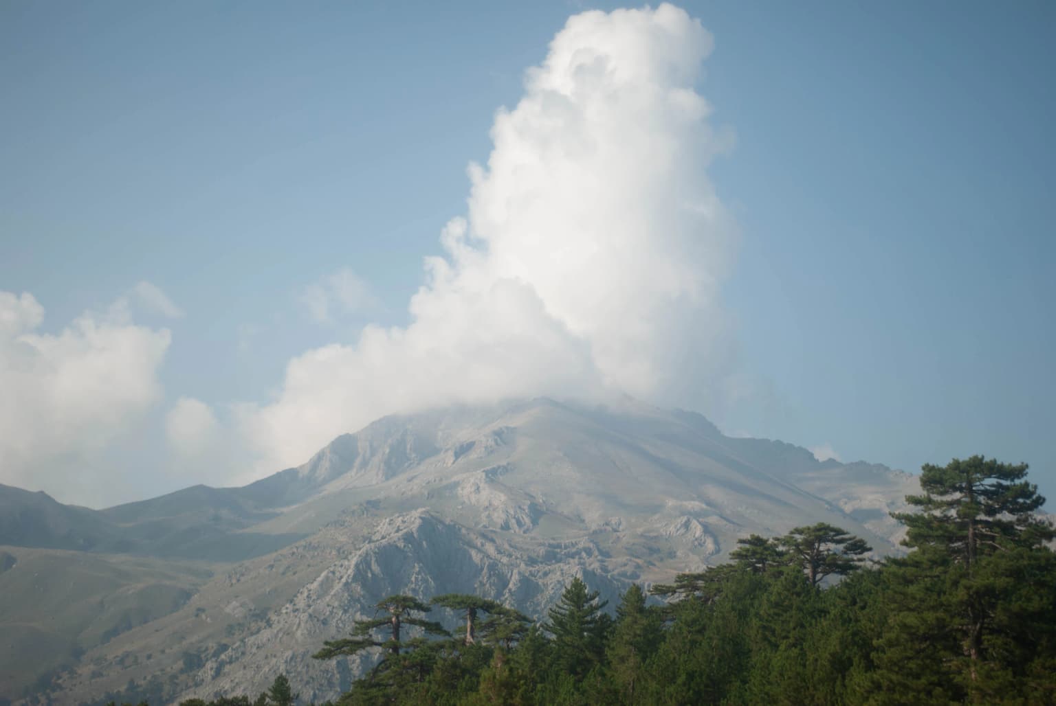
The landscape of Kızıldağ National Park is characterized by dramatic mountainous terrain of the Taurus Ranges in southern Turkey. The park encompasses steep slopes, deep valleys, and high-elevation ridgelines that create a visually striking alpine environment. The dominant topographic feature is Dedegöl Mountain, also known as Dipoyraz, which rises to approximately 2,980 meters within the park boundaries. This significant peak serves as a major landmark visible from surrounding areas and represents the highest elevations within the protected area. The terrain supports forest cover that transitions from denser woodlands at mid-elevations to more sparse alpine vegetation near the summits. The combination of rugged peaks, forested slopes, and the overall wilderness character distinguishes Kızıldağ as a representative example of Taurus Mountain landscape protection in Turkey.

Snow-covered evergreen trees with a town visible in the distance under a cloudy sky
Snow-covered evergreen trees with a view of a town and distant mountains in Kızıldağ National Park

Kızıldağ National Park ecosystems, habitats, and plant life

Kızıldağ National Park supports diverse forest ecosystems that reflect the transitional nature of its location between Mediterranean and more continental climatic zones. The vegetation is characterized by black pine, several cedar species, oak, and juniper, creating a structurally and compositionally varied forest cover across the park's elevation gradient. The blue-leaf cedar forests within Kızıldağ hold particular significance, as this distinctive cedar type occurs in only a few locations throughout Turkey. These forests represent an important vegetation community that the park was specifically established to protect. The habitat diversity created by the mountain terrain, with its varying aspects, elevations, and microclimates, supports a range of ecological communities from montane forests through subalpine zones. This environmental heterogeneity contributes to the park's conservation value within the broader Mediterranean basin.

Kızıldağ National Park wildlife and species highlights

The wildlife community within Kızıldağ National Park reflects the diverse forest and mountain habitats of the Taurus region. Large mammals present in the park include wolves and jackals, representing significant predator populations within the protected area. Smaller mammals such as foxes and martens also occur throughout the park's forested terrain. The bird fauna includes several notable species of prey birds, with eagles, vultures, hawks, falcons, and owls all documented within the park boundaries. These raptorial species benefit from the diverse habitat structure and the availability of suitable nesting sites on the steep terrain. The combination of forested habitats for cover and open areas for hunting supports a functional ecosystem for both resident and migratory bird species.

Kızıldağ National Park conservation status and protection priorities

Kızıldağ National Park serves as an important protected area within Turkey's national park system, preserving representative examples of Taurus Mountain forest and alpine ecosystems. The protection of the blue-leaf cedar forests represents a specific conservation priority, as this vegetation type has limited distribution nationally. The park's designation in 1969 reflected early recognition of the need to preserve significant natural areas in Turkey, and its continued management under the Ministry of Forest and Water Management ensures ongoing protection for the area's ecological values. The presence of viable populations of wolves and other wildlife, along with the diverse forest communities, indicates that the protected area maintains ecological integrity. Boundary adjustments made in 2018 demonstrate active management attention to optimizing the park's configuration for conservation effectiveness.

Kızıldağ National Park cultural meaning and human context

Kızıldağ National Park is situated within a region of southwestern Turkey that maintains connections to traditional land use practices, though the park itself is designated for nature protection rather than cultural preservation. The park encompasses portions of the Taurus Mountains that have historically supported pastoral activities and resource use by local communities. The surrounding districts of Yenişarbademli, Şarkikaraağaç, and Aksu include communities whose economies have traditionally included agriculture and livestock management. The park's establishment formalized the protection of these mountain landscapes while the surrounding regions continue to maintain their cultural identity tied to the local terrain and natural resources.

Top sights and standout views in Kızıldağ National Park

Kızıldağ National Park preserves one of Turkey's significant mountain wilderness areas within the Taurus Ranges. The park features the prominent Dedegöl Mountain peak at nearly 3,000 meters, offering dramatic alpine scenery. The blue-leaf cedar forests represent a unique vegetation type found in few other locations in Turkey. The protected area supports wolf and jackal populations along with diverse birds of prey including eagles and vultures. As one of Turkey's oldest national parks established in 1969, Kızıldağ represents a pioneering effort in the country's modern conservation history. The park provides habitat protection for forest ecosystems transitioning from Mediterranean montane conditions to subalpine zones.

Best time to visit Kızıldağ National Park

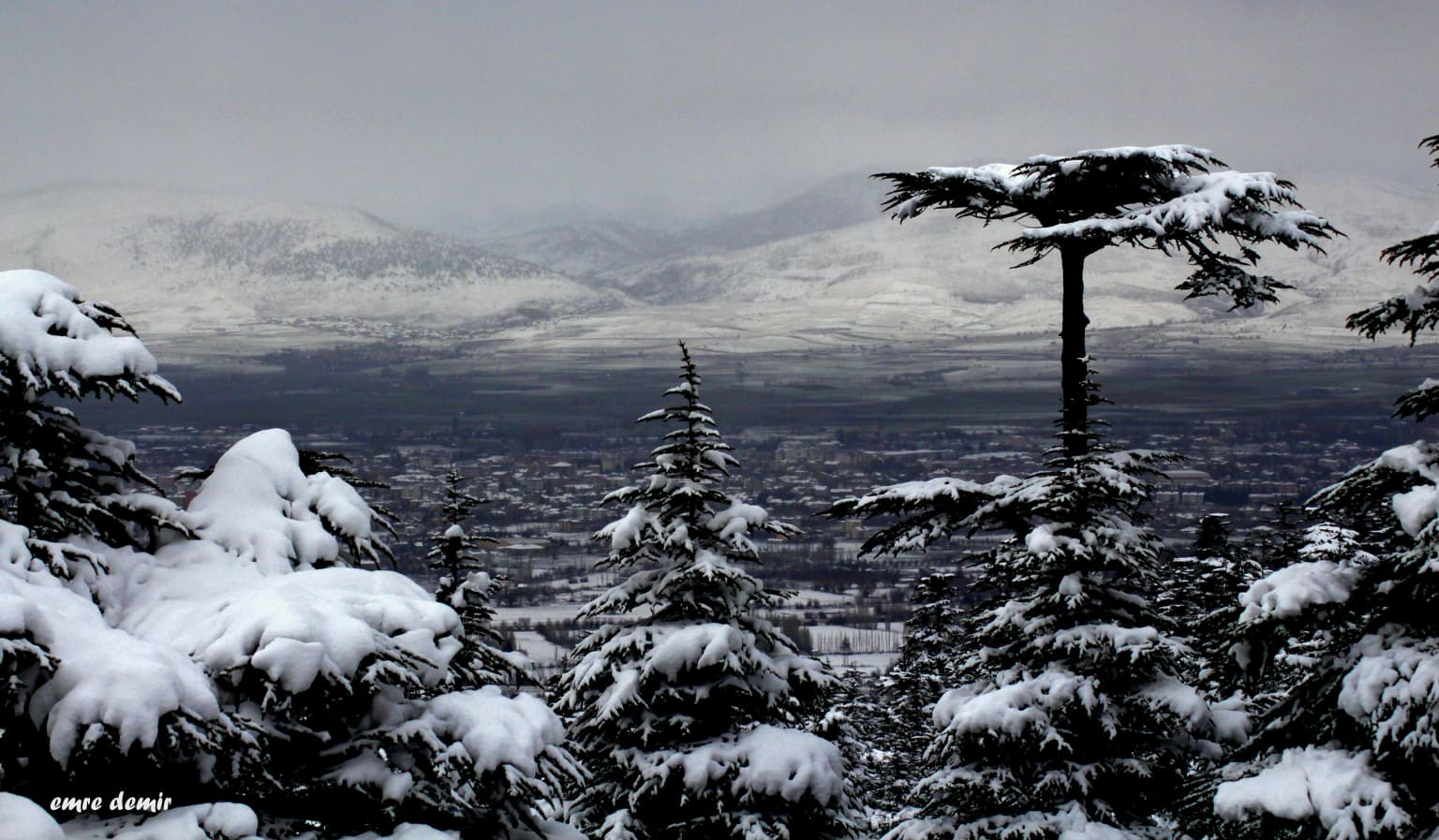
Kızıldağ National Park can be visited throughout the year, with each season offering distinct experiences of the mountain landscape. The summer months typically provide the most accessible conditions for exploring the park's trails and higher elevations, with warmer temperatures and generally clear weather. Spring brings blooming vegetation and活跃的野生动物 activity as the park emerges from winter conditions. Autumn offers colorful forest scenery as the deciduous elements change, with comfortable temperatures for outdoor activities. Winter conditions in the higher elevations can be severe, with snow cover and cold temperatures limiting access to some areas but providing opportunities for those interested in winter mountain environments. The best overall conditions for general visitation typically occur from late spring through early autumn.

Park location guide

Geography guide, regional context, and park location map for Kızıldağ National Park

Kızıldağ National Park park geography, regions, and map view in Turkey
Understand where Kızıldağ National Park sits in Turkey through a broader geographic reading of the surrounding landscape, nearby location context, and its mapped position within the national park landscape.

How Kızıldağ National Park fits into Turkey

Turkey, officially the Republic of Türkiye, is a transcontinental country located mainly in Anatolia (West Asia) with a smaller portion in East Thrace (Southeast Europe). It borders the Black Sea to the north, several countries to the east and south, and the Aegean Sea and European countries to the west. The country has a population of over 86 million and operates as a secular, Muslim-majority presidential republic with Ankara as capital and Istanbul as its largest city.

Wider geography shaping Kızıldağ National Park in Turkey

Turkey is a transcontinental country with the majority of its territory (about 97%) located in Anatolia (West Asia) and a smaller portion called East Thrace in Southeast Europe. It borders the Black Sea to the north, Georgia, Armenia, Azerbaijan, and Iran to the east, Iraq and Syria to the south, and the Mediterranean Sea to the southwest. To the west, Turkey borders the Aegean Sea, Greece, and Bulgaria. The terrain includes mountains, plateaus, and coastal plains, with the Taurus Mountains running along the southern coast.

Map view of Kızıldağ National Park

Use this park location map to pinpoint Kızıldağ National Park in Turkey, understand its exact geographic position, and read its mapped placement within the surrounding landscape more clearly.

Pigeon | © OpenStreetMap contributors

Location context for Kızıldağ National Park

Isparta Province

Visually immerse yourself in the dramatic alpine terrain and distinct blue-leaf cedar forests that define this significant Turkish protected area.

Kızıldağ National Park Photos: Explore the Rugged Taurus Mountain Landscapes and Unique Cedar Forests
Explore the visual identity of Kızıldağ National Park, uncovering its rugged Taurus Mountain landscapes, unique blue-leaf cedar forests, and diverse alpine habitats. These images offer crucial insight into the park's terrain and protected-area character, enhancing your understanding of this significant Turkish wilderness.

Mountain peak with clouds, forested foreground, and clear blue sky

Landscape view of Kızıldağ National Park with rolling hills, scattered trees, and distant mountains under clear blue sky

Snow-covered evergreen trees with a town visible in the distance under a cloudy sky

Park atlas

Trace the regional geography and connected protected landscapes surrounding Kızıldağ National Park within Turkey's Isparta Province.

Discover Nearby National Parks and Protected Areas Beyond Kızıldağ National Park
Explore other national parks and protected areas near Kızıldağ National Park, tracing their geographic spread across Turkey's Taurus Mountains region. Compare diverse mountain wilderness, forest ecosystems, and conservation landscapes, gaining deeper insight into the protected-area context of southern Turkey.
Watercolor painting of colorful rowboats on a lake with distant mountains
National parkKonya Province

Lake Beyşehir National Park: Protected Landscape Geography and Mapped Boundaries

Discover the geography and mapped context of this national park in Konya.

Lake Beyşehir National Park is a major protected area in Turkey's Central Anatolia region, celebrated for its immense freshwater lake and diverse wetland habitats. The park's identity is strongly tied to its mapped boundaries that protect critical ecosystems, islands, and surrounding forested terrain. This page provides a detailed look at the park's geographic setting within Konya Province, serving as a valuable resource for atlas-based discovery of its unique natural and cultural landscape.

Area
868.55 km²
Established
1993
Relief
Lowland
Climate
Temperate
Watercolor painting showing a lake, mountains, trees, and grassy shoreline
National parkIsparta Province

Lake Kovada National Park: Mapped Protected Landscape in Isparta Province

Discover the geography and lake ecosystem of this Turkish national park.

Lake Kovada National Park offers a detailed look at a protected natural area within Turkey's Isparta Province. This page provides insights into the park's protected landscape, focusing on the central freshwater lake and its surrounding montane terrain. Explore its geographic context, mapped boundaries, and status as a significant protected area within the Taurus Mountain region, ideal for atlas-based discovery of Anatolian natural environments.

Area
65.51 km²
Established
1970
Scope
Terrestrial
Water
Major water bodies
National parkTurkey

Derebucak Çamlık Caves National Park: Turkey's Protected Karst Caves and Landscape

Explore Konya Province's longest cave system and its unique geological context.

Derebucak Çamlık Caves National Park is a vital protected landscape in central Turkey, celebrated for its extensive karst topography and significant cave formations. This national park encompasses thirteen unique caves and sinkholes, with Balatini Cave holding the distinction of being Konya Province's longest. The park's rugged terrain, characterized by pine forests and the Balat Stream feeding its underground systems, offers a profound look into Turkey's geological heritage and the conservation of its unique subterranean environments. MoriAtlas helps you navigate this mapped protected area.

Area
11.47 km²
Established
2022
Watercolor illustration showing a mountainous landscape with a lake and greenery
National parkAntalya Province

Altınbeşik Cave National Park: A Karst Landscape with Turkey's Largest Subterranean Lake

Protected lands and mapped geological formations in Antalya Province.

Altınbeşik Cave National Park represents a significant protected karst landscape within Antalya Province, Turkey. The park's primary feature is the renowned Altınbeşik Cave, home to Turkey's largest subterranean lake and exceptional travertine formations. Explore the mapped geography of this unique national park, understanding its role as a critical discharge point for one of the world's longest karst aquifer systems.

Area
11.47 km²
Established
1994
Relief
Mixed relief
Climate
Mediterranean
Protected areaTurkey

Commander-in-Chief National Historic Park: Historic Battlefield Landscape in Turkey

Protected Area preserving pivotal geography and military history.

Commander-in-Chief National Historic Park is a designated protected area in Turkey, preserving the historic terrain of the decisive Battle of Dumlupınar. This site offers a unique glimpse into the geography and landscape that were instrumental in a key moment of the Turkish War of Independence. Explore the mapped context of this significant battlefield, understanding its role within the broader Anatolian geography and its importance as a preserved historic site.

Area
409.48 km²
Established
1981
Relief
Mixed relief
Climate
Temperate
National parkAnkara Province

Mount Sarıçalı National Park: Turkey's Newest Protected Mountain Landscape

Ancient forests, endemic botany, and dramatic mountain terrain.

Mount Sarıçalı National Park, located in Ankara Province, Turkey, is a testament to the nation's commitment to conservation. This protected area is celebrated for its ancient forests, with larch, Kasnak oak, and juniper trees dating back 700-800 years. Its position at the confluence of three phytogeographic zones supports a rich array of 139 endemic plant species. The park's landscape is further characterized by the striking Uyuzsuyu Waterfall and the imposing Mount Sarıçalı peak, offering a profound geographic context for atlas exploration.

Area
10.24 km²
Established
2021
Relief
Mountain
Scope
Terrestrial
Watercolor painting of a river flowing through green hills and mountains under a soft sky.
National parkMuğla Province

Saklıkent National Park: Explore Turkey's Deepest Gorge, Limestone Formations, and Protected Terrain

A remarkable national park showcasing dramatic canyon geography and karst landscapes.

Saklıkent National Park presents an extraordinary example of a protected landscape dominated by a deep limestone canyon in Muğla Province, Turkey. This national park invites exploration of its striking geological features, including towering cliffs and flowing karstic springs that form a spectacular gorge. Users engaging with Saklıkent National Park gain insight into the mapped boundaries of protected areas and the unique natural terrain sculpted by water over millennia, offering a rich geographic context for atlas discovery.

Area
16.43 km²
Established
1996
Visitors
200K annual
Relief
Mountain
Watercolor painting of a lake surrounded by green hills and trees with colorful foliage
National parkBolu Province

Lake Abant National Park: Protected Volcanic Crater Lake & Alpine Landscape

Bolu Province, Turkey | National Park | Mapped Landscape

Lake Abant National Park is a protected national park renowned for its stunning volcanic crater lake and surrounding alpine forests within Bolu Province. This detailed entry provides insight into the park's geographic context, its unique volcanic terrain, and its status as a protected landscape. Explore the mapped boundaries and understand the ecological significance of this distinctive natural area in northwestern Turkey.

Area
11.965 km²
Established
2022
Relief
Mountain
Climate
Temperate

Common questions about visiting, size, designation, and location context for Kızıldağ National Park

Kızıldağ National Park FAQs for park facts, access, geography, and protected area context
Find quick answers about Kızıldağ National Park, including protected-area facts, park geography, trail and visitor context, and how the park fits into its surrounding country and regional landscape.
MoriAtlas Explorer

Continue Your Protected Areas Search Across the Global Atlas

Deepen your exploration by continuing the structured search for national parks and protected areas worldwide. Utilize the comprehensive filtering capabilities to compare different conservation landscapes and refine your understanding of global park geography. Discover more about the distribution and characteristics of protected natural areas.

Global natural geography