Mori Atlas logo
National parkDerebucak Çamlık Caves National Park

Explore the mapped boundaries and unique terrain of Konya Province's premier natural cave system.

Derebucak Çamlık Caves National Park: Turkey's Karst Cave System and Protected Landscape

(Derebucak Çamlık Mağaraları Millî Parkı)

Derebucak Çamlık Caves National Park represents a significant protected area within Turkey's diverse geography, safeguarding a remarkable karst landscape. This national park, established to conserve its geological heritage, features thirteen distinct caves and sinkholes, including Balatini Cave, recognized as the longest in Konya Province. Situated on the southeastern slopes of the Western Taurus Mountains near Çamlık village, the park's terrain is sculpted by underground river systems like the Balat Stream, creating a unique subterranean environment set against rugged pine-forested slopes. Its protected status highlights its importance for understanding cave ecosystems and Turkey's conservation efforts.

karst landscapecave systemnational parkTurkeyKonya Provincegeological heritage

Derebucak Çamlık Caves National Park

National park

Park overview

Structured park overview, official facts, and landscape profile for Derebucak Çamlık Caves National Park

Derebucak Çamlık Caves National Park park facts, protected area profile, and essential visitor context
Review the core facts for Derebucak Çamlık Caves National Park, including designation, size, terrain, visitor scale, habitats, and operating context in one park-focused overview.

About Derebucak Çamlık Caves National Park

Derebucak Çamlık Caves National Park occupies a distinctive position in Turkey's protected area network as the 47th national park, established in 2022 to preserve a remarkable underground landscape in central Anatolia. The park is situated in the Derebucak district of Konya Province, approximately 1.5 kilometers from the Çamlık village, on the southeastern flanks of the Akdağlar range within the Western Taurus Mountains. The area encompasses 1,147 hectares of karst terrain characterized by sinkholes, caves, and the surface water flow of Balat Stream, which sustains the cave system's hydrology. The cave group has been recognized as a natural monument since 2013, reflecting its long-standing geological significance. The national park administration falls under the Directorate-General of Nature Protection and National Parks at the Ministry of Agriculture and Forestry. The caves vary considerably in character: Balatini Cave provides the longest underground passage in the region, while Suluin Cave offers ornate formations and seasonal boating opportunities. Other significant caves include Mastaltı Cave and Dede Tarlası Sinkhole, which offer vertical and semi-inclined experiences suitable for guided descents. The park's steep terrain creates diverse habitats supporting wildlife including globally endangered species.

Quick facts and research context for Derebucak Çamlık Caves National Park

Located in central Anatolia's Konya Province, Derebucak Çamlık Caves National Park protects 13 significant caves and sinkholes on the Akdağlar mountain range. The park was established in 2022 as Turkey's 47th national park, following natural monument protection since 2013. The area features karst geology with Balatini Cave holding the distinction of being the longest cave in Konya. The landscape supports endangered wildlife including the wild goat and endemic Woolly Rock Sleeper, while the broader region forms part of an Important Bird Area.

Park context

Deeper park guide and search-rich context for Derebucak Çamlık Caves National Park

Derebucak Çamlık Caves National Park history, landscape, wildlife, and travel context
Explore Derebucak Çamlık Caves National Park through its history, landscape character, ecosystems, wildlife, conservation priorities, cultural context, and seasonal travel timing in a structured park guide built for atlas discovery and search intent.

Why Derebucak Çamlık Caves National Park stands out

Derebucak Çamlık Caves National Park is best known for its exceptional karst cave system, which stands as the longest in Konya Province. The park protects 13 caves and sinkholes with remarkable geomorphological diversity, ranging from ornate caverns like Suluin Cave, popular for boating excursions, to vertical caves ideal for guided caving experiences. The area represents one of Turkey's most significant cave-protected landscapes, combining geological importance with ecological value in a relatively newly established national park.

Derebucak Çamlık Caves National Park history and protected-area timeline

The caves comprising what is now Derebucak Çamlık Caves National Park were first protected as a natural monument on November 29, 2013, recognizing their significant geological and natural value within Turkey's protected area framework. Following nearly a decade of protection under this designation, the area was elevated to national park status on June 7, 2022, becoming the 47th national park in Turkey. This designation reflected the comprehensive conservation importance of the cave system and surrounding landscape, integrating the underground formations within Turkey's broader national park network managed by the Ministry of Agriculture and Forestry. The park represents a relatively recent addition to Turkey's protected areas, established with the goal of preserving both the geological heritage and ecological diversity of this karst landscape in central Anatolia.

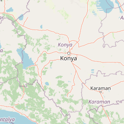
Derebucak Çamlık Caves National Park landscape and geographic character

The park's landscape is defined by karst topography characteristic of the Western Taurus Mountains' southeastern slopes. The terrain features rugged, steep slopes that create diverse microhabitats throughout the 1,147-hectare protected area. The Balat Stream traverses the park, feeding the karst system and supporting the cave formations with year-round water flow. The surface landscape includes pine forest coverage and exposed limestone formations typical of karst regions. Sinkholes and cave entrances dot the terrain, marking the locations where the underground cave systems extend beneath the surface. The elevation and steepness of the land contribute to the ecological diversity by creating varied exposure, moisture conditions, and vegetation zones that support both cave-dependent species and surface-dwelling wildlife.

Derebucak Çamlık Caves National Park ecosystems, habitats, and plant life

The ecological character of Derebucak Çamlık Caves National Park reflects the transition between central Anatolia's continental climate and the Mediterranean influences of the Taurus region. The park's karst landscape supports a complex interplay of underground and surface ecosystems. Pine forests dominate the surface vegetation, while the cave systems provide unique subterranean habitats. The karst aquifer fed by Balat Stream sustains both the cave formations and the surrounding vegetation. The region's position between Derebucak, Çamlık, Akseki, and İbradı places it within one of Turkey's Important Bird Areas, indicating broader ecological significance beyond the immediate cave system protection.

Derebucak Çamlık Caves National Park wildlife and species highlights

The park provides habitat for several notable species, including the wild goat (Capra aegagrus), which is listed as endangered on a global scale and inhabits the steep rocky terrain within the protected area. The Woolly Rock Sleeper (Dryomys laniger), a mammal species endemic to Turkey's Mediterranean Region, also occurs in the park's forested and rocky habitats. The broader region encompassing the caves is recognized as an Important Bird Area, highlighting its significance for avian biodiversity. The steep terrain and varied habitats support these species while the cave system itself provides shelter and specialized microhabitats for cave-adapted organisms.

Derebucak Çamlık Caves National Park conservation status and protection priorities

Derebucak Çamlık Caves National Park represents a conservation priority for Turkey due to its dual recognition as both a natural monument (since 2013) and national park (since 2022). The protected status acknowledges the exceptional geological value of the 13 caves and sinkholes, which include the longest cave in Konya Province and formations of national significance. The karst ecosystem's conservation importance extends beyond the caves themselves to encompass the surrounding forests, wildlife habitats, and hydrological systems that sustain the underground formations. Protection of this area also preserves habitat for globally endangered species like the wild goat and the regionally endemic Woolly Rock Sleeper.

Derebucak Çamlık Caves National Park cultural meaning and human context

The park is located in the Derebucak district of Konya Province, within the traditional boundaries of central Anatolia. The cave system near Çamlık village has been a recognized geological feature of local significance for decades before formal protection began in 2013. The Turkish name Derebucak Çamlık Mağaraları Millî Parkı reflects the park's identity tied to both the Derebucak area and the Çamlık locality.

Top sights and standout views in Derebucak Çamlık Caves National Park

The park's most notable feature is its remarkable cave system with 13 significant caves and sinkholes, including Balatini—the longest cave in Konya—and Suluin Cave with its ornate formations and summer boating opportunities. The karst landscape, pine forests, and endangered wildlife including the wild goat and endemic Woolly Rock Sleeper add ecological value. The area's inclusion in Turkey's Important Bird Area network further demonstrates its broader conservation significance within the Central Anatolian landscape.

Best time to visit Derebucak Çamlık Caves National Park

The park can be visited throughout the year, though summer months offer the most comfortable conditions for exploring the caves and surface trails. Suluin Cave becomes particularly popular for boating activities during the summer when increased tourism coincides with favorable weather in the mountain environment. The cooler months provide excellent conditions for caving activities and wildlife observation, while the karst landscape displays different character across seasons as water flow through the cave system varies.

Park location guide

Geography guide, regional context, and park location map for Derebucak Çamlık Caves National Park

Derebucak Çamlık Caves National Park park geography, regions, and map view in Turkey
Understand where Derebucak Çamlık Caves National Park sits in Turkey through a broader geographic reading of the surrounding landscape, nearby location context, and its mapped position within the national park landscape.

How Derebucak Çamlık Caves National Park fits into Turkey

Turkey, officially the Republic of Türkiye, is a transcontinental country located mainly in Anatolia (West Asia) with a smaller portion in East Thrace (Southeast Europe). It borders the Black Sea to the north, several countries to the east and south, and the Aegean Sea and European countries to the west. The country has a population of over 86 million and operates as a secular, Muslim-majority presidential republic with Ankara as capital and Istanbul as its largest city.

Wider geography shaping Derebucak Çamlık Caves National Park in Turkey

Turkey is a transcontinental country with the majority of its territory (about 97%) located in Anatolia (West Asia) and a smaller portion called East Thrace in Southeast Europe. It borders the Black Sea to the north, Georgia, Armenia, Azerbaijan, and Iran to the east, Iraq and Syria to the south, and the Mediterranean Sea to the southwest. To the west, Turkey borders the Aegean Sea, Greece, and Bulgaria. The terrain includes mountains, plateaus, and coastal plains, with the Taurus Mountains running along the southern coast.

Map view of Derebucak Çamlık Caves National Park

Use this park location map to pinpoint Derebucak Çamlık Caves National Park in Turkey, understand its exact geographic position, and read its mapped placement within the surrounding landscape more clearly.

Pigeon | © OpenStreetMap contributors

Location context for Derebucak Çamlık Caves National Park

Konya Province
Park atlas

Browse mapped protected landscapes and compare national parks across Central Anatolia, Turkey, expanding beyond karst cave systems.

Other National Parks and Protected Areas Near Derebucak Çamlık Caves National Park, Turkey
Explore other national parks and protected areas located throughout Turkey, comparing their unique geological features, varied landscapes, and conservation focuses. Expand your geographic understanding beyond Derebucak Çamlık Caves National Park by tracing the distribution of protected landscapes across Central Anatolia and wider Turkish regions.
Watercolor illustration showing a mountainous landscape with a lake and greenery
National parkAntalya Province

Altınbeşik Cave National Park: A Karst Landscape with Turkey's Largest Subterranean Lake

Protected lands and mapped geological formations in Antalya Province.

Altınbeşik Cave National Park represents a significant protected karst landscape within Antalya Province, Turkey. The park's primary feature is the renowned Altınbeşik Cave, home to Turkey's largest subterranean lake and exceptional travertine formations. Explore the mapped geography of this unique national park, understanding its role as a critical discharge point for one of the world's longest karst aquifer systems.

Area
11.47 km²
Established
1994
Relief
Mixed relief
Climate
Mediterranean
Watercolor painting of colorful rowboats on a lake with distant mountains
National parkKonya Province

Lake Beyşehir National Park: Protected Landscape Geography and Mapped Boundaries

Discover the geography and mapped context of this national park in Konya.

Lake Beyşehir National Park is a major protected area in Turkey's Central Anatolia region, celebrated for its immense freshwater lake and diverse wetland habitats. The park's identity is strongly tied to its mapped boundaries that protect critical ecosystems, islands, and surrounding forested terrain. This page provides a detailed look at the park's geographic setting within Konya Province, serving as a valuable resource for atlas-based discovery of its unique natural and cultural landscape.

Area
868.55 km²
Established
1993
Relief
Lowland
Climate
Temperate
Watercolor painting showing a lake, mountains, trees, and grassy shoreline
National parkIsparta Province

Lake Kovada National Park: Mapped Protected Landscape in Isparta Province

Discover the geography and lake ecosystem of this Turkish national park.

Lake Kovada National Park offers a detailed look at a protected natural area within Turkey's Isparta Province. This page provides insights into the park's protected landscape, focusing on the central freshwater lake and its surrounding montane terrain. Explore its geographic context, mapped boundaries, and status as a significant protected area within the Taurus Mountain region, ideal for atlas-based discovery of Anatolian natural environments.

Area
65.51 km²
Established
1970
Scope
Terrestrial
Water
Major water bodies
Watercolor illustration of green hills, pine trees, and distant mountains under a light sky
National parkIsparta Province

Kızıldağ National Park: Protected Taurus Mountain Landscape and Atlas Context

Mapped boundaries, alpine terrain, and unique cedar forests.

Kızıldağ National Park offers a detailed look into Turkey's protected natural heritage, specifically highlighting the dramatic mountainous terrain of the Taurus Ranges. This page provides atlas-level geographic information about its mapped boundaries, the significant Dedegöl Mountain, and the rare blue-leaf cedar forests unique to this region. Understand its role as a vital conservation area within Isparta Province and the broader Mediterranean mountain ecosystem.

Area
551.06 km²
Established
1969
Relief
Mountain
Scope
Terrestrial
Protected areaTurkey

Commander-in-Chief National Historic Park: Historic Battlefield Landscape in Turkey

Protected Area preserving pivotal geography and military history.

Commander-in-Chief National Historic Park is a designated protected area in Turkey, preserving the historic terrain of the decisive Battle of Dumlupınar. This site offers a unique glimpse into the geography and landscape that were instrumental in a key moment of the Turkish War of Independence. Explore the mapped context of this significant battlefield, understanding its role within the broader Anatolian geography and its importance as a preserved historic site.

Area
409.48 km²
Established
1981
Relief
Mixed relief
Climate
Temperate
Watercolor painting of a river flowing through green hills and mountains under a soft sky.
National parkMuğla Province

Saklıkent National Park: Explore Turkey's Deepest Gorge, Limestone Formations, and Protected Terrain

A remarkable national park showcasing dramatic canyon geography and karst landscapes.

Saklıkent National Park presents an extraordinary example of a protected landscape dominated by a deep limestone canyon in Muğla Province, Turkey. This national park invites exploration of its striking geological features, including towering cliffs and flowing karstic springs that form a spectacular gorge. Users engaging with Saklıkent National Park gain insight into the mapped boundaries of protected areas and the unique natural terrain sculpted by water over millennia, offering a rich geographic context for atlas discovery.

Area
16.43 km²
Established
1996
Visitors
200K annual
Relief
Mountain
National parkMuğla Province

Marmaris National Park: Mediterranean Forest Protected Landscape and Ancient Heritage

Discover its geography, mapped boundaries, and unique flora.

Marmaris National Park in Muğla Province offers a deep dive into a protected Mediterranean forest ecosystem and Carian history. Explore its rugged terrain, dramatic coastlines where pine forests meet the sea, and discover ancient sites like the Amos amphitheatre. This park is a key area for understanding regional geography, mapped natural landscapes, and the unique botanical diversity of Turkey's southwestern coast, supporting detailed atlas exploration.

Area
333.5 km²
Established
1996
Visitors
8.5M annual
Relief
Mixed relief
National parkTurkey

Aladağlar National Park: Turkey's Dramatic Alpine Protected Landscape

Rugged terrain and crimson peaks in the Anti-Taurus Mountains.

Delve into Aladağlar National Park, a significant protected area defined by its striking alpine environment within Turkey's Anti-Taurus range. This park is renowned for its rugged, high-altitude wilderness, characterized by dramatic granite peaks that display a unique crimson coloration, especially at sunset. Its landscape features steep valleys, alpine lakes formed from snowmelt, and challenging mountaineering opportunities. MoriAtlas offers detailed map context to appreciate the geographic distinctiveness and ecological importance of this elevated protected terrain.

Area
550.65 km²
Established
1995
Relief
Mountain
Climate
Alpine

Common questions about visiting, size, designation, and location context for Derebucak Çamlık Caves National Park

Derebucak Çamlık Caves National Park FAQs for park facts, access, geography, and protected area context
Find quick answers about Derebucak Çamlık Caves National Park, including protected-area facts, park geography, trail and visitor context, and how the park fits into its surrounding country and regional landscape.
MoriAtlas Explorer

Continue Your Protected Areas Search Across the Global Atlas

Deepen your exploration by continuing the structured search for national parks and protected areas worldwide. Utilize the comprehensive filtering capabilities to compare different conservation landscapes and refine your understanding of global park geography. Discover more about the distribution and characteristics of protected natural areas.

Global natural geography