Mori Atlas logo
National parkKazdağı National Park

Discover the mapped geography and diverse terrain of this significant national park in Turkey's Aegean region.

Kazdağı National Park: Turkey's Premier Protected Mountain Landscape and Ecosystem Atlas

Kazdağı National Park represents a vital protected landscape within Turkey's Aegean region, centered around the prominent Mount Ida. This national park protects a rich tapestry of diverse ecosystems, from dense subalpine forests climbing its slopes to exposed rocky terrain and alpine meadows near its summit. As a key watershed area and habitat, Kazdağı National Park's mapped boundaries encompass a significant mountain ecosystem, offering a clear point of reference for understanding the natural geography and protected land distribution in western Turkey.

National ParkMountain Protected AreaForest EcosystemAlpine EnvironmentTurkeyAegean Region
Colorful illustration of a mountain valley with waterfall and forested hills

Kazdağı National Park

National park

Park overview

Structured park overview, official facts, and landscape profile for Kazdağı National Park

Kazdağı National Park park facts, protected area profile, and essential visitor context
Review the core facts for Kazdağı National Park, including designation, size, terrain, visitor scale, habitats, and operating context in one park-focused overview.

About Kazdağı National Park

Kazdağı National Park protects the eponymous Mount Ida, a major mountain mass in western Turkey that rises prominently above the surrounding Aegean landscape. The protected area encompasses the mountain's upper slopes, summit areas, and the transitional forest zones that blanket its lower reaches. This mountain has long served as a landmark for the region, visible from the Aegean coast and serving as a natural boundary between the inland plateau and the coastal lowlands. The park's establishment reflects Turkey's commitment to preserving its significant mountain ecosystems and the biodiversity they support. The area provides important ecological services beyond conservation, including watershed protection and soil stabilization on the steep mountain slopes.

Quick facts and research context for Kazdağı National Park

Kazdağı National Park is situated in western Turkey's Balıkesir Province, protecting the iconic Mount Ida peak and its surrounding slopes. The park encompasses both subalpine forest zones and higher-elevation alpine terrain, creating a vertically diverse ecosystem. It serves as a critical watershed for the region, feeding streams and rivers that support surrounding agricultural lands. The area's conservation status reflects its importance as one of the remaining relatively intact mountain forest ecosystems in the Aegean region.

Park context

Deeper park guide and search-rich context for Kazdağı National Park

Kazdağı National Park history, landscape, wildlife, and travel context
Explore Kazdağı National Park through its history, landscape character, ecosystems, wildlife, conservation priorities, cultural context, and seasonal travel timing in a structured park guide built for atlas discovery and search intent.

Why Kazdağı National Park stands out

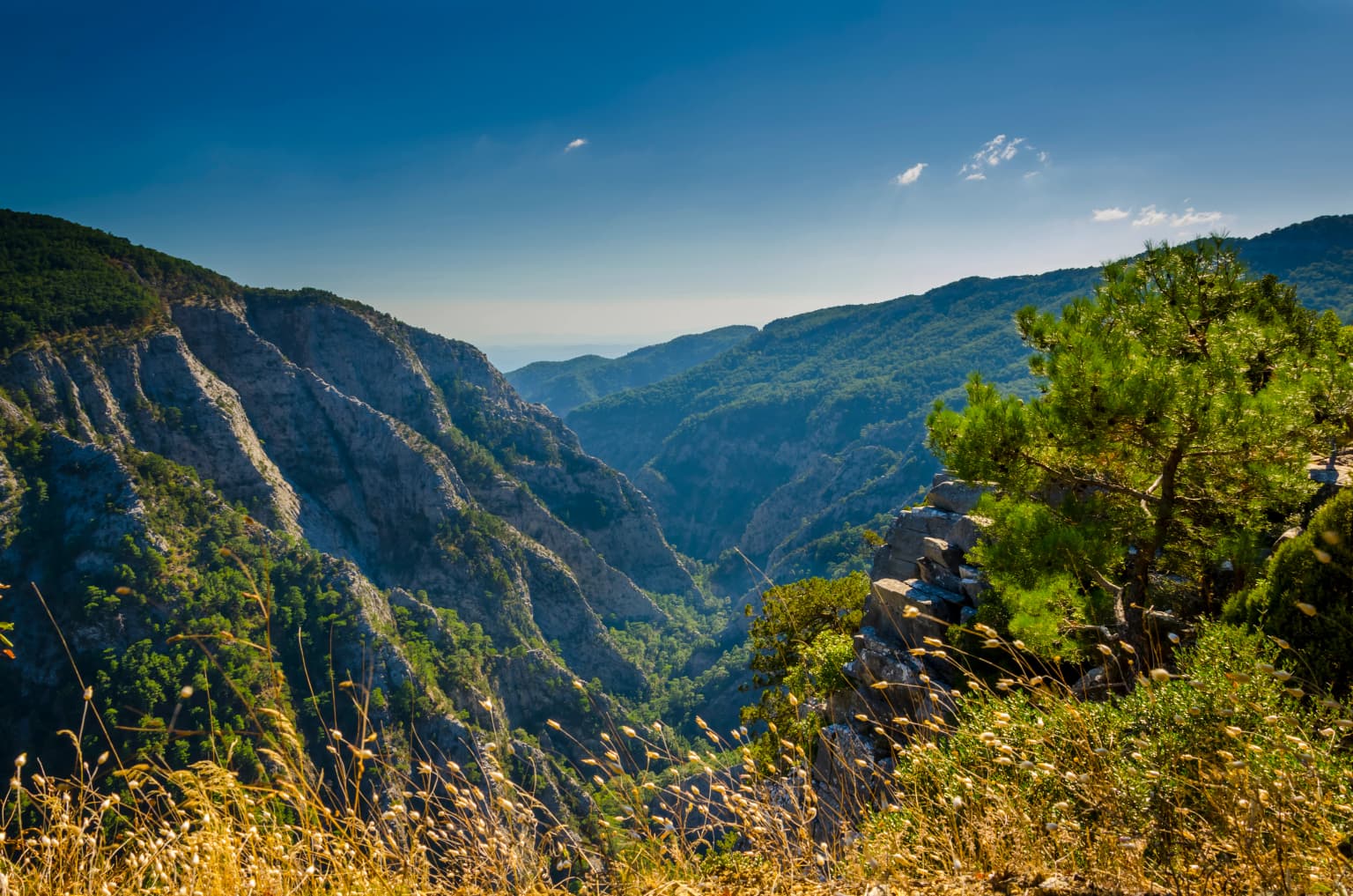
Kazdağı is best known for its impressive mountain landscape, where dense forests give way to rocky alpine summits and panoramic vistas across the Aegean region. The park protects one of Turkey's most significant subalpine forest ecosystems, with diverse conifer and deciduous species. Its elevation gradient creates distinct ecological zones, from valley forests to open alpine meadows. The mountain also holds historical significance as the classical Mount Ida, mentioned in ancient Greek mythology and literature.

A panoramic view of Şahinderesi Canyon with steep rocky cliffs, lush green vegetation, and a clear blue sky
View of Şahinderesi Canyon from Mount Ida within Kazdağı National Park, Turkey

Kazdağı National Park history and protected-area timeline

The establishment of Kazdağı National Park reflects Turkey's broader efforts in the latter half of the twentieth century to designate and protect representative natural areas across the country. The park was formally established to safeguard the mountain's distinctive ecosystems and landscapes from development pressures and unsustainable resource use. Prior to national park designation, the area had already received various forms of protective recognition due to its ecological significance and cultural importance.

Kazdağı National Park landscape and geographic character

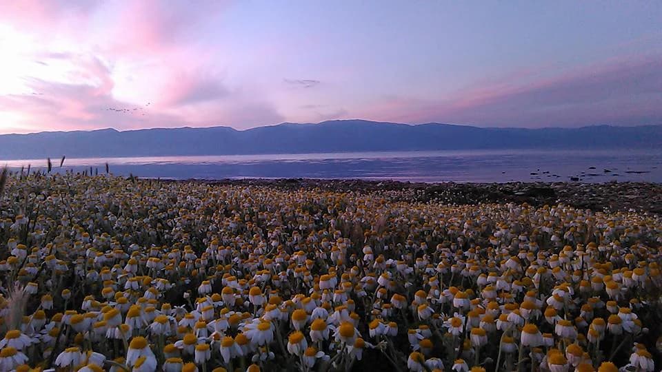
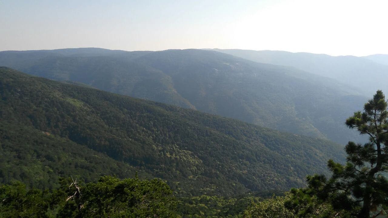
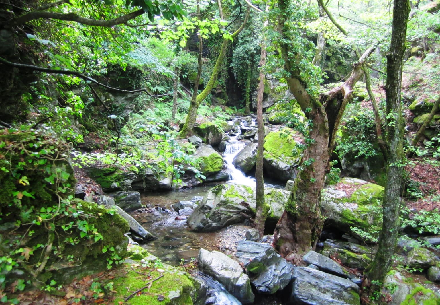
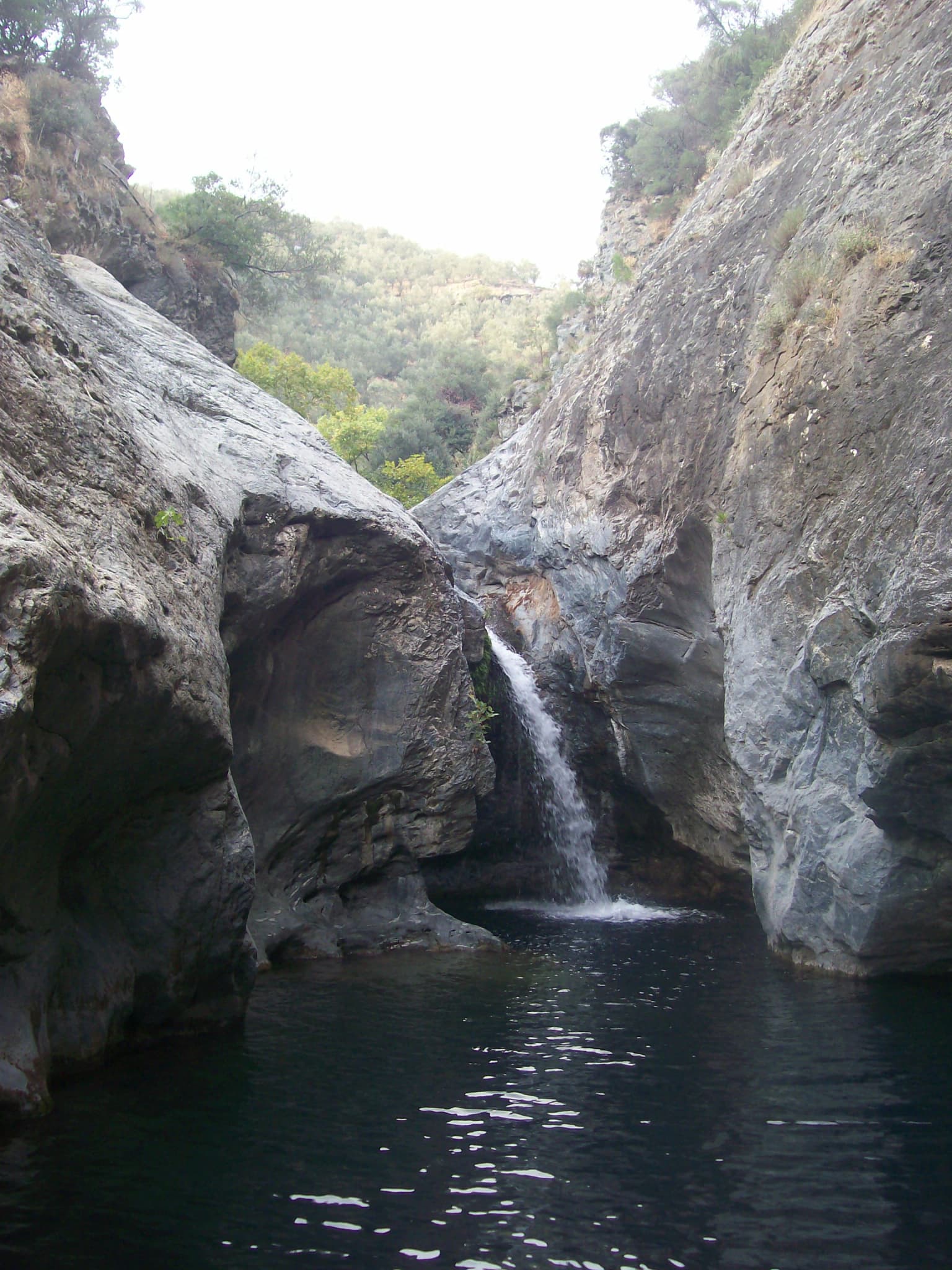
Mount Ida presents a dramatic mountain landscape characterized by steep, often rocky slopes that rise from the surrounding terrain. The mountain's geology creates a distinctive silhouette against the sky, with exposed rock formations and scree fields visible on higher slopes. The lower and middle elevations are covered in forest, while the summit zones transition to alpine vegetation or open rocky terrain. The landscape supports numerous seasonal streams that cascade down the mountain flanks, feeding into larger river systems in the valleys below.

Panoramic view of dense green forests and mountain ridges under a bright blue sky with scattered clouds
Eastward view across forested mountain ridges of Kazdağı National Park under a clear blue sky

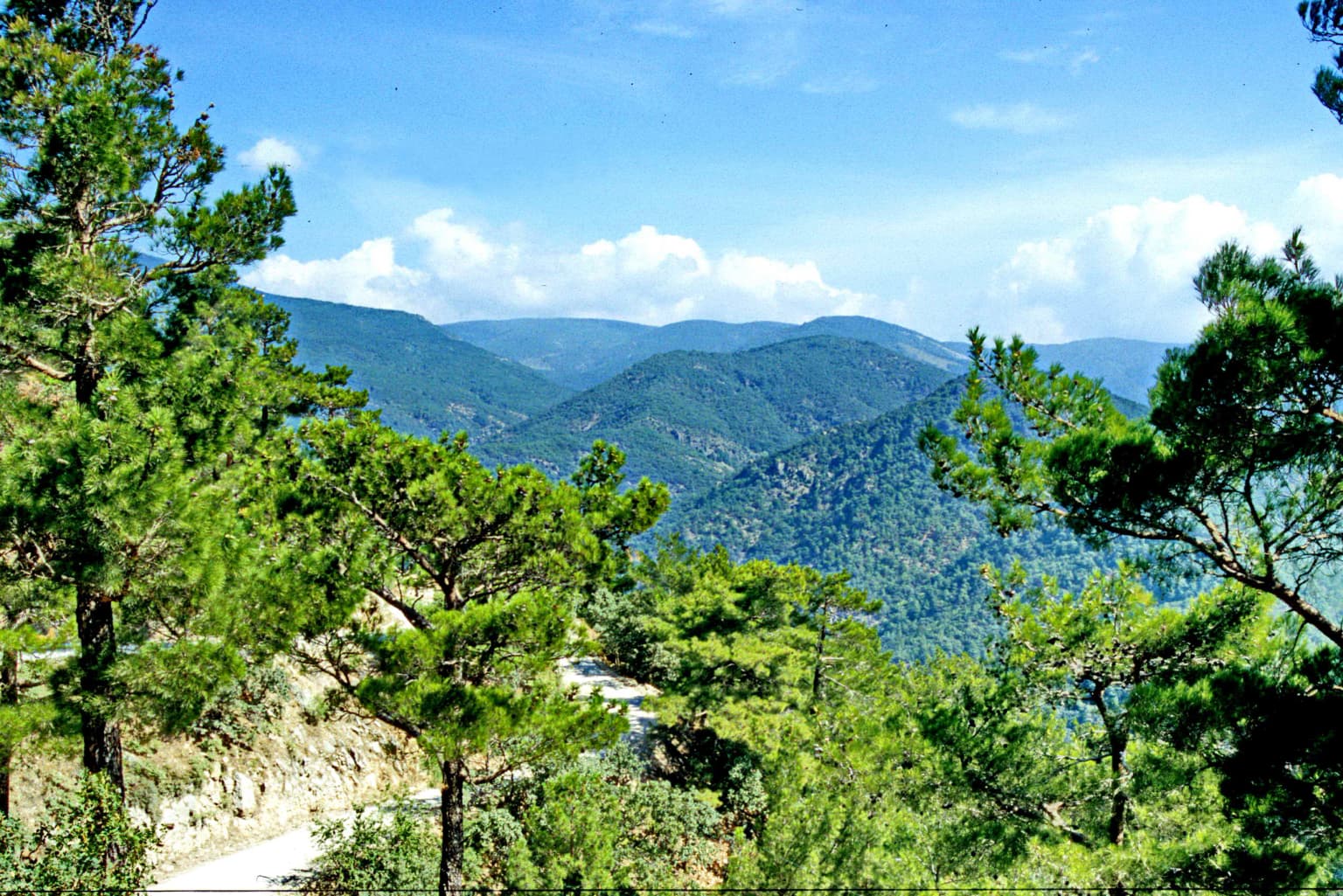
Kazdağı National Park ecosystems, habitats, and plant life

The park encompasses a vertically stratified ecosystem, with distinct vegetation zones corresponding to elevation. The lower slopes support mixed deciduous and coniferous forests, while higher elevations feature subalpine conditions with more open forest and meadow vegetation. This diversity of habitats supports a range of plant species adapted to different ecological conditions. The mountain also serves as an important watershed, capturing precipitation and releasing it gradually through springs and streams that benefit the broader region.

Field of yellow and white wildflowers with a body of water and distant mountains under a pink and purple sky
Coastal flower field at dawn with Mount Ida in the background, Kazdağı National Park

Kazdağı National Park wildlife and species highlights

The forests and alpine zones of Kazdağı provide habitat for a variety of wildlife species adapted to mountain environments. The diverse vegetation structure supports both forest-dwelling species and those that utilize the more open alpine areas. The region's position at the crossroads of different biogeographic zones contributes to species diversity.

Lush green mountain range with valleys under a clear sky, visible trees in the foreground
Panoramic view of Kaz Dağları mountain range from the park entrance

Kazdağı National Park conservation status and protection priorities

Kazdağı National Park represents an important conservation priority for Turkey, protecting one of the significant remaining mountain forest ecosystems in the Aegean region. The park's designation helps ensure the preservation of both the biological values of the mountain and the ecosystem services it provides, including water regulation and soil protection. Protecting this area also contributes to maintaining landscape connectivity in a region where development has reduced natural habitat extent.

Kazdağı National Park cultural meaning and human context

Mount Idle has held significance in regional culture and literature for centuries, appearing in classical Greek mythology and historical accounts as the mountain from which the gods observed the battles below. The local name Kazdağı and the older name Mount Ida both reflect the mountain's enduring presence in regional identity and cultural memory.

A forested stream with moss-covered rocks and lush green vegetation
A wild stream flowing through dense forest in Kazdağı National Park

Top sights and standout views in Kazdağı National Park

The park offers visitors the opportunity to experience a relatively untouched mountain ecosystem with visible ecological zonation from forest to alpine terrain. The summit of Mount Ida provides expansive views across the Aegean region, connecting the landscape to both mythological history and contemporary conservation. The combination of ecological significance, cultural resonance, and scenic beauty makes Kazdağı one of Turkey's notable protected mountain areas.

Waterfall flowing between large rocky cliffs into a dark pool of water with green vegetation in the background
Mıhlı Waterfall cascading into a dark pool between rocky cliffs in Kazdağı National Park

Best time to visit Kazdağı National Park

The summer months through early autumn typically offer the most favorable conditions for exploring Kazdağı, when weather is generally stable and the alpine meadows are accessible. Spring brings fresh vegetation and flowing streams but may have more changeable weather. Winter conditions on the mountain can be harsh, with snow cover limiting access to higher elevations.

Park location guide

Geography guide, regional context, and park location map for Kazdağı National Park

Kazdağı National Park park geography, regions, and map view in Turkey
Understand where Kazdağı National Park sits in Turkey through a broader geographic reading of the surrounding landscape, nearby location context, and its mapped position within the national park landscape.

How Kazdağı National Park fits into Turkey

Turkey, officially the Republic of Türkiye, is a transcontinental country located mainly in Anatolia (West Asia) with a smaller portion in East Thrace (Southeast Europe). It borders the Black Sea to the north, several countries to the east and south, and the Aegean Sea and European countries to the west. The country has a population of over 86 million and operates as a secular, Muslim-majority presidential republic with Ankara as capital and Istanbul as its largest city.

Wider geography shaping Kazdağı National Park in Turkey

Turkey is a transcontinental country with the majority of its territory (about 97%) located in Anatolia (West Asia) and a smaller portion called East Thrace in Southeast Europe. It borders the Black Sea to the north, Georgia, Armenia, Azerbaijan, and Iran to the east, Iraq and Syria to the south, and the Mediterranean Sea to the southwest. To the west, Turkey borders the Aegean Sea, Greece, and Bulgaria. The terrain includes mountains, plateaus, and coastal plains, with the Taurus Mountains running along the southern coast.

Map view of Kazdağı National Park

Use this park location map to pinpoint Kazdağı National Park in Turkey, understand its exact geographic position, and read its mapped placement within the surrounding landscape more clearly.

Pigeon | © OpenStreetMap contributors

Explore the dramatic forested slopes, alpine meadows, and rocky summits defining this unique Aegean protected area.

Visual Guide to Kazdağı National Park: Landscapes, Habitats, and Protected Views
Explore a curated collection of Kazdağı National Park images, revealing its dramatic mountain landscapes, dense subalpine forests, and unique alpine environments. These photographs offer a vital visual reference for understanding the park's diverse habitats, prominent Mount Ida terrain, and broader conservation significance within the Aegean region.

A panoramic view of Şahinderesi Canyon with steep rocky cliffs, lush green vegetation, and a clear blue sky

Panoramic landscape of mountainous terrain with rolling valleys, a gravel road, scattered trees, and a signpost under a partly cloudy sky

Panoramic view of dense green forests and mountain ridges under a bright blue sky with scattered clouds

Field of yellow and white wildflowers with a body of water and distant mountains under a pink and purple sky

Lush green mountain range with valleys under a clear sky, visible trees in the foreground

Wide view of a large reservoir with shoreline, green fields, and mountains in the background

A forested stream with moss-covered rocks and lush green vegetation

Waterfall flowing between large rocky cliffs into a dark pool of water with green vegetation in the background

Clear pond with rocky edges and a small waterfall, surrounded by lush green trees and vegetation.

Wide rocky plateau with scattered stones and sparse vegetation, distant mountains under clear blue sky

Park atlas

Compare the diverse mountain ecosystems, forested slopes, and coastal protected landscapes within Turkey's Aegean region.

Explore More National Parks, Protected Areas, and Landscapes Near Kazdağı National Park
Discover other national parks and protected areas geographically close to Kazdağı National Park, tracing the diverse mountain and forest ecosystems of Turkey's Aegean region. Compare distinct protected landscapes and understand regional conservation efforts, mapping the geographic context beyond Kazdağı National Park's immediate mountain and forest terrain.
Watercolor illustration of a landscape featuring rolling hills, trees, and a small body of water
Protected areaTurkey

Ancient Troya National Park: A Mapped Protected Landscape with Deep Historical Significance

Explore the terrain and protected boundaries of this key Turkish heritage site.

Ancient Troya National Park offers a unique window into history, preserving the layers of the ancient city of Troy within its protected boundaries. Situated in Turkey, this park encompasses a significant archaeological site on a commanding hilltop, overlooking rolling Mediterranean terrain and coastal plains. Its landscape, characterized by fortified walls, gates, and the remnants of ancient structures, provides a rich context for understanding its mythological and historical importance. MoriAtlas provides detailed mapping and geographic context for this vital protected area, enhancing its atlas exploration value.

Established
1996
IUCN
II
Relief
Lowland
Climate
Mediterranean
Watercolor illustration of a river, green fields, trees, and distant hills
National parkBalıkesir Province

Kuşcenneti National Park: Mapping Turkey's Premier Bird Sanctuary and Wetland Ecosystem

Explore the protected boundaries and avian geography of this key national park.

Kuşcenneti National Park stands as Turkey's foundational protected area for bird conservation, celebrated for its critical role as an avian migration crossroads and nesting ground. Situated in Balıkesir Province, this national park encompasses a diverse wetland ecosystem including shallow lakes, flooded willow forests, and extensive marshlands. MoriAtlas provides a detailed geographic context for Kuşcenneti National Park, highlighting its mapped protected area, unique landscape features, and profound significance for regional avian biodiversity.

Area
240.47 km²
Established
1959
IUCN
II
Visitors
2.5M annual
Watercolor illustration of layered mountain ranges with green, yellow, and pink hues
National parkTurkey

Mount Spil National Park: Turkey's National Park and Protected Landscape Atlas Entry

Explore its mapped boundaries and regional geographic context.

Mount Spil National Park is presented here as a key protected area within Turkey's atlas of natural landscapes. This detail page focuses on its identity as a national park, providing a structured overview of its mapped boundaries and geographic setting. Understand its landscape context and its significance within Turkey's network of protected lands for detailed atlas exploration and geographic discovery.

IUCN
II
Scope
Mixed
Water
Minor water
National parkTurkey

Lake Gala National Park: A Key Protected Wetland Landscape in Turkey's Maritsa Delta

Discover its bird habitats and mapped geographic context.

Lake Gala National Park is a nationally significant protected area, designated in 2005 to conserve the unique wetland ecosystem of the Maritsa Delta. Encompassing the shallow lakes Pamuklu and Küçük Gala, this park spans approximately 6,090 hectares of diverse wetland and forest habitats. It is internationally recognized as a Ramsar site and serves as a critical sanctuary for over 160 bird species, making it a premier birdwatching destination in Turkey and an important locus for understanding protected landscapes within a regional geographic framework.

Area
60.9 km²
Established
2005
IUCN
II
Relief
Lowland
Watercolor illustration of green fields, clusters of trees, distant mountains, and a light yellow sky
National parkEastern Macedonia and Thrace

Dadia-Lefkimi-Soufli Forest National Park: Protected Landscape Atlas and Raptor Habitat

Mapped terrain and protected area context in Eastern Macedonia and Thrace.

This canonical entry for Dadia-Lefkimi-Soufli Forest National Park provides a structured atlas view of its protected landscape. Understand the park's geographic setting within Eastern Macedonia and Thrace, its mapped boundaries, and its significance as a critical sanctuary for raptors across Europe. Explore the diverse natural terrain that defines this protected area and its ecological importance.

Area
428 km²
Established
2006
IUCN
VI
Visitors
50K annual
Watercolor landscape showing mountains, trees, and a river
National parkTurkey

Uludağ National Park: Turkey's Oldest National Park's Alpine Landscape and Geography

Mapped protected area in Turkey's Marmara region.

Delve into the protected landscape of Uludağ National Park, Turkey's first national park, renowned for its distinctive alpine environment and dramatic mountain terrain. This page offers a detailed atlas view of the park's geography, mapped boundaries, and unique ecosystems, providing essential context for understanding this significant protected area within Turkey's natural heritage.

Established
1961
IUCN
II
Relief
Mountain
Climate
Temperate
National parkAydın Province

Dilek Peninsula-Büyük Menderes Delta National Park: Protected Landscape and Geographic Context

Aydın Province's unique national park with diverse ecosystems.

Investigate Dilek Peninsula-Büyük Menderes Delta National Park, a key protected area in Turkey's Aydın Province. This page provides detailed geographic context, highlighting the park's remarkable coexistence of mountainous terrain and essential wetland habitats. Understand the mapped boundaries and landscape characteristics that define this significant national park.

Area
275.98 km²
Established
1966
IUCN
II
Visitors
700K annual
Watercolor illustration of a coastal landscape with hills, trees, and a body of water
Marine protected area

National Marine Park of Alonnisos Northern Sporades: Protected Marine Landscape and Aegean Geography

Explore Greece's largest marine protected area and its vital ecosystems.

Investigate the National Marine Park of Alonnisos Northern Sporades, an extensive marine protected area situated in the northern Aegean Sea. This protected landscape is internationally significant for its role in conserving the Mediterranean monk seal and for its healthy Posidonia oceanica seagrass meadows. Understanding this park's geographic scope and its protected marine terrain offers crucial insights into Mediterranean island ecosystems and conservation efforts within the region.

Area
2,260 km²
Established
1992
IUCN
II
Relief
Mixed relief

Common questions about visiting, size, designation, and location context for Kazdağı National Park

Kazdağı National Park FAQs for park facts, access, geography, and protected area context
Find quick answers about Kazdağı National Park, including protected-area facts, park geography, trail and visitor context, and how the park fits into its surrounding country and regional landscape.
MoriAtlas Explorer

Continue Your Protected Areas Search Across the Global Atlas

Deepen your exploration by continuing the structured search for national parks and protected areas worldwide. Utilize the comprehensive filtering capabilities to compare different conservation landscapes and refine your understanding of global park geography. Discover more about the distribution and characteristics of protected natural areas.

Global natural geography