Mori Atlas logo
Protected areaVlasina

Discover the mapped boundaries and unique geographic identity of this Rhodopian mountain wetland.

Vlasina: Serbia's High-Altitude Ramsar Protected Area and Wetland Landscape

Vlasina Ramsar Wetland represents a significant protected area within Serbia's mountainous border region, renowned for its rare high-altitude lake and river ecosystem. Situated in the Rhodopian Mountains, this site offers a unique opportunity to explore detailed geographic context, mapped natural terrain, and the distinct landscape character of a designated Ramsar site. Understand its ecological importance and its place within the broader Serbian geography through structured atlas exploration.

Ramsar WetlandProtected AreaMountain WetlandSerbiaLake EcosystemRhodopian Mountains
Illustrated landscape showing a river flowing through a valley with rocky cliffs, green trees, and a waterfall under a pink and yellow sunset sky

Vlasina

Protected area

Park overview

Structured park overview, official facts, and landscape profile for Vlasina Ramsar Wetland

Vlasina Ramsar Wetland park facts, protected area profile, and essential visitor context
Review the core facts for Vlasina Ramsar Wetland, including designation, size, terrain, visitor scale, habitats, and operating context in one park-focused overview.

About Vlasina Ramsar Wetland

Vlasina Ramsar Wetland protects a significant high-altitude wetland ecosystem in southeastern Serbia, situated in a mountainous border region that corresponds to the Rhodopian mountains. The protected area encompasses Vlasina Lake and the Vlasina River, creating a vital freshwater habitat within a landscape characterized by old rocks and mountainous terrain. This Ramsar site represents one of Serbia's most important wetland conservation areas, preserving both ecological habitats and the broader environmental character of this remote border region.

The Vlasina region as a whole extends across several micro-regions including Crna Trava, Znepolje, Lužnica, and Vlasotince. The area's geography is marked by its proximity to Bulgaria and the distinctive Rhodopian landscape. Near Vlasotince, the remains of ancient volcanic eruptions are particularly visible, adding geological significance to the region's protected status. The wetland's position at altitude provides unique ecological conditions that support specialized habitats and species assemblages uncommon in Serbia's lower-elevation protected areas.

The region has historically been one of Serbia's least developed areas, characterized by sparse population and limited economic activity. This relative underdevelopment has, in some respects, contributed to the preservation of the area's natural character, allowing the wetland ecosystem to maintain its ecological integrity despite surrounding pressures.

Quick facts and research context for Vlasina Ramsar Wetland

Vlasina Ramsar Wetland is located in southeastern Serbia near the Bulgarian border, within the Rhodopian mountain region. The protected area centers on Vlasina Lake and the Vlasina River, representing one of Serbia's rare high-altitude wetland ecosystems. Designated as a Ramsar site in 2007 (reference number 1738), the wetland encompasses an area of significant ecological importance within the broader Vlasina region, which also includes the municipalities of Crna Trava, Vlasotince, and Surdulica.

Park context

Deeper park guide and search-rich context for Vlasina Ramsar Wetland

Vlasina Ramsar Wetland history, landscape, wildlife, and travel context
Explore Vlasina Ramsar Wetland through its history, landscape character, ecosystems, wildlife, conservation priorities, cultural context, and seasonal travel timing in a structured park guide built for atlas discovery and search intent.

Why Vlasina Ramsar Wetland stands out

Vlasina Ramsar Wetland is best known as one of Serbia's premier high-altitude protected wetlands and a designated Ramsar site of international importance. The wetland is distinguished by its mountain lake ecosystem, the presence of the Vlasina River flowing through a scenic border landscape, and notable geological features including ancient volcanic formations. The area gained scientific prominence in 2018 with the discovery of the European free-tailed bat, previously unrecorded in Serbia, representing the 31st bat species identified in the country and the one with the largest wingspan.

River flowing through forested area with large rock formation on right bank
River Vlasina flowing through forested terrain with prominent rock formation

Vlasina Ramsar Wetland history and protected-area timeline

Vlasina Ramsar Wetland was officially designated as a Ramsar site on 13 October 2007, recognizing its international importance as a wetland ecosystem. The designation as Ramsar site number 1738 committed Serbia to protecting the wetland's ecological character and ensuring its sustainable management. This international recognition elevated the status of the Vlasina region's natural environment, providing formal protection for the lake, river, and surrounding wetland habitats that had previously lacked specific protected-area status.

The broader Vlasina region has ancient human settlement history, with the area near Vlasotince featuring remains of ancient volcanic activity that shaped the local terrain. The region's population has experienced significant decline over recent decades, with the Crna Trava municipality decreasing from approximately 14,000 residents in 1953 to only 2,500 by 2002, reflecting broader trends of rural depopulation in Serbia's mountainous border regions.

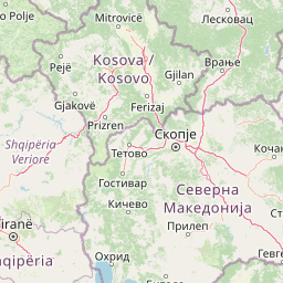
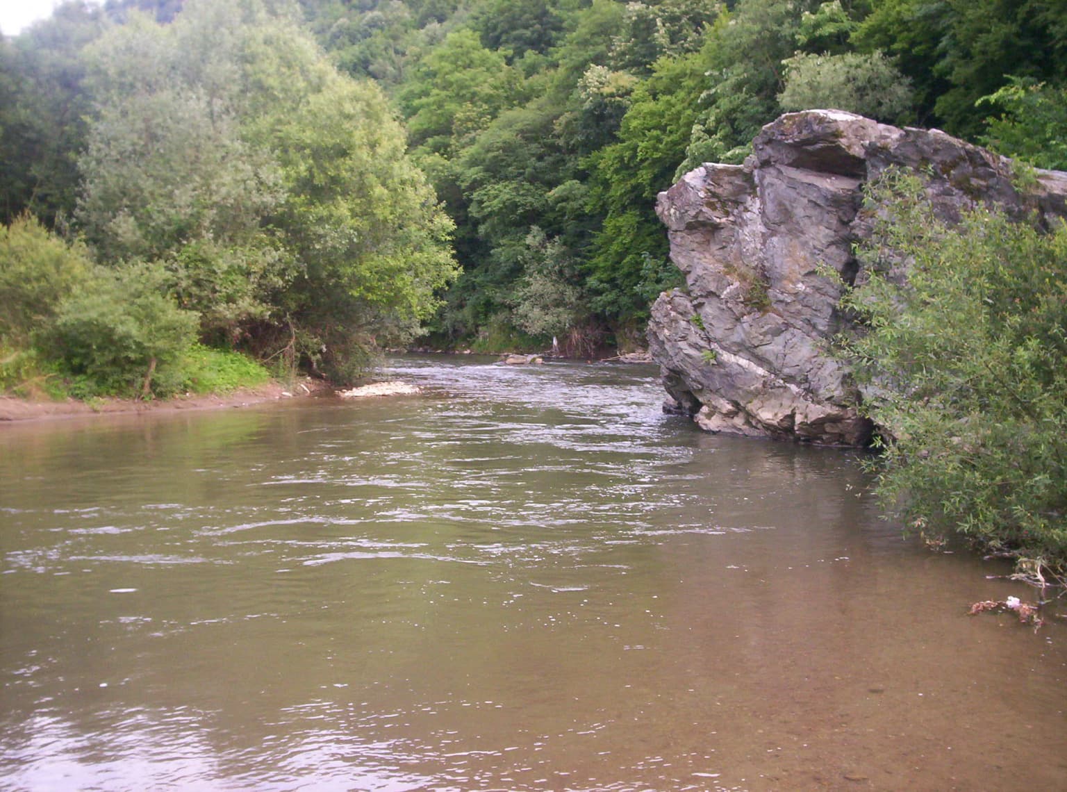
Vlasina Ramsar Wetland landscape and geographic character

The Vlasina Ramsar Wetland landscape is characterized by its high-altitude setting within the Rhodopian mountains of southeastern Serbia. The terrain features mountainous relief with old geological formations, representing some of the region's oldest rocks. The Vlasina River flows through the area, feeding Vlasina Lake, which serves as the central feature of the protected wetland. Near Vlasotince, distinct volcanic remains from ancient eruptions are visible, providing geological interest beyond the wetland's ecological value. The landscape corresponds to a border area with Bulgaria, creating a transitional character between Serbian and Bulgarian terrain. The surrounding region includes smaller valleys and upland areas typical of mountain border landscapes.

Vlasina Ramsar Wetland ecosystems, habitats, and plant life

Vlasina Ramsar Wetland preserves a unique high-altitude freshwater ecosystem within Serbia's protected area network. The wetland environment centered on Vlasina Lake and the Vlasina River provides critical habitat for various species adapted to mountain lake conditions. The ecological character of the area differs significantly from Serbia's lowland wetlands, representing a rare example of elevated wetland ecosystems in the country. The surrounding Rhodopian landscape contributes additional habitat diversity, while the relatively limited human development in the region has helped maintain the wetland's natural ecological processes.

Vlasina Ramsar Wetland wildlife and species highlights

The Vlasina Ramsar Wetland and surrounding region support notable wildlife populations, with scientific discoveries continuing to reveal the area's biodiversity significance. In 2018, researchers announced the discovery of the European free-tailed bat in the Vlasina region, representing the first recorded instance of this species in Serbia. This discovery added the 31st bat species to Serbia's known fauna and identified the European free-tailed bat as the species with the largest wingspan in the country. The presence of this species suggests the area supports important bat populations and likely contains suitable roosting and foraging habitats within its wetland and surrounding environments.

Vlasina Ramsar Wetland conservation status and protection priorities

Vlasina Ramsar Wetland's designation under the Ramsar Convention in 2007 established international protection for this high-altitude wetland ecosystem. The Ramsar status commits Serbia to maintaining the wetland's ecological character and implementing appropriate conservation management. This protected status recognizes the wetland's importance for biodiversity conservation, water resource preservation, and environmental sustainability. The site represents one of Serbia's designated Wetlands of International Importance, contributing to the country's commitments under the Ramsar Convention on wetland conservation.

Vlasina Ramsar Wetland cultural meaning and human context

The Vlasina region encompasses traditional settlement areas within southeastern Serbia's borderland communities. The protected wetland area exists within a landscape shaped by generations of local population, though the region has experienced significant depopulation in recent decades. The municipalities of Crna Trava, Vlasotince, and Surdulica correspond to the Vlasina region's extent, representing areas with historical ties to the land and traditional land-use patterns. The region's relative remoteness and limited economic development have contributed to the preservation of its natural character alongside cultural continuity.

Top sights and standout views in Vlasina Ramsar Wetland

Vlasina Ramsar Wetland stands as Serbia's designated Ramsar site protecting a rare high-altitude mountain lake and river ecosystem in the Rhodopian border region. The wetland's international protection status, combined with significant wildlife discoveries including the European free-tailed bat, underscores its conservation importance. The area's volcanic geological features near Vlasotince, scenic river and lake landscape, and position as one of Serbia's premier mountain wetlands make it a distinctive protected area within the country's conservation network.

Best time to visit Vlasina Ramsar Wetland

The Vlasina Ramsar Wetland can be visited throughout the year, with each season offering different perspectives on the wetland landscape. Summer months typically provide the most accessible conditions for exploring the area's outdoor environments, while the changing seasons reflect the wetland's character within the broader mountain landscape. The high-altitude setting means the region experiences distinct seasonal variations, with winter bringing colder conditions typical of Serbia's mountainous border areas.

Park location guide

Geography guide, regional context, and park location map for Vlasina Ramsar Wetland

Vlasina Ramsar Wetland park geography, regions, and map view in Serbia
Understand where Vlasina Ramsar Wetland sits in Serbia through a broader geographic reading of the surrounding landscape, nearby location context, and its mapped position within the national park landscape.

How Vlasina Ramsar Wetland fits into Serbia

Serbia is a landlocked country in Southeast and Central Europe, bordered by eight neighboring countries. With a population of approximately 6.6 million, it operates as a unitary parliamentary republic with Belgrade as its capital. The country has a rich history dating back to medieval statehood in the 7th century and has been independent since 2006 following the dissolution of Serbia and Montenegro.

Wider geography shaping Vlasina Ramsar Wetland in Serbia

Serbia is a landlocked country in the Balkans, spanning parts of Southeast and Central Europe. It occupies a strategic position in the heart of the Balkan Peninsula, bordered by Hungary to the north, Romania to the northeast, Bulgaria to the southeast, North Macedonia to the south, Croatia to the northwest, Bosnia and Herzegovina to the west, and Montenegro to the southwest. The terrain varies from rolling plains in the north to mountainous regions in the south and east.

Map view of Vlasina Ramsar Wetland

Use this park location map to pinpoint Vlasina Ramsar Wetland in Serbia, understand its exact geographic position, and read its mapped placement within the surrounding landscape more clearly.

Pigeon | © OpenStreetMap contributors

Location context for Vlasina Ramsar Wetland

Crna TravaSurdulicaVlasotince

Explore the distinct scenery, diverse habitats, and ancient geological formations defining Vlasina's unique wetland environment.

Vlasina Protected Area Photos: Discover its Mountain Wetland Landscapes and Scenery
Browse comprehensive Vlasina imagery to visually understand its unique mountain wetland ecosystem and high-altitude setting within the Rhodopian mountains. These protected area photos reveal the scenic Vlasina Lake, river landscapes, and distinct volcanic geological features, offering essential context for its conservation significance and diverse habitats.

River flowing through forested area with large rock formation on right bank

Park atlas

Trace the regional spread of wetlands and mountain protected areas surrounding Vlasina Ramsar Wetland and its unique lake ecosystem.

Discover Protected Areas Near Vlasina: Explore Related Parks and Surrounding Rhodopian Landscapes
Continue your exploration from Vlasina, browsing national parks and protected areas across Serbia and the adjacent Rhodopian mountain border region. Compare diverse protected landscapes, including high-altitude wetlands and mountain ecosystems, to deepen your understanding of regional conservation and varied terrain.
Watercolor illustration of rolling hills and a winding path with green and pink terrain
National park

Stara Planina National Park: Serbia's expansive national park in the Balkan Mountains

Mapped protected landscape and regional geography discovery

Stara Planina National Park is a newly established national park in eastern Serbia, notable for its extensive mountain terrain and designation within the Balkan Mountains. This protected area features the distinctive Kopren plateau, Tupavica waterfall, and rugged landmarks, all contributing to its unique geographic identity. MoriAtlas provides a structured atlas view of Stara Planina National Park, detailing its protected boundaries and landscape context for comprehensive discovery.

Area
1,200 km²
Established
2022
IUCN
II
Relief
Mountain
Watercolor painting depicting a river flowing through rolling hills with green and yellow tones
Protected landscape

Sićevo Gorge Protected Landscape: Explore Serbia's Dramatic Karst Geography

Mapping the unique limestone cliffs and river valley terrain.

Delve into the atlas details of Sićevo Gorge, a protected landscape in Serbia defined by its spectacular limestone cliffs and the Nišava River canyon. This page provides a structured overview of its dramatic topography, intricate karst formations, and the regional geographic context. Understand the mapped boundaries and the unique geological character that makes this gorge a standout feature in Serbia's natural landscape.

IUCN
V
Scope
Terrestrial
Water
Minor water
Watercolor painting of a mountainous landscape with a lake and green fields
National park

Rila National Park: Bulgaria's Largest National Park with Alpine Terrain and Glacial Lakes

Explore mapped boundaries and protected landscape features.

Rila National Park, situated in Bulgaria's Rila mountain range, stands as the country's largest national park and a vital protected landscape. Its territory is characterized by dramatic glacial topography, including the iconic Seven Rila Lakes, and ascends to Musala Peak, the highest summit in the Balkan Peninsula. This atlas entry details the park's extensive mapped boundaries and unique ecosystems, emphasizing its importance for understanding regional geography and protected area networks.

Area
810.46 km²
Established
1992
IUCN
II
Relief
Mountain
Watercolor painting of rolling mountains with green forests and pastel-colored hills
National parkKosovo

Sharr Mountains National Park: Kosovo's Alpine Protected Landscape and Geographic Atlas

Explore its dramatic peaks and glacial terrain.

Sharr Mountains National Park in Kosovo is a prime example of dramatic alpine topography, featuring jagged peaks, steep glacial valleys, and clear evidence of ancient glacial shaping. This protected area safeguards critical ecosystems, including extensive old-growth forests and diverse alpine meadows, supporting notable wildlife conservation efforts. Its scenic ridgelines, glacial lakes, and mountain streams define the park's natural landscape, offering rich context for atlas-based geographic discovery within the Balkans.

IUCN
II
Relief
Mountain
Scope
Terrestrial
Watercolor illustration of mountainous landscape with rolling hills, green fields, and distant snow-capped peaks.
National park

Šar Planina National Park: North Macedonia's Premier Alpine Protected Landscape

Explore glacial lakes, high peaks, and critical Balkan lynx habitat.

Šar Planina National Park is an expansive protected area in North Macedonia, defined by its striking alpine terrain and significant ecological value. The park safeguards a landscape featuring approximately 220 peaks over 2,000 meters and 29 permanent glacial lakes, known as 'Šar's Eyes.' This national park serves as a vital refuge for endangered wildlife, including the Balkan lynx, and offers a unique geographic context for understanding mountain wilderness and protected land distribution in the Balkan region. Its mapped boundaries encompass a rich biodiversity and a landscape shaped by glacial and fluvial processes.

Area
627 km²
Established
2021
IUCN
II
Relief
Mountain
Watercolor illustration of mountainous landscape with forests and distant hills
National park

Kopaonik National Park: Serbia's Premier Protected Mountain Landscape

Explore Balkan biodiversity and unique geographic terrain.

MoriAtlas presents Kopaonik National Park, a key protected area celebrated for its extraordinary endemic plant species and its distinctive mountainous geography. This national park safeguards a significant biodiversity hotspot within the Balkans, characterized by a prominent mountain plateau and peaks exceeding 2,000 meters. Discover the park's varied terrain, from forested slopes to subalpine meadows, and understand its role in regional natural landscapes. Utilize our map-based exploration tools to grasp Kopaonik National Park's protected boundaries and its unique place in geographic context.

Area
118.1 km²
Established
1981
IUCN
II
Relief
Mountain
Watercolor illustration of green mountains and a lake with trees
National parkBlagoevgrad Province

Pirin National Park: Protected Area and Regional Geographic Context in Bulgaria

Explore Pirin National Park's mapped boundaries and landscape.

Pirin National Park serves as a vital national park entity within the atlas of Blagoevgrad Province, Bulgaria. This page details its protected landscape, offering a structured view of its geographic setting and mapped terrain. Users can investigate the park's specific identity and its relation to the surrounding regional geography, providing essential context for understanding protected areas and natural landscapes within a comprehensive map-driven framework.

Area
403.56 km²
Established
1962
IUCN
II
Relief
Mountain
Watercolor painting showing a mountain range with green hills, a lake, and trees in the foreground
National parkLovech Province

Central Balkan National Park: Bulgaria's Majestic National Park and Protected Landscape

Explore mapped alpine terrain and ancient forests in Lovech Province.

Central Balkan National Park is a significant protected area in Bulgaria, renowned for its stunning mountain geography and exceptionally well-preserved ancient beech forests. Located within Lovech Province, the park's landscape is defined by dramatic peaks, including Botev Peak, deep canyons, and alpine meadows, offering a rich context for geographical exploration and understanding its protected status. Its ecosystem health and ecological value are underscored by multiple nature reserves and its recognition as part of a UNESCO World Heritage Site.

Area
716.69 km²
Established
1991
IUCN
II
Relief
Mountain

Common questions about visiting, size, designation, and location context for Vlasina Ramsar Wetland

Vlasina Ramsar Wetland FAQs for park facts, access, geography, and protected area context
Find quick answers about Vlasina Ramsar Wetland, including protected-area facts, park geography, trail and visitor context, and how the park fits into its surrounding country and regional landscape.
MoriAtlas Explorer

Continue Your Protected Areas Search Across the Global Atlas

Deepen your exploration by continuing the structured search for national parks and protected areas worldwide. Utilize the comprehensive filtering capabilities to compare different conservation landscapes and refine your understanding of global park geography. Discover more about the distribution and characteristics of protected natural areas.

Global natural geography