
Wetlands
Park geography
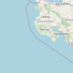
Regional landscape context and environmental mapping for Guanacaste Province
Structured Geographic Profile and Mapped Boundaries of Las Baulas Marine National Park
This geographic profile details the physical scope and environmental characteristics of Las Baulas Marine National Park within Guanacaste Province, Costa Rica. The data encompasses a total area of 175 square kilometers, highlighting the distinct division between terrestrial zones and marine environments alongside major features including beaches, wetlands, and coastal hills.
Related tags
Marine National ParkLeatherback Turtle Nesting SiteRamsar WetlandCosta RicaPacific Coast
Pacific coast leatherback turtle nesting capital and Ramsar-protected marine sanctuary
Las Baulas Marine National Park
Las Baulas Marine National Park is a coastal protected area in Guanacaste Province, Costa Rica, encompassing both terrestrial and marine environments along the Pacific shoreline near the town of Tamarindo. The park covers approximately 7.7 square kilometers of land and 167.3 square kilometers of marine waters within Tamarindo Bay. Established on July 9, 1991, and designated as a Ramsar Wetland site in 1993, the park represents one of the most significant marine conservation areas in Central America. Its sweeping white-sand beaches, coastal forests, mangrove-lined estuaries, and offshore waters create a diverse ecosystem that supports remarkable biodiversity both on land and beneath the waves. The park is administered by the Tempisque Conservation Area under Costa Rica's National System of Conservation Areas.
- Location
- Costa Rica
- Park type
- National park
- Established
- 1991
- Area
- 175 km²
Location overview
Mapped provincial placement and coastal marine status in Guanacaste
Geographic Setting of Las Baulas Marine National Park in Costa Rica
Las Baulas Marine National Park is situated within the Guanacaste Province of Costa Rica. National designations classify the protected area as a coastal and marine territory under single-country jurisdiction.
- Countries
- Costa Rica
- Regions
- Guanacaste Province
- Primary location
- Guanacaste Province
- Geographic setting
- Coastal · Marine
Boundary and coordinates
Mapped protected area geometry and derived spatial measurements
Las Baulas Marine National Park Boundary Map and Spatial Extent
Interactive boundary mapping defines the protected spatial outline and geographic limits for spatial orientation. Associated metrics detail total area proportions, coordinate spans, and center points without claiming legal survey precision.
- Boundary area
- 254.6 km²
- Boundary perimeter
- 96 km
- Northernmost point
- 10.3689° N
- Southernmost point
- 10.2713° N
- Easternmost point
- 85.8215° W
- Westernmost point
- 86.0701° W
- Geographic centre
- 10.3199° N, 85.9526° W
- North–south span
- 10.8 km
- East–west span
- 27.2 km
Terrain and natural features
Explore recorded coastal landforms, beaches, and wetland features.
Las Baulas Marine National Park Terrain and Natural Features
Mixed relief classifications govern the coastal terrain across recorded natural features within the protected boundary. Linked feature cards provide names, types, measurements, and spatial relationships where recorded.
Selected named natural features
Beaches
Playa Carbón
Rivers
Río Tacasolapa
Bays
Bahía Tamarindo
Peninsulas
Nicoya Peninsula
Islands
Isla Capitán
Environmental setting
Interpreting tropical relief, dominant water presence, and seasonal coastal habitats.
Las Baulas Marine National Park Environmental Settings and Mapped Landscape Classifications
Recorded classifications frame the physical setting across coastal, wetland, and forest zones without implying uniform spatial coverage. Connected categories link directly to relevant atlas destinations for structured environmental comparison.
- Relief
- Mixed relief
- Climate
- Tropical
- Water
- Water-dominated
- Forest cover
- Partial forest
- Seasonality
- Strongly seasonal
Landscape features
Coast · Beach · Forest · Wetland · Rivers · Hills
Habitat types
Marine habitat · Wetland · Riverine habitat · Coastal habitat · Tropical forest
Park atlas
Trace the broader protected landscapes and marine environments surrounding Costa Rica's Guanacaste Province.
Discover Nearby National Parks and Protected Areas Beyond Las Baulas Marine National Park
Continue your exploration beyond Las Baulas Marine National Park to browse other national parks and protected areas across Costa Rica's Pacific coast and surrounding regions. Compare varied coastal ecosystems, delve into neighboring terrestrial reserves, and trace the geographic spread of significant conservation landscapes within this diverse atlas view.
National parkGuanacaste Province
26 km away#1 closest
North

Santa Rosa National Park: Guanacaste Province National Park Protected Area
Mapped natural landscape and regional geography.
Santa Rosa National Park is a vital protected area within Costa Rica's Guanacaste Province. This detail page offers an atlas-focused view of the park, highlighting its geographic setting and mapped boundaries. It serves as a primary resource for understanding the park's protected landscape identity and its contribution to regional conservation geography, supporting structured exploration for users interested in natural areas.
- Area
- 815.31 km²
- Established
- 1966
- IUCN
- II
- Climate
- Tropical
National parkGuanacaste Province
About 29 km away#2 closest
Southeast
Diriá National Park: Protected Landscape Atlas within Guanacaste Province
National Park geographic context and mapped terrain.
Examine Diriá National Park as a distinct protected area within Guanacaste Province. This detailed entry focuses on its geographic identity, mapped boundaries, and natural landscape characteristics. Understand how this national park contributes to the regional atlas, offering a clear view of its protected status and natural terrain features for focused discovery.
- Area
- 28 km²
- Established
- 1991
- IUCN
- II
- Relief
- Mountain
National parkCosta Rica
45 km away#3 closest
East
Palo Verde National Park: Costa Rica's Protected Landscape Geography and Map Context
Explore mapped park boundaries and regional natural landscapes.
Delve into the geographic identity of Palo Verde National Park, a protected area within Costa Rica. This detail entry focuses on its mapped landscape, providing context for its protected boundaries and regional setting. Understand how Palo Verde National Park fits into the broader atlas of Costa Rican geography, offering a factual basis for exploring its specific natural terrain and its significance as a national park within Central America's rich biodiversity.
- Area
- 184 km²
- Established
- 1978
- IUCN
- II
- Relief
- Lowland
National parkCosta Rica
52 km away#4 closest
East
Barra Honda National Park: Costa Rican Protected Landscape and Geographic Atlas
Mapped boundaries and regional park geography.
Barra Honda National Park stands as a notable protected area, offering a distinct geographic profile within Costa Rica. Its designation as a national park underscores its importance for landscape conservation and atlas exploration. This entry details the park's mapped terrain and its contribution to understanding the regional geography, providing a focused view for those interested in protected land distribution and natural context.
- Area
- 23 km²
- Established
- 1974
- IUCN
- II
- Relief
- Mountain
National parkGuanacaste Province
61 km away#5 closest
Northeast
Guanacaste National Park: A Protected Landscape within Guanacaste Province's Geography
Explore mapped park boundaries and regional natural landscape context.
Delve into the protected landscape of Guanacaste National Park, a significant national park located within Guanacaste Province. This entry provides a focused view of its geographic features, mapped protected areas, and its role within the regional terrain. Understand the park's specific natural landscape character and its placement in the broader atlas of conservation lands.
- Area
- 340 km²
- Established
- 1991
- IUCN
- II
- Relief
- Mixed relief
National parkGuanacaste Province
About 82 km away#6 closest
Northeast
Rincón de la Vieja National Park: Costa Rican National Park Atlas Entry
Mapped protected landscape and regional geography.
Gain a structured understanding of Rincón de la Vieja National Park as a key protected area within Guanacaste Province. This detail page offers an atlas-focused perspective, highlighting its mapped boundaries and regional geographic significance. Explore how this national park contributes to the protected landscapes of Costa Rica, providing essential context for geographic discovery.
- Area
- 141.61 km²
- Established
- 1973
- IUCN
- II
- Climate
- Tropical
National parkCosta Rica
83 km away#7 closest
Northeast
Miravalles Jorge Manuel Dengo National Park: Costa Rica National Park Geographic Context
Mapped protected landscape and regional park geography.
Miravalles Jorge Manuel Dengo National Park offers a focused lens for understanding protected natural areas within Costa Rica. Explore its specific geographic footprint and the surrounding regional context to appreciate its significance as a mapped protected landscape. This detailed view supports a structured discovery of the park's identity, helping users grasp its place within the national atlas.
- Area
- 43 km²
- Established
- 2019
- IUCN
- II
- Relief
- Mountain
National parkCosta Rica
92 km away#8 closest
East
Tenorio Volcano National Park: National Park Geographic Context in Costa Rica
Map exploration of its volcanic terrain and protected area boundaries.
Delve into Tenorio Volcano National Park, a key national park entity situated within Costa Rica's vibrant geography. This page provides detailed atlas-style information, focusing on the park's mapped boundaries, its characteristic volcanic landscape, and its role in understanding the broader distribution of protected areas across the country. Understand the park's specific geographic identity and its contribution to the nation's natural heritage.
- Area
- 129 km²
- Established
- 1976
- IUCN
- II
- Relief
- Mountain
MoriAtlas Explorer
Continue exploring Las Baulas Marine National Park's geographic and protected landscape identity
Deepen your understanding of Las Baulas Marine National Park by delving into its specific mapped boundaries and its role within the regional geography of Guanacaste Province. This national park offers a distinct perspective on protected land context and atlas-driven exploration, providing valuable insights for understanding natural landscapes across Costa Rica.
Browse next
Global natural geography
Explore related park routes
Explore MoriAtlas Global ParksBrowse All MoriAtlas ParksGlobal Park Map DiscoveryMoriAtlas: Browse All CountriesBrowse All MoriAtlas ContinentsNational Park Environment AtlasGrand Canyon National Park AtlasYellowstone National Park AtlasYosemite National Park Atlas and GeographySerengeti National Park AtlasGalápagos National Park Protected LandscapeBanff National Park Geography and AtlasKruger National Park Atlas EntryUluṟu-Kata Tjuṯa National Park AtlasExplore Uluru-Kata Tjuta National Park GeographyPlitvice Lakes National Park AtlasFiordland National Park Protected LandscapeGreat Smoky Mountains National Park AtlasAfghanistan National Parks and Protected AreasAlbania National Parks and Protected AreasAlgeria National Parks and Protected AreasAmerican Samoa National Parks and Protected AreasAndorra National Parks and Protected AreasAngola National Parks and Protected AreasAntarctica National Parks and Protected AreasAntigua and Barbuda Park List