Mori Atlas logo
National parkLos Cardones National Park

Discover the mapped boundaries and regional terrain of this key national park entity.

Los Cardones National Park: Protected Landscape and Geographic Context in Salta Province

(Parque y Reserva Nacional Los Cardones)

Los Cardones National Park stands as a significant protected area within Argentina's Salta Province. This page offers an atlas-style exploration of the park's national park designation, detailing its mapped boundaries and its place within the regional geography. Users can gain structured insights into the park's landscape context and its role as a protected natural entity.

National ParkArgentinaAndes MountainsCactus ForestsSalta ProvinceHigh Desert

Los Cardones National Park

National park

Park overview

Structured park overview, official facts, and landscape profile for Los Cardones National Park

Los Cardones National Park park facts, protected area profile, and essential visitor context
Review the core facts for Los Cardones National Park, including designation, size, terrain, visitor scale, habitats, and operating context in one park-focused overview.

About Los Cardones National Park

Los Cardones National Park protects a remarkable transect of Andean ecosystems in northwestern Argentina, representing one of the most ecologically diverse protected areas in the Salta province. The park's landscape is characterized by dramatic relief including steep mountain slopes, gentle piedemonte surfaces, and endorheic basins that create a complex topographic mosaic. The vegetation reflects this environmental diversity, with cardon cactus dominating the lower zones while churqui (Prosopis ferox) woodlands occur at higher elevations, and alpine grasslands appear in the puna and altoandina zones. The park serves as a critical corridor for wildlife movement through the fragmented agricultural landscape of the Calchaquíes valleys, providing refuge for species including guanacos, Andean foxes, and the rare pajonal cat. Beyond its ecological significance, the park contains evidence of human presence dating to pre-Hispanic times, when pastoralists utilized the area's water sources and grasslands for livestock husbandry. The park remains an active research site for paleontologists studying Cretaceous dinosaur fauna and for botanists documenting the unique cactus diversity of the southern Bolivian and northwestern Argentine inter-Andean basins.

Quick facts and research context for Los Cardones National Park

Los Cardones National Park is located in Salta Province, Argentina, approximately 100 kilometers from the city of Salta near the town of Payogasta. The protected area was established in 1996 through Law 24737 and covers roughly 64,000 hectares within the Argentine Northwest region. The park features an arid climate with large temperature fluctuations between day and night, receiving approximately 150-200mm of annual rainfall concentrated between November and March. Mean temperatures range from 11°C in winter to 18°C in summer. The park is administered by Argentina's Administración de Parques Nacionales and is classified as an IUCN Category II protected area.

Park context

Deeper park guide and search-rich context for Los Cardones National Park

Los Cardones National Park history, landscape, wildlife, and travel context
Explore Los Cardones National Park through its history, landscape character, ecosystems, wildlife, conservation priorities, cultural context, and seasonal travel timing in a structured park guide built for atlas discovery and search intent.

Why Los Cardones National Park stands out

Los Cardones National Park is best known for its extraordinary stands of cardon grande cactus, which form distinctive forest-like formations across the Andean desert landscape. The park preserves one of the most significant paleontological sites in northern Argentina, featuring well-preserved dinosaur tracks estimated at 70 million years old that attract scientific interest. Its location along provincial Route 33, including the famous Recta del Tin-Tin straight road section, provides accessible exploration of a fragile high-altitude desert ecosystem that transitions through multiple phytogeographic zones from Monte through Prepuna to Puna and Altoandina environments.

Los Cardones National Park history and protected-area timeline

The creation of Los Cardones National Park resulted from over a decade of planning that began in 1986 when the province of Salta and the Administración de Parques Nacionales signed a cooperation agreement to establish the protected area. The formal creation project was outlined in 1988 with multiple objectives including protection of representative flora and fauna of Andean biomes, conservation of the altitudinal gradient and its ecological processes, protection of singular features such as churqui forest and wetlands, and preservation of pre-Hispanic cultural heritage. The province of Salta ceded jurisdiction through Provincial Law 6805 in August 1995, transferring approximately 70,690 hectares to the national government. National Law 24737, passed on November 20, 1996, formally accepted the jurisdiction transfer and established the legal framework for the park and national reserve. At the time of creation, 116 people lived within the park boundaries in 31 family groups engaged primarily in livestock grazing. A 2007 census showed this population had decreased to 98 people in 25 families, who continue to use between 33% and 50% of the park area for grazing. The park's Management Plan was most recently updated in November 2017, establishing detailed zoning for the national park and reserve sections.

Los Cardones National Park landscape and geographic character

The landscape of Los Cardones National Park encompasses three primary geomorphological environments that create its distinctive character. The serrano environment features pronounced relief with steep mountain ranges and isolated peaks including Cerro Negro (Malcante) reaching 5,226 meters. The piedemonte and bajadas present gently sloping surfaces preserved from active fluvial deposition, alongside areas subject to ongoing erosion and sediment accumulation. The depressions correspond to low-lying areas receiving continuous fine material transport from water flow. The park's most visually striking feature is the extensive cardon cactus formations that create a forest-like appearance across the valleys and lower slopes. These towering columnar cacti, reaching heights of several meters, define the park's visual identity and provide critical habitat for numerous species. The landscape also features the Valley Encantado, a notable scenic location with an overlook and parking area, and is traversed by the Recta del Tin-Tin, a perfectly straight section of Provincial Route 33 that connects the Lerma Valley with the Calchaquíes valleys.

Los Cardones National Park ecosystems, habitats, and plant life

The ecological character of Los Cardones National Park is defined by its position at the intersection of multiple phytogeographic provinces, creating exceptional biodiversity within a relatively compact area. The Prepuneña province dominates the lower elevations, characterized by the iconic cardon cactus formations. The Monte de Sierras y Bolsones district appears in transitional areas, while the Puneña and Altoandino Quechua provinces occur at higher elevations. The park contains important churqui (Prosopis ferox) woodlands at higher altitudes, representing a distinct habitat type within the protected area. Wetlands and endorheic basins support specialized hydrophilic vegetation communities despite the overall arid conditions. The cactus diversity is particularly noteworthy, with numerous species including the small-spined Echinopsis cinnabarina occurring within the park boundaries. The altitudinal gradient from approximately 2,600 meters to over 5,200 meters creates a complex mosaic of habitats that supports species adapted to different elevation zones.

Los Cardones National Park wildlife and species highlights

The wildlife community of Los Cardones National Park reflects the park's position in the Andean desert environment, with several species of conservation concern present in the area. The guanaco (Lama guanicoe) remains the most commonly observed large mammal, often seen grazing in the open terrain. Two fox species occur in the park: the culpeo or red fox (Lycalopex culpaeus) and the grey or pampas fox (Lycalopex gymnocercus). The rare pajonal cat (Leopardus garleppi), also known as the Andean mountain cat, represents one of the most threatened felines in South America and has been recorded in the park. Other mammals include the chinchillón (Lagidium viscacia) and the piche or hairy armadillo (Chaetophractus vellerosus). The park has been designated as an Important Bird Area (IBA) due to its significant avian diversity, supporting numerous species including the rufous-banded miner, straight-billed earthcreeper, chestnut-winged cinclodes, and various canastero species. The bird community includes both resident and migratory species adapted to the high-altitude desert environment.

Los Cardones National Park conservation status and protection priorities

Los Cardones National Park plays a crucial role in protecting the biodiversity of northwestern Argentina's Andean environments, which face significant pressures from mining, grazing, and infrastructure development. The park's zoning system divides the protected area into zones with different allowed uses, with a substantial intangible zone covering over 30,000 hectares that protects the most ecologically sensitive areas including altoandine and puneño communities, wetlands, and critical wildlife habitat. A subzone for recovery of intangibility encompasses areas currently used for grazing that are targeted for reduced human impact over time. The park's designation as an Important Bird Area recognizes its global significance for avian conservation. The presence of threatened species including the pajonal cat and guanaco adds to the conservation importance of the area. The park's management plan addresses the ongoing challenge of balancing traditional grazing activities by local communities with the need to protect the fragile desert ecosystem.

Los Cardones National Park cultural meaning and human context

The area now within Los Cardones National Park held significance for pre-Hispanic cultures, who recognized the strategic value of its water sources and high-altitude grasslands for pastoral activities. The park contains archaeological evidence of human presence including rock art (pinturas rupestres) that attests to the historical importance of this landscape. Local communities, particularly in the southern portion of the park, maintain traditional livelihoods centered on livestock grazing, with residents continuing to use portions of the protected area for their animals. The park is accessed via Provincial Route 33, which follows historic pathways connecting the Lerma Valley with the Calchaquíes valleys, a route of cultural and commercial significance dating to colonial times. The town of Payogasta, located near the park's administrative center, serves as a gateway community for visitors exploring this corner of Salta Province.

Top sights and standout views in Los Cardones National Park

Los Cardones National Park offers visitors the opportunity to explore one of Argentina's most distinctive cactus-dominated landscapes, with the towering cardon grande forming forest-like stands across the Andean foothills. The dinosaur track sites represent a unique paleontological attraction, with 70-million-year-old footprints preserved in the desert substrate. Several viewpoints including Ojo de Cóndor and Secretos del Cardonal provide access to scenic panoramas of the mountain and valley terrain. The park's location along the Recta del Tin-Tin makes it accessible from Salta for day trips, though overnight visitors should note limited infrastructure within the protected area. Hiking trails range from short overlooks to longer routes through the mountain terrain, with the Valley Encantado area offering one of the most developed visitor facilities.

Best time to visit Los Cardones National Park

The optimal time to visit Los Cardones National Park corresponds to the dry season from April through October, when clear skies predominate and daytime temperatures remain comfortable for outdoor exploration. Winter months (June through August) offer the clearest visibility and most stable weather, though nights can be cold at higher elevations. The summer rainy season from November through March brings intermittent storms that can create muddy trail conditions and reduce visibility in the mountains, though this period also brings the greenest vegetation and best cactus flowering. The park can be visited year-round, but the shoulder seasons of spring (September-November) and autumn (March-May) often provide the best balance of favorable weather and accessible conditions. Visitors should be prepared for large temperature swings between day and night in all seasons, typical of high-altitude desert environments.

Park location guide

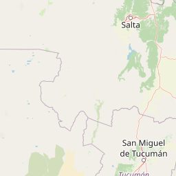
Geography guide, regional context, and park location map for Los Cardones National Park

Los Cardones National Park park geography, regions, and map view in Argentina
Understand where Los Cardones National Park sits in Argentina through a broader geographic reading of the surrounding landscape, nearby location context, and its mapped position within the national park landscape.

How Los Cardones National Park fits into Argentina

Argentina is a federal republic located in the southern cone of South America, bordering Chile, Bolivia, Paraguay, Brazil, Uruguay, and the Atlantic Ocean. With an area of 2,780,085 km², it is the second-largest country in South America and the eighth-largest globally. The capital and largest city is Buenos Aires, and the official language is Spanish. The country claims sovereignty over the Falkland Islands, South Georgia and the South Sandwich Islands, and a portion of Antarctica.

Wider geography shaping Los Cardones National Park in Argentina

Argentina occupies the southern portion of South America, sharing the Southern Cone region with Chile to the west. The country borders Bolivia and Paraguay to the north, Brazil to the northeast, Uruguay and the South Atlantic Ocean to the east, and the Drake Passage to the south. The Andes mountain range runs along the western border, while the Pampas plains dominate the central region. Argentina also claims territories in Antarctica.

Map view of Los Cardones National Park

Use this park location map to pinpoint Los Cardones National Park in Argentina, understand its exact geographic position, and read its mapped placement within the surrounding landscape more clearly.

Pigeon | © OpenStreetMap contributors

Location context for Los Cardones National Park

Salta Province
Park atlas

Compare diverse protected landscapes, high desert ecosystems, and Andean foothills across Argentina's Salta Province.

Discover Other National Parks and Protected Areas Near Los Cardones National Park
Browse national parks and protected areas geographically connected to Los Cardones National Park, exploring the high-altitude desert ecosystems and unique cactus forests of northwestern Argentina. Compare these diverse conservation landscapes to understand regional protected area spread and similar Andean mountain environments within Salta Province.
National parkSalta Province

El Rey National Park: Protected Landscape and Geographic Atlas Exploration

Mapped boundaries and regional context within Salta Province.

Gain insight into El Rey National Park, a designated national park offering a distinct protected landscape within Argentina. This entry focuses on its mapped geographic presence and its role in the regional context of Salta Province. Understanding El Rey National Park through its terrain and protected status provides a foundational element for exploring South American natural areas within a structured atlas framework.

Area
441.62 km²
IUCN
II
Relief
Mountain
Scope
Terrestrial
National parkTucumán Province

Aconquija National Park: Southern Andean Yungas Protected Landscape in Tucumán Province

Explore its montane forest and mapped geographic context.

Aconquija National Park is a significant federal protected area located in Tucumán Province, Argentina. This national park is dedicated to conserving the diverse Southern Andean Yungas montane forest ecosystem, characterized by a dramatic elevational gradient. Its landscapes transition from cloud forest to high alpine terrain, offering a unique opportunity to study and appreciate a well-preserved montane environment within a critical geographic region. Discover the mapped extent and ecological importance of this protected area.

Area
700 km²
Established
1995
IUCN
II
Relief
Mountain
National parkAntofagasta Region

Llullaillaco National Park: Mapped Volcanic Terrain and Protected Andean Landscape

Explore the high-altitude desert ecosystem and national park boundaries.

Llullaillaco National Park is a significant protected area in the Antofagasta Region, characterized by its striking volcanic landscape and high-altitude desert environment. The park's geography includes the towering Llullaillaco volcano, ancient ravines, and expansive semi-desert plains, forming a unique segment of the Central Andean dry puna ecoregion. Discover the mapped terrain and protected area context of this remarkable Chilean national park, offering insights into its arid-adapted biodiversity and geological significance.

Area
2,687 km²
IUCN
II
Relief
Mountain
Climate
Arid
National parkArgentina

Baritú National Park National Park: Mapped Protected Landscapes in Argentina's Geography

Understand the natural terrain and geographic setting of this Argentinian park.

Baritú National Park represents a distinct national park entity within Argentina, crucial for understanding the country's protected landscapes and regional geography. This page provides specific atlas-level detail on its mapped boundaries and the surrounding natural terrain. Explore Baritú National Park as a key geographic feature contributing to the broader understanding of conservation areas across South America, grounded in factual, map-oriented discovery.

Area
720 km²
Established
1974
IUCN
II
Relief
Mountain
National parkAtacama Region

Nevado Tres Cruces National Park: National Park in Atacama Region's Mapped Geography

Explore protected landscapes and regional park context.

Nevado Tres Cruces National Park is a significant protected national park situated within the Atacama Region of Chile. This entry provides essential geographic context, detailing the park's mapped boundaries and its contribution to the region's conservation landscape. Understand its place within the broader atlas of protected areas, focusing on the natural terrain and the distinct geography that characterize this important national park.

Area
591 km²
IUCN
II
Relief
Mountain
Climate
Alpine
National parkSantiago del Estero Province

Copo National Park: A Vital Dry Chaco Protected Landscape in Argentina

Explore its mapped boundaries and endemic forest ecosystems.

Copo National Park represents a significant conservation effort within Santiago del Estero Province, protecting a representative segment of the Dry Chaco biome. This national park preserves the iconic quebracho scrubland, a habitat that has been drastically reduced province-wide, serving as a critical refuge for endangered species like the jaguar and maned wolf. The park's landscape features warm climate conditions and characteristic forest formations dominated by the Santiago red quebracho, offering a unique opportunity to study and appreciate a vital, yet vulnerable, regional ecosystem. Its protected status underscores its importance for understanding Argentine protected areas and landscape ecology.

Area
1,181.18 km²
Established
2000
IUCN
II
Relief
Lowland
National parkChile

Pan de Azúcar National Park: Chile's Protected Natural Landscape and Atlas Context

Discover mapped boundaries and regional geography for this national park.

Pan de Azúcar National Park is a protected area situated within Chile's diverse geography. This page provides detailed information on its status as a national park, focusing on its mapped boundaries and its contribution to the regional landscape context. Users can explore its geographic significance and understand its place within the broader atlas of protected areas.

Area
437.54 km²
Established
1985
IUCN
II
Relief
Mixed relief
National parkAntofagasta Region

Morro Moreno National Park National Park: Mapped Landscape and Regional Geography in Antofagasta

Explore its protected boundaries and arid terrain.

Morro Moreno National Park represents a vital protected area within the northern Chilean landscape of the Antofagasta Region. This national park serves as a focal point for understanding the specific geography and mapped terrain characteristic of this arid zone. By examining Morro Moreno National Park, users gain insight into the distribution of protected lands and the unique natural context it provides for regional geographic study.

Area
73.14 km²
Established
2010
IUCN
II
Relief
Upland

Common questions about visiting, size, designation, and location context for Los Cardones National Park

Los Cardones National Park FAQs for park facts, access, geography, and protected area context
Find quick answers about Los Cardones National Park, including protected-area facts, park geography, trail and visitor context, and how the park fits into its surrounding country and regional landscape.
MoriAtlas Explorer

Continue Your Protected Areas Search Across the Global Atlas

Deepen your exploration by continuing the structured search for national parks and protected areas worldwide. Utilize the comprehensive filtering capabilities to compare different conservation landscapes and refine your understanding of global park geography. Discover more about the distribution and characteristics of protected natural areas.

Global natural geography