

Mori Atlas logo
National parkMayumba National Park

Trace the mapped boundaries and regional geography of this significant protected area in Central Africa.

Mayumba National Park: Gabon's Protected National Park Landscape and Geographic Context

Mayumba National Park represents a vital protected landscape within Gabon, contributing to the nation's network of conservation areas. This page focuses on the park's specific geography, allowing for detailed exploration of its mapped boundaries and its place within the broader regional context of Central Africa. Understand the unique landscape characteristics and the atlas-scale significance of Mayumba National Park.

Marine Protected AreaLeatherback Turtle Nesting SiteCoastal EcosystemForest Elephant HabitatGorilla ConservationMigratory Whale Habitat

Mayumba National Park

National park

Park overview

Structured park overview, official facts, and landscape profile for Mayumba National Park

Mayumba National Park park facts, protected area profile, and essential visitor context
Review the core facts for Mayumba National Park, including designation, size, terrain, visitor scale, habitats, and operating context in one park-focused overview.

About Mayumba National Park

Mayumba National Park occupies a distinctive geographic position in southern Gabon, forming a narrow coastal corridor that stretches along the Atlantic Ocean between the town of Mayumba and the border with the Republic of Congo. This positioning gives the park its remarkable character as a transition zone between Central African rainforest systems and the Atlantic coast. The park's establishment in 2002 reflected Gabon's commitment to protecting its coastal biodiversity, and its design intentionally included marine waters extending 15 kilometers offshore, a rarity among African national parks that typically focus on terrestrial environments. This marine component proves essential for protecting the complete life cycle of species like the leatherback turtle, which depends on both beach nesting sites and offshore marine habitats. The park's terrain varies from sandy beaches and coastal dunes to more interior savanna and forest zones, creating a mosaic of habitats that supports remarkable biological diversity. Management by the National Agency for National Parks oversees both conservation protection and the limited sustainable use opportunities that support local communities while maintaining ecological integrity.

Quick facts and research context for Mayumba National Park

Mayumba National Park is situated in southwestern Gabon near the town of Mayumba, approximately 870 square kilometers in extent, established in 2002 under management by Gabon's National Agency for National Parks. The park is unique in Gabon for its dual terrestrial-marine character, protecting 15 kilometers of offshore marine habitat in addition to its coastal strip. Its 60 kilometers of beaches represent the most important leatherback turtle nesting site globally. The park's diverse habitats include beach, coastal dunes, savanna, and tropical rainforest, supporting populations of forest elephants, buffaloes, leopards, gorillas, chimpanzees, hippos, crocodiles, and various monkey species. Marine visitors include dolphins, sharks, and seasonal humpback whales.

Park context

Deeper park guide and search-rich context for Mayumba National Park

Mayumba National Park history, landscape, wildlife, and travel context
Explore Mayumba National Park through its history, landscape character, ecosystems, wildlife, conservation priorities, cultural context, and seasonal travel timing in a structured park guide built for atlas discovery and search intent.

Why Mayumba National Park stands out

Mayumba National Park is globally renowned for its exceptional leatherback turtle nesting beaches, which represent the most significant reproductive habitat for this endangered marine reptile on Earth. The park's 60 kilometers of protected coastline provide critical nesting grounds that support the survival of leatherback populations threatened by poaching, coastal development, and climate change. Beyond this superlative conservation significance, the park stands out for its unique status as Gabon's only primarily marine national park, offering protection to coastal waters that host dolphins, sharks, and migrating humpback whales. The seamless integration of terrestrial and marine protected zones creates an unusually comprehensive coastal ecosystem that includes beach, dune, savanna, and rainforest habitats within a single park boundary.

Mayumba National Park history and protected-area timeline

Mayumba National Park was established in 2002 as part of Gabon's expanding network of protected areas under the country's national park system. The creation of the park reflected growing recognition of the global significance of Gabon's coastal ecosystems, particularly the critical leatherback turtle nesting beaches that had faced increasing pressure from human activities. Prior to formal protection, the coastline served as a nesting ground for leatherback turtles that had been subjected to egg harvesting and habitat disturbance. The park's designation as Gabon's first primarily marine national park represented an innovative approach to conservation in Central Africa, acknowledging that effective protection for migratory marine species required extending boundaries beyond the traditional terrestrial focus. Management responsibility was assigned to the National Agency for National Parks, which coordinates protection efforts with international conservation partners including the Wildlife Conservation Society. The park's establishment also acknowledged the importance of the region's biodiversity beyond the turtles, recognizing the interconnected nature of coastal forests, savannas, and marine waters that together form a functional ecosystem.

Mayumba National Park landscape and geographic character

The landscape of Mayumba National Park presents a dramatic transition from ocean to interior, with a distinctive coastal character shaped by the Atlantic shoreline. The park's beaches span approximately 60 kilometers of relatively undeveloped coastline, featuring wide sandy stretches that serve as critical nesting habitat for leatherback turtles. Behind the beaches, coastal dunes provide additional topographic variation and habitat diversity. Moving inland, the terrain transitions through savanna zones characterized by grasslands with scattered trees, before giving way to tropical rainforest in the more interior sections. This gradient from beach through savanna to forest creates a remarkably diverse landscape within a relatively narrow corridor. The park also extends offshore, protecting marine waters and the submerged coastal platform that supports marine ecosystems distinct from the terrestrial environments. This combination of coastal, dune, savanna, forest, and marine environments within a single protected area makes Mayumba exceptional among Central African parks, offering a comprehensive representation of coastal ecosystem types.

Mayumba National Park ecosystems, habitats, and plant life

The ecological character of Mayumba National Park reflects its position at the intersection of multiple habitat types, creating unusual biodiversity richness within a coastal setting. The park's beaches and adjacent marine waters support one of the most important leatherback turtle nesting populations in the world, with the protected coastline providing essential reproductive habitat for this endangered species. The marine zone extending 15 kilometers offshore protects feeding grounds and migratory corridors for dolphins, sharks, and seasonal humpback whales that traverse these coastal waters. On land, the savanna and forest habitats support a diverse mammal community including forest elephants, buffaloes, leopards, gorillas, and chimpanzees. The transitional nature of the park, where rainforest meets savanna and coast, creates ecological niches that support species adapted to multiple habitat types. This diversity of terrestrial and marine habitats within a single protected area makes Mayumba particularly valuable for conservation, as it protects complete ecosystem processes rather than isolated habitats.

Mayumba National Park wildlife and species highlights

Mayumba National Park supports an impressive array of wildlife across its terrestrial and marine environments, reflecting the diversity of habitats contained within its boundaries. The park's terrestrial mammal community includes forest elephants, the smaller forest-dwelling relative of savanna elephants, as well as buffaloes, leopards, gorillas, and chimpanzees that represent some of Africa's most iconic large mammals. Antelopes and various monkey species add to the mammalian diversity, while crocodiles and hippos occupy aquatic habitats in the park's waterways. The marine environment hosts dolphins and sharks that utilize the coastal waters, along with seasonal humpback whales that migrate through these offshore areas. Most critically, the park protects the world's most important leatherback turtle nesting beaches, where females come ashore to lay their eggs in the sandy shores. This convergence of terrestrial and marine wildlife within a single protected area creates exceptional biodiversity value, supporting both forest-dwelling species in the interior and marine species in the coastal waters.

Mayumba National Park conservation status and protection priorities

Mayumba National Park holds exceptional conservation significance as the site of the world's most important leatherback turtle nesting beaches, a status that elevates its importance beyond regional to global conservation priority. The approximately 60 kilometers of protected coastline provide critical reproductive habitat for leatherback turtles, which have suffered severe population declines across their global range due to egg harvesting, fisheries bycatch, coastal development, and plastic pollution. Protecting these nesting beaches is essential for the species' survival, making Mayumba a key site for marine reptile conservation. The park's designation as Gabon's only primarily marine national Park demonstrates an innovative approach to conservation that acknowledges the interconnectedness of coastal and marine ecosystems. The dual terrestrial-marine protection ensures that the full lifecycle of migratory species like turtles, dolphins, and whales receives comprehensive safeguarding. Conservation challenges include managing human-wildlife conflict, preventing poaching of turtle eggs, and addressing the broader threats of climate change and ocean pollution that affect even protected marine environments.

Mayumba National Park cultural meaning and human context

Mayumba National Park takes its name from the nearby town of Mayumba, a small coastal settlement that represents the human presence within this largely wilderness region of southern Gabon. The park's location near the border with the Republic of Congo places it at the intersection of different regional communities and cultural traditions. Traditional fishing communities along the coast have historically utilized marine resources, and the park's management must balance conservation objectives with the sustainable livelihoods of local populations. The broader region of southern Gabon has relatively low population density compared to the interior, which has allowed the coastal ecosystems to retain more natural character than in heavily populated areas. Understanding the cultural context of the region helps explain why these beaches remained relatively undeveloped and available for turtle nesting, even as other coastal areas elsewhere in Africa experienced intensive human modification.

Top sights and standout views in Mayumba National Park

The defining highlight of Mayumba National Park is its status as the world's most critical leatherback turtle nesting site, with 60 kilometers of protected beaches supporting one of the largest remaining populations of this endangered species. The park's unique distinction as Gabon's only primarily marine national park, extending 15 kilometers offshore, sets it apart in African conservation and provides comprehensive protection for coastal and oceanic species. The extraordinary concentration of diverse habitats within a relatively compact area beach, dunes, savanna, rainforest, and marine environments creates exceptional ecological richness. The presence of major wildlife species including forest elephants, gorillas, chimpanzees, leopards, and hippos adds to the park's conservation value, while the marine mammals such as dolphins and migrating humpback whales demonstrate the park's importance beyond its terrestrial borders.

Best time to visit Mayumba National Park

The optimal time to experience Mayumba National Park relates primarily to wildlife viewing opportunities and seasonal conditions. The dry season from May to September typically offers easier access to interior areas and more comfortable conditions for wildlife observation. For leatherback turtle nesting, the peak season generally occurs from October through March when females come ashore to deposit their eggs in the sandy beaches, offering remarkable opportunities to witness this ancient reproductive journey. Humpback whales migrate through the offshore waters typically between July and November, making this period particularly special for marine wildlife viewing. The wet season from October to May brings higher rainfall that can affect accessibility but also supports the lush green landscapes that characterize the park's interior. Visitors should note that park access may be influenced by weather conditions and that advance planning with park authorities is advisable given the remote nature of this coastal protected area.
Park location guide

Geography guide, regional context, and park location map for Mayumba National Park

Mayumba National Park park geography, regions, and map view in Gabon
Understand where Mayumba National Park sits in Gabon through a broader geographic reading of the surrounding landscape, nearby location context, and its mapped position within the national park landscape.

How Mayumba National Park fits into Gabon

Gabon is a Central African country on the Atlantic coast, positioned on the equator. It gained independence from France in 1960 and is governed as a unitary presidential republic. The country has significant oil wealth and one of the highest Human Development Index rankings in Africa, though wealth distribution remains uneven.

Wider geography shaping Mayumba National Park in Gabon

Gabon is situated on the Atlantic coast of Central Africa, positioned along the equator. It borders Equatorial Guinea to the northwest, Cameroon to the north, and the Republic of the Congo to the east and south. The terrain includes coastal plains along the Atlantic, mountain ranges in the center (the Cristal Mountains and Chaillu Massif), and savanna zones in the east.

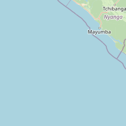
Map view of Mayumba National Park

Use this park location map to pinpoint Mayumba National Park in Gabon, understand its exact geographic position, and read its mapped placement within the surrounding landscape more clearly.

Pigeon | © OpenStreetMap contributors
Park atlas

Compare the diverse marine and terrestrial national parks and protected landscapes across Gabon and the wider Central African coast.

Explore Other Protected Areas Near Mayumba National Park, Gabon's Coastal and Forest Landscapes
After exploring Mayumba National Park's unique coastal ecosystems and leatherback turtle nesting beaches, browse nearby national parks and protected areas to understand regional conservation efforts. Compare their varied landscapes, from marine zones and coastal dunes to inland rainforests, offering a broader geographic perspective on Gabon's rich biodiversity.
Watercolor painting showing a river with green hills and pink flowers in the foreground
National parkKouilou Department

Conkouati-Douli National Park: Mapping Protected Landscape Boundaries and Regional Geography

Explore its national park status and geographic context.

Conkouati-Douli National Park is a protected area situated in the Kouilou Department, offering a focused point for geographic and landscape discovery. This detail provides an atlas-style perspective on its mapped boundaries and its contribution to the regional geography. Understand the park as a distinct natural landscape and a key component of conservation within its geographic setting.

Area
7,955 km²
Established
1999
IUCN
II
Relief
Lowland
National parkGabon

Moukalaba-Doudou National Park: Gabon's Forest-Savanna Mosaic Protected Landscape

Atlas exploration of unique habitats and geographic boundaries.

Moukalaba-Doudou National Park in Gabon offers a distinctive atlas exploration experience, characterized by its remarkable combination of humid tropical rainforest and savanna grasslands. Covering a vast area, this protected landscape provides critical habitat and showcases a rare ecological transition zone within Central Africa. Understanding its mapped geography and protected-area status is key to appreciating Gabon's conservation efforts and the diverse natural terrains it preserves.

Area
4,500 km²
IUCN
II
Scope
Terrestrial
Water
Minor water
National parkGabon

Loango National Park: Gabon's Coastal Wilderness and Unique Protected Landscape

Explore savanna, forest, beach, and lagoon ecosystems in this vital national park.

Loango National Park in Gabon is a significant protected area recognized for its remarkable geographic diversity. This national park encompasses over 100 kilometers of pristine, uninhabited Atlantic coastline, rare mangrove systems, and expansive savanna plains transitioning into dense tropical forests. Its unique landscape, particularly the Iguéla Lagoon, offers rich opportunities for atlas-style exploration of coastal ecosystems and protected areas. Understanding the park's mapped boundaries and regional setting is key to appreciating its ecological importance.

Area
1,550 km²
Established
2002
IUCN
II
Relief
Lowland
National parkGabon

Birougou National Park: Mapped Protected Landscape and Regional Geography in Gabon

Explore the geographic extent and conservation context of this national park.

Birougou National Park is an important protected area situated in Gabon, offering a distinct focus for geographic and atlas-based discovery. This national park serves as a significant element within the country's network of conservation landscapes, providing a focal point for understanding mapped terrain and regional geographic patterns. Users can explore its protected boundaries and gain insight into its specific environmental context within Central Africa, making it a vital entry for atlas exploration of Gabon's natural heritage.

Area
690 km²
Established
2002
IUCN
II
Relief
Mountain
National parkGabon

Waka National Park: A Mapped Protected Landscape in Gabon's Geography

Explore the natural terrain and park boundaries of this national park.

Waka National Park in Gabon represents a vital protected landscape for geographic exploration. This dedicated detail page offers insight into the park's specific mapped area and its place within the country's broader natural terrain. Understand its context as a national park, contributing to the atlas of protected areas in Central Africa. Discover the geographic identity of this significant natural reserve.

Area
1,060 km²
Established
2002
IUCN
II
Relief
Mountain
Watercolor painting of a landscape with grassy areas, a lake, and distant hills under a light sky
National parkGabon

Lopé National Park: Gabon's Protected Landscape and National Park Geography

Explore mapped boundaries and natural terrain in Central Africa.

Delve into Lopé National Park, a designated national park situated in Gabon. This protected area serves as a crucial point for understanding the nation's geography and the distribution of its conservation landscapes. As an entry in the MoriAtlas, it offers a detailed view of its mapped territory and its contribution to the broader regional context of Central Africa, emphasizing its role in protected area atlas exploration.

Area
4,910 km²
Established
2002
IUCN
II
Relief
Mixed relief
National parkHaut-Ogooué Province

Batéké Plateau National Park: Mapped Geography of a Central African Forest-Savanna Mosaic

Discover the terrain and protected landscape of Haut-Ogooué Province.

Batéké Plateau National Park is defined by its expansive forest-savanna mosaic, a rare ecological formation across Central Africa. Located within Haut-Ogooué Province, this national park showcases unique terrain characterized by savanna grasslands interspersed with woodlands and forested corridors. Understanding its geographic context and protected boundaries provides valuable insight into the region's natural heritage and conservation significance.

Area
2,034 km²
Established
2002
IUCN
II
Relief
Upland
National parkGabon

Pongara National Park: Protected Landscape and Geographic Exploration in Gabon

Mapped boundaries and regional natural context.

Pongara National Park is a designated national park within Gabon, offering a unique opportunity for structured exploration of protected lands. Users can investigate its specific geographic setting, understand its mapped boundaries, and appreciate its place within the regional landscape context. This entry provides a factual foundation for understanding the park's identity as a protected natural area and its contribution to Gabon's geography.

Area
929 km²
Established
2002
IUCN
II
Relief
Lowland

Common questions about visiting, size, designation, and location context for Mayumba National Park

Mayumba National Park FAQs for park facts, access, geography, and protected area context
Find quick answers about Mayumba National Park, including protected-area facts, park geography, trail and visitor context, and how the park fits into its surrounding country and regional landscape.
MoriAtlas Explorer

Continue Your Protected Areas Search Across the Global Atlas

Deepen your exploration by continuing the structured search for national parks and protected areas worldwide. Utilize the comprehensive filtering capabilities to compare different conservation landscapes and refine your understanding of global park geography. Discover more about the distribution and characteristics of protected natural areas.

Global natural geography

