Mori Atlas logo
National parkConkouati-Douli National Park

Discover the mapped boundaries and regional geography of this national park in Kouilou Department.

Conkouati-Douli National Park: Protected Landscape Identity and Geographic Context

Conkouati-Douli National Park serves as a significant protected landscape within the Kouilou Department of Congo. This page offers an atlas-centered view, detailing the park's geographic scope and its role as a conservation area. Users can explore the mapped boundaries and understand the regional terrain that defines this national park, providing essential context for geographic discovery and landscape understanding.

Coastal National ParkGreat Ape HabitatMarine Protected AreaForest EcosystemMangrove ForestsWetland Conservation
Illustration of a winding river through a valley with green hills and mountains under a partly cloudy sky

Conkouati-Douli National Park

National park

Park overview

Structured park overview, official facts, and landscape profile for Conkouati-Douli National Park

Conkouati-Douli National Park park facts, protected area profile, and essential visitor context
Review the core facts for Conkouati-Douli National Park, including designation, size, terrain, visitor scale, habitats, and operating context in one park-focused overview.

About Conkouati-Douli National Park

Conkouati-Douli National Park represents one of Central Africa's most significant protected areas, spanning a diverse landscape where the Congo River meets the Atlantic Ocean. Located in the Kouilou Department along the border with Gabon, the park encompasses a remarkable ecological mosaic that includes dense tropical rainforests, coastal mangroves, freshwater lagoons, floodplain wetlands, and remnant savanna formations. The park was established in 1999 through Presidential Decree No. 99-136, though it had been part of an active conservation area since at least 1980, originally forming part of the larger Conkouati reserve that covered nearly 300,000 hectares before being reduced in 1989. Today, the park operates under a zonation system that includes an integral protection zone accessible only to park staff, permitted researchers, and paying tourists, an eco-development zone containing human settlements where sustainable resource use is permitted, and a five-kilometer buffer zone designated for environmental education and socioeconomic activities. The park is managed by the Ministry of Forest Economy and Sustainable Development in partnership with the conservation organization Noé, following a public-private partnership agreement signed in 2021. The park's proximity to the major city of Pointe-Noire, located 150 kilometers away, creates both opportunities and challenges for conservation, as the city's growing demand for natural resources fuels pressure on the park's ecosystems.

Quick facts and research context for Conkouati-Douli National Park

Conkouati-Douli National Park is located in Kouilou Department, Republic of the Congo, near the border with Gabon. The park covers approximately 5,050 square kilometers of terrestrial area and 4,121 square kilometers of marine territory, making it the only protected marine area in Congo. Established in 1999, it is managed by the Ministry of Forest Economy and Sustainable Development in partnership with the conservation NGO Noé. The park is recognized as a UNESCO site, a Ramsar wetland site, and an Important Bird Area by BirdLife International. It contains populations of around 7,000 central chimpanzees, 900 western lowland gorillas, 900 forest elephants, and hosts globally significant leatherback sea turtle nesting beaches. Approximately 7,800 people live in and around the park across 31 villages.

Park context

Deeper park guide and search-rich context for Conkouati-Douli National Park

Conkouati-Douli National Park history, landscape, wildlife, and travel context
Explore Conkouati-Douli National Park through its history, landscape character, ecosystems, wildlife, conservation priorities, cultural context, and seasonal travel timing in a structured park guide built for atlas discovery and search intent.

Why Conkouati-Douli National Park stands out

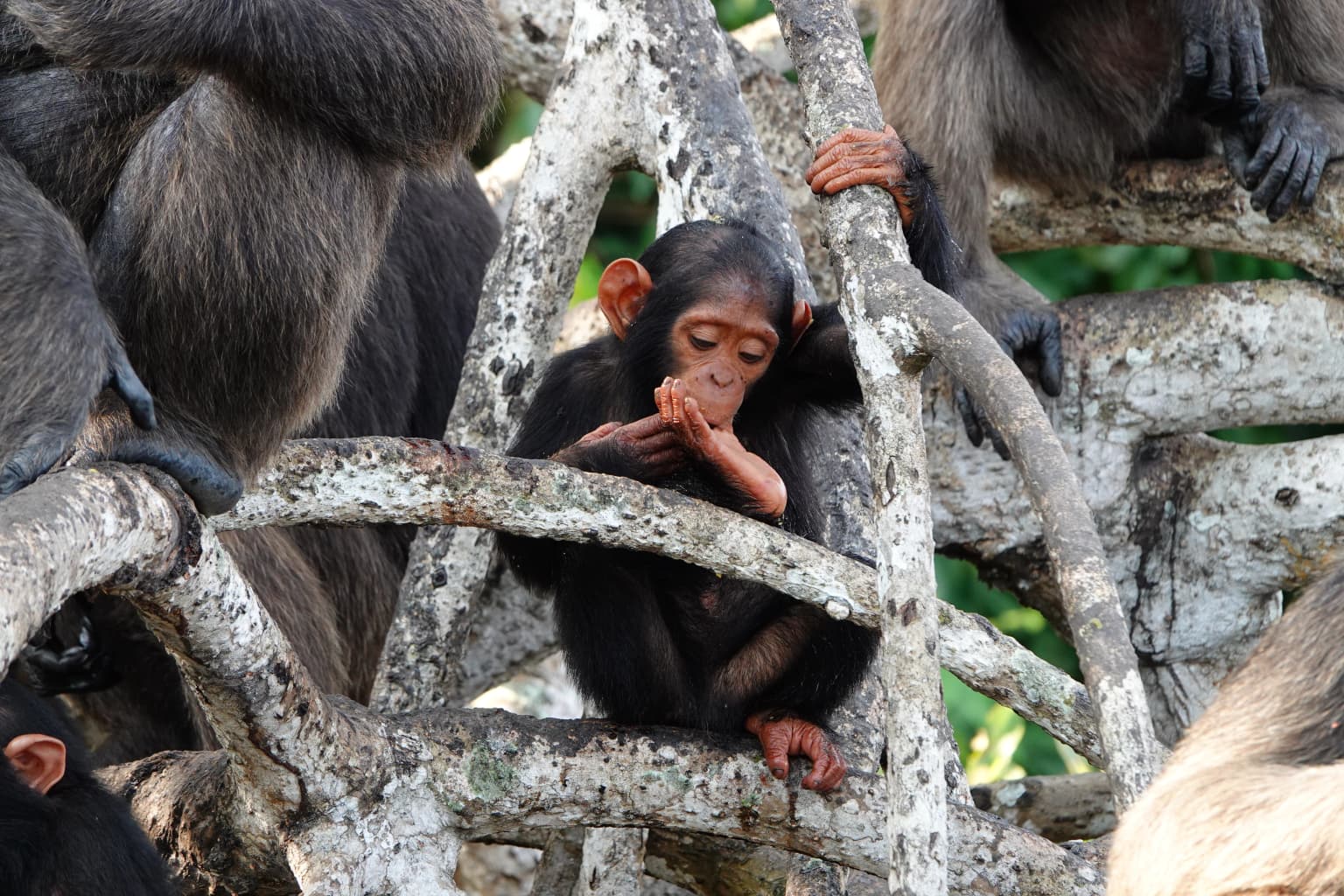
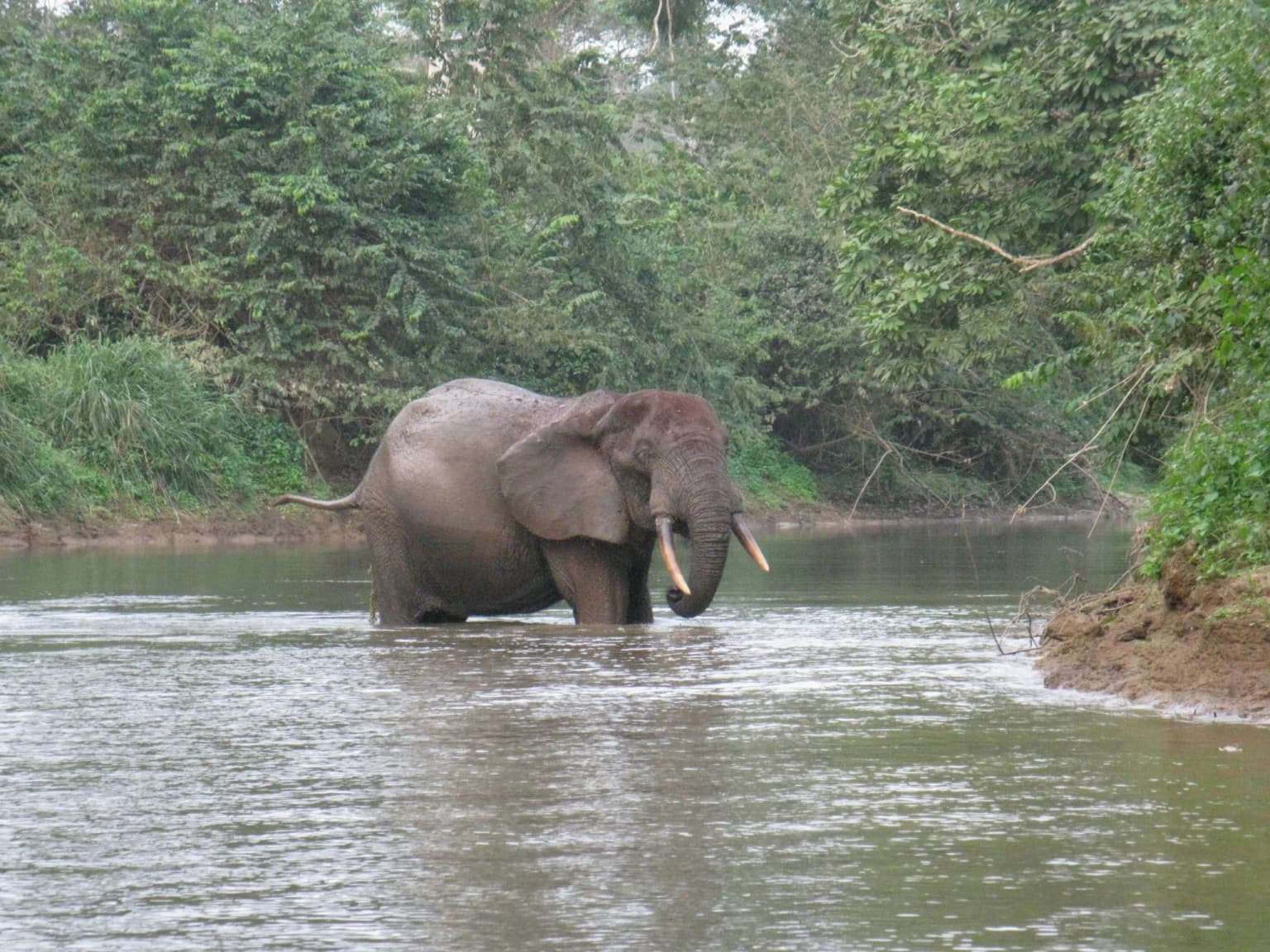
Conkouati-Douli National Park is best known for its extraordinary great ape populations, particularly the approximately 7,000 central chimpanzees and 900 western lowland gorillas that inhabit its dense forest ecosystems, making it a priority site in the IUCN great ape conservation action plan. The park is also globally significant for its marine biodiversity, featuring the only protected marine area in the Republic of Congo and hosting one of the world's most important nesting beaches for leatherback sea turtles. Its coastal mangroves, floodplain forests, and wetland systems support a remarkable concentration of biodiversity that includes forest elephants, mandrills, and over 100 humpback dolphins. The park's position at the mouth of the Congo River creates a unique ecological interface between terrestrial and marine environments, supporting both Congo Basin forest species and coastal marine life.

A young chimpanzee sitting on a tree branch with other chimpanzees in a forest setting.
Young chimpanzee interacting with other chimpanzees in the forest canopy of Conkouati-Douli National Park.

Conkouati-Douli National Park history and protected-area timeline

Conkouati-Douli National Park has evolved through several distinct phases of protection and management. The area was originally part of a larger reserve established in the early 1980s, which covered nearly 300,000 hectares before a legal provision in 1989 reduced it to 144,294 hectares. During the period from 1994 to 1999, the International Union for Conservation of Nature recognized the area as critically endangered and collaborated with PROGECAP-GEF Congo, financed by the World Bank, in partnership with Congolese authorities to address the urgent conservation needs. Following its formal establishment as a national park in 1999, Conkouati-Douli was managed by the Ministry for National Forestry Commission in partnership with the Wildlife Conservation Society until that collaboration concluded in 2018. The transition to new management arrangements saw Noé, a conservation organization founded in 2001, assume responsibility for the park's conservation initiatives beginning in 2019. The partnership was formalized through a 20-year management mandate signed on 13 April 2021, representing a renewed commitment to biodiversity conservation and sustainable development. The park holds deep cultural significance for the approximately 7,800 residents living in its 31 villages, predominantly the Vili people who settled along the coast in the 13th century as fishers and traders, while villages along the forest road contain a mix of over 30 different ethnic groups who arrived with the industrial forestry sector less than a century ago.

Conkouati-Douli National Park landscape and geographic character

The landscape of Conkouati-Douli National Park displays remarkable diversity, shaped by the transition from Congo Basin forests to coastal marine environments. The terrestrial portion encompasses approximately 3,833 square kilometers of land dominated by dense tropical forests that intermingle with extensive wetland systems, floodplain forests, and coastal lagoons. The Noumbi River flows through the heart of the park, its waters weaving through the forested landscape and connecting to the broader drainage system. Along the coast, extensive mangrove forests dominated by Rhizophora racemosa and Avicennia germinans create a distinctive tidal ecosystem where land and sea meet. The marine portion of the park covers 4,121 square kilometers, encompassing coastal waters, beaches, and the productive waters of the Atlantic where the Congo River's sediments create unusually fertile fishing grounds. In the southwestern and northeastern reaches, the forest gives way to savanna formations characterized by different grass species: the southwestern savannas feature Ctenium newtonii, Elytonrus brazzae, and Pobeguinea arrecta, while the northeastern savannas around Cotovindou are dominated by Hyparrhenia diplandra, Panicum phragmitoides, and Pobeguinea arrecta. The park's terrain ranges from flat coastal lowlands to slightly elevated forest ridges, with the landscape creating natural corridors that enable wildlife movement between the forest interior and the coast.

A forest elephant with visible tusks standing in shallow water surrounded by lush green vegetation
Forest elephant wading through a river in dense forest

Conkouati-Douli National Park ecosystems, habitats, and plant life

Conkouati-Douli National Park stands as the most biodiverse protected area in the Republic of the Congo, representing a critical stronghold for Central African biodiversity. The park's ecological significance stems from its unique position as the country's only protected marine area, creating a seamless continuum between terrestrial and marine ecosystems. The vegetation patterns reflect this diversity: dense evergreen forests dominate the interior, characterized by the complex stratified structure typical of Congo Basin rainforests, while wetlands and floodplain forests occupy the lower-lying areas where seasonal flooding creates distinct habitat zonation. The mangrove systems along the coast represent some of the most productive ecosystems in the region, providing nursery grounds for fish and crustaceans while stabilizing the shoreline and filtering sediments from incoming waters. Freshwater aquatic vegetation in lakes and lagoons includes species such as Vossia cuspidata, adapted to the variable water conditions. The savanna enclaves within the forest matrix represent fire-maintained or edaphic grassland formations that persist due to local soil conditions or historical disturbance patterns. This mosaic of habitats supports extraordinary species richness, making the park a priority conservation area not only for Congo but for the broader Central African region.

Conkouati-Douli National Park wildlife and species highlights

The wildlife of Conkouati-Douli National Park represents one of the most significant concentrations of biodiversity in Central Africa. The park hosts exceptional populations of great apes, with an estimated 7,000 central chimpanzees and 900 western lowland gorillas inhabiting its forest ecosystems, prompting its designation as a priority site in the IUCN great ape conservation action plan. Forest elephants, numbering approximately 900 individuals, traverse the park's interior, though their populations face significant pressure from poaching. The mammalian fauna includes African buffaloes, leopards, red river hogs, sitatungas adapted to wetland environments, and large troops of mandrills that move through the forest understory. The park's significance extends to marine species, with its beaches ranking among the world's most important nesting sites for leatherback sea turtles, while the coastal waters support a population of approximately 100 humpback dolphins. As a Ramsar site and Important Bird Area, the park provides critical habitat for migratory and wetland birds, with numerous species dependent on the lagoon systems and coastal environments. The diverse habitats support a rich avifauna, though precise species counts vary with seasonal movements and survey efforts.

Conkouati-Douli National Park conservation status and protection priorities

Conkouati-Douli National Park represents a critical conservation priority for both the Republic of the Congo and the broader Central African region, recognized through multiple international designations including UNESCO status, Ramsar Convention listing, and Important Bird Area recognition by BirdLife International. The park's conservation value stems from its exceptional biodiversity, including significant populations of great apes, forest elephants, and marine species, as well as its role as the only marine protected area in Congo. However, the park faces substantial threats from industrial activities including logging, mining, petroleum production, and commercial fishing, with poachers using the coastal and forest roads to access rare animals. The proximity to Pointe-Noire creates ongoing pressure from bushmeat hunting and wood extraction to meet the city's growing demands. Chinese-owned trawler boats pose a significant threat to marine ecosystems, while the planned oil drilling by Congo Holding United since 2024 represents a new and potentially severe threat to both biodiversity and indigenous communities. Conservation efforts are coordinated through the Ministry of Forest Economy and Sustainable Development in partnership with the NGO Noé, supported by technical and financial partners including the Wildlife Conservation Society, African Parks Network, Jane Goodall Institute, and various international donors including the European Union and United States Fish and Wildlife Service.

Conkouati-Douli National Park cultural meaning and human context

Conkouati-Douli National Park is deeply intertwined with the cultural landscape of the Congolese coast, home to approximately 7,800 people distributed across 31 villages within and adjacent to its boundaries. The coastal residents are predominantly Vili people, an ethnic group with roots as fishers and traders who settled in the region during the 13th century and maintain traditional connections to the marine environment. The villages along the forest road contain a more diverse population, with over 30 different ethnic groups represented, many of which arrived within the past century in association with the industrial forestry sector that developed in the region. These communities maintain relationships with the land that include both traditional resource use and more recent patterns of settlement and economic activity. The park's management framework recognizes the importance of community involvement, with the eco-development zone explicitly permitting sustainable resource use by residents and incorporating socio-economic activities into the broader conservation approach. The cultural context reflects the complex interplay between long-established coastal traditions and more recent patterns of migration and economic development that together shape the human dimension of this protected landscape.

Top sights and standout views in Conkouati-Douli National Park

Conkouati-Douli National Park offers exceptional opportunities to experience some of Central Africa's most iconic wildlife in a coastal setting unique within the region. Visitors can explore vast mangrove forests by boat, observe chimpanzee and gorilla populations in their natural forest habitat, witness leatherback sea turtles nesting on pristine beaches, and encounter humpback dolphins in the coastal waters. The park's zonation system allows for different visitor experiences, from regulated wildlife viewing in protected areas to cultural engagement with local communities in the eco-development zone. The diversity of habitats, from dense forest to coastal savanna to marine environments, supports remarkable species richness within a relatively compact area. The park's status as the most biodiverse in Congo, combined with its UNESCO recognition and Ramsar designation, underscores its international conservation significance while providing visitors with meaningful encounters with some of Africa's most threatened species and ecosystems.

Best time to visit Conkouati-Douli National Park

The optimal time to visit Conkouati-Douli National Park depends on the specific experiences sought, though the dry season from June to September generally offers more accessible trail conditions and clearer visibility for wildlife viewing in the forest interior. This period coincides with lower water levels in wetlands and lagoons, which can concentrate wildlife around remaining water sources and facilitate sightings of forest elephants, chimpanzees, and gorillas. The coastal marine activities may be more comfortable during the slightly cooler dry season months, though leatherback sea turtle nesting occurs year-round with peaks that may vary. The wet season brings renewed vitality to the forest and increased bird activity, with migratory species arriving to exploit the abundant food resources in the wetlands and lagoons. Visitors should note that the park's remote location and limited infrastructure require advance planning, and the zonation system means that access to certain areas requires permits and guided arrangements. The park's management recommends checking current conditions and requirements before planning visits, as conservation activities and community schedules can affect availability.

Park location guide

Geography guide, regional context, and park location map for Conkouati-Douli National Park

Conkouati-Douli National Park park geography, regions, and map view in Congo
Understand where Conkouati-Douli National Park sits in Congo through a broader geographic reading of the surrounding landscape, nearby location context, and its mapped position within the national park landscape.

How Conkouati-Douli National Park fits into Congo

Congo is a geographic term referring to multiple entities in central Africa. The most notable are the Democratic Republic of the Congo (DRC) and the Republic of the Congo (Congo-Brazzaville), both named after the Congo River which forms much of their border. The term also encompasses the Congo Basin, the river itself, historical kingdoms, and various other uses.

Wider geography shaping Conkouati-Douli National Park in Congo

Central Africa region encompassing the Congo River basin and surrounding areas.

Map view of Conkouati-Douli National Park

Use this park location map to pinpoint Conkouati-Douli National Park in Congo, understand its exact geographic position, and read its mapped placement within the surrounding landscape more clearly.

Pigeon | © OpenStreetMap contributors

Location context for Conkouati-Douli National Park

Kouilou Department

Explore the Diverse Scenery and Habitats of Congo's Premier Marine Protected Area

Conkouati-Douli National Park Photos: Visual Guide to Coastal Forests, Marine Habitats, and Savanna Landscapes
Visually explore the complex ecosystems of Conkouati-Douli National Park, from its dense tropical forests and expansive wetlands to vital coastal mangroves and unique savanna zones. These images offer a deep understanding of the park's diverse terrain, critical great ape habitats, and globally significant marine protected areas, showcasing its rich environmental character.

A young chimpanzee sitting on a tree branch with other chimpanzees in a forest setting.

Wide view of a lush green landscape with a winding path, water body, and forested shoreline under an overcast sky

A forest elephant with visible tusks standing in shallow water surrounded by lush green vegetation

Park atlas

Compare coastal protected landscapes and forest ecosystems across the Republic of the Congo and adjacent regional geography.

Explore Nearby National Parks and Protected Areas around Conkouati-Douli National Park
Explore other national parks and protected areas near Conkouati-Douli National Park, tracing diverse coastal, wetland, and forest ecosystems within the Republic of the Congo's regional geography. Compare these distinct conservation landscapes to understand the broader park geography and discover connected habitats around this globally significant marine and terrestrial site.
National parkGabon

Mayumba National Park: Gabon's Equatorial Protected Area and Geographic Atlas

Explore mapped park boundaries and regional landscape context.

Delve into the geographic identity of Mayumba National Park, a significant protected area situated in Gabon. This detail page provides atlas-style insights into the park's mapped boundaries, its position within the equatorial geography of Central Africa, and its role as a national park. Understand the protected landscape's environmental context and its atlas significance.

Area
870 km²
Established
2002
IUCN
II
Relief
Lowland
National parkGabon

Moukalaba-Doudou National Park: Gabon's Forest-Savanna Mosaic Protected Landscape

Atlas exploration of unique habitats and geographic boundaries.

Moukalaba-Doudou National Park in Gabon offers a distinctive atlas exploration experience, characterized by its remarkable combination of humid tropical rainforest and savanna grasslands. Covering a vast area, this protected landscape provides critical habitat and showcases a rare ecological transition zone within Central Africa. Understanding its mapped geography and protected-area status is key to appreciating Gabon's conservation efforts and the diverse natural terrains it preserves.

Area
4,500 km²
IUCN
II
Scope
Terrestrial
Water
Minor water
National parkGabon

Birougou National Park: Mapped Protected Landscape and Regional Geography in Gabon

Explore the geographic extent and conservation context of this national park.

Birougou National Park is an important protected area situated in Gabon, offering a distinct focus for geographic and atlas-based discovery. This national park serves as a significant element within the country's network of conservation landscapes, providing a focal point for understanding mapped terrain and regional geographic patterns. Users can explore its protected boundaries and gain insight into its specific environmental context within Central Africa, making it a vital entry for atlas exploration of Gabon's natural heritage.

Area
690 km²
Established
2002
IUCN
II
Relief
Mountain
National parkGabon

Loango National Park: Gabon's Coastal Wilderness and Unique Protected Landscape

Explore savanna, forest, beach, and lagoon ecosystems in this vital national park.

Loango National Park in Gabon is a significant protected area recognized for its remarkable geographic diversity. This national park encompasses over 100 kilometers of pristine, uninhabited Atlantic coastline, rare mangrove systems, and expansive savanna plains transitioning into dense tropical forests. Its unique landscape, particularly the Iguéla Lagoon, offers rich opportunities for atlas-style exploration of coastal ecosystems and protected areas. Understanding the park's mapped boundaries and regional setting is key to appreciating its ecological importance.

Area
1,550 km²
Established
2002
IUCN
II
Relief
Lowland
National parkGabon

Waka National Park: A Mapped Protected Landscape in Gabon's Geography

Explore the natural terrain and park boundaries of this national park.

Waka National Park in Gabon represents a vital protected landscape for geographic exploration. This dedicated detail page offers insight into the park's specific mapped area and its place within the country's broader natural terrain. Understand its context as a national park, contributing to the atlas of protected areas in Central Africa. Discover the geographic identity of this significant natural reserve.

Area
1,060 km²
Established
2002
IUCN
II
Relief
Mountain
National parkHaut-Ogooué Province

Batéké Plateau National Park: Mapped Geography of a Central African Forest-Savanna Mosaic

Discover the terrain and protected landscape of Haut-Ogooué Province.

Batéké Plateau National Park is defined by its expansive forest-savanna mosaic, a rare ecological formation across Central Africa. Located within Haut-Ogooué Province, this national park showcases unique terrain characterized by savanna grasslands interspersed with woodlands and forested corridors. Understanding its geographic context and protected boundaries provides valuable insight into the region's natural heritage and conservation significance.

Area
2,034 km²
Established
2002
IUCN
II
Relief
Upland
Watercolor painting of a landscape with grassy areas, a lake, and distant hills under a light sky
National parkGabon

Lopé National Park: Gabon's Protected Landscape and National Park Geography

Explore mapped boundaries and natural terrain in Central Africa.

Delve into Lopé National Park, a designated national park situated in Gabon. This protected area serves as a crucial point for understanding the nation's geography and the distribution of its conservation landscapes. As an entry in the MoriAtlas, it offers a detailed view of its mapped territory and its contribution to the broader regional context of Central Africa, emphasizing its role in protected area atlas exploration.

Area
4,910 km²
Established
2002
IUCN
II
Relief
Mixed relief
National parkGabon

Ivindo National Park: A Protected Rainforest Landscape in Gabon

Explore its waterfalls, diverse ecosystems, and mapped geographic context.

Ivindo National Park represents a significant protected landscape within Gabon, spanning a vast area of intact tropical rainforest. Recognized as a UNESCO World Heritage Site, the park is defined by the Ivindo River and its dramatic waterfalls, including the famous Kongou and Mingouli Falls. Its geography includes mountainous terrain and vital riverine ecosystems, supporting critical populations of forest elephants and great apes. This page offers a gateway to understanding the park's protected status, its unique natural features, and its role in the broader geography of Central Africa.

Area
3,000 km²
Established
2002
IUCN
II
Relief
Mixed relief

Common questions about visiting, size, designation, and location context for Conkouati-Douli National Park

Conkouati-Douli National Park FAQs for park facts, access, geography, and protected area context
Find quick answers about Conkouati-Douli National Park, including protected-area facts, park geography, trail and visitor context, and how the park fits into its surrounding country and regional landscape.
MoriAtlas Explorer

Continue Your Protected Areas Search Across the Global Atlas

Deepen your exploration by continuing the structured search for national parks and protected areas worldwide. Utilize the comprehensive filtering capabilities to compare different conservation landscapes and refine your understanding of global park geography. Discover more about the distribution and characteristics of protected natural areas.

Global natural geography