

Mori Atlas logo
National parkMolle Islands National Park

Mapped park boundaries and geographic context within northeastern Australia's varied terrain.

Molle Islands National Park: Queensland National Park Atlas and Protected Landscape

Molle Islands National Park represents a significant protected national park within Queensland, Australia. This page details its geographic identity, offering insights into its mapped boundaries and how it fits into the broader regional landscape of northeastern Australia. It serves as a key point for understanding the park's protected status and its place within the atlas of natural protected areas.

Island national parkQueensland protected areaWhitsunday islandsCoastal ecosystemsEucalypt forestRainforest gullies

Molle Islands National Park

National park

Park overview

Structured park overview, official facts, and landscape profile for Molle Islands National Park

Molle Islands National Park park facts, protected area profile, and essential visitor context
Review the core facts for Molle Islands National Park, including designation, size, terrain, visitor scale, habitats, and operating context in one park-focused overview.

About Molle Islands National Park

Molle Islands National Park occupies a distinctive position within Queensland's protected area network as an island-based park in the Whitsunday region, one of Australia's most renowned coastal destinations. The park encompasses nine islands and island groups spread across a relatively compact 18-square-kilometre area, creating a protected archipelago that preserves both terrestrial and coastal environments. Each island contributes different landscape characteristics, from the sandy beaches that fringe the island shores to the forested interiors that rise from the coast.

The park's location in the Whitsunday region places it within a broader landscape of exceptional natural beauty, where continental islands rise from the Coral Sea amid sheltered waters and complex coastlines. The islands represent continental fragments that support distinct ecological communities adapted to island environments and the influences of coastal and marine systems. Visitors to the park experience a combination of natural environments that would be difficult to find together in larger mainland protected areas.

Access to the park occurs through boat services from Airlie Beach and Shute Harbour, with tour operators providing both day trip options and ferry connections to nearby resort islands. This accessibility makes Molle Islands a practical destination for visitors exploring the Whitsunday region, offering protected island environments without requiring extensive travel arrangements. The park provides camping facilities at various locations, some equipped with picnic tables and toilets, while maintaining restrictions on open fires to protect island ecosystems.

Quick facts and research context for Molle Islands National Park

Molle Islands National Park spans 18 square kilometres across multiple continental islands in the Whitsunday region of North Queensland, Australia. The park is situated near the coastal town of Airlie Beach, from which visitors access the islands by boat. The island group includes Long Island, South Molle Island, North Molle Island, Mid Molle Island, and several smaller islands including Tancred, Repair, Planton, Goat, and Denman islands. The park features a mix of sandy beaches, eucalypt forests, rainforest gullies, and grassland environments. Management is provided by the Queensland Parks and Wildlife Service under IUCN Category II protected area designation.

Park context

Deeper park guide and search-rich context for Molle Islands National Park

Molle Islands National Park history, landscape, wildlife, and travel context
Explore Molle Islands National Park through its history, landscape character, ecosystems, wildlife, conservation priorities, cultural context, and seasonal travel timing in a structured park guide built for atlas discovery and search intent.

Why Molle Islands National Park stands out

Molle Islands National Park is best known for its accessible island nature within the famous Whitsunday archipelago, offering a protected landscape that combines beach, forest, and coastal environments across multiple islands. The park provides marked walking tracks, particularly on South Molle Island and Long Island, where visitors can explore island ecosystems through maintained trails suitable for various fitness levels. The diversity of habitats within a relatively small area, including the contrast between open eucalypt forests and shaded rainforest gullies, defines the park's character. The presence of vulnerable species including the coastal sheath-tailed bat and beach stone-curlew highlights the conservation significance of these island habitats.

Molle Islands National Park history and protected-area timeline

Molle Islands National Park was established as a protected area under Queensland's conservation framework, designated to preserve the island environments within the Whitsunday archipelago. The formation of the park reflected growing recognition of the ecological and landscape value of these continental islands, which had previously experienced varying levels of human use and modification. Establishment as a national park brought formal protection to island ecosystems and the biodiversity they support.

The Ngaro people are recognized as the traditional owners of the Molle Islands, with their connection to these lands and waters extending across generations before European settlement of the Queensland coast. This indigenous heritage represents the human dimension of the islands' history, though the source material provides limited detail on the specific nature of Ngaro connection to the islands or historical use patterns. The park's management acknowledges this traditional ownership as part of the broader context for the protected area.

Molle Islands National Park landscape and geographic character

The landscape of Molle Islands National Park is defined by its island setting within the Whitsunday archipelago, where each island contributes distinct physical characteristics to the park's overall character. The islands feature white sandy beaches that fringe their coastlines, creating the visual appearance typically associated with tropical island environments. Behind these beaches, the terrain rises through various vegetation zones to form the interior landscapes of each island.

Open eucalypt forests dominate the island interiors across much of the park, creating a characteristically Australian forest environment that contrasts with the tropical beach settings. These eucalyptus-dominated areas give way in places to rainforest-clad gullies, where moisture accumulation and shelter from wind create conditions suitable for denser vegetation. Grassland areas add further variety to the island landscapes, particularly in sections where forest gives way to more open terrain. The combination of these landscape elements within a compact island area creates a diverse visual and ecological environment.

Molle Islands National Park ecosystems, habitats, and plant life

The ecological character of Molle Islands National Park reflects the blend of Australian continental island environments with coastal and marine influences from the surrounding Coral Sea. The park's vegetation communities include open eucalypt forests as the dominant terrestrial formation, supplemented by rainforest patches in protected gullies and coastal vegetation along shorelines. This vegetation pattern creates habitat diversity that supports various species across the islands.

Biodiversity surveys have recorded 211 different species within the park, a notable figure for an island protected area of relatively modest size. The species complement includes both widespread Australian fauna and species with more restricted distributions tied to island environments or specific habitat types within the park. The presence of vulnerable species highlights the conservation importance of these island habitats, with the park serving as a refuge for species that face pressures in other parts of their range.

Molle Islands National Park wildlife and species highlights

The wildlife of Molle Islands National Park includes species adapted to island environments and the diverse habitats found across the island group. Two vulnerable species have been documented within the park: the coastal sheath-tailed bat and the beach stone-curlew. These species represent the park's conservation significance beyond simple species counts, as their presence indicates the importance of the island habitats for species that face population pressures in other areas.

The coastal sheath-tailed bat occupies coastal forest and woodland habitats, utilizing the island environments for roosting and foraging activities. The beach stone-curlew inhabits sandy beach and coastal areas, feeding on invertebrates and small organisms in the intertidal zone. Beyond these specific vulnerable species, the broader wildlife community includes various birds, reptiles, and invertebrates that occupy different habitat zones across the islands, from beach environments through forest types to the rainforest gullies.

Molle Islands National Park conservation status and protection priorities

Molle Islands National Park serves as an important conservation unit within Queensland's protected area system, preserving island ecosystems that would otherwise face pressures from development and resource extraction. The park's IUCN Category II designation reflects its primary purpose of protecting natural landscapes and the biodiversity they contain while allowing for sustainable recreational use. The island environments, being relatively discrete and bounded, benefit from the clear boundaries that protected area status provides.

The presence of vulnerable species including the coastal sheath-tailed bat and beach stone-curlew demonstrates the park's role in species conservation, providing protected habitat for species whose populations have declined in other areas. The diversity of habitats within the park, from beach through forest to rainforest, creates ecological complexity that supports various species and ecological processes. Maintaining these island environments in natural condition represents a long-term conservation commitment within the broader Whitsunday regional context.

Molle Islands National Park cultural meaning and human context

The Molle Islands have cultural significance as the traditional country of the Ngaro people, whose connection to this coastal and island landscape predates European settlement of the Queensland coast. The Ngaro are recognized as the traditional owners of the islands within the park, representing indigenous heritage that forms part of the broader cultural landscape of the Whitsunday region. This traditional connection provides cultural context for the protected area beyond its ecological values.

The nature of Ngaro connection to the Molle Islands, including specific uses of island resources, historical patterns of occupation, and contemporary relationships with the landscape, is not extensively detailed in the available source material. However, the acknowledgment of traditional ownership establishes the human dimension of these islands and recognizes that conservation management occurs within a context of indigenous cultural connection to country.

Top sights and standout views in Molle Islands National Park

The standout features of Molle Islands National Park include its accessible island setting within the celebrated Whitsunday archipelago, where visitors can explore protected island environments with relative ease from the mainland. The marked walking tracks on South Molle Island and Long Island provide structured opportunities to experience island landscapes, with trails ranging from easy to more challenging routes. The combination of beach, forest, and rainforest environments within a compact area offers ecological variety that rewards exploration. Wildlife viewing opportunities, particularly for the vulnerable species that inhabit the islands, add another dimension to the park's appeal. The camping facilities allow for longer stays, enabling visitors to experience the islands beyond day-trip limitations.

Best time to visit Molle Islands National Park

The best time to visit Molle Islands National Park aligns with the broader Whitsunday region's optimal visitation season, which typically runs from May through October when weather conditions are generally drier and more comfortable for outdoor activities. The winter months in Queensland bring milder temperatures and reduced rainfall to the coast, creating favourable conditions for walking, camping, and beach activities. Summer months from November through April tend to be warmer and wetter, with higher humidity and greater chance of rainfall that can affect visitor comfort and some activities. The island setting provides some moderation of climatic conditions, but the general seasonal pattern applies to planning visits. Visitors should note that boat access is required to reach the islands regardless of season, and ferry and tour services may vary in frequency throughout the year.

Park location guide

Geography guide, regional context, and park location map for Molle Islands National Park

Molle Islands National Park park geography, regions, and map view in Australia
Understand where Molle Islands National Park sits in Australia through a broader geographic reading of the surrounding landscape, nearby location context, and its mapped position within the national park landscape.

How Molle Islands National Park fits into Australia

Australia is a constitutional monarchy and federal parliamentary democracy comprising six states and ten territories. With a population of nearly 28 million, it is one of the world's most urbanised countries, with most people concentrated on the eastern seaboard. The country has a high Human Development Index and is known for its cultural diversity, ancient Aboriginal heritage, and unique wildlife.

Wider geography shaping Molle Islands National Park in Australia

Australia occupies the entire Australian continent, the island of Tasmania, and numerous smaller islands. It is the world's flattest and driest inhabited continent, featuring vast deserts in the interior (the Outback), tropical rainforests along the eastern coast, and a coastline bordering the Indian and Pacific Oceans.

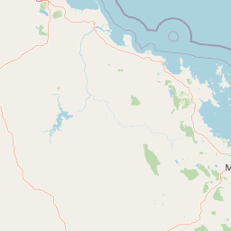
Map view of Molle Islands National Park

Use this park location map to pinpoint Molle Islands National Park in Australia, understand its exact geographic position, and read its mapped placement within the surrounding landscape more clearly.

Pigeon | © OpenStreetMap contributors

Location context for Molle Islands National Park

Queensland
Park atlas

Map the protected landscapes across the Whitsunday archipelago and Queensland coast, comparing a range of island and coastal park ecosystems.

Explore Other National Parks and Protected Areas Near Molle Islands National Park
After exploring Molle Islands National Park, browse other national parks and protected areas in the Whitsunday region and across Queensland. Compare island biodiversity, coastal ecosystems, and varied landscapes to understand the broader conservation efforts within Australia's protected area network.
National parkQueensland

Conway National Park: Queensland National Park Geographic Exploration and Protected Landscape

Mapped boundaries and regional natural terrain of this Australian national park.

Delve into Conway National Park, a key protected area situated in Queensland, Australia. This national park offers rich geographic discovery, allowing for detailed exploration of its mapped landscape and protected boundaries. Understand its role within the broader atlas of Australian natural regions, appreciating its specific landscape characteristics and its contribution to the regional geography of northeastern Australia.

Area
225 km²
Established
1938
IUCN
II
Relief
Lowland
National parkQueensland

Repulse Island National Park: Queensland's Coastal Protected Area and Mapped Geography

Explore this key national park's mapped boundaries and island landscape.

Repulse Island National Park is an important protected natural area offering unique insights into coastal island geography within Queensland's expansive conservation network. Established as a national park, it signifies a commitment to preserving representative natural landscapes. This page focuses on the mapped boundaries, regional geographic context, and the protected landscape identity of Repulse Island National Park, providing a detailed entry point for atlas-driven discovery of Australia's protected areas.

Area
1.51 km²
Established
1994
IUCN
II
Scope
Terrestrial
National parkQueensland

Lindeman Islands National Park: Queensland National Park Atlas and Protected Landscape

Explore mapped boundaries and regional geography within Queensland.

Lindeman Islands National Park is a designated national park offering insights into Queensland's protected natural landscapes. This page provides an atlas-style exploration of its geographic scope, mapped terrain, and role as a protected area within the northeastern Australian region. Understand its setting and unique landscape character for informed geographic discovery.

Area
33.1 km²
IUCN
II
Relief
Lowland
Climate
Tropical
National parkQueensland

Dryander National Park: Queensland's Protected Landscape and Geographic Identity

Mapped boundaries and natural terrain context in Queensland.

Delve into the protected landscape of Dryander National Park, a significant national park located in Queensland, Australia. This entry provides essential geographic context, detailing the park's boundaries and its representation within the broader regional atlas of protected areas. Understand its role as a mapped natural landscape contributing to the unique geography of Queensland, ideal for detailed exploration without travel logistics.

Area
118.82 km²
Established
1938
IUCN
II
Relief
Mountain
National parkQueensland

Whitsunday Islands National Park: Iconic Queensland National Park with Tropical Island Landscapes

Explore mapped protected boundaries and diverse coastal geography.

Whitsunday Islands National Park encompasses a remarkable collection of 74 islands off Queensland's coast, celebrated for their pristine tropical island landscapes and iconic Whitehaven Beach. This national park provides a unique opportunity to explore Australia's protected coastal and marine environments, offering detailed geographic context, mapped island topography, and insights into the park's role within the Great Barrier Reef World Heritage Area.

Area
170 km²
Established
1944
IUCN
II
Relief
Lowland
National parkQueensland

Smith Islands National Park: Queensland Coastal Protected Area Map

Discover the mapped geography and island landscapes of North Queensland.

Smith Islands National Park represents a significant protected island landscape off the coast of Queensland, Australia. This page allows for detailed exploration of its geographic features, mapped boundaries, and role as a national park within the North Queensland region's atlas of natural areas. Understand the unique character of these tropical islands and their place within Australia's network of preserved coastal environments.

Area
18.7 km²
IUCN
II
Scope
Terrestrial
National parkQueensland

Gloucester Island National Park: A National Park within Queensland's Diverse Geography

Mapped protected area and natural landscape context.

Gloucester Island National Park represents a distinct protected landscape in Queensland, Australia. This entry focuses on its identity as a national park, providing atlas-level detail on its geographic scope and mapped boundaries. Understand how this protected area fits within the broader natural terrain and regional geography of northeastern Australia, offering a unique lens for map-based exploration and discovery.

Area
29.6 km²
Established
1994
IUCN
II
Relief
Lowland
National parkQueensland

Cape Hillsborough National Park: Queensland's Volcanic Peninsula National Park

Mapped geography and protected landscape context in Central Queensland.

Cape Hillsborough National Park is a notable protected area defined by its unique volcanic peninsula landform in Queensland. Its rugged terrain features dense rainforest interiors that contrast with the surrounding coastal environments and tidal zones. As a national park, it offers an excellent opportunity to study landscape context, mapped geological features, and the distribution of protected natural areas within the Central Queensland region.

Area
10.22 km²
Established
1985
IUCN
II
Relief
Upland

Common questions about visiting, size, designation, and location context for Molle Islands National Park

Molle Islands National Park FAQs for park facts, access, geography, and protected area context
Find quick answers about Molle Islands National Park, including protected-area facts, park geography, trail and visitor context, and how the park fits into its surrounding country and regional landscape.
MoriAtlas Explorer

Continue Your Protected Areas Search Across the Global Atlas

Deepen your exploration by continuing the structured search for national parks and protected areas worldwide. Utilize the comprehensive filtering capabilities to compare different conservation landscapes and refine your understanding of global park geography. Discover more about the distribution and characteristics of protected natural areas.

Global natural geography