

Mori Atlas logo
National parkGloucester Island National Park

Discover the park's boundaries and natural terrain within Queensland's vast atlas.

Gloucester Island National Park: Mapped Protected Landscape and Regional Geography

Gloucester Island National Park stands as a significant protected area within the Australian state of Queensland. This national park offers a unique opportunity to explore its distinct natural landscapes and mapped geographic boundaries. Understand its place within the broader regional context of northeastern Australia, examining the protected land's form and its contribution to the area's diverse geography through a map-driven atlas lens.

Island protected areaBirdwatchingQueensland national parkCoastal ecosystemMigratory birdsCoral Sea

Gloucester Island National Park

National park

Park overview

Structured park overview, official facts, and landscape profile for Gloucester Island National Park

Gloucester Island National Park park facts, protected area profile, and essential visitor context
Review the core facts for Gloucester Island National Park, including designation, size, terrain, visitor scale, habitats, and operating context in one park-focused overview.

About Gloucester Island National Park

Gloucester Island National Park protects a coastal island ecosystem in the northern part of the Great Barrier Reef region along the Queensland coast. The park's establishment in 1994 reflected growing recognition of the ecological importance of the island's coastal habitats, beaches, and surrounding marine environment. Unlike the mountainous national parks common in Australia's interior, Gloucester Island represents a low-profile island landscape characterized by gentle terrain and coastal vegetation communities. The park provides protected habitat for numerous bird species and supports coastal ecosystem processes that contribute to the broader biodiversity of the region. Its visibility from Bowen offers a distinctive geographic relationship between the protected island and the mainland community, creating a natural landmark that defines part of the coastal landscape character around the town.

Quick facts and research context for Gloucester Island National Park

Gloucester Island National Park is located in Queensland, Australia, in the Coral Sea off the coast near Bowen. The park was established in 1994 and covers approximately 29.60 square kilometers. The terrain is predominantly low-lying with an average altitude of 34 meters above sea level. The park is managed by the Queensland Parks and Wildlife Service and holds IUCN Category II protected area status. The island was historically significant as an early geographical landmark noted by British explorer James Cook in 1770, though the name Cape Gloucester was later transferred to the mainland point immediately south of the island.

Park context

Deeper park guide and search-rich context for Gloucester Island National Park

Gloucester Island National Park history, landscape, wildlife, and travel context
Explore Gloucester Island National Park through its history, landscape character, ecosystems, wildlife, conservation priorities, cultural context, and seasonal travel timing in a structured park guide built for atlas discovery and search intent.

Why Gloucester Island National Park stands out

Gloucester Island National Park is best known for its seasonal birdwatching opportunities, particularly from October through April when thousands of migratory wading birds pass through the area. The park's coastal island setting provides important habitat for diverse bird species during their trans-equatorial migrations. The park is also notable for being a relatively accessible island protected area visible from the Queensland mainland, offering a distinct island conservation experience within reasonable proximity to the coastal town of Bowen.

Gloucester Island National Park history and protected-area timeline

Gloucester Island has historical significance in Australian coastal exploration. British explorer James Cook encountered the island during his 1770 voyage along the Queensland coast and erroneously applied the name Cape Gloucester to what he observed. The name was subsequently transferred by the Admiralty's hydrographer to the cape on the mainland immediately south of the island, which retains the Cape Gloucester designation to this day. This naming history reflects the common cartographic practice of the era where coastal features observed from sea were sometimes misattributed or had their names adjusted as geographic knowledge of the coastline improved. The island's identification as a distinct geographical feature predates its formal protection as a national park by over two centuries.

Gloucester Island National Park landscape and geographic character

The landscape of Gloucester Island National Park is characterized by low-lying coastal terrain averaging 34 meters in elevation, representing the remnant landscape of a continental island off the Queensland coast. The park encompasses the main island mass as well as components of neighboring islands within its protected boundaries. The coastal setting provides a mix of shoreline environments, beach areas, and inland vegetation zones characteristic of tropical island ecosystems in this region. The relatively flat topography contrasts with the mountainous mainland peaks visible from the island, creating a distinctive island silhouette against the Queensland sky.

Gloucester Island National Park ecosystems, habitats, and plant life

As a coastal island protected area in tropical Queensland, Gloucester Island supports vegetation communities adapted to island and coastal conditions. The park contributes to the network of protected areas along the Queensland coast that help maintain ecological connectivity for species moving between mainland and island habitats. The island's position within the broader Coral Sea region places it within one of Australia's most biodiverse marine and coastal environments. Protected area status ensures the maintenance of the island's natural values against development pressures and provides management frameworks for the ongoing conservation of its ecological communities.

Gloucester Island National Park wildlife and species highlights

The wildlife significance of Gloucester Island National Park is centered primarily on its role as a seasonal habitat for migratory bird species. From October to April, thousands of migrating birds transit through the area, with wading birds being particularly prominent. This seasonal phenomenon connects the island to the East Asian Australasian Flyway, one of the major migratory bird routes in the world. The park provides important resting and feeding habitat for these trans-equatorial migrants as they move between their breeding grounds in the northern hemisphere and non-breeding areas in Australia. The combination of coastal shoreline habitat and island environments creates suitable conditions for diverse birdlife during the migration season.

Gloucester Island National Park conservation status and protection priorities

Gloucester Island National Park contributes to Queensland's protected area network by preserving a coastal island ecosystem that might otherwise face development pressure. The park's IUCN Category II designation reflects its national park status and the formal recognition of its conservation values. Conservation of the island's coastal habitats supports broader ecosystem health in the region, while the protection of migratory bird habitat aligns with international conservation commitments. The Queensland Parks and Wildlife Service manages the park with responsibilities for maintaining natural values while providing for appropriate visitor experiences.

Gloucester Island National Park cultural meaning and human context

The cultural context of Gloucester Island includes its role in early European exploration of the Queensland coast. James Cook's 1770 encounter with the island and the subsequent naming transfer to the mainland Cape Gloucester represents a historical layer of colonial geographic naming. The island's relationship to the modern town of Bowen, which lies on the mainland coast to the south, creates a cultural and visual connection between the protected island and the regional community. While the park does not encompass specific documented indigenous cultural heritage in this source material, the broader Queensland coast has deep indigenous cultural connections spanning millennia.

Top sights and standout views in Gloucester Island National Park

The primary highlight of Gloucester Island National Park is its exceptional seasonal birdwatching opportunity, with thousands of migratory waders present from October to April each year. The park offers a rare island-based protected area experience within view of the Queensland mainland, making it distinctive among the state's national parks. The historical significance of Cook's encounter and the naming transfer adds a layer of exploration history to the park's identity. The park's low-lying island landscape provides a contrast to the mountainous terrain typical of many Australian national parks, offering a different type of protected area character.

Best time to visit Gloucester Island National Park

The best time to visit Gloucester Island National Park is during the birdwatching season from October to April, when thousands of migratory birds can be observed. The austral spring and summer months coincide with the peak migration period, making this the most biologically active time to experience the park. Visitors interested in birdwatching should plan their visit during these months to take advantage of the seasonal wildlife spectacle that the park is known for.

Park location guide

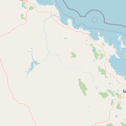
Geography guide, regional context, and park location map for Gloucester Island National Park

Gloucester Island National Park park geography, regions, and map view in Australia
Understand where Gloucester Island National Park sits in Australia through a broader geographic reading of the surrounding landscape, nearby location context, and its mapped position within the national park landscape.

How Gloucester Island National Park fits into Australia

Australia is a constitutional monarchy and federal parliamentary democracy comprising six states and ten territories. With a population of nearly 28 million, it is one of the world's most urbanised countries, with most people concentrated on the eastern seaboard. The country has a high Human Development Index and is known for its cultural diversity, ancient Aboriginal heritage, and unique wildlife.

Wider geography shaping Gloucester Island National Park in Australia

Australia occupies the entire Australian continent, the island of Tasmania, and numerous smaller islands. It is the world's flattest and driest inhabited continent, featuring vast deserts in the interior (the Outback), tropical rainforests along the eastern coast, and a coastline bordering the Indian and Pacific Oceans.

Map view of Gloucester Island National Park

Use this park location map to pinpoint Gloucester Island National Park in Australia, understand its exact geographic position, and read its mapped placement within the surrounding landscape more clearly.

Pigeon | © OpenStreetMap contributors

Location context for Gloucester Island National Park

Queensland
Park atlas

Explore Queensland's coastal island ecosystems and mainland protected landscapes surrounding Gloucester Island

Discover Nearby National Parks and Protected Areas Beyond Gloucester Island National Park
Browse other island protected areas and coastal ecosystems near Gloucester Island National Park, identifying their unique features and conservation focus. Compare regional park geography, trace protected boundaries across Queensland, and understand the diverse character of Australia's protected landscapes for comprehensive atlas discovery.
National parkQueensland

Dryander National Park: Queensland's Protected Landscape and Geographic Identity

Mapped boundaries and natural terrain context in Queensland.

Delve into the protected landscape of Dryander National Park, a significant national park located in Queensland, Australia. This entry provides essential geographic context, detailing the park's boundaries and its representation within the broader regional atlas of protected areas. Understand its role as a mapped natural landscape contributing to the unique geography of Queensland, ideal for detailed exploration without travel logistics.

Area
118.82 km²
Established
1938
IUCN
II
Relief
Mountain
National parkQueensland

Holbourne Island National Park: Queensland Coastal Wildlife Sanctuary and Maritime Atlas Entry

Explore the mapped geography and protected landscape of this small island national park.

Holbourne Island National Park, situated off the Queensland coast, serves as a vital protected area focused on coastal wildlife conservation. This 34-hectare national park is recognized for its importance as a natural bird sanctuary and a critical nesting ground for sea turtles, offering a focused point of discovery for marine ecosystem protection. Its landscape, characterized by coastal vegetation and rock formations, also holds a unique maritime history, notably tied to the SS Gothenburg shipwreck, making it a compelling destination for understanding Australia's island protected areas and their regional geographic context within the Coral Sea.

Area
0.34 km²
Established
1982
IUCN
II
Relief
Lowland
National parkQueensland

Conway National Park: Queensland National Park Geographic Exploration and Protected Landscape

Mapped boundaries and regional natural terrain of this Australian national park.

Delve into Conway National Park, a key protected area situated in Queensland, Australia. This national park offers rich geographic discovery, allowing for detailed exploration of its mapped landscape and protected boundaries. Understand its role within the broader atlas of Australian natural regions, appreciating its specific landscape characteristics and its contribution to the regional geography of northeastern Australia.

Area
225 km²
Established
1938
IUCN
II
Relief
Lowland
National parkQueensland

Whitsunday Islands National Park: Iconic Queensland National Park with Tropical Island Landscapes

Explore mapped protected boundaries and diverse coastal geography.

Whitsunday Islands National Park encompasses a remarkable collection of 74 islands off Queensland's coast, celebrated for their pristine tropical island landscapes and iconic Whitehaven Beach. This national park provides a unique opportunity to explore Australia's protected coastal and marine environments, offering detailed geographic context, mapped island topography, and insights into the park's role within the Great Barrier Reef World Heritage Area.

Area
170 km²
Established
1944
IUCN
II
Relief
Lowland
National parkQueensland

Molle Islands National Park: Queensland National Park Atlas and Protected Landscape Identity

Mapped boundaries and regional geographic context within northeastern Australia.

Molle Islands National Park is a designated national park located in Queensland, Australia. This dedicated atlas entry provides an understanding of its protected landscape character, focusing on its mapped geographic boundaries and its position within the regional context of northeastern Australia. Explore how this protected area contributes to the broader understanding of Queensland's natural geography and conservation lands.

Area
18 km²
IUCN
II
Climate
Tropical
Access
Moderate access
National parkQueensland

Mount Aberdeen National Park: A Queensland National Park with Unique Cloud Forest and Granite Peaks

Explore mapped terrain and protected landscape context in North Queensland.

Mount Aberdeen National Park represents a significant protected landscape in Queensland, defined by its striking granite peaks and an ecologically vital tropical cloud forest. This national park covers 29.10 square kilometers, showcasing unique flora such as hoop pine forests and rare red gum-snow grass communities. Its geographical position and unusual highland environment create a distinctive natural asset within the broader regional geography, offering valuable insights into Australia's protected area network and diverse ecosystems.

Area
29.1 km²
Established
1967
IUCN
II
Relief
Mountain
National parkQueensland

Repulse Island National Park: Queensland's Coastal Protected Area and Mapped Geography

Explore this key national park's mapped boundaries and island landscape.

Repulse Island National Park is an important protected natural area offering unique insights into coastal island geography within Queensland's expansive conservation network. Established as a national park, it signifies a commitment to preserving representative natural landscapes. This page focuses on the mapped boundaries, regional geographic context, and the protected landscape identity of Repulse Island National Park, providing a detailed entry point for atlas-driven discovery of Australia's protected areas.

Area
1.51 km²
Established
1994
IUCN
II
Scope
Terrestrial
Watercolor painting showing a coastal scene with sand, rocks, green trees, and mountains in the background
National parkQueensland

Cape Upstart National Park: Dramatic Queensland Coastal Protected Landscape

Explore Indigenous heritage and mapped terrain of this national park.

Cape Upstart National Park is a distinguished protected area in North Queensland, notable for its spectacular coastal headland that serves as a landmark against the Coral Sea. This park is a testament to the enduring connection between Indigenous heritage and natural landscapes, holding profound cultural significance for the Juru People whose ancestral lands it encompasses. Users can explore its mapped boundaries, diverse terrain from sandstone ridges to coastal dunes, and the intersection of geological features with deep cultural narratives, making it a crucial point for understanding protected area identity and regional geography.

Area
84.8 km²
Established
1969
IUCN
II
Relief
Lowland

Common questions about visiting, size, designation, and location context for Gloucester Island National Park

Gloucester Island National Park FAQs for park facts, access, geography, and protected area context
Find quick answers about Gloucester Island National Park, including protected-area facts, park geography, trail and visitor context, and how the park fits into its surrounding country and regional landscape.
MoriAtlas Explorer

Continue Your Protected Areas Search Across the Global Atlas

Deepen your exploration by continuing the structured search for national parks and protected areas worldwide. Utilize the comprehensive filtering capabilities to compare different conservation landscapes and refine your understanding of global park geography. Discover more about the distribution and characteristics of protected natural areas.

Global natural geography