

Mori Atlas logo
National parkLindeman Islands National Park

Discover the geographic boundaries and protected area context of this Queensland natural landscape.

Lindeman Islands National Park: Queensland National Park Atlas and Mapped Landscape

Lindeman Islands National Park represents a key protected area within the diverse geography of Queensland, Australia. This page offers an atlas-focused view, detailing its mapped boundaries and regional landscape context. Understand how this national park fits into the broader geography of northeastern Australia and explore its identity as a protected natural space.

Island ParksQueensland National ParksWhitsunday RegionCoastal WildernessAustralian IslandsTropical Islands

Lindeman Islands National Park

National park

Park overview

Structured park overview, official facts, and landscape profile for Lindeman Islands National Park

Lindeman Islands National Park park facts, protected area profile, and essential visitor context
Review the core facts for Lindeman Islands National Park, including designation, size, terrain, visitor scale, habitats, and operating context in one park-focused overview.

About Lindeman Islands National Park

Lindeman Islands National Park preserves a group of continental islands in the Whitsunday region of Queensland, protecting a slice of island wilderness along Australia's northeast coast. The islands are part of a chain that extends along the Queensland coast, formed from ancient continental material rather than coral reef foundations. This geological origin gives the islands their rugged, hilly character with slopes covered in tropical forest and woodland vegetation. The park's isolation from the mainland creates a distinct island ecosystem where native species have evolved in relative independence from continental pressures. Visitors to the Lindeman Islands experience a wilder side of the Whitsunday region compared to the developed resort islands that dominate the area's tourism profile. The park's relatively modest size concentrates significant natural values within a defined protected boundary, with the surrounding Coral Sea waters forming an integral part of the islands' ecological character. The protected area contributes to the network of island national parks that dot the Queensland coast, each preserving representative samples of the nation's island biodiversity and landscapes.

Quick facts and research context for Lindeman Islands National Park

The Lindeman Islands are continental islands located in the Whitsunday archipelago off the coast of Queensland, Australia. The national park covers approximately 33.10 square kilometres of land across the island group. The islands are situated roughly 885 kilometres north-northwest of Brisbane in the Coral Sea. The park falls under IUCN category II designation as a national park and is managed by the Queensland Parks and Wildlife Service. The islands feature typical tropical island landscapes with native vegetation covering their slopes and ridges.

Park context

Deeper park guide and search-rich context for Lindeman Islands National Park

Lindeman Islands National Park history, landscape, wildlife, and travel context
Explore Lindeman Islands National Park through its history, landscape character, ecosystems, wildlife, conservation priorities, cultural context, and seasonal travel timing in a structured park guide built for atlas discovery and search intent.

Why Lindeman Islands National Park stands out

The Lindeman Islands National Park is best known for its island wilderness character and its role in protecting continental islands within the Whitsunday region. The islands represent a preserved portion of Queensland's island ecosystems, offering a counterpoint to the more developed resort islands in the Whitsunday chain. The park provides protection for the island's native vegetation communities and the surrounding marine environments that are part of the broader Great Barrier Reef coastal and oceanic zone.

Lindeman Islands National Park history and protected-area timeline

The Lindeman Islands have long been part of the Whitsunday island chain, which has been inhabited by Indigenous peoples for thousands of years. The islands were named by early European explorers navigating the Queensland coast. The establishment of the national park reflects a recognition of the islands' natural values and the need to protect them from development pressures that have transformed many other Whitsunday islands into resort destinations. The formal protection of the Lindeman Islands as a national park preserves this island group as a reference point for the natural character of the Whitsunday region before extensive human modification.

Lindeman Islands National Park landscape and geographic character

The Lindeman Islands feature the rugged, hilly terrain characteristic of continental islands along the Queensland coast. Ancient rock formations form the core of the islands, with slopes rising from coastal plains and beaches to create a mountainous interior profile. The islands support tropical vegetation communities that cloak the hillsides in green throughout the year. Rocky headlands and sandy beaches mark the coastline, where the transition from terrestrial to marine environments occurs. The surrounding waters of the Coral Sea are typically clear and blue, consistent with the broader marine character of the Great Barrier Reef region.

Lindeman Islands National Park ecosystems, habitats, and plant life

The Lindeman Islands support tropical island vegetation communities adapted to the island environment. Native forest and woodland cover the island slopes, providing habitat for island-dwelling species. The islands exist within a broader marine environment of high biodiversity, where the proximity to the Great Barrier Reef influences the species composition of surrounding waters. The isolation of island ecosystems creates conditions for distinctive ecological assemblages, with species adapted to island life forming the basis of the park's terrestrial ecology.

Lindeman Islands National Park wildlife and species highlights

The Lindeman Islands provide habitat for native wildlife species adapted to island environments. Birdlife is a notable component of the islands' fauna, with various seabirds and forest-dwelling species occurring on the islands. The surrounding marine environments support fish species and other marine life common to the Great Barrier Reef region. The combination of island habitat and surrounding waters creates a diverse wildlife context that extends from the tree canopy to the coral reefs below the waterline.

Lindeman Islands National Park conservation status and protection priorities

Lindeman Islands National Park contributes to the protection of Queensland's island natural heritage within the Whitsunday region. The park preserves a group of islands that remain in relatively natural condition compared to many other Whitsunday islands that have been developed for tourism and residential use. The protection of the islands' terrestrial environments and the surrounding marine zone maintains ecological connections between island and ocean ecosystems. The national park designation ensures that the Lindeman Islands are retained as protected coastal and island wilderness into the future.

Lindeman Islands National Park cultural meaning and human context

The Lindeman Islands are located within the traditional Country of Aboriginal peoples who have occupied the Whitsunday islands and coastal areas for thousands of years. The islands are part of a cultural landscape that holds significance for Indigenous communities whose ancestors lived and travelled through these island environments. The park exists within a region of strong cultural heritage where island groups have been integrated into traditional Aboriginal生活 and maritime travel routes along the Queensland coast.

Top sights and standout views in Lindeman Islands National Park

The Lindeman Islands offer visitors a wilder island experience within the Whitsunday archipelago. The park provides access to islands that have retained their natural character without the resort development found on many neighbouring islands. The combination of island forests, coastal scenery, and surrounding reef waters creates a composite island wilderness experience. The park serves as a reminder of the natural Queensland island environment before extensive modification.

Best time to visit Lindeman Islands National Park

The Lindeman Islands can be visited year-round given Queensland's subtropical climate. The winter months from May to October typically bring drier, cooler conditions that make outdoor exploration more comfortable. The summer months from November to April bring warmer temperatures and the possibility of tropical rainfall, though this is also the period when the surrounding marine environments are at their most vibrant. The park's island setting means that weather conditions are influenced by both continental and marine weather patterns.
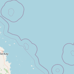

Park location guide

Geography guide, regional context, and park location map for Lindeman Islands National Park

Lindeman Islands National Park park geography, regions, and map view in Australia
Understand where Lindeman Islands National Park sits in Australia through a broader geographic reading of the surrounding landscape, nearby location context, and its mapped position within the national park landscape.

How Lindeman Islands National Park fits into Australia

Australia is a constitutional monarchy and federal parliamentary democracy comprising six states and ten territories. With a population of nearly 28 million, it is one of the world's most urbanised countries, with most people concentrated on the eastern seaboard. The country has a high Human Development Index and is known for its cultural diversity, ancient Aboriginal heritage, and unique wildlife.

Wider geography shaping Lindeman Islands National Park in Australia

Australia occupies the entire Australian continent, the island of Tasmania, and numerous smaller islands. It is the world's flattest and driest inhabited continent, featuring vast deserts in the interior (the Outback), tropical rainforests along the eastern coast, and a coastline bordering the Indian and Pacific Oceans.

Map view of Lindeman Islands National Park

Use this park location map to pinpoint Lindeman Islands National Park in Australia, understand its exact geographic position, and read its mapped placement within the surrounding landscape more clearly.

Pigeon | © OpenStreetMap contributors

Location context for Lindeman Islands National Park

Queensland
Park atlas

Compare Queensland's Island Wilderness and Coastal Protected Landscapes in the Whitsunday Region

Discover Related National Parks and Protected Areas Near Lindeman Islands National Park
Explore other national parks and protected areas near Lindeman Islands National Park, extending your view across Queensland's diverse coastal and island landscapes. Compare island wilderness, surrounding marine environments, and unique protected-area characteristics within the broader Whitsunday region and its distinctive geography.
National parkQueensland

Smith Islands National Park: Queensland Coastal Protected Area Map

Discover the mapped geography and island landscapes of North Queensland.

Smith Islands National Park represents a significant protected island landscape off the coast of Queensland, Australia. This page allows for detailed exploration of its geographic features, mapped boundaries, and role as a national park within the North Queensland region's atlas of natural areas. Understand the unique character of these tropical islands and their place within Australia's network of preserved coastal environments.

Area
18.7 km²
IUCN
II
Scope
Terrestrial
National parkQueensland

Repulse Island National Park: Queensland's Coastal Protected Area and Mapped Geography

Explore this key national park's mapped boundaries and island landscape.

Repulse Island National Park is an important protected natural area offering unique insights into coastal island geography within Queensland's expansive conservation network. Established as a national park, it signifies a commitment to preserving representative natural landscapes. This page focuses on the mapped boundaries, regional geographic context, and the protected landscape identity of Repulse Island National Park, providing a detailed entry point for atlas-driven discovery of Australia's protected areas.

Area
1.51 km²
Established
1994
IUCN
II
Scope
Terrestrial
National parkQueensland

Molle Islands National Park: Queensland National Park Atlas and Protected Landscape Identity

Mapped boundaries and regional geographic context within northeastern Australia.

Molle Islands National Park is a designated national park located in Queensland, Australia. This dedicated atlas entry provides an understanding of its protected landscape character, focusing on its mapped geographic boundaries and its position within the regional context of northeastern Australia. Explore how this protected area contributes to the broader understanding of Queensland's natural geography and conservation lands.

Area
18 km²
IUCN
II
Climate
Tropical
Access
Moderate access
National parkQueensland

Conway National Park: Queensland National Park Geographic Exploration and Protected Landscape

Mapped boundaries and regional natural terrain of this Australian national park.

Delve into Conway National Park, a key protected area situated in Queensland, Australia. This national park offers rich geographic discovery, allowing for detailed exploration of its mapped landscape and protected boundaries. Understand its role within the broader atlas of Australian natural regions, appreciating its specific landscape characteristics and its contribution to the regional geography of northeastern Australia.

Area
225 km²
Established
1938
IUCN
II
Relief
Lowland
National parkQueensland

Cape Hillsborough National Park: Queensland's Volcanic Peninsula National Park

Mapped geography and protected landscape context in Central Queensland.

Cape Hillsborough National Park is a notable protected area defined by its unique volcanic peninsula landform in Queensland. Its rugged terrain features dense rainforest interiors that contrast with the surrounding coastal environments and tidal zones. As a national park, it offers an excellent opportunity to study landscape context, mapped geological features, and the distribution of protected natural areas within the Central Queensland region.

Area
10.22 km²
Established
1985
IUCN
II
Relief
Upland
National parkQueensland

South Cumberland Islands National Park: Queensland's Dramatic Granite Island Protected Landscape

Explore its unique mapped geography and natural terrain.

South Cumberland Islands National Park, situated in Queensland, Australia, is a remarkable collection of islands characterized by dramatic granite landscapes, steep interior slopes cloaked in tropical rainforest, and surrounding coral fringing reefs. As the largest island, Scawfell Island rises to a prominent 397-metre peak, showcasing the island group's significant geological features and contributing to its distinct protected landscape identity within the Whitsunday region. Understanding this park offers insight into the mapped natural context of Australia's coastal protected areas.

Area
21.8 km²
IUCN
II
Relief
Mountain
Climate
Subtropical
National parkQueensland

Whitsunday Islands National Park: Iconic Queensland National Park with Tropical Island Landscapes

Explore mapped protected boundaries and diverse coastal geography.

Whitsunday Islands National Park encompasses a remarkable collection of 74 islands off Queensland's coast, celebrated for their pristine tropical island landscapes and iconic Whitehaven Beach. This national park provides a unique opportunity to explore Australia's protected coastal and marine environments, offering detailed geographic context, mapped island topography, and insights into the park's role within the Great Barrier Reef World Heritage Area.

Area
170 km²
Established
1944
IUCN
II
Relief
Lowland
National parkQueensland

Pioneer Peaks National Park: Queensland National Park Geography and Mapped Boundaries

Explore its protected landscape and regional context.

Pioneer Peaks National Park represents a distinct protected area within Queensland, Australia, offering valuable insights into regional geography and mapped natural landscapes. This canonical page focuses on the park's identity as a national park, detailing its geographic setting and the significance of its protected boundaries. It serves as a crucial point for understanding its place within the Australian atlas and the broader context of conservation landscapes.

Area
18.4 km²
Established
1992
IUCN
II
Relief
Mountain

Common questions about visiting, size, designation, and location context for Lindeman Islands National Park

Lindeman Islands National Park FAQs for park facts, access, geography, and protected area context
Find quick answers about Lindeman Islands National Park, including protected-area facts, park geography, trail and visitor context, and how the park fits into its surrounding country and regional landscape.
MoriAtlas Explorer

Continue Your Protected Areas Search Across the Global Atlas

Deepen your exploration by continuing the structured search for national parks and protected areas worldwide. Utilize the comprehensive filtering capabilities to compare different conservation landscapes and refine your understanding of global park geography. Discover more about the distribution and characteristics of protected natural areas.

Global natural geography