Mori Atlas logo
National parkMonga National Park

Discover the mapped boundaries and regional landscape setting of this Australian national park.

Monga National Park: New South Wales National Park Protected Area and Geographic Context

Monga National Park stands as a significant protected area within New South Wales, Australia. This entry focuses on its identity as a national park, providing detailed geographic context and mapping its protected boundaries. Users can explore the park's landscape features and its regional setting, offering valuable insights for atlas-based discovery and understanding its place within the broader geography of New South Wales.

National ParkAustraliaEucalyptus ForestTemperate RainforestNew South WalesMountain Landscape
Stylized illustration of a waterfall surrounded by tall trees and ferns with mountains in the background

Monga National Park

National park

Park overview

Structured park overview, official facts, and landscape profile for Monga National Park

Monga National Park park facts, protected area profile, and essential visitor context
Review the core facts for Monga National Park, including designation, size, terrain, visitor scale, habitats, and operating context in one park-focused overview.

About Monga National Park

Monga National Park represents a significant addition to New South Wales protected area network, established to conserve a distinctive mountain landscape that supports rare and localized ecosystems. The park lies within the Southern Tablelands, a region of elevated plateaus and rolling hills that marks the transition between the coastal landscapes of eastern Australia and the drier inland plains. The area's topography is characterized by steep, heavily timbered ridges and valleys that have historically limited agricultural development and human settlement, leaving much of the landscape in relatively natural condition. The protection of Monga ensures the preservation of ecological communities that have been significantly reduced in extent elsewhere in the state through clearing for agriculture and forestry. The park forms part of a broader connectivity corridor that links with other protected areas in the region, supporting landscape-scale conservation of biodiversity.

Quick facts and research context for Monga National Park

Monga National Park covers 251.44 square kilometres in the Southern Tablelands of New South Wales, Australia. The park was formally established on 1 January 2001 under the management of the NSW National Parks and Wildlife Service. The elevation reaches 686 meters, with the terrain characterized by mountainous country, deep valleys, and forested ridges. The closest settlement is Braidwood, a small historic town to the northeast of the park. The park contains the Corn Trail, a historic bridle-track constructed in the 1830s that has been restored for visitor use as a walking track.

Park context

Deeper park guide and search-rich context for Monga National Park

Monga National Park history, landscape, wildlife, and travel context
Explore Monga National Park through its history, landscape character, ecosystems, wildlife, conservation priorities, cultural context, and seasonal travel timing in a structured park guide built for atlas discovery and search intent.

Why Monga National Park stands out

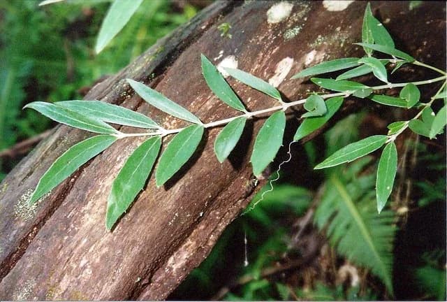
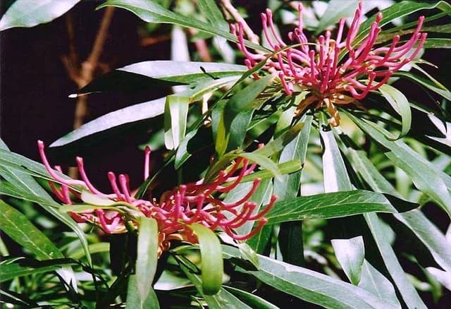
Monga National Park is distinguished for its remarkable combination of high-altitude eucalyptus forests and temperate rainforest that occur in close association, creating a unique ecological mosaic rarely found in other parts of New South Wales. The park protects some of the finest examples of wet sclerophyll forest in the region, dominated by towering eucalypts such as Eucalyptus fastigata, alongside ancient Antarctic beech and soft tree fern understories. The park is also known for several endemic plant species including the Monga Waratah (Telopea mongaensis), a striking.prostrate shrub that occurs only within this area, and the pinkwood (Eucryphia moorei), which grows as a hemiepiphyte on tree ferns in the rainforest understory. These botanical treasures make Monga particularly significant for plant conservation.

Green leaves of Atherosperma moschatum plant on a brown tree trunk with forest background
Close-up of Atherosperma moschatum plant in Monga National Park

Monga National Park history and protected-area timeline

Monga National Park was formally established on 1 January 2001, representing the culmination of decades of advocacy by conservation groups and local communities who recognized the outstanding natural values of the area. Prior to national park declaration, the land had been subject to various land uses including selective forestry and grazing, though the steep and inaccessible terrain limited the intensity of these activities. The creation of the park built upon earlier reservation efforts and addressed a gap in the protected area network of southern New South Wales. The Corn Trail, a historic bridle-track constructed in the 1830s, provides a tangible link to the European settlement period and serves as a reminder of the region's pastoral history. This route was originally used to move livestock between the coastal plains and the high country, and its restoration and reopening as a walking track allows visitors to experience a piece of the park's historical fabric while enjoying the natural landscape.

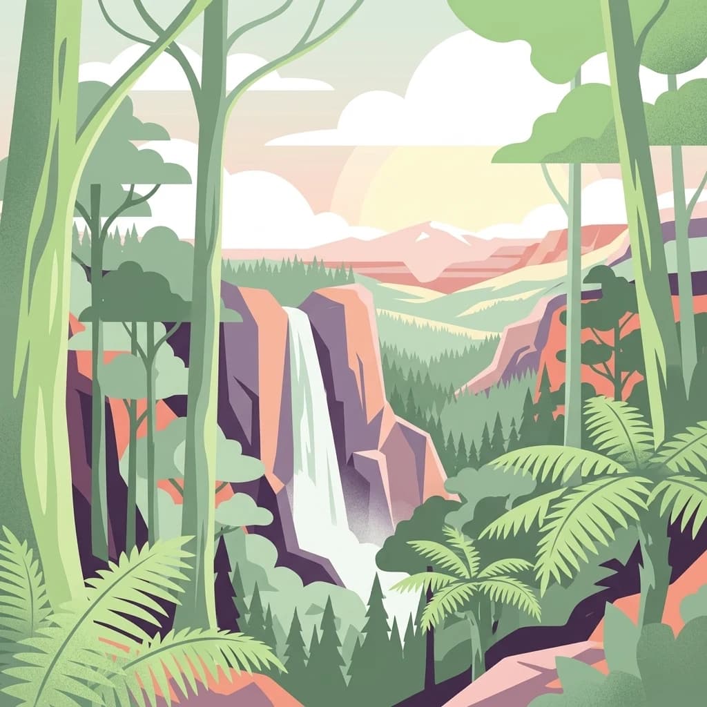
Monga National Park landscape and geographic character

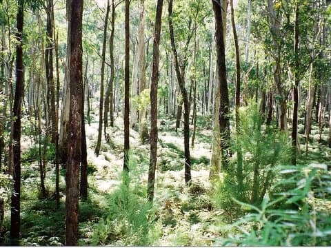
The physical landscape of Monga National Park is defined by its mountainous terrain and the diverse vegetation communities that blanket the slopes and valleys. The park sits at elevations between approximately 400 and 686 meters above sea level, with the highest points occurring along the main dividing ridge that separates the catchment basins flowing toward the Shoalhaven River. The terrain is characterized by steep, often rocky ridges and narrow valleys carved by creeks that descend through the landscape. The underlying geology comprises sedimentary and metamorphic rocks that influence soil types and drainage patterns across the park. Forest dominates the skyline, with the canopy varying from tall, open eucalypt forest on the ridges to dense, shaded rainforest in the sheltered gullies where moisture accumulates. The visual character changes with the seasons, from the fresh greens of spring and summer to the muted tones of winter when mist often clings to the valleys.

Close-up of Telopea mongaensis plant with bright pink flower spikes and glossy green leaves
Telopea mongaensis blooms with vibrant pink flower spikes in Monga National Park

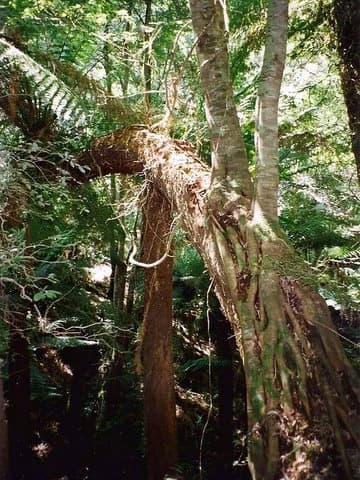
Monga National Park ecosystems, habitats, and plant life

The ecological character of Monga National Park centers on the exceptional combination of tall eucalyptus forest and temperate rainforest that occurs within the park boundaries. Wet sclerophyll forest, dominated by several eucalypt species including Eucalyptus fastigata, forms the predominant vegetation type across the ridges and upper slopes, characterized by a tall, open canopy with a diverse understory of shrubs, ferns, and grasses. In the deeper, more protected valleys and along creek lines, the vegetation transitions to temperate rainforest, also termed Antarctic beech forest, where canopy species such as Nothofagus cunninghamii create a darker, more enclosed environment. These rainforest patches support a distinctive suite of plant species including the southern sassafras (Atherosperma moschatum), soft tree fern (Dicksonia antarctica), and the endemic pinkwood. The park's position at the interface between different climate zones and its varied topography contributes to the diversity of habitats present.

Tall eucalyptus trees with green undergrowth in a forest setting
Tall eucalyptus trees in Monga National Park

Monga National Park wildlife and species highlights

The diverse forest habitats of Monga National Park support a range of wildlife species, though detailed faunal surveys are limited in the available source material. The tall eucalypt forests provide nesting and foraging habitat for various bird species, while the dense understory and groundcover support terrestrial mammals and reptiles. The presence of mature trees with hollows is likely to provide shelter for arboreal mammals such as possums and gliders, while the forest floor supports ground-dwelling mammals including bandicoots and antechinus. The rainforest gullies offer moist, sheltered environments favored by amphibians and invertebrates. The Corn Trail and other walking tracks provide opportunities for visitors to observe wildlife, though the park's relatively remote character means that many species remain elusive.

Tall trees and dense green vegetation including Eucryphia moorei and Soft Tree fern in a forest setting
Eucryphia moorei and Soft Tree fern in Monga National Park

Monga National Park conservation status and protection priorities

Monga National Park plays an important role in the conservation of New South Wales natural heritage by protecting representative examples of high-altitude forest ecosystems that have been extensively cleared across the tablelands region. The park conserves both wet sclerophyll forest and temperate rainforest communities, the latter of which has been particularly reduced by historic clearing and remains poorly represented in the formal protected area network. Several plant species found in the park are of conservation significance, including the endemic Monga Waratah which occurs only within a limited range. The protection of the park's waterways and riparian zones also contributes to water quality protection for the broader catchment. The establishment of Monga National Park filled a gap in the reserve system, connecting with other protected areas to form a more coherent landscape-scale conservation network in southern New South Wales.

Monga National Park cultural meaning and human context

Monga National Park holds significance for the Aboriginal peoples of the Yuin and Walbunja nations, whose traditional lands encompass the park area. The park contains numerous cultural sites that reflect thousands of years of Aboriginal occupation and connection to country. These sites include rock shelters, artifact scatter locations, and other places of traditional importance that are protected within the park boundaries. The cultural values associated with the landscape are an important dimension of the park's heritage, though detailed information about specific sites and their significance is not extensively documented in the available source material. European settlement of the area began in the early nineteenth century, with the Corn Trail representing one of the earliest routes developed to access the mountainous country for pastoral purposes.

Top sights and standout views in Monga National Park

Monga National Park offers visitors the opportunity to explore outstanding high-altitude forest environments within a relatively accessible distance of Sydney. The Corn Trail provides a notable walking experience, following a historic route through diverse forest types and past cultural sites. The park's botanical values are a particular highlight, with the Monga Waratah, pinkwood, and southern sassafras representing distinctive local species found in few other places. The combination of tall eucalyptus forest and cool temperate rainforest creates a scenic landscape that changes character as visitors move through different habitat types. The relative remoteness and limited visitor infrastructure contribute to a sense of wilderness that distinguishes Monga from more heavily developed parks closer to major population centres.

Best time to visit Monga National Park

The changing seasons offer different experiences for visitors to Monga National Park. Autumn and winter often bring misty conditions to the valleys, creating atmospheric forest scenery particularly suited to photography and contemplative bushwalking. Spring brings fresh growth and flowering of understory species, though the park is not known for dramatic wildflower displays. Summer months can be warm, making the shaded rainforest gullies particularly appealing for seeking cooler conditions. The park can be visited throughout the year, though visitors should be prepared for changeable mountain weather and should check road conditions before traveling, as access routes may be affected by weather events. The relatively limited facilities mean that self-sufficiency is important for visitors planning longer walks.

Park location guide

Geography guide, regional context, and park location map for Monga National Park

Monga National Park park geography, regions, and map view in Australia
Understand where Monga National Park sits in Australia through a broader geographic reading of the surrounding landscape, nearby location context, and its mapped position within the national park landscape.

How Monga National Park fits into Australia

Australia is a constitutional monarchy and federal parliamentary democracy comprising six states and ten territories. With a population of nearly 28 million, it is one of the world's most urbanised countries, with most people concentrated on the eastern seaboard. The country has a high Human Development Index and is known for its cultural diversity, ancient Aboriginal heritage, and unique wildlife.

Wider geography shaping Monga National Park in Australia

Australia occupies the entire Australian continent, the island of Tasmania, and numerous smaller islands. It is the world's flattest and driest inhabited continent, featuring vast deserts in the interior (the Outback), tropical rainforests along the eastern coast, and a coastline bordering the Indian and Pacific Oceans.

Map view of Monga National Park

Use this park location map to pinpoint Monga National Park in Australia, understand its exact geographic position, and read its mapped placement within the surrounding landscape more clearly.

Pigeon | © OpenStreetMap contributors

Location context for Monga National Park

New South Wales

Explore the Scenic Habitats and Rugged Terrain of Monga's Protected Natural Area in New South Wales, Australia

Monga National Park Photos: Visualizing Diverse High-Altitude Forests and Temperate Rainforest Landscapes
Visually explore the distinctive landscapes of Monga National Park, featuring rugged mountainous terrain, expansive high-altitude eucalyptus forests, and vital pockets of ancient temperate rainforest. These images provide essential geographic context for understanding the park's unique protected area character, diverse ecosystems, and conservation significance within the Southern Tablelands region.

Green leaves of Atherosperma moschatum plant on a brown tree trunk with forest background

Tall eucalyptus trees with dense ferns and mist in Monga National Park

Close-up of Telopea mongaensis plant with bright pink flower spikes and glossy green leaves

Tall eucalyptus trees with green undergrowth in a forest setting

Tall trees and dense green vegetation including Eucryphia moorei and Soft Tree fern in a forest setting

Park atlas

Compare protected landscapes and trace regional park geography in the Southern Tablelands of Australia.

Discover National Parks & Protected Areas Near Monga National Park, New South Wales
Continue your park discovery beyond Monga National Park by exploring other national parks and protected areas across the Southern Tablelands of New South Wales. Uncover additional mountainous terrain, high-altitude forests, and temperate rainforest ecosystems, facilitating a deeper atlas-style comparison of regional conservation landscapes.
National parkAustralia

Clyde River National Park: Australia's Protected Riverine Landscape and Swift Parrot Sanctuary

Discover its vital role in conservation and mapped geography.

Clyde River National Park is a critical protected area in Australia, safeguarding nine kilometers of river frontage along the Clyde River. Established for its ecological importance, particularly as a sanctuary for the endangered swift parrot, the park's landscape is characterized by riverine forests and eucalyptus woodlands. This designation highlights its role in preserving key habitats and contributing to the regional map of protected lands vital for biodiversity.

Area
10.91 km²
Established
2000
IUCN
II
Scope
Terrestrial
National parkNew South Wales

Bimberamala National Park: New South Wales National Park Protected Landscape Atlas

Mapped boundaries and regional geographic context for discovery.

Bimberamala National Park is a protected natural area within New South Wales, Australia, offering a distinct geographic profile. As a national park, its mapped boundaries and landscape characteristics are valuable for understanding regional protected areas and their distribution. This entity provides a focused point for atlas-based geographic exploration, allowing users to study its specific terrain and environmental context within the wider Australian geography.

Area
43.96 km²
Established
2001
IUCN
II
Relief
Upland
National parkNew South Wales

Budawang National Park: Wilderness Area and Rugged Terrain Map

Discover New South Wales protected landscape geography.

Budawang National Park is recognized for its exceptional wilderness character, defined by the steep topography of the southern Budawang Range. This protected national park features extensive cool temperate rainforests clothing its middle and upper slopes, creating a visually striking and ecologically rich mountain environment. Its rugged terrain, with deep valleys and rocky outcrops, distinguishes it as a remote natural landscape within New South Wales, offering unique habitat pockets and contributing to the region's protected area atlas.

Area
237 km²
Established
1977
IUCN
Ib
Relief
Mountain
National parkNew South Wales

Murramarang National Park: Discover Its Mapped Protected Area and New South Wales Geography

Explore the unique landscape and geographic features.

Murramarang National Park stands as a distinct protected area within New South Wales, offering a unique landscape to explore through its mapped boundaries and regional geographic context. This resource provides essential details for understanding its place in the atlas of Australian protected lands. Users can gain a factual appreciation of the park's physical geography and its identity as a national park, grounded in spatial data and mapped terrain.

Area
121 km²
Established
1973
IUCN
II
Relief
Mountain
National parkNew South Wales

Deua National Park: New South Wales National Park Exploration and Map Context

Discover protected landscape boundaries and regional geography.

Deua National Park offers a focused lens into Australia's protected areas, specifically within the state of New South Wales. This page provides detailed geographic context, enabling users to trace the park's boundaries and understand its position within the regional atlas. Explore the mapped terrain and the protected landscape identity that defines Deua National Park as a key component of conservation efforts in the area, ideal for a structured understanding of protected natural spaces.

Area
1,220 km²
Established
1979
IUCN
Ib
Relief
Mountain
National parkNew South Wales

Meroo National Park: Protected National Park in New South Wales with Mapped Landscape Identity

Explore the protected landscape and geographic context of this national park.

Meroo National Park is a protected national park located in New South Wales, Australia, offering specific geographic context for atlas exploration. This page provides details on its mapped boundaries and its identity as a conservation landscape. Understanding Meroo National Park's place within the regional geography of New South Wales is key to appreciating its protected status and unique natural characteristics, all within a framework designed for structured geographic discovery.

Established
2001
IUCN
II
Relief
Lowland
Climate
Temperate
Watercolor painting showing green hills, valleys, and distant mountains
National parkNew South Wales

Eurobodalla National Park: New South Wales Coastal Protected Landscape and Geographic Atlas

Explore its mapped protected boundaries and unique estuarine wetland habitats.

Eurobodalla National Park represents a critical segment of the New South Wales coastline, distinguished by its designation as a national park. The park's geography is characterized by a mosaic of coastal terrains, including sandy shores, river estuaries, and vegetated headlands, which collectively form essential protected landscapes. It is particularly recognized for its role in supporting migratory bird populations and serves as a key site for understanding coastal ecology and conservation efforts within Australia. Through its mapped protected areas, Eurobodalla National Park provides valuable insights into the regional geography and the distribution of vital natural habitats.

Area
29.13 km²
Established
1995
IUCN
II
Relief
Lowland
Watercolor landscape illustration showing green fields, trees, hills, and pastel sky
National parkNew South Wales

Morton National Park: A Protected Landscape of Waterfalls and Dissected Plateaus in New South Wales

Explore its mapped boundaries and regional geographic context.

Morton National Park is a nationally recognized protected area within New South Wales, Australia, celebrated for its striking natural features and geographic significance. The park's landscape is characterized by a dramatic dissected plateau, giving rise to impressive waterfall systems such as Fitzroy Falls and Belmore Falls that cascade into deep gorges. As a key component of the Southern Highlands' natural heritage, Morton National Park provides a rich subject for atlas exploration, offering insights into regional terrain, protected land distribution, and the unique interplay of natural elements within this Australian national park.

Area
1,997.45 km²
Established
1967
IUCN
II
Relief
Mixed relief

Common questions about visiting, size, designation, and location context for Monga National Park

Monga National Park FAQs for park facts, access, geography, and protected area context
Find quick answers about Monga National Park, including protected-area facts, park geography, trail and visitor context, and how the park fits into its surrounding country and regional landscape.
MoriAtlas Explorer

Continue Your Protected Areas Search Across the Global Atlas

Deepen your exploration by continuing the structured search for national parks and protected areas worldwide. Utilize the comprehensive filtering capabilities to compare different conservation landscapes and refine your understanding of global park geography. Discover more about the distribution and characteristics of protected natural areas.

Global natural geography