Peaks
Soeira
986 m

Detailed analysis of mapped boundaries, elevation gradients, and physical landscapes
Review the core geographic parameters of Montesinho Natural Park, a 742.25 km² protected landscape located within the Bragança District. This profile details the mountain relief, habitat distribution including temperate broadleaf forests and riverine systems, and the elevation span reaching 1486 meters at its highest point.
Northeastern Portugal's rugged mountain wilderness protecting one of Europe's most important wolf populations
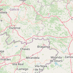
Montesinho Natural Park is a protected landscape in northeastern Portugal spanning 742 square kilometers across the municipalities of Vinhais and Bragança in the Bragança District. Established on August 30, 1979, the park encompasses a dramatic mountainous terrain that forms part of the Serra da Coroa mountain range, also known as the Sierra de la Culoebra, which runs along Portugal's border with Spain. The park rises from a minimum elevation of 438 meters to a maximum of 1,486 meters at the peak of Montesinho, creating a diverse altitudinal range that supports varied ecosystems and landscapes. Home to approximately 9,000 residents distributed across 92 traditional villages, the park represents one of Portugal's most sparsely populated and unspoiled natural areas, where human settlement patterns blend with rugged countryside. The protected area holds IUCN category V status, recognizing its value as a protected landscape where nature conservation coexists with sustainable human use and traditional rural communities.
Protected land status within the Bragança District of Portugal
Interactive boundary geometry and recorded spatial metrics
Mountain relief statistics and recorded physical features
Peaks
986 m
Streams
Rivers
Streams
Streams
Streams
Temperate broadleaf forest, riverine habitats, and Mediterranean climate zones
Mountains · Valleys · Forest · Woodland · Grassland · Rivers
Temperate broadleaf forest · Riverine habitat
Trace the geographic spread of protected areas, mountain ranges, and traditional landscapes surrounding Montesinho Natural Park.
Northwest

Exploring the river basins, granitic massifs, and ecological frontiers
The Área de Allariz biosphere reserve serves as a vital transition zone in northwestern Spain, characterized by its flat-floored tectonic basin, the River Limia, and varied highland terrain. This protected area offers an instructive look at the integration of traditional rural land management with large-scale ecological recovery and conservation across its core, buffer, and transition zones.
West

Granite peaks, glacial valleys, and cultural heritage mapped.
Peneda-Gerês National Park represents a cornerstone of protected landscapes in Portugal, celebrated for its rugged granite mountains and deep glacial valleys sculpted over millennia. This national park showcases a rare ecological transition zone with unique endemic species and features dramatic waterfalls and pristine river systems. The park's rich cultural tapestry, interwoven with its natural environment, offers a compelling subject for atlas-based geographic discovery and landscape exploration.
North
Mapping the Sierra de Ancares river valleys in Provincia de León
Examine the geographic layout and protected boundaries of the Reserva de la biosfera de los Ancares Leoneses. This biosphere reserve serves as a critical mountain corridor, featuring complex river basins and diverse forest cover that highlight the region's environmental and cultural history across the Spanish highlands.
Southwest
Discover dramatic landscapes and mapped terrain.
Alvão Natural Park is a protected area in northern Portugal distinguished by its stark geological contrasts: upper granite plateaus and steep schist lowlands. This unique geography supports diverse ecosystems and features the impressive Fisgas de Ermelo waterfall. Explore the park's mapped boundaries and its role as a significant protected landscape within the region, offering rich context for any geographic exploration.
North
Mountainous terrain and river valley geography in Lugo, Spain
This protected area covers the dramatic Sierra de Ancares, featuring steep mountain slopes and deep river valleys that define the geography of Galicia. The reserve spans a significant vertical relief, providing essential habitats for brown bears and capercaillie while preserving traditional rural mountain land use systems and ancient forest ecosystems.
Northwest
Extensive riverine forests and wetland networks in northwestern Spain
Explore the expansive territory of Reserva de la biosfera de las Tierras del Miño, spanning a large portion of the Galician interior. This protected area features a mosaic of wetlands, riparian corridors, and mountainous terrain, offering a deep look into the ecological and cultural geography of the upper Miño river basin.
Northwest
A diverse protected area across Galicia, Spain
This biosphere reserve serves as a vital ecological refuge along the Cantabrian-Atlantic coast. The protected area features a unique mosaic of marine and terrestrial habitats, ranging from rocky coastal cliffs and sandy estuaries to dense Atlantic forest fragments and the mountainous interior of the Sierra de la Cova da Serpe.
West
Mapped protected areas and regional landscape discovery near Esposende.
Uncover the geographic identity of Northern Littoral Natural Park, a key protected landscape situated near Esposende. This MoriAtlas entry focuses on its mapped boundaries and regional significance, providing a factual basis for understanding its role within Portugal's network of protected areas. Explore the park's natural terrain and its context within the broader geography of the Norte region for comprehensive atlas-based discovery.
Delve deeper into the atlas-driven discovery of Montesinho Natural Park. Understanding its precise geographic boundaries and protected landscape identity provides crucial context for exploring Portugal's natural areas. This MoriAtlas entry facilitates a structured approach to comprehending the park's place within its regional geography and the wider atlas of protected lands.