
Mori Atlas logo
Wildlife reserveMoutohora Island

Examine the rugged topography, geothermal terrain, and offshore ecological boundaries

Moutohora Island Wildlife Reserve: A Volcanic Landscape and Protected Marine Sanctuary

Moutohora Island stands as an eroded volcanic remnant off the Bay of Plenty coastline, rising with twin peaks and geothermal activity that define its unique geographical character. This wildlife reserve serves as a critical sanctuary for seabird colonies and regenerating forest ecosystems while providing a vital link to the surrounding marine environments. Its protected status maintains a mosaic of coastal terrain, cliffs, and active geothermal valleys that demonstrate complex geological evolution in New Zealand.

volcanic islandwildlife refugeseabird breedingmarine mammalsisland restorationBay of Plenty
A flat vector-style illustration of a mountainous volcanic landscape featuring a central waterfall flowing into a river, surrounded by pine forests and rolling hills under a soft sun.

Moutohora Island

Wildlife reserve

Park overview

Structured park overview, official facts, and landscape profile for Moutohora Island

Moutohora Island park facts, protected area profile, and essential visitor context

Review the core facts for Moutohora Island, including designation, size, terrain, visitor scale, habitats, and operating context in one park-focused overview.

About Moutohora Island

Moutohora Island is a compact but ecologically rich protected island lying offshore from Whakatāne in the Bay of Plenty. Geologically, it represents the surviving remnant of a complex Pleistocene volcano whose two peaks and rugged terrain reflect long-running erosion, while its Sulphur Valley, Sulphur Bay, and McEwans Bay still exhibit active geothermal activity in the form of hot springs. The island's character is shaped equally by its volcanic foundation and by the marine environment that surrounds it.

From a conservation perspective, Moutohora is one of the more important wildlife refuges along the Bay of Plenty coastline. Declared a wildlife refuge in 1965 and later purchased by the Crown in 1984, the island has been the focus of a sustained ecological restoration programme. After the removal of introduced goats, rats, cats, and rabbits, more than twelve thousand native plants representing around forty-five species were established, transforming degraded landscapes into a mosaic of pōhutukawa, māhoe, kānuka, bracken, and open grassland.

The island's significance extends to both avifauna and marine life. Moutohora supports one of New Zealand's significant breeding colonies of grey-faced petrels, along with sooty shearwaters, little blue penguins, and threatened shorebirds such as the New Zealand dotterel and variable oystercatcher. Surrounding waters host common and bottlenose dolphins, pilot whales, killer whales, seasonal migratory baleen whales, and occasional beaked whales, alongside sharks and a wide array of seabirds. The 1999 translocation of forty North Island saddlebacks (tīeke) from Cuvier Island added a culturally meaningful conservation chapter to the island's modern history.

Quick facts and research context for Moutohora Island

Moutohora Island is an uninhabited volcanic landmass lying roughly nine kilometres north of Whakatāne in New Zealand's Bay of Plenty. The island spans about 1.43 square kilometres and rises to a peak elevation of around 353 metres, forming the eroded remains of a Pleistocene complex volcano.

Declared a wildlife refuge in 1965 and purchased by the Crown in 1984, Moutohora is now administered with conservation involvement from local Ngāti Awa iwi and the New Zealand Department of Conservation. Public access is restricted to approved concession holders and scientific parties, helping preserve its seabird colonies, regenerating native vegetation, and surrounding marine life.

Protection and recognition

Examine the mixed protection scope and international recognition records for Moutohora Island.

Moutohora Island Protection Status and Designated Area Profile

Moutohora Island maintains a documented mixed protection scope, integrating varied conservation frameworks across its terrain. Verified records outline the baseline management parameters and administrative designations established for this protected landscape.

Protection details

Protection scope
Mixed
Transboundary protection
No
Park context

Deeper park guide and search-rich context for Moutohora Island

Moutohora Island history, landscape, wildlife, and travel context

Explore Moutohora Island through its history, landscape character, ecosystems, wildlife, conservation priorities, cultural context, and seasonal travel timing in a structured park guide built for atlas discovery and search intent.

Why Moutohora Island stands out

Moutohora is best known for its breeding colony of grey-faced petrels, set against a backdrop of regenerating native forest on an eroded volcanic island. The island's seabird life, combined with the surrounding presence of dolphins, whales, and sharks, makes it a notable site for both terrestrial and marine wildlife in the Bay of Plenty. The island is also recognised for its historical conservation significance: the eradication of introduced mammals and subsequent large-scale planting restored habitat for threatened species like the New Zealand dotterel and North Island saddleback, the latter reintroduced in 1999 as a symbolic continuation of traditional Māori migration stories linking the island to the wider Bay of Plenty region.
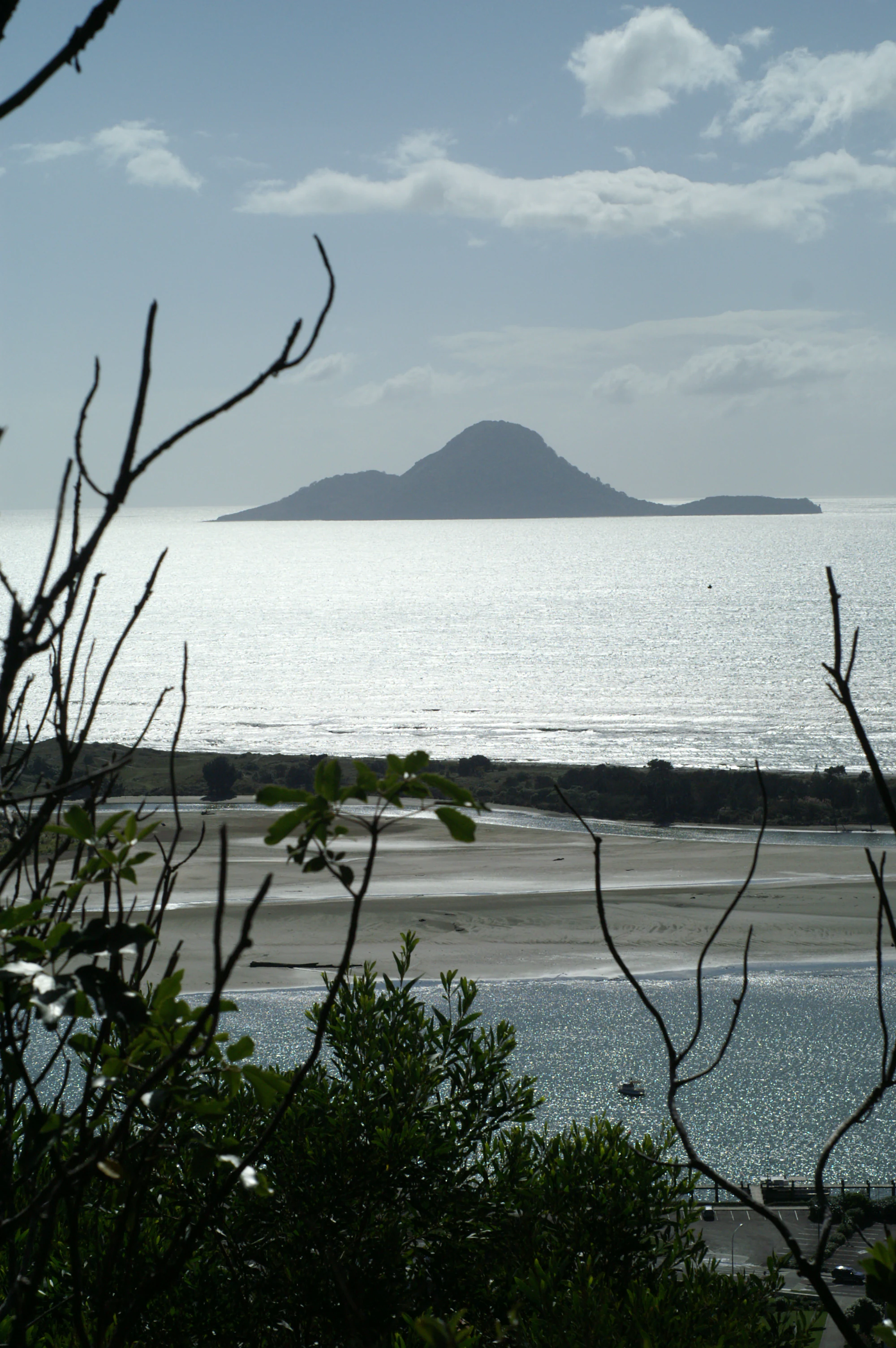
A view looking across a body of water toward the silhouette of Moutohora Island, framed by foreground tree branches.
A distant view of Moutohora Island from the coast.

Moutohora Island history and protected-area timeline

Moutohora Island carries a deep archaeological record, with numerous sites of both Māori and European origin documented across its terrain. These include an extensive pā (fortified earthworks) on Pa Hill, as well as house terraces, garden sites, midden deposits, stone tool manufacture areas, and stone walls. Although permanent Māori occupation ended in the early nineteenth century, Ngāti Awa and Tūhoe continued seasonal visits for seafood, sooty shearwaters, and stones used in hāngī cooking.

European activity began modestly in the 1830s with an unsuccessful attempt to establish a shore-based whaling station; no whales were ever taken. By the 1880s, sulphur extraction had begun, with product shipped to Auckland for refining. The sulphur proved to be of poor quality and the operation was abandoned in 1895. Quarrying then became the next industrial activity starting in 1915, supplying approximately twenty-six thousand tonnes of rock over five years for construction of the Whakatāne harbour wall.

The modern conservation era began in 1965 when Moutohora was declared a wildlife refuge. The Crown purchased the island in 1984, and, following the eradication of introduced mammals, a major restoration effort was launched. In March 1999, Ngāti Awa and the Department of Conservation collaborated to relocate forty North Island saddlebacks from Cuvier Island to Moutohora, an event that intentionally echoed traditional Māori stories of the Mataatua waka and the historical flight of tīeke.

Moutohora Island landscape and geographic character

Moutohora's landscape is dominated by its volcanic origins. The island is the eroded remnant of a complex volcano that once extended higher and broader across the surrounding seafloor. What remains are two main peaks reaching about 353 metres above sea level, separated by valleys and rugged slopes that descend to the coast. Hot springs remain active in several defined areas including Sulphur Valley, McEwans Bay, and Sulphur Bay.

The shoreline itself is varied, with cliffs, bays, and accessible coves that frame the island from different directions. Views from the nearby mainland, including the Kohi Point Walkway near Whakatāne, reveal a strikingly symmetrical volcanic silhouette when seen from certain angles. Inland, vegetation and topography together create a mosaic terrain that contrasts regenerating coastal forest, scrubby ridges, and open grassy areas, all set against the broader backdrop of mountainous North Island landscapes such as the distant Putauaki (Mt Edgecumbe).
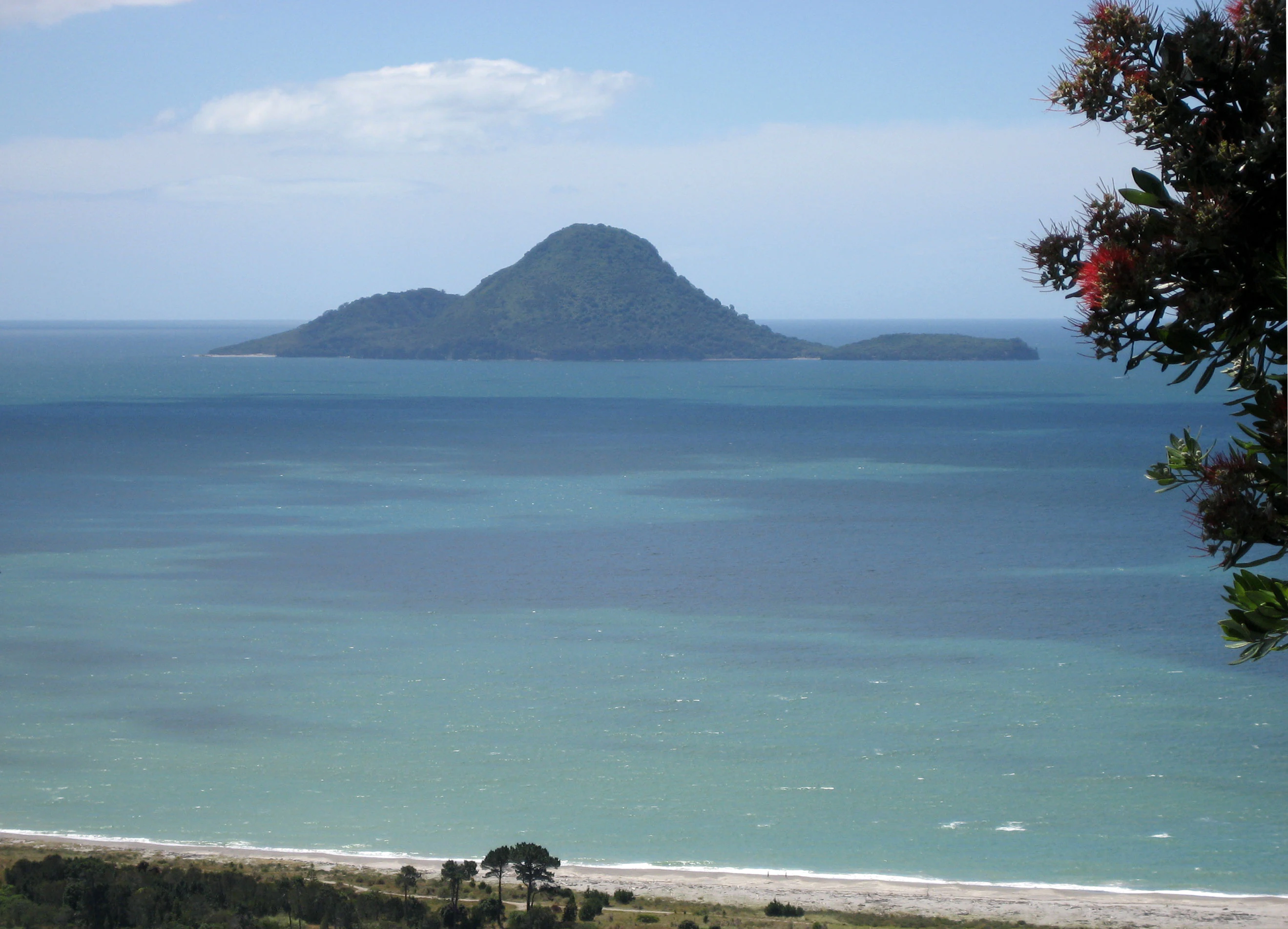
A distant volcanic island rises above a blue sea, framed by a flowering pohutukawa branch in the foreground.
Moutohora Island, also known as Whale Island, viewed across the water from the Bay of Plenty coastline.

Moutohora Island ecosystems, habitats, and plant life

The ecological identity of Moutohora is fundamentally shaped by its recovery from introduced species. Once grazed and disturbed by goats, rats, cats, and rabbits, the island has been progressively restored to a healthier ecological state through systematic pest eradication and replanting. More than twelve thousand plants representing around forty-five native species now form a vegetational mosaic covering the island. Dominant communities include pōhutukawa forest, māhoe stands, kānuka woodland, bracken, and open grassland.

Altogether, the island supports roughly 190 native plant species alongside about 110 introduced species, reflecting both active restoration and the lingering botanical footprint of past land use. The result is a landscape that, despite its small size, exhibits diverse microhabitats ranging from coastal fringe and regenerating broadleaf forest to more open scrub and grassland zones.

Moutohora Island wildlife and species highlights

Moutohora's fauna is dominated by seabirds, particularly its breeding colony of grey-faced petrels, which is among the most significant on the island. Sooty shearwaters, little blue penguins, variable oystercatchers, and the threatened New Zealand dotterel also breed here. Caspian terns, North Island kākā, and New Zealand falcon are recorded as occasional or seasonal visitors. Smaller fauna includes three lizard species and forest birds, with captive-bred red-crowned parakeets also present.

The surrounding marine environment adds a major wildlife dimension. Smaller cetaceans such as common and bottlenose dolphins, pilot whales, and killer whales are the most frequently recorded marine mammals, while larger migratory baleen whales, including southern right whales and rorquals, and occasional visits by toothed whales (including beaked whales) expand the marine biodiversity. New Zealand fur seals are also present, and the broader waters support sharks and a diverse oceanic bird fauna, creating an unusually rich combination of terrestrial and marine fauna for an island of this size.

Moutohora Island conservation status and protection priorities

Moutohora's conservation significance rests on its role as a recovered wildlife refuge in the Bay of Plenty. Protection began formally in 1965 with its declaration as a wildlife management reserve, and was reinforced when the Crown purchased the island in 1984. The subsequent eradication of introduced mammals and the replanting of more than twelve thousand native plants across multiple species represent one of the more intensive island restoration efforts on New Zealand's North Island coast.

The island plays an important role in the conservation of threatened species, including grey-faced petrels, New Zealand dotterels, and the reintroduced North Island saddleback. Marine conservation value is similarly high, with the surrounding waters forming part of an important habitat zone for cetaceans, sharks, seals, and seabirds. Co-management between Ngāti Awa and the Department of Conservation reflects a partnership approach that integrates ecological restoration with indigenous cultural stewardship.

Moutohora Island cultural meaning and human context

Moutohora carries strong cultural significance for local Māori, particularly Ngāti Awa, alongside historical connections with Tūhoe through seasonal resource use. The name 'Moutohorā' is itself a shortened form of 'Motutohorā', meaning 'Whale Island' or 'Captured Whale', a reference to the southern right whale (tohorā) and the area's long marine associations. Evidence of earlier permanent Māori settlement is preserved in pā, terraces, garden sites, storage pits, and other archaeological features.

The 1999 translocation of saddlebacks (tīeke) from Cuvier Island to Moutohora deliberately echoes the traditional story of the Mataatua waka, whose voyage was accompanied by two tīeke that briefly settled on the island. Access to Moutohora today is administered jointly through Ngāti Awa concession arrangements and the Department of Conservation, reflecting an ongoing partnership between iwi and the Crown in managing the island's cultural and natural heritage.

Top sights and standout views in Moutohora Island

Moutohora offers a rare combination of active volcanic geology, regenerating native forest, and abundant seabird and marine life within a compact offshore location. Its twin eroded volcanic peaks, lingering hot springs, and historic sites of Māori and European activity provide layered interest for visitors, researchers, and conservation observers.

Equally distinctive is the island's conservation trajectory, from nineteenth-century whaling and sulphur ventures to a modern sanctuary supporting grey-faced petrels, New Zealand dotterels, and reintroduced North Island saddlebacks, all set within a marine environment frequented by dolphins, whales, and sharks in the Bay of Plenty.

Best time to visit Moutohora Island

As a restricted-access conservation island, Moutohora is visited primarily through approved scientific parties and licensed concession holders rather than general tourism. For potentially eligible visitors, the calmer, drier months of the New Zealand late spring to early autumn tend to offer more favourable sea conditions around the Bay of Plenty and clearer weather for shoreline landings. Bird activity peaks during the seabird breeding season, while marine mammal sightings, including migrating baleen whales, can vary across the broader seasonal cycle. Visitors should expect that access may be further restricted during periods of high fire danger.

Monthly climate preview

Long-term representative records tracking monthly temperature and precipitation rhythm

Moutohora Island Climate Normals: Measured Annual Temperature and Precipitation Patterns

Moutohora Island records a measured annual temperature span alongside consistent monthly precipitation patterns derived from historical coordinate sampling. Accessing the complete twelve-month profile provides detailed meteorological data across every seasonal shift.
Annual mean14 °C
10 °C20 °C
Jan19°
Feb20°
Mar18°
Apr15°
May13°
Jun10°
Jul10°
Aug10°
Sep11°
Oct13°
Nov15°
Dec18°
Warmest month
February

19.6 °C

Coolest month
July

9.6 °C

Wettest month
July

3.9 mm/day

Driest month
November

2.2 mm/day

Park location guide

Geography guide, regional context, and park location map for Moutohora Island

Moutohora Island park geography, regions, and map view in New Zealand

Understand where Moutohora Island sits in New Zealand through a broader geographic reading of the surrounding landscape, nearby location context, and its mapped position within the national park landscape.

How Moutohora Island fits into New Zealand

New Zealand is an island nation in the southwestern Pacific Ocean comprising two main islands and numerous smaller islands. Located east of Australia across the Tasman Sea, it features varied topography with the Southern Alps running along the South Island and volcanic terrain on the North Island. The country was settled by Maori people between 1280 and 1350, followed by European exploration beginning in 1642, and became a Dominion in 1907 before gaining full independence in 1947.

Wider geography shaping Moutohora Island in New Zealand

New Zealand lies in the southwestern Pacific Ocean, east of Australia across the Tasman Sea. The country consists of two main islands, the North Island and South Island, plus over 600 smaller islands. The North Island features volcanic plateaus and hills while the South Island is dominated by the Southern Alps mountain range. The country has a long coastline and is surrounded by the Pacific Ocean.

Map view of Moutohora Island

Use this park location map to pinpoint Moutohora Island in New Zealand, understand its exact geographic position, and read its mapped placement within the surrounding landscape more clearly.

Pigeon | © OpenStreetMap contributors

Location context for Moutohora Island

Bay of Plenty

Visual exploration of protected terrain, regenerating forest habitats, and coastal wildlife refuges

Moutohora Island Photos and Volcanic Landscape Scenery

Photographic collections reveal the rugged volcanic terrain, steep shoreline cliffs, and geothermal valleys that define the island environment. Detailed visual records help observers examine the native forest regeneration, seabird habitats, and protected marine ecosystems surrounding the sanctuary.

A view looking across a body of water toward the silhouette of Moutohora Island, framed by foreground tree branches.

An aerial wide-angle view of the volcanic Moutohora Island surrounded by the open ocean, with a distant coastline visible on the horizon under a cloudy sky.

A distant volcanic island rises above a blue sea, framed by a flowering pohutukawa branch in the foreground.

Park atlas

Compare nearby coastal sanctuaries and volcanic island reserves across New Zealand

Parks Near Moutohora Island and Protected Areas in the Surrounding Region

Visitors exploring Moutohora Island can browse adjacent protected landscapes and coastal reserves across the Bay of Plenty. Comparing these regional habitats highlights broader patterns in island restoration and marine conservation.
Protected landscapeWaikato
About 125 km away#1 closest

Southwest

Pureora Forest Park: Ancient Rainforests and Protected Mountain Landscapes in Waikato

Regional geography and mapped native forest boundaries

Pureora Forest Park represents a significant protected area in the central North Island of New Zealand, defined by its towering podocarp giants and complex volcanic terrain. The park serves as a prime example of an intact rainforest ecosystem, featuring dense broadleaf canopies, deep river valleys, and significant remnants of ancient forest history. Its geography, shaped by both geological upheaval and centuries of growth, provides an essential record of the natural heritage preserved across the Waikato and Manawatu-Whanganui regions.

Area
759.57 km²
Established
1978
Relief
Mountain
Water
Major water bodies
A wide watercolor painting showing a calm body of water surrounded by soft, pastel-colored hills in shades of green, pink, and yellow.
Nature reserveNew Zealand
About 126 km away#2 closest

Northwest

Aldermen Islands Nature Reserve: Mapped Volcanic Geography and Coastal Forest Landscapes

Protected offshore wilderness in the Coromandel region

Discover the geographic structure of the Aldermen Islands, a cluster of rocky islets serving as an undisturbed nature reserve. These eroded lava domes and forested slopes represent a specialized ecosystem, offering a unique look at New Zealand coastal geography and volcanic remnant patterns situated in the waters off the Coromandel Peninsula.

Area
1.3 km²
Relief
Upland
Access
Highly restricted
Scope
Mixed
A minimalist watercolor painting of rolling hills and grassy landscape under a white background.
Protected areaManawatu-Whanganui Region
About 134 km away#3 closest

Southwest

Kaimanawa Forest Park: A Deep Dive into Protected Forest Terrain and Regional Mountain Geography

Remote backcountry wilderness within the Manawatu-Whanganui Region

Spanning the high country of the Rangitikei District, Kaimanawa Forest Park offers a vast, forested wilderness experience distinct from the surrounding volcanic cones. This atlas entry details the park's structural role as a protected conservation area, tracing its boundaries across rugged mountain ridges and deep valleys that define the heart of New Zealand's central North Island landscape.

Area
759.57 km²
Established
1969
Relief
Mountain
Climate
Temperate
A horizontal, minimalist watercolor painting showing stylized rolling hills in shades of light green, pale yellow, and soft pink against a white background.
Protected areaWaikato Region
About 148 km away#4 closest

Northwest

Coromandel Forest Park: Geography and Protected Area Overview in Waikato, NZ

Native bushland, valley systems, and conservation geography.

Coromandel Forest Park comprises an expansive system of forested hills and valleys covering the heart of the Coromandel Peninsula. This protected area features dense native ecosystems, ranging from the accessible Kauaeranga Valley to the ecologically significant southern blocks. Use this atlas perspective to understand the terrain, boundaries, and conservation value of this essential Waikato Region landscape.

Area
718.99 km²
Established
1971
Relief
Upland
Climate
Temperate
A watercolor painting showing soft, rolling green mountains and forest lines under a bright, light-filled sky.
Protected landscapeHawke's Bay
About 151 km away#5 closest

South

Kaweka Forest Park: Protected Landscape and Mountain Geography in Hawke's Bay

High-altitude alpine terrain and forest reserve mapping

Kaweka Forest Park represents a massive block of protected country in the central North Island, defined by the Kaweka Range and its prominent 1,724-metre summit. The landscape shifts from managed pine plantations to rugged, dissected mountain ridges, offering a unique study in New Zealand's interior geography, native ecological restoration, and geothermal features like the Mangatutu Hot Springs.

Area
594.26 km²
Established
1972
Relief
Mountain
Climate
Temperate
National parkNew Zealand
About 164 km away#6 closest

Southwest

Tongariro National Park: New Zealand's Premier Volcanic National Park Atlas

Explore mapped terrain, active volcanoes, and unique dual World Heritage values.

Tongariro National Park, situated in New Zealand's North Island, is a globally significant protected area celebrated for its dramatic volcanic landscapes and profound cultural heritage. As the nation's oldest national park, it features three active volcanoes: Mount Ruapehu, Mount Ngauruhoe, and Mount Tongariro, set within a diverse terrain that includes forests, alpine zones, and the Rangipo Desert. Its dual World Heritage status underscores its importance for both natural attributes and its sacred cultural landscape, offering rich opportunities for geographic and atlas exploration.

Area
795.96 km²
Established
1887
IUCN
II
Relief
Mountain
A wide, panoramic watercolor illustration showing layers of green rolling hills in the foreground, a line of green trees in the mid-ground, and soft purple and pink mountains in the background against a pale yellow sky.
Protected areaNew Zealand
About 165 km away#7 closest

West

Pirongia Forest Park: Mapped Geography and Protected Landscapes in the Waikato Region

Volcanic summits and native podocarp forest boundaries

Gain a deeper understanding of Pirongia Forest Park through its complex volcanic geology and dense native vegetation. This resource outlines the park's fragmented ridges, limestone stream systems, and its role as a biogeographic bridge within the Waikato landscape of New Zealand.

Area
167.7 km²
Established
1971
Relief
Mountain
Climate
Temperate
A soft watercolor illustration of green island peaks rising from a calm pinkish water surface against a light, hazy sky.
Nature reserveNew Zealand
About 170 km away#8 closest

Northwest

Mercury Islands Nature Reserve: Volcanic Landscapes and Protected Island Geography

A coastal island group off the Coromandel Peninsula, New Zealand

The Mercury Islands form a structured volcanic chain characterized by dramatic cliffs, sheltered coves, and critical pest-free ecosystems. This protected area holds international significance for its seabird colonies and the well-preserved archaeological sites associated with early Māori history across the islands.

Established
1769
Relief
Upland
Access
Remote access
Scope
Mixed

Common questions about visiting, size, designation, and location context for Moutohora Island

Moutohora Island FAQs for park facts, access, geography, and protected area context

Find quick answers about Moutohora Island, including protected-area facts, park geography, trail and visitor context, and how the park fits into its surrounding country and regional landscape.
MoriAtlas Explorer

Continue Your Protected Areas Search Across the Global Atlas

Deepen your exploration by continuing the structured search for national parks and protected areas worldwide. Utilize the comprehensive filtering capabilities to compare different conservation landscapes and refine your understanding of global park geography. Discover more about the distribution and characteristics of protected natural areas.

Global natural geography