Mori Atlas logo
Nature reserveNaturwald Kraxenbach

A large-scale nature reserve encompassing diverse spruce, beech, and fir ecosystems within the Chiemgauer Alps

Naturwald Kraxenbach Protected Forest: Mapping the Old Growth Montane Landscapes of the Bavarian Alps

Naturwald Kraxenbach spans over 1,800 hectares of protected montane woodland in southeastern Bavaria. This reserve preserves an intricate mosaic of low-elevation mixed forests and high-altitude larch stands along the Austrian border. By tracing its natural boundaries, you can study the ecological zonation of the Chiemgauer Alps and the preservation of old-growth stands that define this rugged mountain terrain.

mountain forestBavarian Alpsold-growth forestnature reserveNatura 2000mixed montane woodland

Naturwald Kraxenbach

Nature reserve

Park overview

Structured park overview, official facts, and landscape profile for Naturwald Kraxenbach

Naturwald Kraxenbach park facts, protected area profile, and essential visitor context

Review the core facts for Naturwald Kraxenbach, including designation, size, terrain, visitor scale, habitats, and operating context in one park-focused overview.

About Naturwald Kraxenbach

Naturwald Kraxenbach is one of Bavaria's most substantial recent additions to the state's network of protected natural forests. Situated in the Chiemgauer Alpen near the towns of Ruhpolding and Schneizlreuth, the reserve encompasses steep mountain terrain along the German-Austrian border. Its position within the broader Östliche Chiemgauer Alpen landscape connects it ecologically to a wider system of Alpine habitats that have long been valued for both their scenic and conservation significance.

The forest's official designation as a Naturwald in 2020 marked a formal commitment to allow natural forest development on a large scale. Unlike commercial forest areas, harvesting is restricted to essential forest protection and public safety measures. The Bayerische Staatsforsten, which administers the area, oversees the reserve under Article 12a of the Bavarian Forest Law. The reserve includes the older Naturwaldreservat Fischbach, which has been protected since 1998 and contains some of the oldest forest stands in the region.

Ecologically, the reserve represents a cross-section of montane forest types typical of the northern Alps. Lower areas support spruce forests with historical grazing influence, mid-elevations are dominated by mixed mountain forests of spruce, beech, and fir with scattered noble hardwoods such as sycamore maple, while the higher slopes near the border with Austria transition into larch-spruce communities. Multiple streams, including the Fischbach, Vorderer Kraxenbach, Mittlerer Kraxenbach, and Vorderer Steinbach, drain the area and contribute to its diverse forest microclimate.

Quick facts and research context for Naturwald Kraxenbach

Naturwald Kraxenbach is located in the Chiemgauer Alpen along the German-Austrian border, in the Bavarian municipalities of Ruhpolding and Schneizlreuth. It covers approximately 1,801 hectares and was officially designated as a Naturwald in 2020. The protected area is managed by the Bayerische Staatsforsten and falls under Article 12a of the Bavarian Forest Law, which governs Naturwaldreservate and Naturwaldflächen. The forest overlaps with the Natura 2000 site Östliche Chiemgauer Alpen and includes the older Naturwaldreservat Fischbach, established in 1998.

Protection and recognition

Documented terrestrial protection scope and international recognition data

Naturwald Kraxenbach Protection Status and Transboundary Geography

Naturwald Kraxenbach maintains a documented terrestrial protection scope spanning transboundary geography and conservation boundaries. Official records organize management scope, designation history, and international recognition sources into verified facts.

Protection details

Protection scope
Terrestrial
Transboundary protection
Yes
Park context

Deeper park guide and search-rich context for Naturwald Kraxenbach

Naturwald Kraxenbach history, landscape, wildlife, and travel context

Explore Naturwald Kraxenbach through its history, landscape character, ecosystems, wildlife, conservation priorities, cultural context, and seasonal travel timing in a structured park guide built for atlas discovery and search intent.

Why Naturwald Kraxenbach stands out

The park is best known for its extensive, permanently protected montane mixed forests, including mature spruce-beech-fir stands with noble hardwoods and high-elevation larch-spruce communities. The inclusion of the long-established Naturwaldreservat Fischbach, with stands over 200 years old, makes it one of the more significant old-growth mountain forest reserves in Bavaria. The presence of exceptionally tall holly trees, reaching up to 10 meters in height, is a particularly distinctive botanical feature of the area.

Naturwald Kraxenbach history and protected-area timeline

The area's modern conservation history began in 1998 with the establishment of the Naturwaldreservat Fischbach, a 314-hectare core zone designed to protect old-growth forest stands. Even before this designation, parts of the broader area had been set aside as 'Klasse-1-Wald' by the Bayerische Staatsforsten, withdrawing them from active timber management.

A major turning point came with the 2019 Bavarian citizens' initiative 'Artenvielfalt & Naturschönheit in Bayern' ('Biodiversity and Natural Beauty in Bavaria'). In response, the Bavarian state government announced that ten percent of state forest would be removed from active management. Naturwald Kraxenbach, formally designated in 2020, is one of the outcomes of this policy. The designation converted the previously restricted Klasse-1 areas into a fully protected Naturwald, ensuring permanent natural forest development for the entire 1,801-hectare area.

Naturwald Kraxenbach landscape and geographic character

The reserve occupies a section of the Chiemgauer Alpen characterized by steep, forested mountain slopes and deeply incised valleys. Prominent peaks in and adjacent to the area include the Sonntagshorn at 1,961 meters, the Dürrnbachhorn at 1,776 meters, and the Prügelbergkopf at 1,202 meters. The terrain transitions from mid-elevation montane forest zones to higher subalpine elevations close to the Austrian border.

Water plays a defining role in the area's landscape character. Streams such as the Fischbach, which forms the right upper course of the Weiße Traun, the Vorderer and Mittlerer Kraxenbach, and the Vorderer Steinbach, carve through the forest and shape moisture variation across the slopes. These watercourses contribute to the diverse microclimates that support the range of forest types found throughout the reserve.

Naturwald Kraxenbach ecosystems, habitats, and plant life

The ecological character of Naturwald Kraxenbach is defined by its zonation of montane forest types. At lower elevations, especially where historical grazing influenced the landscape, spruce-dominated forests prevail. Mid-elevations support classic Bergmischwald communities with a mix of Norway spruce, European beech, and silver fir, complemented by noble hardwoods such as sycamore maple.

Toward the Austrian border, the forest gives way to higher-elevation larch-spruce communities typical of more exposed subalpine settings. A botanical highlight of the reserve is its unusually tall holly (Stechpalme), with individual specimens reaching up to 10 meters in height and around 15 centimeters in diameter. The integration of the reserve into the larger Östliche Chiemgauer Alpen Natura 2000 network further strengthens its ecological connectivity and habitat value within the northern Alps.

Naturwald Kraxenbach conservation status and protection priorities

Naturwald Kraxenbach represents a significant conservation commitment in the Bavarian Alps. Officially designated in 2020 under Article 12a of the Bavarian Forest Law, the entire 1,801-hectare reserve is permanently withdrawn from timber production and dedicated to natural forest dynamics. Management is restricted to forest protection and necessary public safety measures, with no active harvesting permitted.

The reserve is embedded in the European Natura 2000 network as part of the Östliche Chiemgauer Alpen FFH site and the associated bird protection area. Inclusion of the older Naturwaldreservat Fischbach adds another layer of long-term protection, with some stands exceeding 200 years of largely uninterrupted development. This combination of statutory protection, ecological network integration, and old-growth forest value makes Kraxenbach one of the more ecologically significant forest reserves in Bavaria.

Top sights and standout views in Naturwald Kraxenbach

Naturwald Kraxenbach stands out for its combination of size, age, and ecological diversity within the Bavarian Alps. With more than 1,800 hectares under permanent protection, it offers a rare large-scale example of freely developing mountain forest in a region historically shaped by forestry.

The reserve's diverse altitudinal zonation, ranging from low-elevation spruce stands to high-elevation larch forests, and its notable holly specimens give it both ecological and botanical interest. Its integration with the Östliche Chiemgauer Alpen Natura 2000 network, along with the inclusion of the older Fischbach reserve, reinforces its role as a key node in the protected landscape of the Chiemgauer Alps.
Monthly climate preview

Long-term temperature ranges and precipitation averages recorded at reference elevation

Naturwald Kraxenbach Climate Normals and Monthly Weather Patterns

Naturwald Kraxenbach exhibits measured long-term temperature variations alongside distinct monthly precipitation averages derived from historical satellite data. Examining the complete twelve-month climatology profile reveals comprehensive annual weather patterns across the representative protected coordinate.
Annual mean5 °C
-5 °C15 °C
Jan-5°
Feb-4°
Mar
Apr
May
Jun13°
Jul15°
Aug14°
Sep10°
Oct
Nov
Dec-4°
Warmest month
July

14.5 °C

Coolest month
January

-4.8 °C

Wettest month
July

6.2 mm/day

Driest month
February

2.6 mm/day

Park location guide

Geography guide, regional context, and park location map for Naturwald Kraxenbach

Naturwald Kraxenbach park geography, regions, and map view in Germany

Understand where Naturwald Kraxenbach sits in Germany through a broader geographic reading of the surrounding landscape, nearby location context, and its mapped position within the national park landscape.

How Naturwald Kraxenbach fits into Germany

Germany is a federal republic in Western and Central Europe with a population of over 83 million across sixteen constituent states. It is Europe's largest economy by nominal GDP and a major global exporter and importer. The capital is Berlin, and the country borders Denmark, Poland, Czech Republic, Austria, Switzerland, France, Luxembourg, Belgium, and the Netherlands.

Wider geography shaping Naturwald Kraxenbach in Germany

Germany is located in Western and Central Europe, spanning 357,022 km². It borders Denmark to the north, Poland and the Czech Republic to the east, Austria and Switzerland to the south, and France, Luxembourg, Belgium, and the Netherlands to the west. The country has coastlines on the Baltic Sea and North Sea to the north, with the Alps located in the southern region.

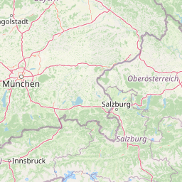
Map view of Naturwald Kraxenbach

Use this park location map to pinpoint Naturwald Kraxenbach in Germany, understand its exact geographic position, and read its mapped placement within the surrounding landscape more clearly.

Pigeon | © OpenStreetMap contributors
Park atlas

Compare regional mountain forests and connected protected areas across the Bavarian Alps.

Explore Other Parks Near Naturwald Kraxenbach and Surrounding Protected Landscapes

Browsing nearby national parks and adjacent forest reserves helps place Naturwald Kraxenbach within the wider ecological context of the Chiemgauer Alps. Comparing surrounding protected landscapes reveals shared terrain features, transitional montane zones, and regional conservation patterns.
Watercolor illustration showing mountain ranges, forests, and a river under a light sky.
National parkBavaria
About 11 km away#1 closest

Southeast

Berchtesgaden National Park: Protected Landscape and Regional Geographic Context in Bavaria

Mapped natural terrain and protected area exploration.

Berchtesgaden National Park represents a crucial protected landscape situated in Bavaria, Germany. This entry provides detailed information focused on its protected area status, unique geographic setting, and mapped natural terrain. It serves as a gateway to understanding the park's specific identity within the regional atlas of Germany, offering insights into its boundaries and its significance as a curated natural landscape for discovery.

Area
210 km²
Established
1978
IUCN
II
Relief
Mountain
A pale, minimalist watercolor illustration of layered mountain silhouettes in the background and a green, forested foreground.
Nature reserveTyrol
About 33 km away#2 closest

Southwest

Kaiser Mountains Nature Reserve: Alpine Limestone Landscapes and Regional Geography in Tyrol

A comprehensive look at the Wilder Kaiser and Zahmer Kaiser ridges

The Kaiser Mountains stand as a monumental feature within the Northern Limestone Alps. This nature reserve offers a unique geographic profile, from sheer, pale Wetterstein limestone walls to broad alpine pastures and pine-covered ridges. Its radial drainage patterns and self-contained massif structure provide an essential case study for understanding the diverse mountain terrain that defines the heart of the Austrian Tyrol.

Area
102 km²
Established
1963
Relief
Mountain
Climate
Alpine
National parkAustria
About 52 km away#3 closest

South

Hohe Tauern National Park: Regional Geography and Protected Alpine Mountain Terrain

Major protected area in the heart of the Austrian Alps

Hohe Tauern National Park protects a grand scale of alpine terrain, including towering summits above 3,000 meters and the longest glacial systems in the country. This atlas record provides insights into the park's vertical landscape, encompassing glacial valleys, waterfalls, and diverse ecological zones that define the High Tauern mountain range in Austria.

Watercolor painting showing mountain ranges with green, yellow, and pink hues, depicting layered peaks and cloud formations
National parkAustria
About 68 km away#4 closest

South

Hohe Tauern National Park: Alpine Geography and Protected Landscape Atlas

High-altitude mountain terrain and glacial systems in Austria

Hohe Tauern serves as a primary protected area within the Austrian Alps, showcasing a vast sequence of glacial valleys, sharp mountain massifs, and high-alpine tundra. This exploration details the park's physical boundaries and its significance in preserving diverse ecological gradients and wilderness core zones across the Central Eastern Alps.

Area
1,806 km²
Established
1981
IUCN
II
Relief
Mountain
A soft watercolor illustration showing a panoramic view of mountain ridgelines in muted green, blue, and faint pink tones against a white background.
Nature reserveSalzkammergut
About 81 km away#5 closest

East

Loser Plateau Nature Reserve: Alpine Karst Geography in the Salzkammergut Mountain Range

Protected high alpine plateau and extensive karst systems

The Loser Plateau is a distinctive high-altitude nature reserve in the Salzkammergut region of Austria. This protected area features expansive limestone pavements, complex karst sinkholes, and massive mountain crags that dominate the skyline above Lake Altaussee. It provides a unique window into high alpine geology, showcasing fossil-rich layers and an intricate network of documented cave systems that rank among the most significant in the Eastern Alps.

Area
12 km²
Relief
Mountain
Climate
Alpine
Access
Easy access
A horizontal watercolor illustration of a landscape with green pine trees in the foreground, a pale yellow meadow, and soft purple and green rolling mountains in the background against a white background.
Nature reserveBavaria
About 100 km away#6 closest

West

Schellenbergmoor Nature Reserve: Geographic Mapping of Bavarian Pre-Alpine Wetland Landscapes

Protected peatland terrain in the Tölzer Moorachse corridor

Schellenbergmoor functions as a protected nature reserve situated in the pre-Alpine hill and moorland zone of Upper Bavaria. This site preserves rare raised and transitional bog habitats, serving as a critical node for hydrology and ecosystem connectivity between Lake Starnberg and the Loisach river basin.

Established
1987
A horizontal watercolor illustration showing a winding stream moving through a flat marshy landscape with scattered trees and distant rolling hills.
Nature reserveBavaria
About 108 km away#7 closest

Northwest

Schwarzhölzl Nature Reserve: Protected Lowland Peatland and Forest Geography in Bavaria

Essential protected area map and habitat overview

Schwarzhölzl is a specialized nature reserve in Bavaria protecting a rare mosaic of peat birch forest, bog pines, and wet meadows. As an ecological remnant of the vast Dachauer Moos, this site provides a deep look into the lowland wetland terrain and the specific conservation landscape managed within the Munich green belt. Explore the mapped boundaries and structural geography of this significant protected lowland site.

Area
0.795 km²
Established
1994
Relief
Lowland
Climate
Temperate
Watercolor painting depicting layered mountain ranges, forests, and water bodies in green and pink tones
National parkUpper Austria
About 112 km away#8 closest

East

Kalkalpen National Park: Ancient Beech Forests and Karst Protected Landscape

Explore mapped boundaries and unique alpine terrain.

Kalkalpen National Park is a premier protected area in Upper Austria, celebrated for harboring Central Europe's largest remaining ancient beech forests and an extensive karst landscape. This designation underscores its critical role in preserving old-growth forest ecosystems and unique geological formations within the Northern Limestone Alps. Discover the mapped terrain and regional geography that define this significant natural reserve, offering a profound look into the continent's ecological history and protected natural heritage.

Area
208.25 km²
Established
1997
IUCN
II
Relief
Mountain

Common questions about visiting, size, designation, and location context for Naturwald Kraxenbach

Naturwald Kraxenbach FAQs for park facts, access, geography, and protected area context

Find quick answers about Naturwald Kraxenbach, including protected-area facts, park geography, trail and visitor context, and how the park fits into its surrounding country and regional landscape.
MoriAtlas Explorer

Continue Your Protected Areas Search Across the Global Atlas

Deepen your exploration by continuing the structured search for national parks and protected areas worldwide. Utilize the comprehensive filtering capabilities to compare different conservation landscapes and refine your understanding of global park geography. Discover more about the distribution and characteristics of protected natural areas.

Global natural geography