
Mori Atlas logo
National parkNelson's Dockyard National Park

Explore the intersection of Georgian maritime heritage and protected coastal ridges in southern Antigua

Nelson's Dockyard National Park: A Comprehensive Geographic Atlas of Protected Caribbean Landscapes

Nelson's Dockyard National Park stands as a rare protected landscape that seamlessly integrates the world's only continuously working Georgian-era naval facility with the surrounding Caribbean coastal terrain. This park encompasses the deep, sheltered inlet of English Harbour and the adjacent dry forest hills, providing a unique look at how 18th-century naval infrastructure exists within a modern protected island ecosystem. The area serves as a primary reference point for understanding the maritime geography, ridge-line defences, and coastal ecology of southern Antigua.

historic dockyardGeorgian architecturemaritime heritageCaribbean coastEnglish Harbournational park
Digital vector-style illustration of a harbor with sailboats, yachts, and a stone pier in the foreground, with a dramatic waterfall cascading down green cliffs in the background.

Nelson's Dockyard National Park

National park

Park overview

Structured park overview, official facts, and landscape profile for Nelson's Dockyard National Park

Nelson's Dockyard National Park park facts, protected area profile, and essential visitor context

Review the core facts for Nelson's Dockyard National Park, including designation, size, terrain, visitor scale, habitats, and operating context in one park-focused overview.

About Nelson's Dockyard National Park

Nelson's Dockyard National Park occupies a unique place among national parks in the Caribbean. Rather than protecting a vast wilderness, it wraps around English Harbour, one of the most strategically valuable natural harbours in the Leeward Islands, and centres on a restored British naval dockyard whose origins stretch back to the early 18th century. The park is small in geographical extent compared with most national parks, but its combination of cultural heritage, natural setting, and recreational use gives it an unusual layered identity.

The harbour itself is the park's defining geographic feature. A narrow, sheltered inlet on the south coast of Antigua, English Harbour offered the Royal Navy a safe base from which to monitor neighbouring French and Spanish possessions and from which Caribbean trade convoys could be supported. The landscape around the dockyard is typical of southern Antigua: dry forested hills, low ridges, and coastal scrub that tumble down toward a deep blue natural bay. Trails that begin near the marina lead visitors into this surrounding terrain, making the park just as much a place for short hikes and viewpoints as for maritime history.

At its cultural core, the park preserves a complex of late 18th- and early 19th-century dockyard buildings, including the Copper and Lumber Store, the Canvas, Cordage and Clothing Store, the Mast Houses, the Engineer Offices, and the former Pitch and Tar Store, now the Admiral's Inn. Two hotels, a dockyard museum, restaurants, and craft shops occupy some of the historic buildings, while a large modern marina fills part of the original waterfront. Together they make the dockyard a rare example of a Georgian naval base that has not only survived but remains economically active as a centre for yachting, regattas, and charter operations.

Recognition of the site's exceptional value came when it was inscribed, along with related archaeological remains around Antigua's coastline, as the UNESCO Antigua Naval Dockyard and Related Archaeological Sites World Heritage Site. That designation underlines how the national park functions simultaneously as a maritime museum, a working harbour, a community of vessels and visitors, and a piece of Caribbean nature.

Quick facts and research context for Nelson's Dockyard National Park

Nelson's Dockyard National Park sits within English Harbour on the south coast of Antigua, the larger of the two islands that make up the Caribbean state of Antigua and Barbuda. It encompasses both the historic Georgian naval dockyard and the surrounding hills and shoreline that frame the natural harbour.

The dockyard at its centre was developed by the British Royal Navy beginning in the early 1700s and abandoned in 1889. After decades of decay, the Society of the Friends of English Harbour began restoration in 1951 and the dockyard reopened to the public in 1961. The park today functions as a cultural heritage site, a marina, a yachting venue, and a protected natural area, and it is part of the Antigua Naval Dockyard and Related Archaeological Sites UNESCO World Heritage Site.

Protection and recognition

Examine the documented protection status and management scope for Nelson's Dockyard National Park.

Nelson's Dockyard National Park Protection Status and Designation Records

Nelson's Dockyard National Park maintains a documented mixed protection status reflecting its established geographic conservation framework. Review the recorded management scope and available international recognition details for this protected area.

Protection details

Protection scope
Mixed
Park context

Deeper park guide and search-rich context for Nelson's Dockyard National Park

Nelson's Dockyard National Park history, landscape, wildlife, and travel context

Explore Nelson's Dockyard National Park through its history, landscape character, ecosystems, wildlife, conservation priorities, cultural context, and seasonal travel timing in a structured park guide built for atlas discovery and search intent.

Why Nelson's Dockyard National Park stands out

Nelson's Dockyard National Park is best known for housing the world's only continuously working Georgian-era naval dockyard. The complex of restored stone storehouses, mast houses, officers' quarters, capstan houses, and boat-house pillars is a remarkably intact example of British colonial naval architecture from the period around Horatio Nelson's posting to Antigua between 1784 and 1787, after whom the dockyard is named. Equally distinctive is the way the heritage dockyard is integrated into a Caribbean national park. Hiking trails fan out from the marina into the surrounding landscape, linking the cultural heart of the site to the broader hills, dry forests, and coastline that characterise southern Antigua. The park blends Georgian maritime heritage with tropical scenery and is also recognised internationally through its inclusion in the Antigua Naval Dockyard UNESCO World Heritage Site.
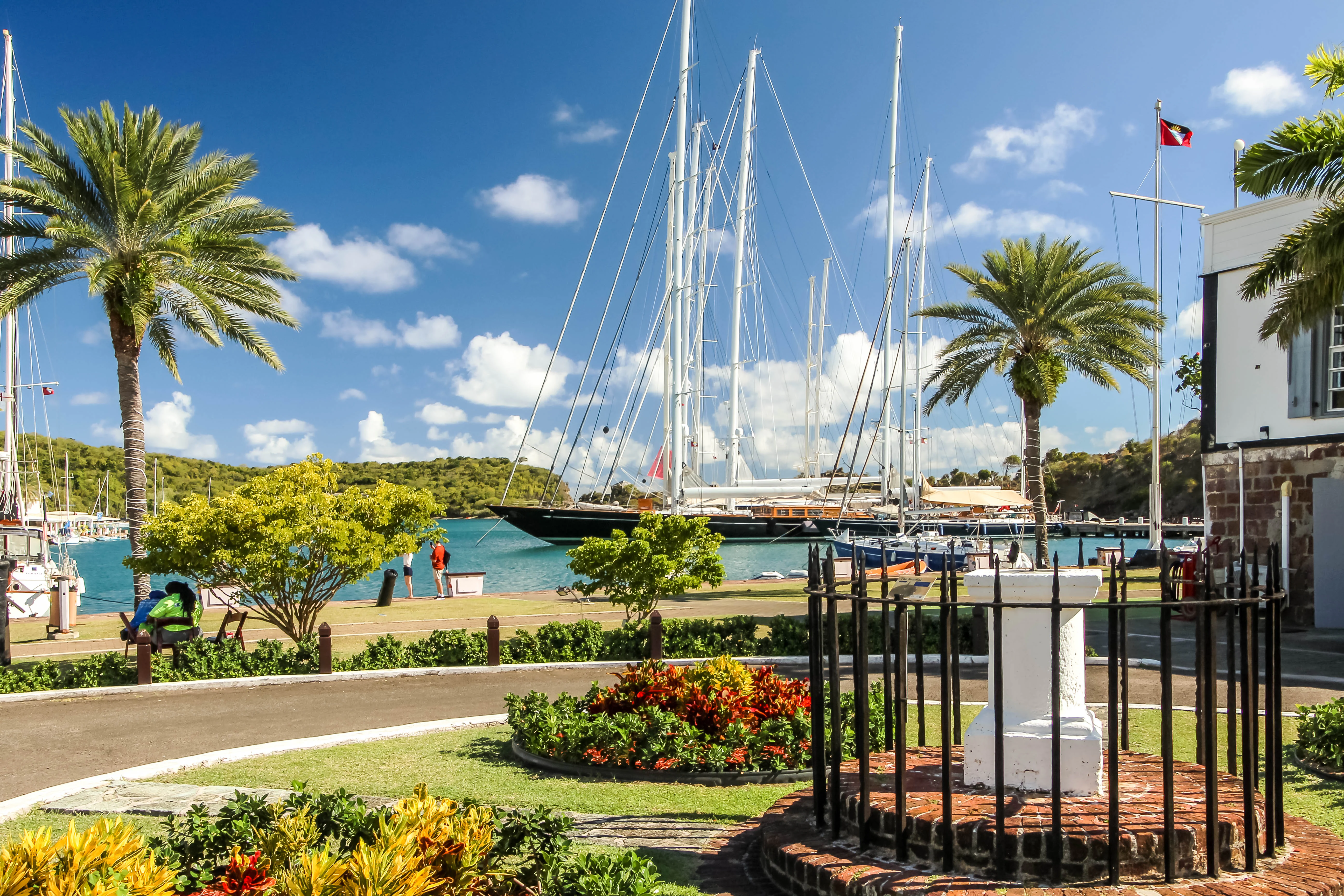
A sunny view of English Harbour with a large sailing yacht docked, palm trees, and historic stone architecture in the foreground.
A scenic view of the historic Nelson's Dockyard in English Harbour, Antigua.

Nelson's Dockyard National Park history and protected-area timeline

The history of Nelson's Dockyard National Park is the history of English Harbour as a British naval base. English colonists began using Antigua in 1632, and the Royal Navy soon recognised the harbour's value thanks to its sheltered position, deep water, and natural protection from hurricanes. Formal defensive work began around 1704, when Fort Berkeley was listed among Antigua's coast-defence forts, and by 1707 English Harbour served as a regular station for Royal Navy ships, although there were still no proper facilities for repair and maintenance.

In 1723 the harbour proved its worth during a hurricane that wrecked thirty-five ships elsewhere on Antigua but left vessels moored in English Harbour unharmed. Naval officers pressed for permanent dockyard facilities, and from 1725 onwards a series of expansions transformed the site. A first small yard on the eastern shore, called St Helena, was soon outgrown, and in the mid-1740s construction of the present Naval Dockyard began on the western side, carried out in significant part by enslaved Africans drawn from local plantations. Over the following decades the dockyard grew rapidly: storehouses, offices, barracks, mast houses, defensive walls, hospitals, water-catchment systems, and reclamation works for wharves were added in phases through the 1750s, 1760s, 1770s, and 1780s.

The most famous era of the dockyard overlaps with Horatio Nelson's command in the Caribbean. Nelson lived in the dockyard from 1784 to 1787, and the building programme of 1785 to 1794, including the Engineer Offices, the Pitch and Tar Store, and the Copper and Lumber Store, dates from around and just after his tenure. The Sail Loft and Boat House went up in 1797, and further officers' quarters and administrative buildings followed in the early 19th century, the Naval Officer's and Clerk's House of 1855 eventually becoming the present-day Dockyard Museum.

The Royal Navy abandoned the dockyard in 1889 and the site was left to decay for more than half a century. Restoration began in 1951 under the Society of the Friends of English Harbour, and in 1961 the dockyard reopened to the public as a heritage site with new cultural and commercial uses. The later recognition of the dockyard and its related coastal fortifications as part of a UNESCO World Heritage Site, and its incorporation into Nelson's Dockyard National Park, cemented its transition from an active military base to a protected cultural and natural landscape.

Nelson's Dockyard National Park landscape and geographic character

The landscape of Nelson's Dockyard National Park is shaped by the deep, narrow inlet of English Harbour on Antigua's southern coast. The harbour is naturally enclosed by headlands and low ridges, which protect the water from wind and swell and historically made it one of the most reliable hurricane shelters in the Caribbean. Surrounding the water is a frame of dry, rolling hills typical of Antigua's south side, cloaked in low scrub, dry forest, and coastal vegetation that thrives in the seasonal tropical climate.

The built landscape of the dockyard occupies the flat ground of the western waterfront. Stone storehouses, timber-framed sheds, and masonry offices stand shoulder to shoulder along reclaimed land at the water's edge, with the surviving pillars of the former Boat House and Sail Loft rising out of the ground as a reminder of the original naval architecture. Beyond the dockyard walls, the parkland extends up into hills that offer elevated viewpoints over the harbour and out toward Freemans Bay and the open Caribbean.

Coastal scenery is central to the park's sense of place. Short trails climb toward lookouts such as Fort Hill, from which the whole sweep of English Harbour and the dockyard can be taken in, while other paths wind through dry woodland and past former military positions associated with the harbour's defence. The combination of compact historic waterfront, working marina, dramatic cliff-edged bay, and forested ridge above defines what makes the park feel distinct from a purely cultural site.
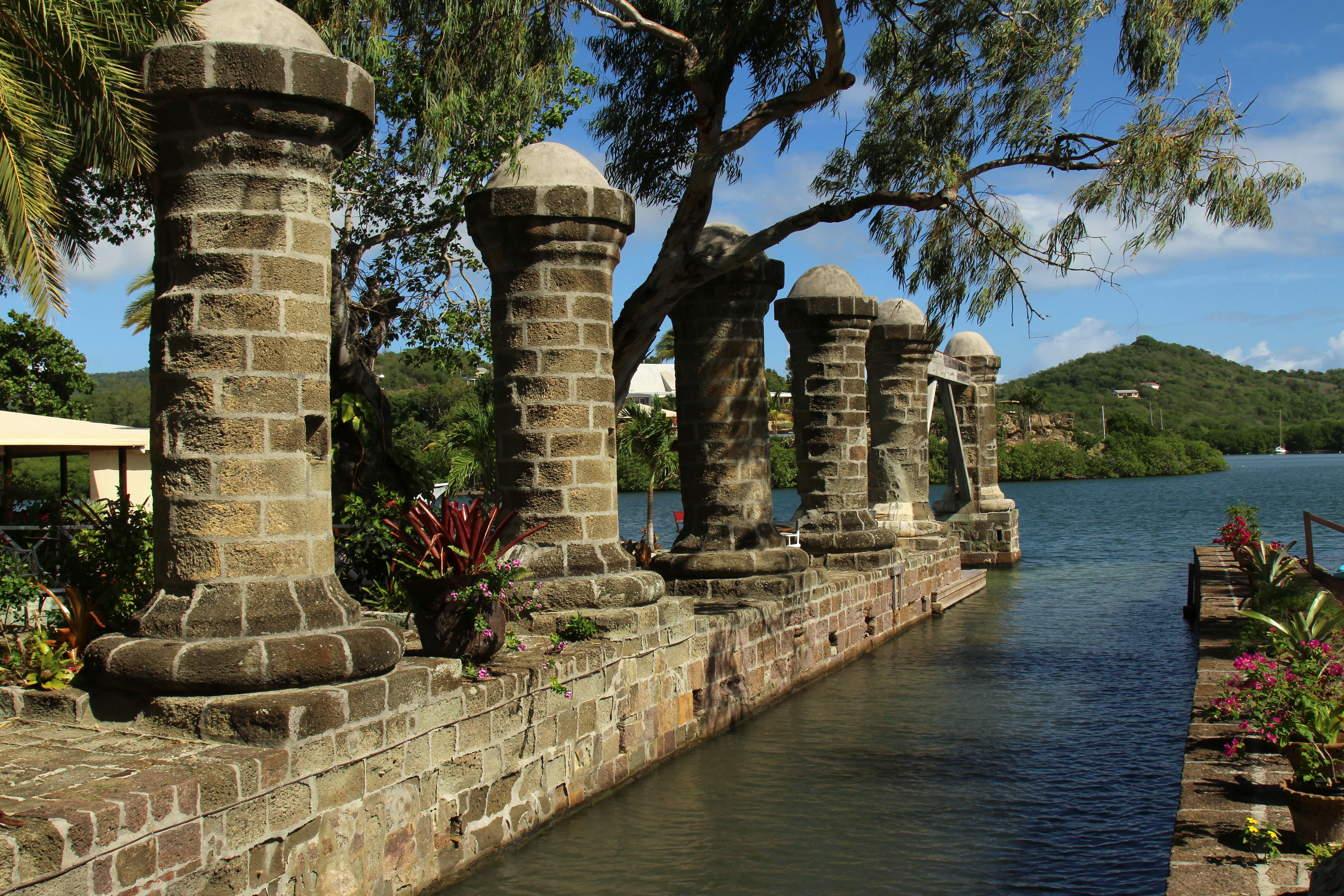
A row of stone pillars stands along a harbor wall at Nelson's Dockyard, with blue water and green hills visible in the background.
Historic stone pillars line the waterfront at Nelson's Dockyard in English Harbour.

Nelson's Dockyard National Park ecosystems, habitats, and plant life

Although the national park is best known for its built heritage, its natural setting is integral to its identity. The hills around English Harbour support a characteristically Antillean dry forest ecosystem, with low trees, scrubby understorey, succulents, and hardy coastal plants adapted to thin limestone soils and a climate with a pronounced dry season. This vegetation is typical of the leeward side of Antigua and Barbuda, where moisture levels are lower than in the mountainous interior of many other Lesser Antillean islands.

The harbour itself is a sheltered marine environment, and its calm waters explain why the site was chosen as a naval base long before any formal dockyard existed. Mangroves and salt-tolerant shoreline plants fringe parts of the inlet, while the open water hosts a mix of resident and visiting marine life typical of the south coast of Antigua. Birdlife associated with coastal scrub and cliff edges is a regular feature, and visitors walking the park's trails often see species typical of Caribbean dry-forest habitats.

Because the park is small in extent and heavily visited through the dockyard and marina, its natural areas function more as scenic and ecological surroundings to the heritage core than as large intact wilderness. That framing gives the park a distinctive balance: nature here is experienced in compressed form, intertwined with stone walls, historic buildings, and the working harbour rather than standing apart from them.
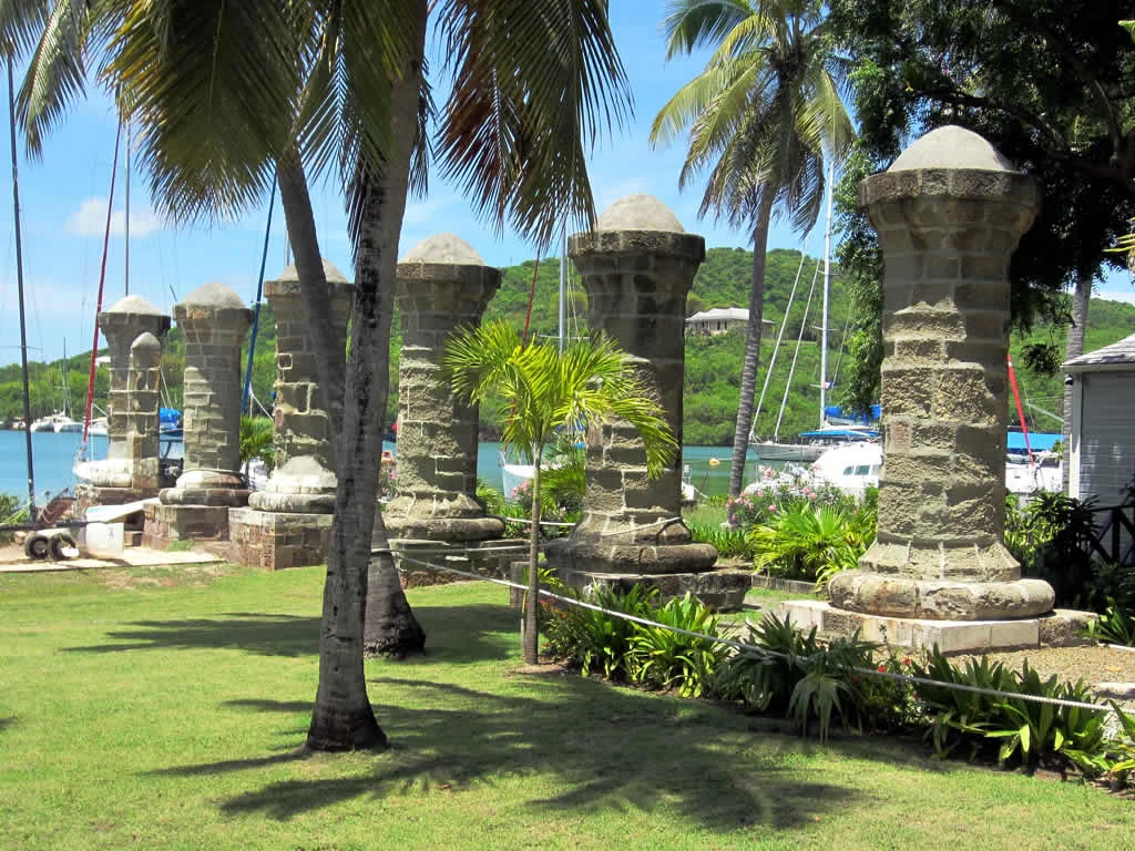
A row of several tall, weathered stone columns with rounded caps standing in a grassy area at Nelson's Dockyard in Antigua, with palm trees and sailboats visible in the background.
Historical stone pillars remaining from the boat house at Nelson's Dockyard.

Nelson's Dockyard National Park wildlife and species highlights

Wildlife within Nelson's Dockyard National Park is closely tied to its coastal and dry-forest habitats. The surrounding hills and clifftops provide habitat for land birds typical of Antigua's south coast, including both resident species and seasonal Caribbean migrants. Walking trails out of the dockyard are a common setting for casual birdwatching, with views that include both forested ridge habitat and the open sky above the harbour, where seabirds are regularly seen.

The marine ecology of English Harbour, while not the focus of the site's fame, supports the recreational fishing, sailing, and yachting culture that the dockyard now hosts. The protected waters shelter a range of reef and pelagic fish species associated with the southern Leeward Islands. Historic records of the dockyard itself describe provisions for the care and feeding of animals used in naval logistics, and the site retains an everyday working-horse-and-maritime character that visitors encounter at the marina.

The park's wildlife significance lies less in headline species counts and more in the way a functioning Caribbean harbour ecosystem coexists with a major heritage site. Visitors interested in natural history tend to experience the park's fauna as a closely woven background to the dockyard, the hills, and the shoreline, rather than as a standalone attraction.
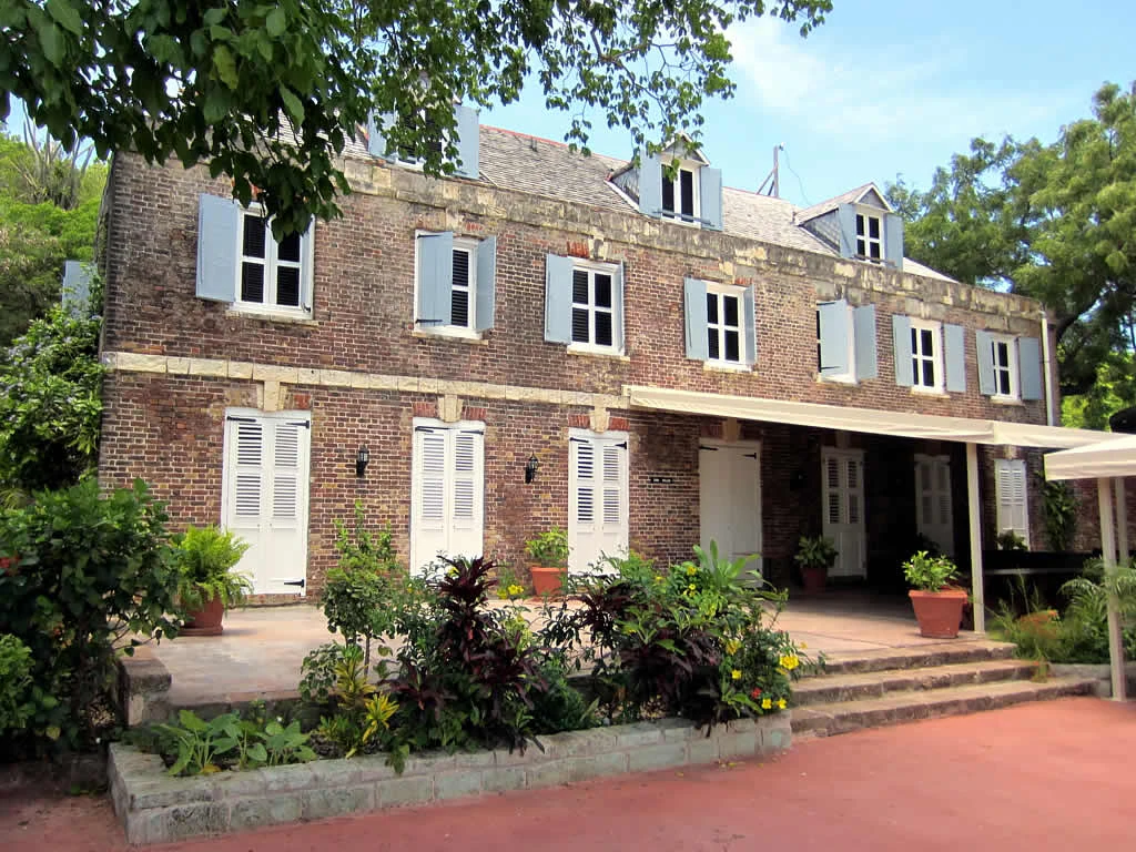
Exterior view of a three-story brick historic building with white window shutters and potted plants on a stone patio.
The Admiral's Inn at Nelson's Dockyard, a historic 18th-century structure currently serving as a hotel.

Nelson's Dockyard National Park conservation status and protection priorities

Conservation framing of Nelson's Dockyard National Park is unusual because the park's primary reason for protection is cultural heritage supported by natural setting, rather than a large natural wilderness. The dockyard complex is protected both as a national park and as part of the Antigua Naval Dockyard and Related Archaeological Sites UNESCO World Heritage Site, which encompasses related fortifications and archaeological features along Antigua's coast.

Within this heritage framework, conservation efforts focus on preserving Georgian-era naval architecture, original dockyard layouts, defensive structures such as Fort Berkeley, and the surrounding hillsides and viewpoints that give the site its sense of place. Restoration work begun in 1951 by the Society of the Friends of English Harbour set a long-running pattern of preservation that continues under modern management of the national park, including ongoing maintenance of historic buildings and gradual management of vegetation around the historic core.

The park also illustrates a model of conservation in which heritage protection, tourism, and active marine use are combined. By maintaining a working marina, hosting sailing events, and integrating hotels, restaurants, and museums into original dockyard buildings, the park keeps the maritime infrastructure alive while ensuring that the historic fabric is regularly inhabited and cared for, rather than left as an abandoned relic.

Nelson's Dockyard National Park cultural meaning and human context

Nelson's Dockyard National Park reflects the layered cultural history of Antigua and Barbuda. The site was shaped by British colonial power, the Royal Navy's role in the Caribbean, and the labour of enslaved Africans from local plantations who built many of the surviving structures. The dockyard stands as a tangible reminder of how the Caribbean islands were contested and administered by European empires in the 18th and 19th centuries.

Horatio Nelson's residence at the dockyard between 1784 and 1787 anchors the site firmly in the popular memory of British naval history. Nelson's presence during a major construction phase means that several of the buildings most closely associated with the dockyard, including the Engineer Offices and the Pitch and Tar Store, were built in and around his tenure. The dockyard's name honours this connection.

Modern cultural life within the park is vibrant and international. Sailing and yachting events such as Antigua Sailing Week, the Antigua Classic Yacht Regatta, and the Antigua Charter Yacht Meeting, as well as youth regattas like the North American Optimist Championships, draw participants and visitors from around the world. Restaurants, hotels, museums, and craft shops inside the dockyard buildings give the park a living communal character, while surrounding hiking trails connect visitors to the broader Antiguan landscape.
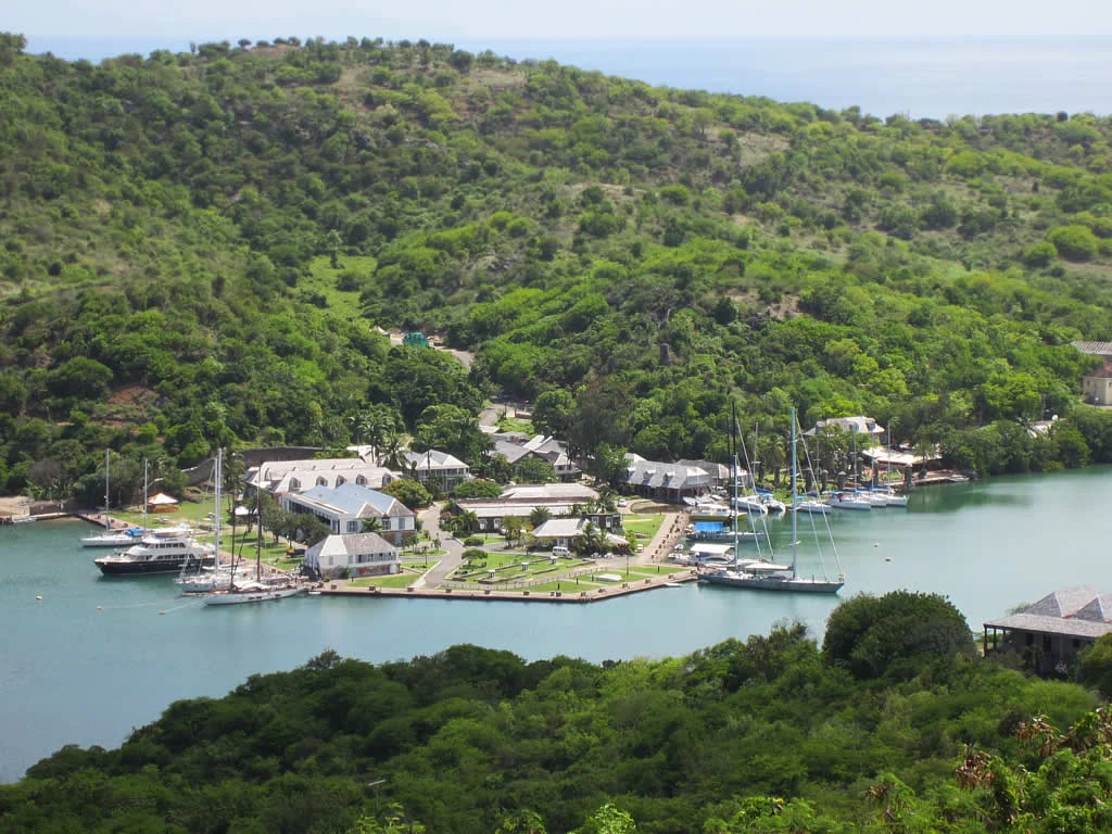
A high-angle view of a historic maritime facility with colonial-style buildings along a harbor waterfront, surrounded by lush green hills and anchored yachts.
An aerial view of the historic Nelson's Dockyard nestled within the hills of English Harbour.

Top sights and standout views in Nelson's Dockyard National Park

Nelson's Dockyard National Park offers a rare combination of Georgian naval architecture, a working Caribbean marina, and easily accessible dry-forest hillside trails, all compressed into a single protected site on Antigua's south coast. Highlights include the surviving stone storehouses and Mast Houses around the marina, the open-air pillars of the original Sail Loft and Boat House, and the panoramic viewpoints looking down over English Harbour from the surrounding ridges.

Equally central to the park's appeal are its living maritime traditions. Antigua Sailing Week, the Classic Yacht Regatta, and the Charter Yacht Meeting turn the dockyard into a focal point for Caribbean yachting each year, while ongoing restoration and adaptive reuse of original buildings keep the historic fabric in active use. Trails that radiate from the dockyard into the surrounding national park extend the experience into nature without requiring long travel from the harbour.
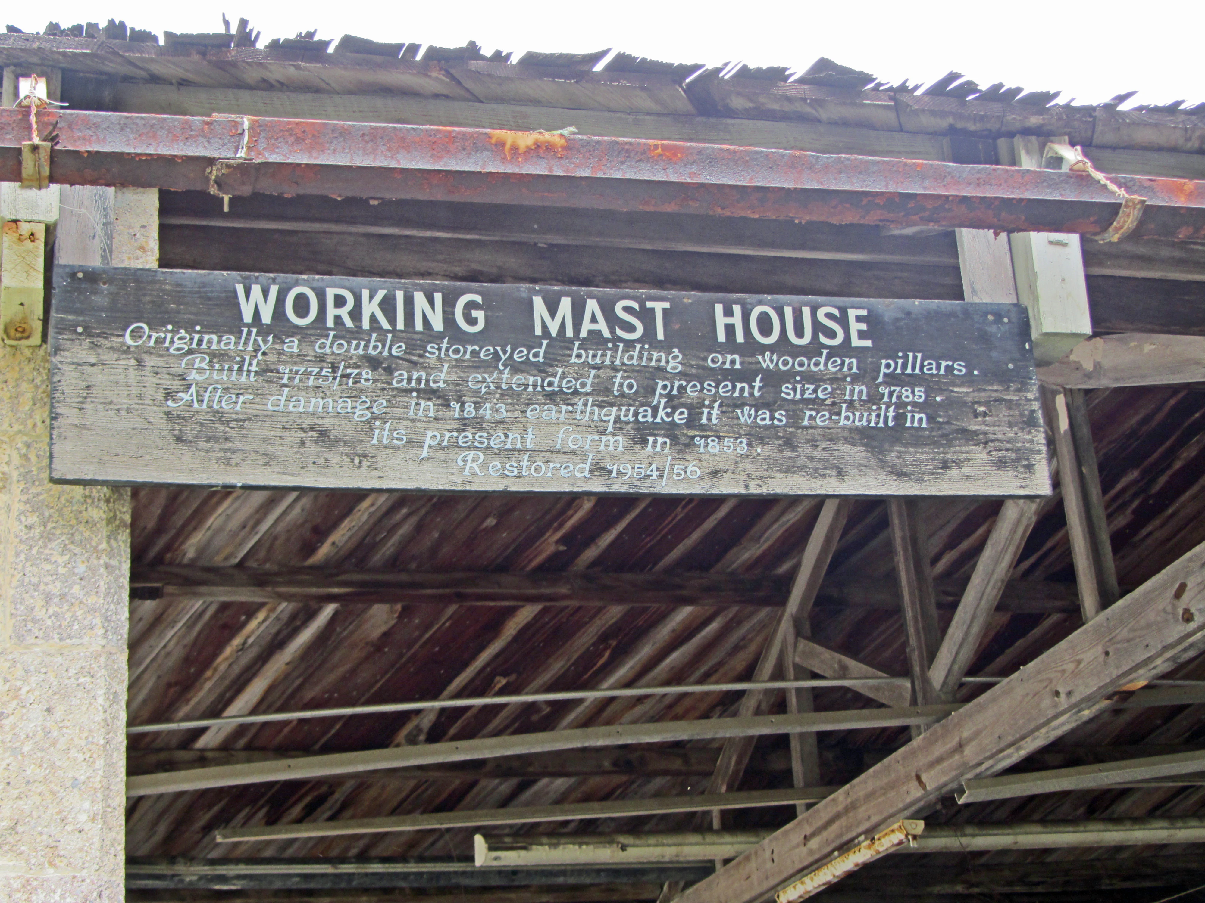
A wooden informational sign mounted on a historic structure reads Working Mast House, followed by historical text about the building's construction and restoration.
Informational signage at the Working Mast House in Nelson's Dockyard.

Best time to visit Nelson's Dockyard National Park

The character of a visit to Nelson's Dockyard National Park shifts with Antigua's tropical seasons. The cooler, drier months from roughly December through April are widely considered the most comfortable time, with calmer seas, clearer skies, and reliable harbour views from the cliff-top trails. This period also coincides with the peak of the international sailing calendar, including Antigua Sailing Week in late April and early May.

The warmer, wetter months from late spring through autumn bring higher humidity, a greater chance of heavy rain and tropical weather systems, and lusher vegetation on the surrounding hills. Hurricane season runs through this period, and the harbour's sheltered nature, so important in the site's military history, becomes especially relevant. Visits in this season are quieter, the marina is less crowded, and the dry-forest ridges around the dockyard show a different, greener seasonal character.

Monthly climate preview

Long-term monthly temperature and precipitation rhythm for Nelson's Dockyard National Park

Nelson's Dockyard National Park Climate Normals and Temperature Patterns

Representative coordinate records show average monthly temperatures ranging from 25.5 degrees Celsius to 28.25 degrees Celsius alongside varying daily precipitation rates throughout the year. Reviewing the complete twelve-month profile provides detailed climate data and long-term averages for Nelson's Dockyard National Park.
Annual mean27 °C
26 °C28 °C
Jan26°
Feb26°
Mar26°
Apr26°
May27°
Jun28°
Jul28°
Aug28°
Sep28°
Oct28°
Nov27°
Dec27°
Warmest month
September

28.3 °C

Coolest month
February

25.5 °C

Wettest month
October

5.1 mm/day

Driest month
March

1.1 mm/day

Park location guide

Geography guide, regional context, and park location map for Nelson's Dockyard National Park

Nelson's Dockyard National Park park geography, regions, and map view in Antigua and Barbuda

Understand where Nelson's Dockyard National Park sits in Antigua and Barbuda through a broader geographic reading of the surrounding landscape, nearby location context, and its mapped position within the national park landscape.

How Nelson's Dockyard National Park fits into Antigua and Barbuda

Antigua and Barbuda is a small island nation in the Caribbean Lesser Antilles, consisting of two main inhabited islands (Antigua and Barbuda) and several smaller islands. The country gained independence in 1981 and operates as a constitutional monarchy within the Commonwealth. It is known for its beaches, tourism economy, and strategic location between the Atlantic Ocean and Caribbean Sea.

Wider geography shaping Nelson's Dockyard National Park in Antigua and Barbuda

Antigua and Barbuda is located in the Caribbean Sea within the Leeward Islands of the Lesser Antilles. The country is bounded by the Atlantic Ocean to the east and the Caribbean Sea to the west. Antigua is mostly flat with the Shekerley Mountains in the southeast, while Barbuda is relatively flat with the Barbuda Highlands in the northwest. The Central Plain stretches from St. John's to English Harbour on Antigua. The country shares maritime borders with Anguilla, Saint Barthélemy, Saint Kitts and Nevis, Montserrat, and Guadeloupe.

Map view of Nelson's Dockyard National Park

Use this park location map to pinpoint Nelson's Dockyard National Park in Antigua and Barbuda, understand its exact geographic position, and read its mapped placement within the surrounding landscape more clearly.

Pigeon | © OpenStreetMap contributors

Location context for Nelson's Dockyard National Park

Antigua

Visualizing the terrain, Georgian architecture, and coastal scenery of English Harbour

Nelson's Dockyard National Park Photos and Protected Landscape Imagery

Visual documentation reveals the unique topography and historic character defining Nelson's Dockyard National Park across Antigua. Exploring these protected area photographs provides deep insight into the coastal vegetation, rugged headlands, and maritime infrastructure shaping the local environment.

A sunny view of English Harbour with a large sailing yacht docked, palm trees, and historic stone architecture in the foreground.

A white and black historic mechanical capstan stands in the foreground, with a large sailing vessel docked in the background at English Harbour.

A row of stone pillars stands along a harbor wall at Nelson's Dockyard, with blue water and green hills visible in the background.

A row of several tall, weathered stone columns with rounded caps standing in a grassy area at Nelson's Dockyard in Antigua, with palm trees and sailboats visible in the background.

Exterior view of a three-story brick historic building with white window shutters and potted plants on a stone patio.

A two-story white historic building with a wrap-around balcony, identified as the Dockyard Museum, with a cannon displayed in the foreground garden.

A high-angle view of a historic maritime facility with colonial-style buildings along a harbor waterfront, surrounded by lush green hills and anchored yachts.

A wooden informational sign mounted on a historic structure reads Working Mast House, followed by historical text about the building's construction and restoration.

A wide angle view from a stone-walled vantage point looking down at a harbor filled with yachts and sailboats, surrounded by lush green hills.

A wide view of the grassy area at Nelson's Dockyard, featuring low stone walls, white painted mooring bollards, and 18th-century stone buildings in the background.

A painted wooden figurehead of a woman in a long teal dress stands on display in a museum room, with an information sign in front of her.

A close up vertical shot of a wooden ship figurehead depicting a female torso with arms raised, mounted on a wall against a plain white background.

A large, black, antique metal ship anchor displayed on a low, raised stone platform in an outdoor courtyard.

Park atlas

Compare coastal landscapes and regional heritage sites across the wider island setting.

Explore Other Parks Near Nelson's Dockyard National Park and Surrounding Protected Areas

Continue your geographic exploration by browsing other protected areas and nearby national parks connected to the surrounding region. Comparing adjacent coastal terrains provides deeper context for maritime heritage sites and tropical conservation zones.
National parkAntigua and Barbuda
About 12 km away#1 closest

Northwest

Green Castle Hill National Park: Volcanic Landscapes and Archaeological Sites in Antigua

A preserved hilltop ridge within the Shekerley Mountains of Antigua.

Green Castle Hill preserves a significant volcanic landscape in the southwest of Antigua. Renowned for its circle of ancient standing stones and its status as the first national park within the Shekerley range, the site offers a unique intersection of cultural heritage and mountain geography. Access map-driven insights into the protected boundaries and regional terrain that define this Caribbean hilltop.

Established
2008
Relief
Mountain
Climate
Tropical
Scope
Terrestrial
Protected areaAntigua and Barbuda
About 19 km away#2 closest

Northwest

Fort Barrington Protected Area: Historic Coastal Ruins and Mapping in Antigua and Barbuda

Coastal hilltop ruins and strategic Caribbean maritime defense geography

Fort Barrington occupies a commanding vantage point above St. John's Harbour in Antigua and Barbuda. The site preserves stone ruins from an 18th century battery, illustrating the strategic importance of this elevated coastal landscape. Our data mapping highlights the fort's relationship to the harbor entrance, providing clear context for its role in colonial maritime defense and its ongoing environmental exposure within the Lesser Antilles.

Established
1779
Relief
Upland
Access
Easy access
Scope
Terrestrial
Marine protected areaFrance
About 32 km away#3 closest

Southeast

Sanctuaire Agoa: Exploring the Marine Protected Landscapes of the French Antilles

Regional marine mammal sanctuary and Caribbean oceanic geography

Sanctuaire Agoa represents a significant marine protected area spanning 143,000 square kilometers across the Caribbean. The sanctuary provides vital protection for humpback whales, dolphins, and various marine mammals while serving as a hub for regional cooperation in the Lesser Antilles. Mapping the sanctuary reveals a complex maritime space that stretches from shallow reef-fringed volcanic islands to deep ocean pelagic waters.

Area
143,256 km²
Established
2010
Climate
Tropical
Access
Access unknown
Watercolor painting of mountains, a lake, and green hills
National parkGuadeloupe
About 69 km away#4 closest

South

Guadeloupe National Park: Volcanic Rainforest and Protected Landscape Identity

Explore mapped boundaries and regional geography.

Guadeloupe National Park stands as a significant protected landscape, primarily defined by the dramatic volcanic terrain of Basse-Terre. This atlas entry focuses on the park's vital role in preserving one of the Caribbean's most extensive tropical rainforest ecosystems, centered around the active La Soufrière volcano. Understand its mapped boundaries, unique geographic setting within the Lesser Antilles, and its importance as a national park and UNESCO biosphere reserve.

Area
173 km²
Established
1989
IUCN
II
Relief
Mountain
Marine protected areaSint Eustatius
About 135 km away#5 closest

Northwest

Sint Eustatius National Marine Park: Protected Marine Geography and Atlas

Volcanic foundations, shipwreck reefs, and marine conservation zones

Sint Eustatius National Marine Park protects a diverse Caribbean marine ecosystem defined by its volcanic origins. The area features reefs growing on submerged lava flows and colonial shipwrecks, integrated with designated no-take reserves that safeguard critical sea turtle nesting sites and migratory corridors for cetaceans.

Area
27.5 km²
Established
1996
Climate
Tropical
Access
Access unknown
National parkDominica
About 161 km away#6 closest

South

Cabrits National Park: Protected Landscape and Geographic Context in Dominica

Explore Dominica's volcanic terrain and mapped protected areas.

Delve into the protected landscape of Cabrits National Park, a key component of Dominica's natural heritage. This entry provides an atlas-focused view of the park, detailing its geographic setting and mapped boundaries within the island nation. Understand how Cabrits National Park contributes to the regional geography of the Lesser Antilles and appreciate its significance as a protected natural area for structured discovery.

Area
5.3 km²
Established
1986
IUCN
II
Relief
Upland
National parkDominica
About 171 km away#7 closest

South

Morne Diablotin National Park: Dominica National Park Geographic Atlas Exploration

Mapped protected areas and regional landscape context.

Morne Diablotin National Park serves as a vital national park within Dominica, offering specific insights into its protected terrain and geographic setting. Explore its mapped boundaries and understand its role as a distinct natural landscape within the island's atlas, providing focused discovery for those interested in protected areas and their regional context.

Area
33.35 km²
Established
2000
Relief
Mountain
Climate
Tropical
Marine protected areaSint Maarten
About 177 km away#8 closest

Northwest

Man of War Shoal National Marine Park: Mapping the Protected Waters of Sint Maarten

A vital marine protected area on the edge of the Anguilla Bank.

Man of War Shoal National Marine Park represents a significant Caribbean marine sanctuary covering 3,100 hectares of coastal sea. The area is defined by its intact patch reefs, submerged 19th-century shipwrecks, and varied seabed topography, including vertical walls and expansive seagrass fields that support diverse pelagic and reef-dwelling marine life.

Area
31 km²
Established
2010
Relief
Lowland
Access
Easy access

Common questions about visiting, size, designation, and location context for Nelson's Dockyard National Park

Nelson's Dockyard National Park FAQs for park facts, access, geography, and protected area context

Find quick answers about Nelson's Dockyard National Park, including protected-area facts, park geography, trail and visitor context, and how the park fits into its surrounding country and regional landscape.
MoriAtlas Explorer

Continue Your Protected Areas Search Across the Global Atlas

Deepen your exploration by continuing the structured search for national parks and protected areas worldwide. Utilize the comprehensive filtering capabilities to compare different conservation landscapes and refine your understanding of global park geography. Discover more about the distribution and characteristics of protected natural areas.

Global natural geography