

Mori Atlas logo
Nature reserveNgambaa Nature Reserve

Explore the geographic intersection of remnant rainforests and diverse ironbark woodland ecosystems

Ngambaa Nature Reserve: Mapping the Protected Landscapes of the New South Wales Mid North Coast

Ngambaa Nature Reserve represents a key protected area within the New South Wales coastal hinterland, spanning over 10,000 hectares of ridges, valleys, and gullies. This detail page outlines the reserve's unique botanical composition, including its characteristic red cedar stands and rare ironbark diversity. Through our mapped atlas data, users can understand the ecological significance of this landscape and its connection to both ancient Aboriginal heritage and regional timber history.

nature reserveMid North CoastNew South Walescoastal hinterlandremnant rainforestred cedar

Ngambaa Nature Reserve

Nature reserve

Park overview

Structured park overview, official facts, and landscape profile for Ngambaa Nature Reserve

Ngambaa Nature Reserve park facts, protected area profile, and essential visitor context

Review the core facts for Ngambaa Nature Reserve, including designation, size, terrain, visitor scale, habitats, and operating context in one park-focused overview.

About Ngambaa Nature Reserve

Ngambaa Nature Reserve sits within the coastal hinterland of New South Wales, between the mountains and the Pacific Ocean, in a region characterised by a transition between subtropical rainforest, eucalyptus-dominated woodland, and cleared agricultural land. The reserve forms part of the broader Mid North Coast conservation estate assembled by the NSW National Parks and Wildlife Service, and its 10,560 hectares encompass a network of forest types that once extended far more widely across this part of eastern Australia.

A core element of Ngambaa's identity is its botanical diversity. Remnant rainforest provides habitat for red cedar and a suite of associated epiphytes, giving parts of the reserve a humid, sheltered character unusual for a coastal reserve of this scale. Beyond the rainforest pockets, the wider landscape supports ironbark woodland of notable conservation interest, with four species of ironbark recorded within the reserve, a level of ironbark diversity that signals the area's importance for this group of eucalypts.

The reserve also stands out for the presence of evolutionarily significant plant species. The small bolwarra, regarded as one of the most primitive flowering plants still surviving in the wild, is found within the reserve and gives the area particular biographic value for researchers and naturalists interested in ancient plant lineages. This combination of remnant rainforest, ironbark diversity, and primitive flora places Ngambaa among the botanically richer small reserves on the New South Wales coast.

Quick facts and research context for Ngambaa Nature Reserve

Ngambaa Nature Reserve is a 10,560-hectare protected area on the Mid North Coast of New South Wales, Australia, close to the town of Macksville. Managed by the NSW National Parks and Wildlife Service, it was formally gazetted on 1 January 1999 and classified under IUCN Category II as a national park-equivalent reserve. The reserve is notable for conserving rare flora, including rainforest patches, four ironbark species, and the primitive flowering plant small bolwarra.

Protection and recognition

Examine the documented terrestrial protection scope and administrative recognition history.

Ngambaa Nature Reserve Protection Status and Territorial Designation Facts

Ngambaa Nature Reserve maintains a documented terrestrial protection scope without external international recognition sources or transboundary status. Structured administrative records outline the baseline conservation framework governing the protected landscape.

Protection details

Protection scope
Terrestrial
Transboundary protection
No
Park context

Deeper park guide and search-rich context for Ngambaa Nature Reserve

Ngambaa Nature Reserve history, landscape, wildlife, and travel context

Explore Ngambaa Nature Reserve through its history, landscape character, ecosystems, wildlife, conservation priorities, cultural context, and seasonal travel timing in a structured park guide built for atlas discovery and search intent.

Why Ngambaa Nature Reserve stands out

Ngambaa Nature Reserve is best known for protecting a mosaic of rainforest remnants, ironbark woodland, and habitat for rare and threatened species along the New South Wales Mid North Coast. The reserve's combination of red cedar and associated epiphytes, primitive flowering plants such as the small bolwarra, and fauna like the powerful owl gives it a distinctive botanical and ecological character despite its relatively small size. It is also recognised for the way its landscapes connect natural values with cultural heritage, including sites of significance to local Aboriginal communities and traces of historical non-Aboriginal land use in the surrounding timber country.
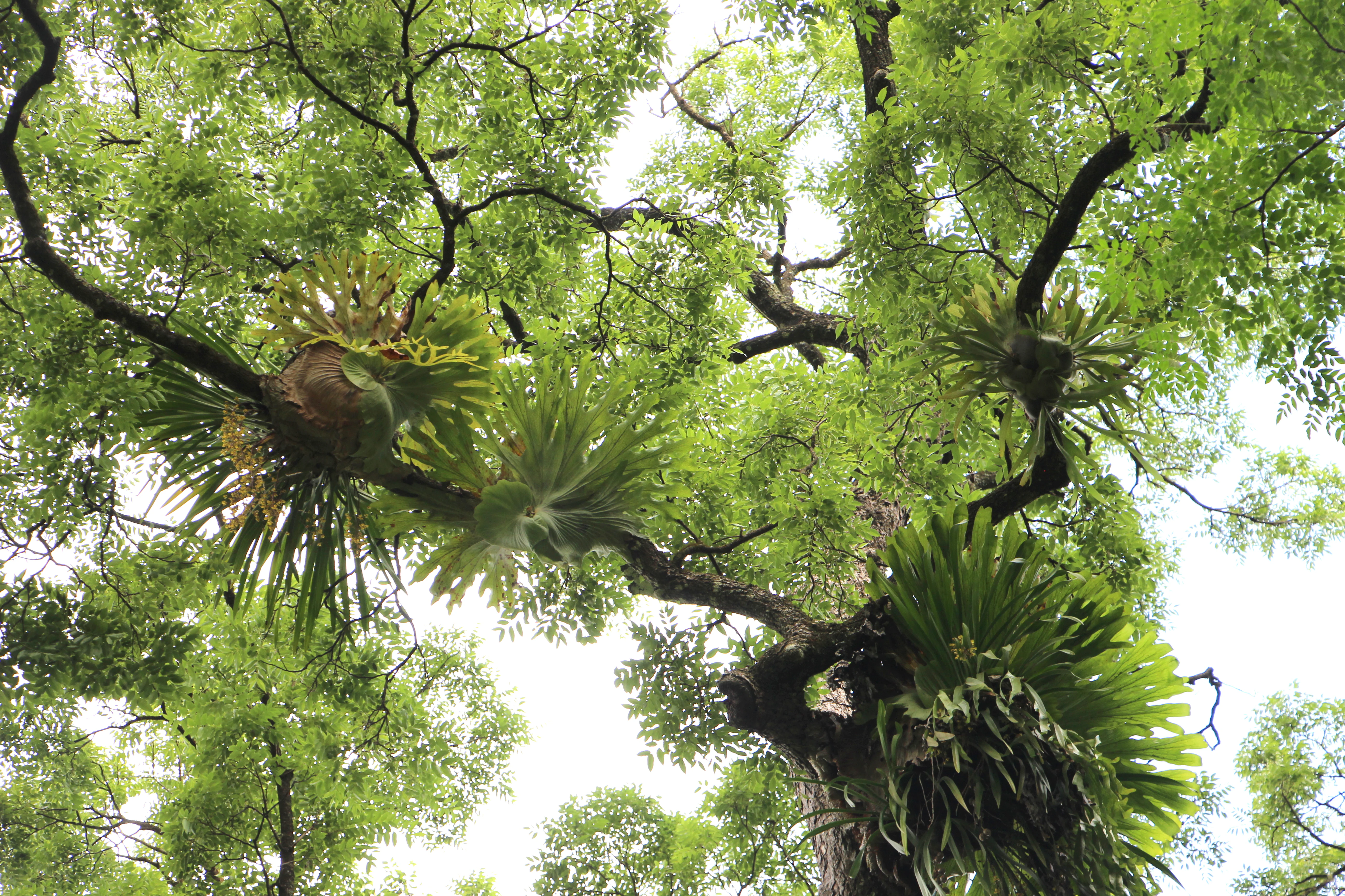
A low angle view looking up into the canopy of a tall tree, showing several large staghorn or elkhorn ferns growing as epiphytes on the tree branches.
Epiphytic ferns growing on a tree canopy within the Ngambaa Nature Reserve.

Ngambaa Nature Reserve history and protected-area timeline

The landscape of Ngambaa Nature Reserve has long been part of the territory of local Aboriginal communities, whose connection to the land continues to shape its cultural significance. The reserve contains sites and landscapes of enduring value to these communities, reflecting patterns of use, occupation, and customary association that predate European settlement.

In more recent centuries the area fell within the timber-getting frontier that swept through the coastal forests of New South Wales, and the region was worked for high-value cabinet timbers including red cedar. The remnants of that era are visible in the composition of the surviving forests and in the cultural memory of the landscape.

Ngambaa Nature Reserve was formally gazetted as a protected area on 1 January 1999 under the administration of the NSW National Parks and Wildlife Service, bringing this mosaic of forest, rainforest, and cultural landscape into the formal New South Wales conservation estate.

Ngambaa Nature Reserve landscape and geographic character

The reserve lies in a transitional coastal-hinterland setting, where the eastern escarpment country of New South Wales gives way to lower hills, ridges, and valleys before reaching the Pacific coastal plain. Elevations within the reserve are relatively low, sitting broadly around 139 metres above sea level, which contributes to a landscape that combines gentle ridgelines, sheltered gullies, and small creek lines.

A defining visual feature of Ngambaa is the contrast between its moist, closed-canopy rainforest remnants, often dominated by red cedar and festooned with epiphytes, and the more open ironbark woodland that occupies the drier slopes and ridges. The rainforest pockets have an almost subtropical appearance, with hanging vines and epiphytic plants contributing to a layered, sheltered feel, while adjoining ironbark communities are more typically Australian in their open, sunlight-dappled character.

Together, these landform and vegetation patterns give the reserve a varied topography for its size, with shifting light, canopy density, and understorey character as one moves between gullies and ridges.

Ngambaa Nature Reserve ecosystems, habitats, and plant life

Ecologically, Ngambaa is defined by the juxtaposition of remnant subtropical rainforest with extensive ironbark woodland, a combination that supports a wide range of plant and animal life. The rainforest fragments are particularly important for moisture-dependent species, while the ironbark communities support different suites of birds, insects, and other fauna adapted to drier, more open conditions.

Vegetation diversity is a hallmark of the reserve. The presence of four ironbark species within a relatively small area points to a relatively complex underlying geology and soils, allowing different ironbark taxa to coexist across microhabitats. Rainforest species such as red cedar are accompanied by a community of epiphytes that depend on the humid, sheltered conditions these forests provide.

The reserve's ecological character is reinforced by the presence of evolutionarily distinctive plants such as the small bolwarra, whose persistence in the area is a reminder of the ancient floral lineages that still survive in protected pockets along the New South Wales coast.

Ngambaa Nature Reserve wildlife and species highlights

Wildlife at Ngambaa reflects the reserve's mix of rainforest and open woodland, with fauna ranging from species tied to moist forest interiors to those that prefer drier ironbark habitats. One of the reserve's signature animal inhabitants is the powerful owl, the largest owl in Australia, which requires large hunting territories; a single pair can range over roughly 1,000 hectares, making sightings relatively uncommon.

The powerful owl's diet in the reserve centres on arboreal mammals such as possums and sugar gliders, both of which depend on the older trees and hollow-bearing vegetation that the reserve's mature woodland and rainforest patches provide. The persistence of these prey species is itself an indicator of the structural complexity of the forest.

Beyond the powerful owl, the reserve's habitat mosaic is likely to support a broader suite of forest-dependent birds, mammals, and reptiles typical of the Mid North Coast, although the published information specifically highlights the owl and its prey species as key elements of the reserve's wildlife identity.

Ngambaa Nature Reserve conservation status and protection priorities

Ngambaa Nature Reserve plays a focused role in the conservation of rare and threatened flora and fauna in the Mid North Coast region. By protecting rainforest remnants and a notable diversity of ironbark species within a single landscape, the reserve helps safeguard plant communities that have been heavily reduced elsewhere through clearing for agriculture and historical timber harvesting.

The reserve is also significant for the protection of evolutionary relicts such as the small bolwarra, one of the most primitive flowering plants still in existence. Conserving populations of such species adds to the biological importance of the New South Wales protected-area estate and provides reference sites for researchers studying ancient plant lineages.

Classified under IUCN Category II and managed by the NSW National Parks and Wildlife Service, Ngambaa contributes to a broader network of coastal and hinterland reserves that together maintain habitat connectivity and refuge areas for species sensitive to disturbance in surrounding lands.

Ngambaa Nature Reserve cultural meaning and human context

The landscapes of Ngambaa Nature Reserve hold ongoing significance for local Aboriginal communities, whose connection to the land long predates the formal gazettal of the reserve. The reserve's forests, ridges, and creeks form part of a cultural landscape shaped by generations of Aboriginal presence, use, and stewardship.

The non-Aboriginal cultural history of the reserve is largely tied to the timber-getting era of the New South Wales coast, when red cedar and other cabinet timbers drew workers into these hinterland forests. The continuing importance of red cedar within the reserve echoes this layered human history, with the tree being both an ecological standout and a cultural marker of past industry.

Together, these Aboriginal and post-contact legacies give Ngambaa a cultural depth beyond its formal conservation role, making it a place where natural values and human history are closely intertwined.

Top sights and standout views in Ngambaa Nature Reserve

Among Ngambaa Nature Reserve's standout features is the contrast between sheltered rainforest remnants, dominated by red cedar and a rich epiphyte layer, and the surrounding ironbark woodland, which is unusually diverse for a reserve of this size. The presence of four ironbark species within the same landscape is a particular point of ecological distinction.

Equally notable is the survival of the small bolwarra, a primitive flowering plant that anchors the reserve's significance for evolutionary botany, and the presence of the powerful owl, whose large territorial requirements make any reserve supporting the species ecologically meaningful. These elements, combined with the reserve's Aboriginal cultural landscape and its post-contact timber heritage, give Ngambaa a layered identity that goes well beyond its modest overall area.

Best time to visit Ngambaa Nature Reserve

As a low-elevation coastal-hinterland reserve in New South Wales, Ngambaa benefits from a temperate climate with relatively mild winters and warm, sometimes humid summers. The cooler months of late autumn, winter, and early spring generally offer more comfortable walking conditions, lower temperatures, and reduced insect activity, while also highlighting the structural contrast between rainforest and open woodland without the heavy summer understorey growth.

Spring is often rewarding for observing flowering and活跃性 in the understorey, while bird activity, including for species such as the powerful owl and its prey base, can be influenced by seasonal patterns. Visitors interested in a quieter experience and sharper views through the forest may find the drier months most appealing. As with any reserve, conditions and access may vary, so planning visits around local weather is advisable.

Monthly climate preview

Long-term temperature and precipitation records across twelve measured months

Ngambaa Nature Reserve Climate Normals and Annual Weather Patterns

Representative coordinates record distinct annual temperature ranges and monthly precipitation levels across the reserve terrain. Examining full climatological averages helps track long-term environmental patterns for this protected location.
Annual mean17 °C
10 °C22 °C
Jan22°
Feb21°
Mar20°
Apr17°
May14°
Jun11°
Jul10°
Aug12°
Sep15°
Oct18°
Nov19°
Dec21°
Warmest month
January

22.3 °C

Coolest month
July

10.5 °C

Wettest month
February

6.1 mm/day

Driest month
July

1.4 mm/day

Park location guide

Geography guide, regional context, and park location map for Ngambaa Nature Reserve

Ngambaa Nature Reserve park geography, regions, and map view in Australia

Understand where Ngambaa Nature Reserve sits in Australia through a broader geographic reading of the surrounding landscape, nearby location context, and its mapped position within the national park landscape.

How Ngambaa Nature Reserve fits into Australia

Australia is a constitutional monarchy and federal parliamentary democracy comprising six states and ten territories. With a population of nearly 28 million, it is one of the world's most urbanised countries, with most people concentrated on the eastern seaboard. The country has a high Human Development Index and is known for its cultural diversity, ancient Aboriginal heritage, and unique wildlife.

Wider geography shaping Ngambaa Nature Reserve in Australia

Australia occupies the entire Australian continent, the island of Tasmania, and numerous smaller islands. It is the world's flattest and driest inhabited continent, featuring vast deserts in the interior (the Outback), tropical rainforests along the eastern coast, and a coastline bordering the Indian and Pacific Oceans.

Map view of Ngambaa Nature Reserve

Use this park location map to pinpoint Ngambaa Nature Reserve in Australia, understand its exact geographic position, and read its mapped placement within the surrounding landscape more clearly.

Pigeon | © OpenStreetMap contributors

Location context for Ngambaa Nature Reserve

New South Wales

Explore visual records of remnant rainforests, ironbark woodlands, and protected terrain variations.

Ngambaa Nature Reserve Photos and Landscape Scenery: Visualizing Protected Coastal Hinterland Habitats

Visual documentation reveals the distinct topography and habitat contrast defining Ngambaa Nature Reserve across its coastal hinterland setting. Detailed imagery provides clear spatial context for rare flora, rainforest canopies, and protected terrain features.

A low angle view looking up into the canopy of a tall tree, showing several large staghorn or elkhorn ferns growing as epiphytes on the tree branches.

Park atlas

Compare regional coastal hinterland landscapes and connected conservation reserves

Explore Protected Areas and Other Parks Near Ngambaa Nature Reserve

Browse other parks near Ngambaa Nature Reserve to examine similar coastal hinterland terrain, remnant rainforest stands, and ironbark woodland communities across the surrounding region. Extending the geographic comparison reveals broader protected-area patterns and connects isolated habitat fragments to wider New South Wales conservation landscapes.
National parkNew South Wales
About 19 km away#1 closest

Northeast

Yarriabini National Park: National Park Protected Landscape Discovery in New South Wales

Explore mapped boundaries and regional geographic context.

Yarriabini National Park is a key protected area situated within the geographic expanse of New South Wales, Australia. This national park offers a clear case for understanding distinct landscape units and their mapped coverage. Within MoriAtlas, this profile facilitates a structured exploration of the park's protected status, its relationship to the surrounding terrain, and its contribution to the broader atlas of Australian conservation landscapes.

Area
20.92 km²
Established
2003
IUCN
II
Relief
Upland
National parkNew South Wales
About 19 km away#2 closest

Northwest

New England National Park: Escarpment Landscape and Protected Area Discovery in New South Wales

Explore dramatic cliffs, ancient rainforests, and diverse ecosystems.

New England National Park represents a critical protected landscape on the eastern edge of New South Wales' Northern Tablelands. This area is characterized by its spectacular escarpment country, featuring impressive cliffs, rugged ridges, and deep valleys that cradle some of Australia's most botanically rich environments. As a designated national park, it preserves ancient ecosystems and offers unique opportunities for atlas-based geographic discovery of its mapped terrain and wilderness character.

Area
673 km²
Established
1937
IUCN
Ib
Relief
Mountain
National parkNew South Wales
About 22 km away#3 closest

Northwest

Dunggir National Park: Protected Subtropical Rainforest and Biodiversity Hub in New South Wales

Mapped national park landscape and Gumbaynggirr cultural context.

Dunggir National Park offers a detailed view into Australia's protected natural areas, specifically highlighting the unique subtropical rainforest environments of New South Wales. With a focus on conservation, this national park preserves a dense mosaic of three distinct rainforest types and is a sanctuary for significant biodiversity, including multiple endangered species. Its geographic placement and designation as a national park make it a key location for understanding regional ecosystems and the indigenous Gumbaynggirr heritage, with the park's name honouring the culturally significant koala.

Area
25 km²
Established
1997
IUCN
II
Relief
Upland
National parkNew South Wales
About 25 km away#4 closest

Southeast

Hat Head National Park: Protected Landscape and Geographic Context in New South Wales

Explore mapped boundaries and regional park geography.

Hat Head National Park serves as a key protected area within New South Wales, Australia, offering rich opportunities for geographic discovery. This entry provides detailed insights into its mapped park boundaries and the surrounding natural landscape, positioning it within a broader atlas framework for understanding its regional significance and protected-area status. Explore the core geographic identity of this important national park.

Area
74 km²
Established
1972
IUCN
Ib
Relief
Mixed relief
State or regional parkNew South Wales
About 26 km away#5 closest

Northwest

Gumbaynggirr State Conservation Area: Protected Forest Geography and Map

Subtropical rainforest conservation on the New South Wales Mid North Coast

Gumbaynggirr State Conservation Area protects a compact yet significant expanse of unlogged subtropical rainforest near Nambucca Heads. The reserve encompasses a fertile basalt plateau at 750 metres elevation, where high moisture levels support a towering canopy of yellow carabeen and Moreton Bay fig. This atlas resource provides a structured look at the park boundaries, volcanic substrate, and the ecological heritage of the League Scrub and Little Wonder forest sections.

Area
25.61 km²
Established
2003
Relief
Upland
Climate
Subtropical
National parkNew South Wales
About 27 km away#6 closest

East

Arakoon National Park: Explore New South Wales' Coastal Protected Landscape and Heritage

Mapped boundaries and natural terrain of a key Australian national park.

Arakoon National Park represents a vital protected area in New South Wales, Australia, characterized by its dramatic coastal geography. This park offers an in-depth look at its mapped terrain, including headlands, beaches, and forests, providing essential context for understanding Australia's protected lands. Its importance extends to its dual identity as a significant Aboriginal cultural landscape and a site of colonial historical interest, making it a multifaceted destination for geographic and protected-area discovery.

Area
115 km²
Established
2013
IUCN
II
Relief
Lowland
National parkNew South Wales
About 28 km away#7 closest

Southwest

Kumbatine National Park: Protected Landscape and Geographic Context in New South Wales

Explore its mapped terrain and subtropical forest ecosystems.

Kumbatine National Park represents a vital tract of protected subtropical forest and eucalypt bushland within New South Wales' Northern Rivers region. This detail page provides an atlas perspective on the park's geography, featuring the prominent Mount Kippara and the watershed of Glencoe Creek. Understand its unique landscape context and its significance as a preserved natural area in a region marked by extensive land clearing, offering rich details for geographic exploration.

Area
130 km²
Established
1999
IUCN
II
Relief
Mixed relief
National parkNew South Wales
About 29 km away#8 closest

South

Maria National Park: National Park Within New South Wales' Geographic Atlas

Mapped boundaries and protected landscape context.

Maria National Park is cataloged as a national park, situated within the broader geographic atlas of New South Wales, Australia. This entry provides structured information focusing on its identity as a protected landscape, detailing its mapped boundaries and its place within the regional geography. Understand Maria National Park through its defined park status and the surrounding natural context for detailed exploration.

Area
23 km²
Established
1999
IUCN
II
Relief
Lowland

Common questions about visiting, size, designation, and location context for Ngambaa Nature Reserve

Ngambaa Nature Reserve FAQs for park facts, access, geography, and protected area context

Find quick answers about Ngambaa Nature Reserve, including protected-area facts, park geography, trail and visitor context, and how the park fits into its surrounding country and regional landscape.
MoriAtlas Explorer

Continue Your Protected Areas Search Across the Global Atlas

Deepen your exploration by continuing the structured search for national parks and protected areas worldwide. Utilize the comprehensive filtering capabilities to compare different conservation landscapes and refine your understanding of global park geography. Discover more about the distribution and characteristics of protected natural areas.

Global natural geography