
Streams
Park geography
A structured look at land area, mountainous terrain, and recorded natural features
Olympic National Forest Geography, Mapped Boundaries and Physical Terrain Profile
This geographic profile details the physical landscape of Olympic National Forest, spanning over 2541 square kilometers in Washington. The data encompasses mountain relief, diverse riverine environments, and specific landmarks such as Mount Muller and the Dosewallips River. Use this structured layout to visualize protected land boundaries, habitat types, and the surrounding natural terrain.

A vast temperate rainforest and rugged mountain landscape encircling Olympic National Park on Washington's Olympic Peninsula.
Olympic National Forest
Olympic National Forest is a U.S. National Forest located on the Olympic Peninsula in Washington state, covering roughly 628,000 acres that nearly surround Olympic National Park and the Olympic Mountains. Spanning parts of Clallam, Grays Harbor, Jefferson, and Mason counties, it protects a remarkable range of Pacific Northwest landscapes, from coastal temperate rainforests fed by extremely high rainfall to the saltwater fjord of Hood Canal, and from glacier-fed rivers to the rugged peaks surrounding Mount Washington. The forest is administered by the U.S. Forest Service in two ranger districts, the Pacific Ranger District on the wetter western side and the Hood Canal Ranger District on the eastern side, with headquarters in Olympia. It contains several designated wilderness areas, large lakes, and extensive tracts of old-growth forest that together form one of the most ecologically distinctive national forests in the contiguous United States. Beyond its ecological significance, the forest is central to ongoing debates about land management on the peninsula, particularly through the Wild Olympics campaign, which has sought to expand wilderness and Wild and Scenic River protections across large portions of its acreage.
- Location
- United States of America
- Park type
- Protected landscape
- Established
- 1897
- Area
- 2,541.9 km²
Location overview
Regional administrative placement and coastal geographic profile settings
Olympic National Forest Geographic Overview and Location Status in Washington
Olympic National Forest is situated within the United States of America across the state of Washington. Protected area records confirm the coastal designation while omitting marine or island attributes.
- Countries
- United States of America
- Regions
- Washington
- Primary location
- Washington
- Geographic setting
- Coastal
Boundary and coordinates
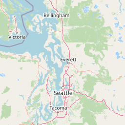
Olympic National Forest’s outline covers 2,541.89 km²
Olympic National Forest mapped boundary and 2,541.89 km² area
Olympic National Forest has geometry covering its recorded 2,541.89 km² extent. The mapped form supplies geographic context for the forest without claiming cadastral precision or legal authority.
- Boundary area
- 2,559.4 km²
- Boundary perimeter
- 1,194.5 km
- Northernmost point
- 48.1654° N
- Southernmost point
- 47.2992° N
- Easternmost point
- 122.881° W
- Westernmost point
- 124.3526° W
- Geographic centre
- 47.6832° N, 123.5424° W
- North–south span
- 96.3 km
- East–west span
- 110.4 km
Terrain and natural features
Stored mountain classifications and recorded geographic features
Olympic National Forest Terrain and Named Natural Features
Olympic National Forest maintains a mountain terrain classification featuring various recorded peaks, rivers, and lakes. Linked feature cards provide names, types, measurements, and spatial relationships where recorded.
Selected named natural features
Peaks
Green Hill
725 m
Streams
Chikamin Creek
Peaks
Gibson Peak
1,336 m
Streams
Fulton Creek
Peaks
Buckhorn Mountain
2,129.9 m
Environmental setting
Temperate mountain relief, major water bodies, and forest cover profiles
Olympic National Forest Environmental Classifications and Physical Settings
Recorded landscape features and habitat types serve as interpretive categories for the physical setting of Olympic National Forest. Linked classifications connect recorded environmental properties to related atlas destinations across the region.
- Relief
- Mountain
- Climate
- Temperate
- Water
- Major water bodies
- Forest cover
- Mostly forested
- Seasonality
- Year-round
Landscape features
Mountains · Forest · Coast · Lakes · Rivers
Habitat types
Temperate coniferous forest · Tropical forest · Riverine habitat
Park atlas
Compare regional park geography and adjacent Pacific Northwest wilderness areas.
Parks Near Olympic National Forest and Surrounding Protected Landscapes
Browse other national parks and protected areas sharing the rugged mountainous terrain and temperate rainforest geography of the Olympic Peninsula. Regional comparison reveals broader ecological patterns across adjacent river valleys, alpine ridges, and coastal reserves.
Wildlife reserveWashington
Park boundaries overlap#1 closest
Southwest

Mount Skokomish Wilderness: Ridge Systems and Alpine Geography in Washington State
Exploration of a protected Olympic Peninsula mountain landscape.
Mount Skokomish Wilderness protects a dramatic stretch of the eastern Olympic Mountains defined by steep ridges and glacial basins. The area serves as a critical headwaters region and offers a dense display of peaks and old-growth forest transitions across its varied elevation profile, providing essential landscape context for the region.
- Area
- 53.79 km²
- Established
- 1984
- IUCN
- Ib
- Relief
- Mountain
National parkWashington
Park boundaries overlap#2 closest
Northwest
Olympic National Park National Park: Geographic Atlas and Protected Landscape Discovery
Explore its unique Washington landscape and mapped protected areas.
Olympic National Park serves as a key protected area within Washington, offering rich opportunities for geographic exploration. This detail page provides essential context on its designation as a national park, its mapped boundaries, and its contribution to the regional geography. Understand the park's specific landscape character and its role within the atlas of protected lands, facilitating a structured approach to discovering its natural terrain and geographic significance.
- Area
- 3,733.8 km²
- Established
- 1938
- IUCN
- II
- Visitors
- 3.7M annual
Marine protected areaWashington
11 km away#3 closest
West
Olympic Coast National Marine Sanctuary: Mapping the Washington Outer Coast Marine Protected Area
Pacific Ocean canyons, shelf ecosystems, and coastal wilderness
Defined by its proximity to the Olympic Peninsula, this marine protected area spans a rugged stretch of the Pacific Ocean. The sanctuary encompasses significant seafloor features including the Nitinat and Quinault canyons, alongside dynamic upwelling zones that support diverse marine life and complex tidal habitats.
- Area
- 8,260 km²
- Established
- 1994
- IUCN
- IV
- Climate
- Temperate
Nature reserveBritish Columbia
About 26 km away#4 closest
Northwest

Race Rocks Ecological Reserve: Protected Marine Landscape and Island Geography
Nature reserve in the Strait of Juan de Fuca, British Columbia
Race Rocks Ecological Reserve is a geographically distinct protected area consisting of low-lying rocky islets and surrounding high-current marine waters. Located in the Strait of Juan de Fuca, the reserve is recognized for its intense tidal mixing, which supports productive food webs and diverse marine mammals. This site provides a vital window into the ecological dynamics of the Pacific coast through its role as a dedicated research and conservation zone.
- Area
- 2.27 km²
- Established
- 1980
- IUCN
- Ia
- Relief
- Lowland
National parkBritish Columbia
43 km away#5 closest
Northwest
Pacific Rim National Park Reserve: National Park Protected Landscape & Map Atlas
Mapped boundaries and regional geographic context in British Columbia.
Pacific Rim National Park Reserve stands as a distinct protected natural landscape, serving as a critical component of Canada's national park inventory. This page facilitates an atlas-style exploration of its mapped boundaries and its position within the broader geography of British Columbia. Understanding the park's protected status and its integration with the surrounding natural terrain offers valuable insight into conservation landscapes.
- Area
- 511 km²
- Established
- 1970
- IUCN
- VI
- Visitors
- 1.2M annual
National parkBritish Columbia
58 km away#6 closest
North
Gulf Islands National Park Reserve: British Columbia National Park Protected Area
Mapped boundaries and regional geographic context.
Delve into the protected landscape of Gulf Islands National Park Reserve, a significant national park located in British Columbia. This entry provides detailed insights into its mapped boundaries, regional geographic setting, and its identity as a protected area. Understand the park's place within the natural terrain and atlas of Canada, offering a clear geographic overview for focused discovery and landscape context.
- Area
- 36 km²
- Established
- 2003
- IUCN
- VI
- Visitors
- 28.4K annual
Marine protected areaUnited States of America
About 66 km away#7 closest
Northeast
Padilla Bay National Estuarine Research Reserve: Coastal Protected Area Geography
A significant tidal estuary and marine protected landscape in Washington
This marine protected area encompasses large, shallow tidal mudflats and salt marshes within the Salish Sea. It serves as a essential hub for ecological research and conservation, framing a hybrid environment where historical diked farmlands meet protected coastal terrain. The reserve offers deep insight into the regional geography of Washington, detailing how tidal processes and human history have shaped this productive Pacific Northwest estuarine landscape.
- Area
- 32 km²
- Established
- 1980
- Relief
- Lowland
- Access
- Easy access

Protected landscapeWashington
80 km away#8 closest
East
Mount Baker, Snoqualmie National Forest: Mapped Geography and Protected Landscape Analysis
Exploratory atlas of Washington's primary Cascade Range wilderness
Delve into the structural geography of Mount Baker, Snoqualmie National Forest. This protected area corridor serves as a major ecological transition zone between the Puget Sound lowlands and the interior Cascades, characterized by extensive glaciers, wild river systems, and iconic stratovolcanoes that define the regional landscape of Washington state.
- Area
- 6,978 km²
- Established
- 1974
- Relief
- Mountain
- Climate
- Alpine
MoriAtlas Explorer
View the Olympic National Forest Geographic Map and Protected Landscape Atlas
Navigate the complex terrain of the Olympic Peninsula by examining the boundaries and diverse natural features of Olympic National Forest. This MoriAtlas entry provides a structured look at the old-growth forests, wilderness zones, and river systems that define one of the most ecologically significant national forests in the United States.
Browse next
Global natural geography
Explore related park routes
Explore MoriAtlas Global ParksBrowse All MoriAtlas ParksGlobal Park Map DiscoveryMoriAtlas: Browse All CountriesBrowse All MoriAtlas ContinentsNational Park Environment AtlasGrand Canyon National Park AtlasYellowstone National Park AtlasYosemite National Park Atlas and GeographySerengeti National Park AtlasGalápagos National Park Protected LandscapeBanff National Park Geography and AtlasKruger National Park Atlas EntryUluṟu-Kata Tjuṯa National Park AtlasExplore Uluru-Kata Tjuta National Park GeographyPlitvice Lakes National Park AtlasFiordland National Park Protected LandscapeGreat Smoky Mountains National Park AtlasAfghanistan National Parks and Protected AreasAlbania National Parks and Protected AreasAlgeria National Parks and Protected AreasAmerican Samoa National Parks and Protected AreasAndorra National Parks and Protected AreasAngola National Parks and Protected AreasAntarctica National Parks and Protected AreasAntigua and Barbuda Park List