Mori Atlas logo
National parkPaluma Range National Park

Discover the mapped protected landscape and regional geographic context of Paluma Range National Park.

Paluma Range National Park: A Queensland National Park for Geographic Discovery

Paluma Range National Park, located in Queensland, Australia, is a significant protected area offering a unique lens into the region's natural landscapes. As a national park, it serves as a critical component of the geographic atlas for northeastern Australia, showcasing distinct terrain and mapped boundaries. This page provides foundational context for understanding the park's protected status and its place within the broader geographical framework of Queensland.

National ParkRainforestWaterfallsImportant Bird AreaCassowary HabitatMountain Landscape
An illustration of a waterfall flowing through a forested valley with rocky cliffs, a stream, and dense vegetation under a partly cloudy sky

Paluma Range National Park

National park

Park overview

Structured park overview, official facts, and landscape profile for Paluma Range National Park

Paluma Range National Park park facts, protected area profile, and essential visitor context
Review the core facts for Paluma Range National Park, including designation, size, terrain, visitor scale, habitats, and operating context in one park-focused overview.

About Paluma Range National Park

Paluma Range National Park protects a substantial area of mountain rainforest and adjacent ecosystems in the Paluma Range of north Queensland. The park sits between the regional centers of Townsville and Ingham, accessible via the Paluma Range road that winds through the protected area. The park's geography is defined by rugged mountainous terrain with elevations that support moist microclimates and create the conditions for rainforest persistence in an otherwise predominantly dry tropical region. Several permanent watercourses traverse the park, feeding into the broader catchment that includes the notable waterfalls for which the area is named. Lake Paluma, formed by damming, provides additional aquatic habitat within the park boundaries. The park's protection extends across multiple habitat types including riparian corridors, open woodland, and the dominant subtropical rainforest that characterizes the higher elevations. This diversity of habitats supports an array of wildlife species, with the southern cassowary being the most ecologically significant. The park is part of a broader network of protected areas in north Queensland that collectively help preserve the region's exceptional biodiversity.

Quick facts and research context for Paluma Range National Park

Paluma Range National Park covers 172 square kilometers in north Queensland, Australia, approximately 1,188 kilometers north of Brisbane. The park was established in 1994 and received a significant 6,510-hectare expansion in 2010. It contains several notable water features including Jourama Falls, Birthday Creek Falls, Crystal Creek, and Lake Paluma. The park lies within the Paluma Important Bird Area, recognized by BirdLife International for its exceptional bird conservation significance. The park is managed by the Queensland Parks and Wildlife Service.

Park context

Deeper park guide and search-rich context for Paluma Range National Park

Paluma Range National Park history, landscape, wildlife, and travel context
Explore Paluma Range National Park through its history, landscape character, ecosystems, wildlife, conservation priorities, cultural context, and seasonal travel timing in a structured park guide built for atlas discovery and search intent.

Why Paluma Range National Park stands out

Paluma Range National Park is best known for protecting significant populations of the southern cassowary, a large and flightless bird species classified as vulnerable. The park lies within a formally designated Important Bird Area because it represents a southern outlier for many tropical bird species and contains a significant cassowary population. The park is also renowned for its string of spectacular waterfalls cascading from the Paluma Range, particularly Jourama Falls and Birthday Creek Falls, which are popular visitor destinations. The combination of mountain rainforest, waterfall scenery, and cassowary habitat makes this park a distinctive conservation area in the Australian wet tropics region.

Sunlight filtering through tall trees in a tropical rainforest with a small stream flowing over rocks
Tropical rainforest scene in Paluma Range National Park with a stream flowing through dense vegetation

Paluma Range National Park history and protected-area timeline

Paluma Range National Park was established in 1994 as a formal protected area under Queensland state legislation. The park was created to preserve the significant natural values of the Paluma Range, including its unique rainforest ecosystems and the endangered southern cassowary populations. On National Parks Day in March 2010, the Queensland State Government announced a significant expansion of the park, adding 6,510 hectares to the protected area. This expansion strengthened conservation protection for cassowary habitat and improved connectivity within the regional protected area network. The park is managed by the Queensland Parks and Wildlife Service, which conducts ongoing management activities including fire management, invasive species control, and visitor facilities maintenance. The park's establishment reflected growing recognition of the Paluma Range's ecological significance, particularly its role as a southern refuge for tropical species typical of far north Queensland and Papua New Guinea.

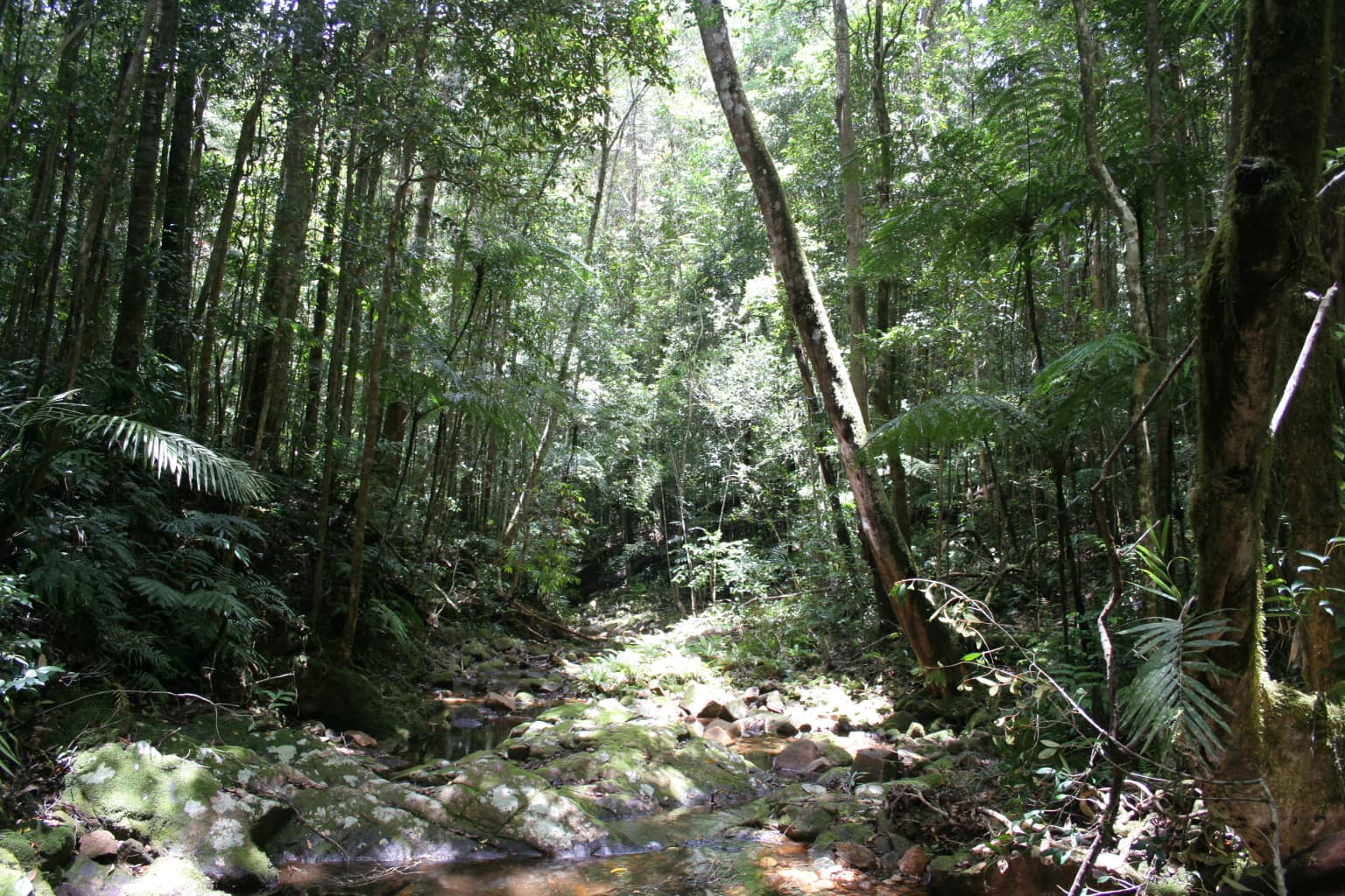
Paluma Range National Park landscape and geographic character

The Paluma Range presents a landscape of rugged mountain terrain rising from the surrounding coastal plains of north Queensland. The range creates a moist barrier that captures moisture from prevailing winds, supporting rainforest and wet forest ecosystems in an otherwise seasonally dry tropical environment. The park's streams and waterfalls represent some of its most scenic features, with Jourama Falls being a major waterfall where water cascades over rocky outcrops into natural pools below. Birthday Creek Falls offers another significant waterfall destination within the park. Crystal Creek provides additional aquatic scenery as it flows through the protected area. Lake Paluma, formed by the Paluma Dam, adds a reservoir element to the park's landscape, surrounded by forested hillslopes. The terrain varies from steep escarpments and ridges to more gentle valley floors where watercourses have carved their courses. Rocky outcrops and exposed granite surfaces are visible throughout the landscape, particularly near waterfall sites where water has shaped the underlying geology.

Paluma Range National Park ecosystems, habitats, and plant life

The Paluma Range National Park protects a remarkably biodiverse area representing the southernmost extent of many tropical species in Australia. Most of the park lies within the Paluma Important Bird Area, formally designated by BirdLife International because of its exceptional bird conservation values. The park's moist rainforest habitats support species more typical of far northern Queensland and tropical regions, making it a southern outpost for biodiversity. The subtropical rainforest that dominates higher elevations features tall trees, dense canopy, and the characteristic epiphytes and vines of wet tropical forests. Wet sclerophyll forest occurs on slopes and ridges where conditions allow. The riparian zones along the park's streams and around Lake Paluma provide additional habitat diversity. This ecological complexity supports numerous species, with the southern cassowary being the most notable conservation priority. The park's position as a biogeographic transition zone adds to its ecological significance, supporting both tropical and temperate species at the overlap of their ranges.

Paluma Range National Park wildlife and species highlights

The southern cassowary is the flagship species of Paluma Range National Park, a large flightless bird that roams the park's rainforest understory. This species is classified as vulnerable due to population declines across its range, and the Paluma population represents a significant southern stronghold. The park's designation as an Important Bird Area reflects its importance for numerous bird species, many at the southern limit of their distributions. The diverse habitats support an array of vertebrate and invertebrate fauna typical of Australian tropical forests. Native marsupials, reptiles, and amphibians occur throughout the park, though specific species details are best obtained from detailed fauna surveys. The water features and surrounding vegetation provide habitat for aquatic species and birds that depend on riparian corridors. The combination of intact forest, water features, and protected status creates conditions favorable for wildlife persistence despite the pressures affecting similar habitats in the broader landscape.

Paluma Range National Park conservation status and protection priorities

Paluma Range National Park serves as a critical protected area within the Queensland conservation estate, with its inclusion in the Paluma Important Bird Area reflecting international recognition of its significance. The park protects the southern cassowary, a species listed as vulnerable under Australian legislation, and provides habitat essential for population persistence. The Important Bird Area designation by BirdLife International acknowledges the site's significance for bird conservation, particularly for species reaching their southern range limits in this area. The 2010 expansion added substantial additional habitat, strengthening the protected area's effectiveness. The park is part of a broader network of protected areas that collectively help maintain biodiversity in the wet tropics region of Queensland. Management focuses on maintaining ecological integrity through fire management, invasive species control, and visitor impact minimization. The park's conservation value is enhanced by its proximity to other protected areas, creating opportunities for landscape-scale biodiversity persistence.

Paluma Range National Park cultural meaning and human context

The Paluma Range area has limited documented information regarding indigenous cultural heritage in the available source material. The traditional land tenure and any historical indigenous connections to the Paluma Range would be documented in more detailed cultural heritage assessments. European settlement of the broader region dates to the nineteenth century, with the area around Paluma becoming a source of water resources through dam construction. The establishment of the national park in 1994 formalized protection of the area's natural values, building on earlier reserves or national park designations that may have existed in the region.

Top sights and standout views in Paluma Range National Park

The southern cassowary remains the park's most distinctive conservation highlight, with visitor opportunities to observe this remarkable bird in its natural rainforest habitat. Jourama Falls represents the park's most accessible and popular scenic attraction, where visitors can experience the dramatic sight of water cascading through rocky landscape. Birthday Creek Falls offers another significant waterfall destination. The Paluma Important Bird Area designation underscores the park's exceptional ornithological significance. Lake Paluma provides a tranquil aquatic setting surrounded by forest. The mountain rainforest environment is distinctive in the regional context, representing a transition between tropical and subtropical ecosystems. The park's 2010 expansion demonstrated ongoing commitment to conservation protection.

Best time to visit Paluma Range National Park

The best time to visit Paluma Range National Park corresponds to the cooler, drier months typically from May through September, when temperatures are more comfortable for hiking and outdoor activities. The wet season from November to April brings higher temperatures, humidity, and rainfall, which can affect trail conditions and visibility but also maintains the waterfalls at their most impressive flows. The park's rainforest environment remains lush year-round due to consistent moisture, though visitor experiences vary with seasonal conditions. Birdwatching opportunities are present throughout the year, though the drier months may offer slightly better visibility along trails. The cassowary, being a year-round resident, can be encountered during any season, though dawn and dusk periods typically offer better wildlife viewing opportunities.

Park location guide

Geography guide, regional context, and park location map for Paluma Range National Park

Paluma Range National Park park geography, regions, and map view in Australia
Understand where Paluma Range National Park sits in Australia through a broader geographic reading of the surrounding landscape, nearby location context, and its mapped position within the national park landscape.

How Paluma Range National Park fits into Australia

Australia is a constitutional monarchy and federal parliamentary democracy comprising six states and ten territories. With a population of nearly 28 million, it is one of the world's most urbanised countries, with most people concentrated on the eastern seaboard. The country has a high Human Development Index and is known for its cultural diversity, ancient Aboriginal heritage, and unique wildlife.

Wider geography shaping Paluma Range National Park in Australia

Australia occupies the entire Australian continent, the island of Tasmania, and numerous smaller islands. It is the world's flattest and driest inhabited continent, featuring vast deserts in the interior (the Outback), tropical rainforests along the eastern coast, and a coastline bordering the Indian and Pacific Oceans.

Map view of Paluma Range National Park

Use this park location map to pinpoint Paluma Range National Park in Australia, understand its exact geographic position, and read its mapped placement within the surrounding landscape more clearly.

Pigeon | © OpenStreetMap contributors

Location context for Paluma Range National Park

Queensland

A Visual Atlas of Rugged Terrain, Cassowary Habitats, and Pristine Waterways within this Protected Area

Paluma Range National Park Photos: Explore Queensland's Mountain Rainforest and Waterfall Scenery
Browse a comprehensive collection of Paluma Range National Park imagery to visually explore its diverse landscapes and unique protected-area features. Gain a clear understanding of the rugged mountain terrain, dense subtropical rainforests, cascading waterfalls, and vital cassowary habitats that define this significant Queensland conservation zone.

Sunlight filtering through tall trees in a tropical rainforest with a small stream flowing over rocks

Park atlas

Map the geographic spread of national parks and protected areas, tracing adjacent conservation landscapes across North Queensland.

Compare Nearby National Parks and Protected Landscapes Around Paluma Range National Park
Discover other national parks and protected areas within the North Queensland region, exploring nearby mountain rainforests, cascading waterfalls, and significant conservation landscapes. Gain geographic context by comparing diverse protected areas, deepening your understanding of the regional spread and varied conservation landscapes surrounding Paluma Range National Park.
National parkQueensland

Halifax Bay Wetlands National Park: Queensland's Vital Spawning Grounds and Coastal Wetlands

Mapped protected boundaries and tropical wetland ecosystems.

Halifax Bay Wetlands National Park represents a crucial component of Queensland's protected areas, focusing on the conservation of coastal wetland and shallow marine habitats. This national park is renowned for its role as a primary spawning ground for numerous fish species of significant ecological and economic importance, such as barramundi. Its landscape, characterized by mangrove ecosystems and tidal flats, offers a distinct perspective on tropical coastal environments within the Australian geographic atlas. Discover the mapped extent and ecological value of this important marine conservation site.

Area
4.47 km²
Established
1994
IUCN
II
Relief
Lowland
National parkQueensland

Orpheus Island National Park: Protected Landscape in Northeastern Australia

Explore Queensland's island geography and park boundaries.

Orpheus Island National Park serves as a significant protected area within Queensland, Australia, offering a focused entry point for atlas and geographic exploration. This national park's distinct island landscape provides context for understanding protected territories in northeastern Australia, contributing detailed mapped boundaries and regional geographic information. Users interested in Australia's protected natural areas will find this an essential component for mapping landscape distributions.

Area
13 km²
Established
1960
IUCN
II
Relief
Lowland
National parkQueensland

Hinchinbrook Island National Park: Queensland Protected Landscape and National Park Atlas Exploration

Mapped protected area boundaries and regional Queensland geography.

Dive into the specifics of Hinchinbrook Island National Park, a notable national park situated within Queensland, Australia. This entry focuses on its protected landscape identity, providing essential details for atlas-based exploration. Users can discover its geographic significance, understand its mapped protected area status, and gain context on its natural terrain relative to the broader Queensland region and its diverse geography.

Area
399 km²
Established
1932
IUCN
II
Relief
Mountain
National parkQueensland

Pinnacles National Park: Queensland's Iconic Granite Formations and Protected Landscape

Explore mapped terrain and endangered species habitats.

Pinnacles National Park, situated in Queensland, Australia, is renowned for its spectacular granite batholith formations that create a distinctive rocky terrain. This national park, established in 2011, plays a crucial role in conserving the dry tropical woodland ecosystem and protecting species such as the Sannantha papillosa plant and the black-throated finch. Explore the mapped landscape of this significant protected area within the Hervey Range, offering a unique contrast of ancient geology and natural bushland.

Area
13.37 km²
Established
2011
IUCN
II
Relief
Mountain
National parkQueensland

Brook Islands National Park: Queensland's Critically Important Seabird Habitat & Island Ecosystems

Explore mapped protected lands and tropical rainforest island ecology.

Brook Islands National Park stands as a vital protected area in Queensland, comprising three small islands dedicated to preserving critical seabird breeding habitat. The park is particularly celebrated for its immense colonies of Torresian imperial-pigeons and several tern species, showcasing a remarkable aspect of island ecology. Its lush notophyll vine forests represent a significant natural landscape, offering a distinct contrast to mainland terrain and highlighting the importance of these coastal protected lands for regional biodiversity within the Great Barrier Reef region.

Area
0.9 km²
Established
1994
IUCN
II
Relief
Lowland
National parkQueensland

Dalrymple National Park: Queensland National Park Atlas and Protected Landscape

Explore mapped boundaries and regional park geography.

Dalrymple National Park stands as a distinct national park entity, offering valuable insights into Queensland's protected landscapes. This page serves as a gateway to understanding its specific geographic characteristics, mapped outlines, and its place within the structured atlas of Australia's natural areas. Discover the park's contribution to regional conservation and landscape context.

Area
16.6 km²
Established
1990
IUCN
II
Relief
Mixed relief
National parkQueensland

Hull River National Park: Queensland Protected Area Atlas Exploration

Mapped boundaries and natural terrain of this national park.

Delve into Hull River National Park, a key protected area in Queensland, Australia, to understand its specific geographic features and mapped natural landscape. This detailed view offers insights into the park's boundaries and its place within the regional geography of northeastern Australia. It serves as a vital entry point for exploring Queensland's protected territories through an atlas-driven lens.

Area
30.7 km²
Established
1968
IUCN
II
Relief
Lowland
National parkQueensland

Bowling Green Bay National Park: Queensland National Park and Protected Landscape Atlas

Mapped geographic context and protected area information for Queensland.

Bowling Green Bay National Park represents a distinct national park entity within the northeastern Australian state of Queensland. This page provides essential geographic context, focusing on the park's mapped boundaries and its identity as a protected landscape. Understand its regional setting and contribute to a structured atlas of Australia's natural and protected areas through detailed park geography.

Area
554 km²
Established
1977
IUCN
II
Relief
Mountain

Common questions about visiting, size, designation, and location context for Paluma Range National Park

Paluma Range National Park FAQs for park facts, access, geography, and protected area context
Find quick answers about Paluma Range National Park, including protected-area facts, park geography, trail and visitor context, and how the park fits into its surrounding country and regional landscape.
MoriAtlas Explorer

Continue Your Protected Areas Search Across the Global Atlas

Deepen your exploration by continuing the structured search for national parks and protected areas worldwide. Utilize the comprehensive filtering capabilities to compare different conservation landscapes and refine your understanding of global park geography. Discover more about the distribution and characteristics of protected natural areas.

Global natural geography