Mori Atlas logo
Wildlife reserveParvati Arga Bird Sanctuary

Examining the oxbow lake geography and protected freshwater habitats within the Upper Gangetic Plains

Parvati Arga Bird Sanctuary: Mapped Wetland Landscapes and Protected Wildlife Reserves in Uttar Pradesh

Parvati Arga Bird Sanctuary preserves a distinct freshwater wetland ecosystem in the Gonda district of Uttar Pradesh, characterized by the crescent-shaped Parvati Tal and Arga Tal. These oxbow lakes, remnants of a former Saryu River channel, provide an essential habitat for resident and migratory waterbirds across the Upper Gangetic Plains. This protected landscape integrates open water with marshy margins and surrounding woodland, serving as a critical Ramsar-designated site for regional biodiversity and avian conservation.

bird sanctuaryoxbow lakefreshwater wetlandRamsar sitewaterbirdsmigratory birds

Parvati Arga Bird Sanctuary

Wildlife reserve

Park overview

Structured park overview, official facts, and landscape profile for Parvati Arga Bird Sanctuary

Parvati Arga Bird Sanctuary park facts, protected area profile, and essential visitor context

Review the core facts for Parvati Arga Bird Sanctuary, including designation, size, terrain, visitor scale, habitats, and operating context in one park-focused overview.

About Parvati Arga Bird Sanctuary

Parvati Arga Bird Sanctuary is a freshwater wetland reserve in the Gonda district of Uttar Pradesh, in the northern Indian plains. The protected area takes its name from two small lakes, Parvati Tal and Arga Tal, which sit about 1.5 kilometers apart and form the ecological heart of the site. Together, the lakes and their surrounding land encompass approximately 10.84 square kilometers. The nearest town is Wazeerganj, roughly 9 to 12 kilometers away, while the administrative center of Gonda lies about 40 to 45 kilometers from the sanctuary along the Mankapur–Nawabganj road.

The lakes themselves are oxbow lakes, formed from cut-off remnants of an older channel of the Saryu River. As the river altered its course over time, these curved stretches of water were left behind, creating the calm, sheltered basins that now define the sanctuary. Their shape, depth, and quiet margins have made them naturally attractive for resident birdlife and for seasonal visitors that need stable roosting and feeding habitat.

Ecologically, the sanctuary sits within the Upper Gangetic Plains moist deciduous forests ecoregion. Beyond the open water, the surrounding matrix includes Tikari Reserve Forest, about a kilometer from the lake system, and stretches of agricultural land and small villages, with about nine villages reported within the broader sanctuary area. This combination of wetland and adjacent woodland supports a wide mix of waterbirds, waders, and woodland species.

As a bird sanctuary, Parvati Arga has steadily grown in regional and national importance. Its formal bird sanctuary status was granted in 1990, and in 2019 it was designated as a Ramsar Wetland, recognizing it as a wetland of international importance under the Ramsar Convention. By 2024, India counted Parvati Arga among its 80 Ramsar sites, and in late 2025 the sanctuary was additionally notified as an eco-sensitive zone by the Union Ministry of Environment, Forest and Climate Change, extending further regulatory recognition of its ecological value.

Quick facts and research context for Parvati Arga Bird Sanctuary

Parvati Arga Bird Sanctuary lies in Tarabganj Tehsil of Gonda district, Uttar Pradesh, in the Upper Gangetic Plains moist deciduous forests ecoregion. It is built around two oxbow lakes, Parvati Tal and Arga Tal, separated by about 1.5 kilometers and collectively covering approximately 10.84 square kilometers. Declared a bird sanctuary in 1990, the site has also been recognized as a Ramsar Wetland since 2019 and was declared an eco-sensitive zone in late 2025.

Protection and recognition

Documented terrestrial protection scope, designation year, and international Ramsar recognition records

Parvati Arga Bird Sanctuary Protection Status and Ramsar Recognition

Parvati Arga Bird Sanctuary holds a documented terrestrial protection status established in 2019, incorporating official Ramsar wetland recognition into its conservation profile. Structured records outline the designated scope and international recognition sources associated with the protected area landscape.

International recognition

Protection details

Protection scope
Terrestrial
Designated year
2019
Transboundary protection
No
Park context

Deeper park guide and search-rich context for Parvati Arga Bird Sanctuary

Parvati Arga Bird Sanctuary history, landscape, wildlife, and travel context

Explore Parvati Arga Bird Sanctuary through its history, landscape character, ecosystems, wildlife, conservation priorities, cultural context, and seasonal travel timing in a structured park guide built for atlas discovery and search intent.

Why Parvati Arga Bird Sanctuary stands out

Parvati Arga is most notable as a freshwater bird sanctuary built on a rare pair of oxbow lakes. It combines open water, marshy margins, and adjacent Upper Gangetic Plains woodland, which together support both resident species such as sarus crane, painted stork, Indian peafowl, and Asian openbill, and winter visitors including greylag goose, northern pintail, red-crested pochard, gadwall, northern shoveler, Eurasian coot, and mallard. The site's value is underscored by its Ramsar designation, placing it among internationally important wetlands in India.

Parvati Arga Bird Sanctuary history and protected-area timeline

The lakes of Parvati and Arga existed as ordinary riverine wetlands long before they received protected status. They originated as oxbow cut-offs from an older course of the Saryu River, which shifted its flow path over time. Prior to 1990, the lakes were managed by the state fisheries department rather than by a wildlife authority.

On 23 May 1990, the area was formally declared a bird sanctuary through Government Notification No. 1021/14-3-14/90. Some sources, including the official Uttar Pradesh tourism website, record the formal establishment year as 1997, indicating either a delayed operationalization or a secondary official reference date for tourism and visitor interpretation.

In March 2021, the Union Ministry for Environment announced that the Ramsar Convention had expanded India's list of recognized wetlands by adding 15 new sites, including Parvati Arga. By May 2024, India had 80 Ramsar sites in total. In December 2025, the sanctuary was declared an eco-sensitive zone by the Ministry of Environment, Forest and Climate Change, strengthening the regulatory framework around its birdlife, lakes, and surrounding landscape.

Parvati Arga Bird Sanctuary landscape and geographic character

The defining landscape feature of Parvati Arga is a pair of oxbow lakes, Parvati Tal and Arga Tal, which were left behind when an older channel of the Saryu River shifted its course. These curved, crescent-shaped water bodies sit about 1.5 kilometers apart and together cover approximately 10.84 square kilometers, forming the centerpiece of the sanctuary's terrain.

Around the lakes, the landscape transitions into the broader Upper Gangetic Plains environment, which is broadly flat and gently graded, typical of the northern Indo-Gangetic watershed. Marshy edges, reed beds, and quieter bays fringe the water, while the wider setting includes mixed agricultural land, small settlements, and patches of reserved woodland. About a kilometer from the lakes lies the Tikari Reserve Forest, which falls under the Gonda Forest Division and adds a wooded buffer to the wetland mosaic.

The sanctuary's relatively compact size, combined with the presence of nearby forest and village areas, means the landscape feel is intimate and varied. Open water, wetland margins, dry scrub, cultivated patches, and reserved forest all lie within a short radius, giving the protected area a layered Indo-Gangetic plain character rather than a single dominant terrain.

Parvati Arga Bird Sanctuary ecosystems, habitats, and plant life

Parvati Arga sits within the Upper Gangetic Plains moist deciduous forests ecoregion, a transition zone between the floodplains of the Ganga system and remnant stands of dry to moist deciduous woodland. Within the sanctuary, the natural environment is shaped primarily by water: open lake surface, floating and emergent aquatic vegetation, reed-fringed margins, and seasonally flooded edges animate the wetland itself.

The surrounding terrestrial vegetation reflects both the natural ecoregion and long-term human presence. There are patches of reserved forest such as Tikari, with characteristic Indo-Gangetic deciduous tree species, alongside scrub, grasslands along the lake margins, and cultivated land. This mosaic makes the sanctuary ecologically richer than an open water body alone: birds can move easily between roosting sites on the lake, feeding zones in marshland, and refuges in the wooded Tikari Reserve Forest.

The wetland's ecological significance is enhanced by its designation as a Ramsar Wetland, which recognizes its role as a functional freshwater ecosystem rather than just a scenic site. The intact combination of oxbow lake, marsh edge, woodland, and rural surroundings supports a network of overlapping ecological niches within a very compact area.

Parvati Arga Bird Sanctuary wildlife and species highlights

Parvati Arga is fundamentally a bird sanctuary, and its wildlife profile is dominated by avian species. The lake system is capable of sustaining resident birds throughout the year and becomes an important wintering ground for migratory birds arriving from late autumn onward.

Winter migrants travel to the sanctuary from a remarkable range of origins, including Tibet, China, Europe, and Siberia. The journey across the Himalayas is demanding, with some birds reportedly flying more than 5,000 kilometers and passing at altitudes above 8,500 meters. Major winter visitors include greylag goose, northern pintail, cotton teal, red-crested pochard, gadwall, northern shoveler, Eurasian coot, and mallard. These species use the open water and shallow lake margins for feeding, resting, and forming mixed flocks during the colder months.

Year-round and locally ranging species add further character. Documented resident or near-resident birds include sarus crane, painted stork, Indian peafowl, white ibis, little grebe, fulvous whistling duck, Asian openbill, white-necked stork, pheasant-tailed jacana, bronze-winged jacana, grey-headed swamphen, northern lapwing, black drongo, and Indian roller. In total, roughly 153 species of avifauna across 33 families have been identified at the sanctuary, supported in part by about 35 species that are commonly observed as resident and migratory visitors.

Parvati Arga Bird Sanctuary conservation status and protection priorities

Parvati Arga entered the formal conservation framework in 1990 when it was declared a bird sanctuary, ending its earlier administrative status under the fisheries department. Since then, it has accumulated several layers of environmental recognition, indicating growing acknowledgment of its ecological value.

In 2019, Parvati Arga was added to the list of Ramsar Wetlands, an international designation under the Ramsar Convention that marks wetlands of global importance for ecological function, biodiversity, and waterbird habitat. By May 2024, India had 80 Ramsar sites, with Parvati Arga counted among them. In late 2025, the sanctuary was declared an eco-sensitive zone by the Union Ministry of Environment, Forest and Climate Change, providing additional regulatory protection around the lakes and their surroundings.

Although the protected area is relatively small, its conservation significance is disproportionate to its size because it is one of the few designated oxbow-lake bird sanctuaries in Uttar Pradesh and supports internationally tracked migratory waterbirds. The administrative oversight of the Sohelwa Wildlife Division further embeds it in the state's network of wildlife reserves, giving it a permanent institutional home within the Uttar Pradesh forest and wildlife management structure.

Top sights and standout views in Parvati Arga Bird Sanctuary

Parvati Arga stands out for being one of India's bird sanctuaries built around two oxbow lakes, Parvati Tal and Arga Tal, remnants of the original course of the Saryu River. Within its roughly 10 square kilometers of lake and surrounding land, the sanctuary hosts both year-round species such as sarus crane, painted stork, Indian peafowl, and pheasant-tailed jacana, and impressive long-distance winter migrants from Tibet, China, Europe, and Siberia.

Its combined recognition as a declared bird sanctuary, a Ramsar Wetland of international importance, and an eco-sensitive zone positions Parvati Arga as a small but nationally and internationally significant freshwater wetland reserve in the Upper Gangetic Plains.

Best time to visit Parvati Arga Bird Sanctuary

Because the sanctuary is built around waterbird habitat, timing strongly shapes how the wetland feels. The dry, warmer months coincide with the resident bird season, when lakeside woodland species and local waterbirds are most active in the open water and along the marsh edges.

The colder winter months are the most distinctive period, when migratory waterbirds such as greylag goose, northern pintail, red-crested pochard, gadwall, northern shoveler, and mallard arrive from across the Himalayas. Visit timing during the cooler months therefore corresponds to peak waterbird presence, while summer and monsoon seasons shift attention toward resident species, lush wetland margins, and a more local ecological mood.

Monthly climate preview

Long-term monthly temperature and precipitation data for Parvati Arga Bird Sanctuary

Parvati Arga Bird Sanctuary Climate Normals and Annual Temperature Patterns

Historical climate records from 1991 to 2020 track measured monthly temperature ranges alongside shifting precipitation levels at a representative coordinate within Parvati Arga Bird Sanctuary. Examining the complete twelve-month normals profile reveals detailed annual weather variations and long-term environmental patterns across the protected area.
Annual mean26 °C
15 °C35 °C
Jan15°
Feb19°
Mar25°
Apr31°
May35°
Jun35°
Jul31°
Aug29°
Sep28°
Oct25°
Nov21°
Dec16°
Warmest month
June

35.2 °C

Coolest month
January

15.1 °C

Wettest month
July

9.2 mm/day

Driest month
November

0.1 mm/day

Park location guide

Geography guide, regional context, and park location map for Parvati Arga Bird Sanctuary

Parvati Arga Bird Sanctuary park geography, regions, and map view in India

Understand where Parvati Arga Bird Sanctuary sits in India through a broader geographic reading of the surrounding landscape, nearby location context, and its mapped position within the national park landscape.

How Parvati Arga Bird Sanctuary fits into India

India is a South Asian country bordered by the Indian Ocean, Arabian Sea, and Bay of Bengal. It shares land borders with Pakistan, China, Nepal, Bhutan, Bangladesh, and Myanmar. The country has a population of over 1.4 billion people and operates as a federal parliamentary republic with its capital in New Delhi.

Wider geography shaping Parvati Arga Bird Sanctuary in India

India occupies the Indian subcontinent in South Asia, bordered by the Arabian Sea to the southwest, the Bay of Bengal to the southeast, and the Indian Ocean to the south. It shares land borders with Pakistan to the west, China, Nepal, and Bhutan to the north, and Bangladesh and Myanmar to the east. The territory also includes the Andaman and Nicobar Islands in the Indian Ocean.

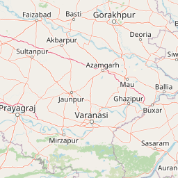
Map view of Parvati Arga Bird Sanctuary

Use this park location map to pinpoint Parvati Arga Bird Sanctuary in India, understand its exact geographic position, and read its mapped placement within the surrounding landscape more clearly.

Pigeon | © OpenStreetMap contributors

Location context for Parvati Arga Bird Sanctuary

Uttar Pradesh
Recorded earthquake history

Review the Earthquake History of Parvati Arga Bird Sanctuary

Explore the documented seismic history of the region surrounding Parvati Arga Bird Sanctuary. This catalogue offers a searchable collection of historical records for those interested in the geographic and seismic context of the sanctuary, powered by reliable datasets provided through MoriAtlas.

Parvati Arga Bird Sanctuary Earthquake History

Catalogued events

1 event

Strongest magnitude

Magnitude 4.7

Most recent event

Dec 5, 1984

This history includes earthquakes recorded inside the park or within 50 km of its borders

Park atlas

Compare regional wetland habitats and connected protected areas across the northern plains.

Exploring Parks Near Parvati Arga Bird Sanctuary and Surrounding Protected Landscapes

Browse other parks near Parvati Arga Bird Sanctuary to examine similar freshwater wetland habitats and regional conservation areas. Comparing connected protected landscapes across the surrounding region reveals broader patterns in regional geography and wildlife distribution.
Wildlife reserveUttar Pradesh
90 km away#1 closest

East

Bakhira Wildlife Sanctuary: Geographic Overview of India's Major Floodplain Wetland

Mapped wetlands and protected landscape context in Uttar Pradesh

Located in the heart of the Indo-Gangetic plain, Bakhira Wildlife Sanctuary features a complex network of seasonal water bodies and marshes. The sanctuary acts as a primary staging ground for migratory waterfowl, offering deep insights into floodplain hydrology, regional biodiversity, and the interplay between protected wilderness and active agricultural zones.

Area
29 km²
Established
1980
IUCN
IV
Relief
Lowland
Wildlife reserveUttar Pradesh
124 km away#2 closest

Southwest

Samaspur Bird Sanctuary: Geographic Overview of Uttar Pradesh Wetland Reserves

Freshwater marshland and migratory bird habitat in North India

Samaspur Bird Sanctuary preserves a series of freshwater jheels and marshes in the central Gangetic plain. This protected area supports an expansive ecosystem of migratory waterfowl and resident species, defining a distinct natural enclave within the agricultural landscape of Raebareli district.

Area
7.994 km²
Established
1987
IUCN
IV
Water
Water-dominated
National parkNepal
About 139 km away#3 closest

North

Banke National Park: Nepal National Park with Distinct Protected Landscape Geography

Explore the mapped terrain and regional atlas context of Banke National Park.

Banke National Park represents a vital protected area within Nepal's diverse geography, offering a focused point for atlas and map-based discovery. As a national park, its designated status highlights its importance in conserving natural landscapes and understanding regional protected-area distribution across South Asia. This entry provides detailed geographic context, enabling users to explore the park's mapped boundaries and appreciate its role within Nepal's broader natural territory.

Area
550 km²
Established
2010
IUCN
II
Relief
Upland
Watercolor illustration of a lush wetland scene with low hills in the background and a winding stream through green fields.
Wildlife reserveUttar Pradesh
148 km away#4 closest

West

Nawabganj Bird Sanctuary: Geographic Overview and Protected Wetland Landscape in Uttar Pradesh

A Ramsar-recognized lake ecosystem and wildlife reserve.

Located in the Unnao district, Nawabganj Bird Sanctuary features a significant freshwater lake that serves as a vital hydrological heart for the region. The sanctuary creates an essential ecological mosaic of reed-fringed water, dry land patches, and woodland edges. This protected landscape plays a foundational role in conservation efforts for migratory waterfowl and resident species on the Indo-Gangetic plain, offering unique insights into wetland terrain mapping.

IUCN
IV
Relief
Lowland
Access
Easy access
Scope
Terrestrial
National parkBardiya District
About 171 km away#5 closest

North

Bardiya National Park: Nepal's Expansive Terai Protected Landscape and Atlas

Mapped geography, tiger habitat, and rhino conservation in Bardiya District.

Bardiya National Park represents a significant protected area within Nepal's Terai lowlands, providing an exceptional resource for geographic discovery. Its diverse terrain, including vast grasslands and dense forests bisected by major river systems like the Karnali and Babai, creates unique ecosystems. As the largest national park in Nepal, it is instrumental in mapping wildlife corridors and understanding regional landscape dynamics, particularly for endangered species such as Bengal tigers and Indian rhinoceroses. This park offers a profound glimpse into the mapped natural heritage of the Bardiya District.

Area
968 km²
Established
1988
IUCN
II
Relief
Mixed relief
National parkNepal
179 km away#6 closest

East

Chitwan National Park: Nepal's Designated National Park Landscape

Explore mapped boundaries and surrounding regional geography.

Chitwan National Park is a vital protected area offering critical insights into Nepal's natural geography. This entry provides detailed information on the park's specific landscape characteristics and its mapped boundaries, crucial for anyone interested in the atlas-level understanding of protected lands within South Asia. Discover the geographic context of this national park and its significance within the broader conservation framework of Nepal.

Area
952.63 km²
Established
1973
IUCN
II
Relief
Mixed relief
National parkLakhimpur Kheri district
200 km away#7 closest

Northwest

Dudhwa National Park: Terai Grasslands and Alluvial Plain Geography within Lakhimpur Kheri

Discover the mapped protected landscape of this vital Indian national park.

Dudhwa National Park in Lakhimpur Kheri district stands as a crucial example of the Terai grassland ecosystem, characterized by its expansive alluvial plains and marshy habitats. This page provides an atlas-style exploration of its protected landscape, detailing the unique terrain and geographic context essential for understanding its conservation significance.

Area
614 km²
Established
1977
IUCN
II
Visitors
26K annual
National parkWest Champaran District
About 201 km away#8 closest

East

Valmiki National Park: A Vital National Park and Protected Landscape in Bihar

Explore unique Sivalik terrain and mapped protected area boundaries

Valmiki National Park, located in the West Champaran District of Bihar, is a significant protected area renowned for its unique geography. Situated at the interface of the Himalayas and the Gangetic plains, the park showcases a varied terrain including ridges, gorges, dense forests, and extensive wetlands. As Bihar's only national park and a designated tiger reserve, it offers rich insights into conservation landscapes and regional biodiversity for atlas exploration.

Area
898.45 km²
Established
1990
IUCN
II
Relief
Mixed relief

Common questions about visiting, size, designation, and location context for Parvati Arga Bird Sanctuary

Parvati Arga Bird Sanctuary FAQs for park facts, access, geography, and protected area context

Find quick answers about Parvati Arga Bird Sanctuary, including protected-area facts, park geography, trail and visitor context, and how the park fits into its surrounding country and regional landscape.
MoriAtlas Explorer

Continue Your Protected Areas Search Across the Global Atlas

Deepen your exploration by continuing the structured search for national parks and protected areas worldwide. Utilize the comprehensive filtering capabilities to compare different conservation landscapes and refine your understanding of global park geography. Discover more about the distribution and characteristics of protected natural areas.

Global natural geography