
Rivers
Park geography
A detailed atlas profile of protected forest landscapes and transboundary mountain terrain
Geography and Mapped Boundaries of the Primeval Beech Forests of the Carpathians and Other Regions of Europe
Analyze the expansive geographic footprint and complex distribution of this protected area covering 583.53 square kilometers. This profile details the mountain relief, temperate broadleaf forest habitats, and key natural landmarks contained within the transboundary range across Europe.

A transnational UNESCO World Heritage network of Europe's surviving primeval and old-growth beech forests
Primeval Beech Forests of the Carpathians and Other Regions of Europe
The Primeval Beech Forests of the Carpathians and Other Regions of Europe form a transnational UNESCO World Heritage Site that unites scattered fragments of the continent's most intact beech forest ecosystems. Stretching across eighteen European countries, the site brings together dozens of individual forest reserves that together illustrate how European beech forests survived the last glaciation and recolonized the continent. Unlike a single conventional national park, this property functions as a collective conservation network. The component sites collectively span a wide range of European phytogeographic zones, from the Illyrian climate of the Balkans to montane beech forests of the Alps, Carpathians, and Dinaric Alps, and relict beech stands on the margins of the Mediterranean region. The inscription is inscribed under UNESCO natural criterion (ix), recognizing the sites as outstanding examples of ongoing ecological and biological processes in terrestrial ecosystems. What makes the property distinctive is its function as a transnational reference for natural beech forest dynamics at a continental scale. By linking together national parks, strict nature reserves, and old-growth forest fragments, it documents the post-glacial spread of European beech (Fagus sylvatica, and related species) and the ecological integrity of forests that have never been logged or have been allowed to return to a wild state.
- Location
- Albania
- Park type
- Protected area
- Established
- 2007
- Area
- 583.5 km²
Location overview
Multinational protected area spanning numerous European nations
Primeval Beech Forests of the Carpathians and Other Regions of Europe Geography
Recorded country memberships span eighteen European nations within a vast multinational protected network. Transboundary administrative structures connect multiple sovereign territories across the continent.
- Countries
- Albania, Austria, Belgium, Bosnia and Herzegovina, Bulgaria, Croatia, Czechia, France, Germany, Italy, North Macedonia, Poland, Romania, Slovakia, Slovenia, Spain, Switzerland, Ukraine
- Regions
- Europe
- Primary location
- Albania
- Geographic setting
- Transboundary · Inland
Boundary and coordinates
Interactive boundary geometry and recorded spatial measurements
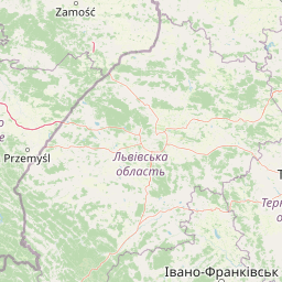
Primeval Beech Forests Boundary Map and Geographic Extent
Mapped park geometry provides clear spatial context for analyzing the protected area. Accompanying facts outline derived area measurements, coordinate limits, and geographic spans.
- Boundary area
- 253.3 km²
- Boundary perimeter
- 446.4 km
- Northernmost point
- 49.9837° N
- Southernmost point
- 47.927° N
- Easternmost point
- 26.2706° E
- Westernmost point
- 23.0796° E
- Geographic centre
- 48.2996° N, 23.906° E
- North–south span
- 228.7 km
- East–west span
- 233.7 km
Terrain and natural features
Mountain relief classifications and recorded natural features across protected zones
Primeval Beech Forests of the Carpathians and Other Regions of Europe Terrain and Natural Features
Mountain terrain classifications shape the protected landscape alongside recorded rivers, peaks, and mountain ranges. Linked feature cards supply names, types, measurements, and spatial relationships across the territory.
Selected named natural features
Rivers
Лужанка
Streams
Черник
Peaks
Перехрестя
961 m
Peaks
Синяк
1,040 m
Mountain ranges
Inner Eastern Carpathians
Environmental setting
Temperate broadleaf forest and mountain relief classifications
Primeval Beech Forests of the Carpathians and Other Regions of Europe Environmental Settings
Recorded landscape features and dominant forest covers frame the physical setting of Primeval Beech Forests of the Carpathians and Other Regions of Europe. Associated categories connect directly to relevant regional atlas destinations.
- Relief
- Mountain
- Water
- Minor water
- Forest cover
- Dense forest cover
Landscape features
Mountains · Forest
Habitat types
Temperate broadleaf forest · Montane forest
Park atlas
Compare adjacent conservation networks, old growth forest reserves, and regional mountain terrain.
Other Parks and Protected Landscapes Near Primeval Beech Forests of the Carpathians and Other Regions of Europe
Browsing other protected areas near Primeval Beech Forests of the Carpathians and Other Regions of Europe reveals broader continental forest dynamics and contiguous ecological zones. Extending the geographic comparison helps trace ancient beech distribution patterns across diverse European mountain ranges and lowland reserves.
National parkLviv Oblast
About 5.1 km away#1 closest
Northeast

Yavoriv National Nature Park: Protected Landscape and Regional Geography in Lviv Oblast
Mapped protected area boundaries and natural terrain context.
Yavoriv National Nature Park is a designated national park within Lviv Oblast, Ukraine. This page provides detailed geographic information, focusing on the park's protected landscape identity and its mapped terrain. Understanding its location in Western Ukraine, near the Carpathian gateway, offers valuable context for atlas-based exploration of protected areas and natural features within the region.
- Area
- 71.08 km²
- Established
- 1998
- IUCN
- II
- Relief
- Highland

National parkZakarpattia Oblast
About 9 km away#2 closest
Southeast
Zacharovanyi Krai National Nature Park: Protected Landscape Atlas Entry
National park within Zakarpattia Oblast, Ukraine
Navigate Zacharovanyi Krai National Nature Park, a designated national park offering vital insights into protected landscapes and regional geography. This entry provides core information about the park's protected area status and its geographic setting within Zakarpattia Oblast, essential for structured atlas discovery and understanding the mapped natural terrain of western Ukraine.
- Area
- 61.01 km²
- Established
- 2009
- IUCN
- II
- Relief
- Mountain
National parkZakarpattia Oblast
About 12 km away#3 closest
Southeast
Synevyr National Nature Park: National Park Protected Landscape in Zakarpattia Oblast
Mapped geographic context and protected area identity
Delve into Synevyr National Nature Park, a designated national park situated in the diverse geography of Zakarpattia Oblast, Ukraine. This page provides essential atlas-driven context, detailing the park's mapped boundaries and its significance as a protected landscape within the Carpathian region. Understand its unique place in Ukraine's network of natural areas and explore its regional geographic setting for a comprehensive overview.
- Area
- 404 km²
- Established
- 1974
- IUCN
- V
- Relief
- Mountain
National parkIvano-Frankivsk Oblast
About 16 km away#4 closest
East
Syniohora National Nature Park: Protected Carpathian Landscape and Geographic Context
Explore the mapped terrain and protected area boundaries within the Gorgany mountains.
Syniohora National Nature Park, located in Ivano-Frankivsk Oblast, is a vital protected area safeguarding a significant portion of the Gorgany mountain massif. This park offers a unique opportunity to explore the mapped geography and natural landscape characteristic of the Ukrainian Carpathians. Its establishment as a national park underscores the importance of preserving the region's mountain terrain, protected forest ecosystems, and distinctive natural heritage for structured geographic discovery.
- Area
- 108.66 km²
- Established
- 2009
- IUCN
- II
- Scope
- Terrestrial
National parkIvano-Frankivsk Oblast
About 18 km away#5 closest
Southeast
Carpathian National Nature Park: Protected Landscape Within Ivano-Frankivsk Oblast
National Park mapped boundaries and regional geography.
Carpathian National Nature Park represents a significant protected area within Ivano-Frankivsk Oblast, Ukraine. This page offers detailed insights into its protected landscape identity, helping users understand its geographic setting and mapped boundaries. As part of the Carpathian region, the park serves as a key point for atlas-based discovery, providing context for its place within the broader geography of western Ukraine.
- Area
- 515.7 km²
- Established
- 1980
- IUCN
- II
- Visitors
- 1M annual
Protected landscapeMaramureș County
About 24 km away#6 closest
Southeast

Maramureș Mountains Natural Park: Protected Landscape and Carpathian Geography
Explore the mapped boundaries and dramatic terrain of Romania's largest nature park.
Delve into the Maramureș Mountains Natural Park, a protected landscape covering extensive tracts of the northern Carpathian Mountains. This page provides detailed geographic context, showcasing the park's mapped boundaries, diverse alpine terrain, and its role within the broader regional geography of Maramureș County. Understand the natural features and protected area significance of this expansive Carpathian wilderness for structured atlas exploration.
- Area
- 1,488.5 km²
- Established
- 2004
- IUCN
- V
- Relief
- Mountain
Protected areaPodkarpackie Voivodeship
30 km away#7 closest
Northeast

Uroczyska Roztocza Wschodniego: Protected Area and Forested Ridge Geography
Extensive forest sanctuary in the Podkarpackie Voivodeship
Uroczyska Roztocza Wschodniego comprises vast, compact forest tracts on the Eastern Roztocze, defined by high-value woodland communities including beech and oak-hornbeam forests. The area functions as a critical protected landscape that supports diverse fauna and complex hydrological corridors within a significant regional conservation network.
- Area
- 58.1 km²
- Established
- 2011
- Relief
- Upland
- Climate
- Temperate
National parkVerkhovyna Raion
About 34 km away#8 closest
Southeast
Verkhovyna National Nature Park: Explore Protected Landscape Geography in Verkhovyna Raion
Discover Ukraine's Verkhovyna National Nature Park mapped terrain.
Verkhovyna National Nature Park represents a vital protected area within the Verkhovyna Raion of Ukraine. This detailed atlas entry focuses on the park's geographic significance, providing insights into its mapped boundaries and its role within the regional landscape context of the Carpathian Mountains. It serves as a focused point for understanding the park's protected status and its place in a structured geographic discovery framework.
- Area
- 120 km²
- Established
- 2010
- IUCN
- II
- Relief
- Mountain
MoriAtlas Explorer
Explore the Primeval Beech Forests of the Carpathians and Other Regions of Europe Geographic Network
Trace the interconnected fragments of the Primeval Beech Forests of the Carpathians and Other Regions of Europe. MoriAtlas provides a comprehensive view of these protected forest reserves, revealing the vital ecological gradients and natural forest dynamics that define this extensive European landscape.
Browse next
Global natural geography
Explore related park routes
Explore MoriAtlas Global ParksBrowse All MoriAtlas ParksGlobal Park Map DiscoveryMoriAtlas: Browse All CountriesBrowse All MoriAtlas ContinentsNational Park Environment AtlasGrand Canyon National Park AtlasYellowstone National Park AtlasYosemite National Park Atlas and GeographySerengeti National Park AtlasGalápagos National Park Protected LandscapeBanff National Park Geography and AtlasKruger National Park Atlas EntryUluṟu-Kata Tjuṯa National Park AtlasExplore Uluru-Kata Tjuta National Park GeographyPlitvice Lakes National Park AtlasFiordland National Park Protected LandscapeGreat Smoky Mountains National Park AtlasAfghanistan National Parks and Protected AreasAlbania National Parks and Protected AreasAlgeria National Parks and Protected AreasAmerican Samoa National Parks and Protected AreasAndorra National Parks and Protected AreasAngola National Parks and Protected AreasAntarctica National Parks and Protected AreasAntigua and Barbuda Park List