
Mori Atlas logo
Nature reserveRéserve naturelle régionale des éboulis et pelouses calcaires de Pagny-la-Blanche-Côte et Champougny

A detailed map and atlas overview of limestone habitats within the Grand Est region of France

Réserve naturelle régionale des éboulis et pelouses calcaires de Pagny-la-Blanche-Côte et Champougny: Geographic Protected Area Detail

(Réserve naturelle régionale des éboulis et pelouses calcaires de Pagny-la-Blanche-Côte et Champougny (RNR331))

The Réserve naturelle régionale des éboulis et pelouses calcaires de Pagny-la-Blanche-Côte et Champougny preserves 49 hectares of distinct geological terrain across the communes of Champougny and Pagny-la-Blanche-Côte. This protected area safeguards specific limestone scree slopes and dry calcareous grasslands that characterize the landscape of the Meuse department. Through detailed mapping and atlas data, gain insight into the conservation of these fragmented habitats and the broader topographical features defining the regional nature reserve network.

limestone screecalcareous grasslandsregional nature reserveMeuseGrand Estlimestone habitats
A digital illustration in a flat, graphic style depicting a lush mountain valley, featuring tall cliffs, a waterfall dropping from a canyon wall, a winding river, and a foreground of coniferous trees under a soft, pastel-toned sky.

Réserve naturelle régionale des éboulis et pelouses calcaires de Pagny-la-Blanche-Côte et Champougny

Nature reserve

Park overview

Structured park overview, official facts, and landscape profile for Réserve naturelle régionale des éboulis et pelouses calcaires de Pagny-la-Blanche-Côte et Champougny

Réserve naturelle régionale des éboulis et pelouses calcaires de Pagny-la-Blanche-Côte et Champougny park facts, protected area profile, and essential visitor context

Review the core facts for Réserve naturelle régionale des éboulis et pelouses calcaires de Pagny-la-Blanche-Côte et Champougny, including designation, size, terrain, visitor scale, habitats, and operating context in one park-focused overview.

About Réserve naturelle régionale des éboulis et pelouses calcaires de Pagny-la-Blanche-Côte et Champougny

The Réserve naturelle régionale des éboulis et pelouses calcaires de Pagny-la-Blanche-Côte et Champougny is a recent addition to France's network of regional nature reserves. Established in January 2021, it focuses on a compact but ecologically significant stretch of limestone landscape in the Meuse, where the underlying geology shapes both the scenery and the biological communities found there.

Geographically, the site straddles the communes of Champougny and Pagny-la-Blanche-Côte, two small localities set among the agricultural and wooded landscapes characteristic of the Meuse department. The reserve lies within the broader Grand Est administrative region, which was formed in 2016 through the merger of Alsace, Champagne-Ardenne, and Lorraine. Within this larger region, the Meuse represents one of the more rural, sparsely populated departments, where large expanses of farmland, forest, and limestone plateau alternate across the countryside.

The defining feature of the reserve is the presence of limestone scree slopes: accumulations of broken rock fragments produced by the natural erosion of the limestone bedrock. Paired with these screes are calcareous grasslands, open plant communities that develop on thin, dry soils directly over limestone. Together, these two habitat types form a continuum that is relatively rare in modern French landscapes, where such open calcareous environments have largely been lost to agricultural intensification, reforestation, or urban development. The reserve's name deliberately emphasizes this dual focus on both landforms (éboulis) and vegetation (pelouses calcaires).

As a regional nature reserve, the site operates under the French legal framework for regional reserves, which grants the Regional Council the authority to establish protections for sites of ecological interest at a subnational level. The reserve has the designation RNR331, reflecting its place within the national numbering of French regional nature reserves. It is recognized at the international level through its inclusion in the World Database on Protected Areas and its assignment to IUCN Category IV. This category indicates a protected area managed primarily for the conservation of specific habitats and species, through active intervention when needed to maintain the habitats in a favorable condition.

Management of the reserve is entrusted to a conservatoire d'espaces naturels, reflecting a common pattern in French regional nature reserves where specialized nonprofit bodies take on day-to-day stewardship responsibilities. These conservatoires typically handle habitat monitoring, conservation actions, public engagement, and coordination with local landowners and municipalities. Although the reserve is small in area, its organizational structure follows the same institutional model applied to larger French natural protected sites, ensuring consistent governance, monitoring, and reporting.

The reserve does not aim to replicate the wilderness experience of larger national parks. Instead, its role is more targeted: to preserve a fragment of the local calcareous landscape that would otherwise be vulnerable to the pressures of changing land use. In doing so, it contributes to the broader effort to maintain ecological connectivity and habitat diversity across the Grand Est, where limestone habitats form one of the defining ecological features of the region.

Quick facts and research context for Réserve naturelle régionale des éboulis et pelouses calcaires de Pagny-la-Blanche-Côte et Champougny

The Réserve naturelle régionale des éboulis et pelouses calcaires de Pagny-la-Blanche-Côte et Champougny is a regional nature reserve (réserve naturelle régionale) classified in France on 21 January 2021 by a deliberation of the Regional Council. It lies within the Grand Est region and is administratively part of the Meuse department, spanning two communes: Champougny and Pagny-la-Blanche-Côte.

The reserve covers around 49 hectares and is catalogued under the identifier RNR331. Its IUCN protected-area category is IV, identifying it as a habitat and species management area. It is managed by a conservatoire d'espaces naturels, an organization specialized in the long-term stewardship of natural environments in France.

Protection and recognition

A 2021 regional nature reserve with Category IV and WDPA records

Pagny-la-Blanche-Côte and Champougny nature reserve protection status

The Réserve naturelle régionale des éboulis et pelouses calcaires de Pagny-la-Blanche-Côte et Champougny is documented as a French nature reserve established in 2021. Its profile brings the regional designation together with IUCN Category IV and a WDPA reference while avoiding claims about legal effects or conservation performance.

Protection details

WDPA ID
555737965
Park context

Deeper park guide and search-rich context for Réserve naturelle régionale des éboulis et pelouses calcaires de Pagny-la-Blanche-Côte et Champougny

Réserve naturelle régionale des éboulis et pelouses calcaires de Pagny-la-Blanche-Côte et Champougny history, landscape, wildlife, and travel context

Explore Réserve naturelle régionale des éboulis et pelouses calcaires de Pagny-la-Blanche-Côte et Champougny through its history, landscape character, ecosystems, wildlife, conservation priorities, cultural context, and seasonal travel timing in a structured park guide built for atlas discovery and search intent.

Why Réserve naturelle régionale des éboulis et pelouses calcaires de Pagny-la-Blanche-Côte et Champougny stands out

The reserve is best known for protecting two closely linked calcareous habitat types of the Meuse: limestone scree slopes and dry calcareous grasslands. These open, rocky environments, set against the limestone plateaus of Lorraine, provide the structural and ecological conditions that the reserve was established to safeguard. Its identity is tightly tied to the geological character of the local terrain, where exposed Jurassic limestone gives rise to fragmented rocky slopes and thin, species-rich grassland communities. The regional nature reserve classification highlights the value of these habitats, which are otherwise vulnerable to scrub encroachment, changes in land use, and the general loss of open calcareous environments in northeastern France.
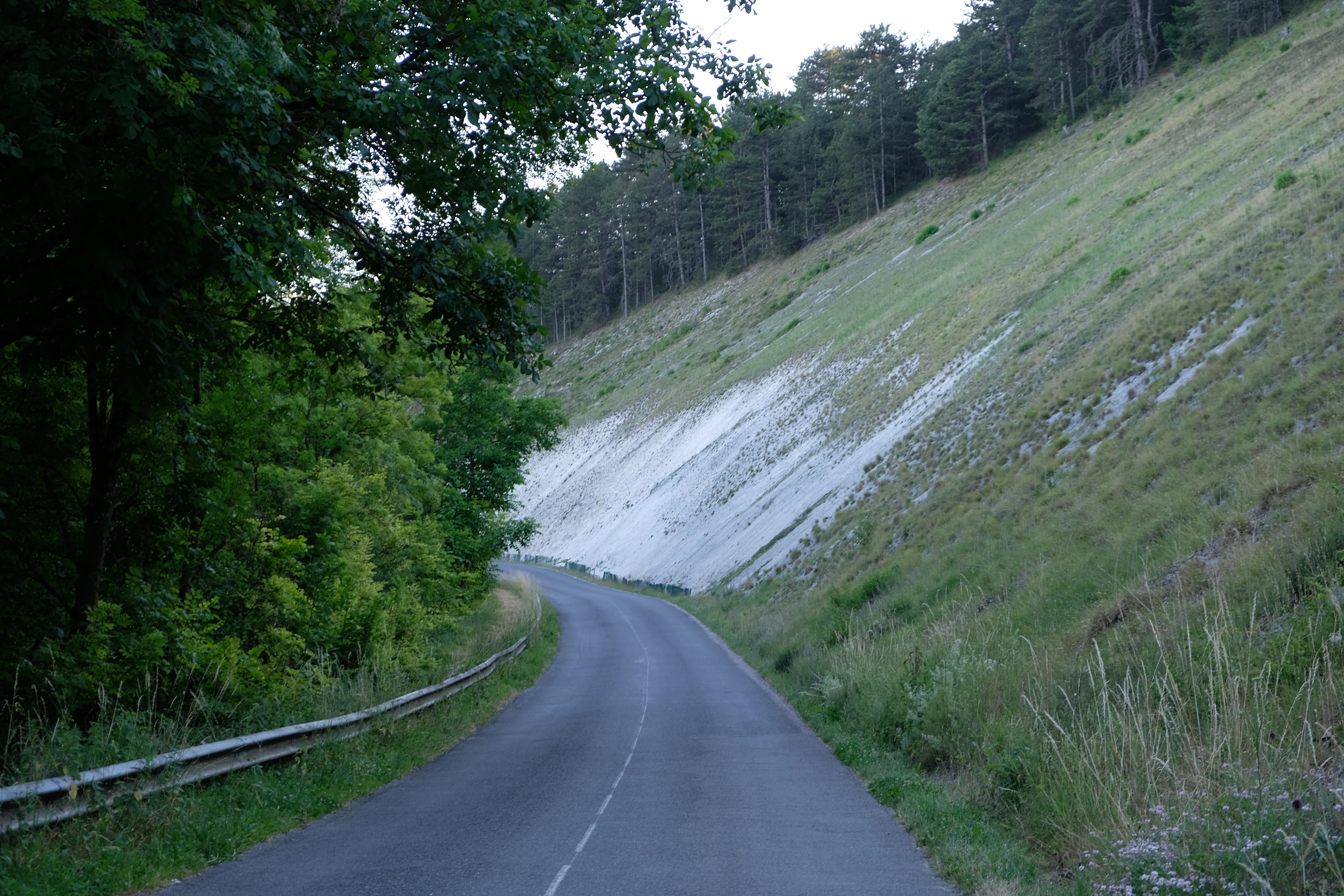
A paved road curving along the base of a steep, grassy limestone scree slope in a rural area, with forest lining the opposite side.
A road passing by the limestone scree slopes of the Blanche Côte, a defining geological feature of the nature reserve.

Réserve naturelle régionale des éboulis et pelouses calcaires de Pagny-la-Blanche-Côte et Champougny history and protected-area timeline

The reserve is a recent creation in the French network of protected natural areas. It was formally established on 21 January 2021 through a deliberation of the Conseil régional, the Regional Council of Grand Est. This official act of classification is the founding legal moment of the reserve, conferring it the status of a regional nature reserve and the identification number RNR331.

The relatively recent date of classification reflects a wider trend in French conservation policy, where regional nature reserves have increasingly been used as a flexible tool to protect locally significant natural areas that may not fit within the boundaries of national parks or stricter national reserves. By creating this reserve, the Grand Est regional authorities recognized the ecological value of the limestone scree and calcareous grassland habitats around Pagny-la-Blanche-Côte and Champougny.

The article notes that the historical section of the Wikipedia entry was incomplete at the time of source capture, so detailed background on pre-classification land use, prior conservation activity, or earlier protection initiatives is not available from the source material. The key historical facts that can be stated with confidence are the date and mechanism of official creation, along with the institutional context of regional nature reserves in France.

Réserve naturelle régionale des éboulis et pelouses calcaires de Pagny-la-Blanche-Côte et Champougny landscape and geographic character

The landscape of the reserve is defined by limestone, specifically the eroded, broken, and exposed forms that geologists and naturalists recognize as characteristic of calcareous plateaus in Lorraine. The most visually distinctive feature is the presence of éboulis calcaires, or limestone scree slopes: accumulations of angular rock fragments that have detached from the parent limestone bedrock over time through processes of frost weathering, gravity, and surface erosion. These screes create fragmented, uneven terrain with rocks of varying sizes, often sparsely vegetated and difficult to walk across.

Interleaved with the screes are the pelouses calcaires, dry calcareous grasslands that occupy the more stable, soil-bearing parts of the slope. These grasslands are typically open, low-growing, and species-rich, with a plant community adapted to thin, well-drained, alkaline soils. In many parts of northeastern France, such grasslands have been historically maintained through grazing, and their modern survival depends on continued low-intensity land use or active conservation management.

The overall impression of the reserve's landscape is one of geological exposure and ecological openness. The scenery is neither dense forest nor cultivated field, but rather a transitional, semi-open environment where rock and vegetation alternate in close proximity. This kind of terrain is broadly characteristic of the limestone landscapes of the Meuse, where Jurassic-age formations have shaped both surface topography and human settlement patterns.

The reserve's perimeter follows the actual extent of these scree and grassland habitats, as illustrated in the reserve's perimeter map. The small total area, around 49 hectares, indicates that the protected zone is tightly drawn around the specific landforms and vegetation communities of interest, rather than encompassing a wider landscape mosaic.

Réserve naturelle régionale des éboulis et pelouses calcaires de Pagny-la-Blanche-Côte et Champougny ecosystems, habitats, and plant life

The nature of the reserve is inseparably linked to the chemistry and structure of the limestone substrate. Calcareous scree slopes and dry calcareous grasslands form a habitat pair that supports a particular kind of biodiversity: species adapted to thin, alkaline, drought-prone soils, to rocky microhabitats, and to the open conditions that these habitats provide.

In ecological terms, the calcareous grasslands of the type protected here are known across Europe for their high botanical diversity, often harboring rare or specialized plant species, orchids, and characteristic herbaceous communities. These grasslands tend to occupy south-facing or otherwise sun-exposed slopes, where the combination of shallow soil and limestone bedrock creates warm, dry conditions favorable to specialist plants. The scree slopes, while more sparsely vegetated, contribute additional microhabitat diversity, with plants and invertebrates colonizing the spaces between rock fragments.

The reserve's ecological value is enhanced by the fact that these two habitat types are protected together within a single site. This continuity allows ecological processes linking rocks, soils, and vegetation to be maintained, rather than fragmenting the landscape into isolated patches. From a regional perspective, the reserve contributes to the conservation of calcareous habitats that have a limited distribution in the modern agricultural landscape of the Meuse and the wider Grand Est region.

The article's ecology sections in the source were empty or marked as incomplete, so specific species lists, vegetation classifications, and detailed biodiversity statistics are not available. The general ecological character described above reflects what is well established about calcareous scree and grassland habitats in this part of France, but any precise species-level information would require additional sources beyond the provided Wikipedia article.

Réserve naturelle régionale des éboulis et pelouses calcaires de Pagny-la-Blanche-Côte et Champougny wildlife and species highlights

The wildlife associated with limestone scree and calcareous grassland habitats in the Meuse typically includes a distinctive mix of invertebrates, reptiles, birds, and small mammals adapted to warm, open, stony environments. Rocky slopes and open grasslands provide basking sites for reptiles, hunting grounds for birds of prey, and foraging habitat for pollinators that depend on the rich flowering plants of calcareous grasslands.

Open, sun-exposed grasslands are particularly important for invertebrate diversity, including butterflies, bees, and other pollinators whose ecological cycles are closely tied to the flowering patterns of specialized calcareous plants. The structural diversity of scree slopes also supports species that find refuge between and beneath rock fragments, including a range of ground-dwelling invertebrates and, at a larger scale, reptiles and small mammals.

The article's fauna section in the source was empty or marked as incomplete, so specific confirmed species records for this reserve are not available from the provided material. Wildlife content has therefore been kept general, in line with the well-known ecological associations of calcareous scree and grassland habitats, without inventing specific species or records not directly supported by the source.

Réserve naturelle régionale des éboulis et pelouses calcaires de Pagny-la-Blanche-Côte et Champougny conservation status and protection priorities

The conservation significance of the reserve lies in the protection of two habitat types that are both ecologically distinctive and historically vulnerable in northeastern France: limestone scree slopes and calcareous grasslands. These habitats have long been shaped by low-intensity human activity, including grazing, and their modern persistence depends on active protection against the pressures of land change.

The reserve's IUCN Category IV designation indicates that its management objectives are oriented toward the conservation of specific habitats and species, rather than the preservation of a large-scale natural ecosystem. This is consistent with its role as a small, habitat-focused protected area within a broader French conservation framework. The classification as a regional nature reserve placed it into a legal framework that provides specific protections for the site's habitats, flora, and fauna, and that supports targeted management actions.

Management responsibility is assigned to a conservatoire d'espaces naturels, which typically undertakes habitat monitoring, conservation management work, and stakeholder engagement. Through this arrangement, the reserve benefits from continuity of expert management and integration into wider regional conservation networks.

At a regional level, the reserve contributes to the broader effort to maintain calcareous habitats across the Grand Est, where limestone geology produces a recurring pattern of karst landscapes, dry grasslands, and species-rich plant communities. By safeguarding a representative fragment of these habitats in the Meuse, the reserve participates in the long-term conservation of one of the defining ecological systems of northeastern France.

Réserve naturelle régionale des éboulis et pelouses calcaires de Pagny-la-Blanche-Côte et Champougny cultural meaning and human context

The reserve is set within the rural landscape of the Meuse, a department historically shaped by agriculture and by the geological character of its limestone plateaus. The two communes named in the reserve's title, Pagny-la-Blanche-Côte and Champougny, are small villages embedded in this regional context, where settlement has historically adapted to the pattern of limestone ridges, valleys, and agricultural land.

The name 'Pagny-la-Blanche-Côte' itself translates roughly as 'Pagny of the White Slope', a reference to the pale limestone escarpments that dominate the local terrain. This linguistic clue reflects the close relationship between human place names and the underlying geological and landscape features of the Meuse. The reserve's protection thus indirectly recognizes the cultural landscape identity of these villages and the long human presence in these limestone environments.

No further specific cultural or historical detail was available from the source material about local traditions, heritage sites within the reserve, or indigenous or historical land-use practices specific to the reserve's territory. Cultural context here is therefore kept broad and grounded only in what the source and the place names directly support.

Top sights and standout views in Réserve naturelle régionale des éboulis et pelouses calcaires de Pagny-la-Blanche-Côte et Champougny

The reserve's most striking highlights are its limestone scree slopes and its dry calcareous grasslands: two habitat types that together define the character of the site. These are supported by a compact protected area of around 49 hectares, drawing a tight perimeter around the specific landforms and vegetation communities of interest.

Equally notable is the reserve's institutional profile: a regional nature reserve classified in 2021 under the authority of the Grand Est Regional Council, classified as IUCN Category IV, and entrusted to a conservatoire d'espaces naturels for its ongoing management. These features make it a small but structurally complete example of the French regional nature reserve model.

Best time to visit Réserve naturelle régionale des éboulis et pelouses calcaires de Pagny-la-Blanche-Côte et Champougny

Open calcareous grasslands and limestone habitats in the Meuse are best appreciated during late spring and summer, when calcareous plant communities reach peak flowering and the dry, sun-exposed character of the landscape is most apparent. Wildflower diversity in these habitats is typically richest from May through July, and warm, dry conditions also favor visibility of pollinators and reptiles typical of these open environments.

Conversely, autumn and winter reveal a different character, with dormant grassland vegetation, exposed rocky surfaces, and clearer visibility of the underlying geological structure of the scree slopes. The compact size of the reserve means that visits are necessarily short, and the site's value lies in close observation of small-scale landscape features rather than in extensive touring.

As the source does not provide any information on visitor access, infrastructure, or seasonal restrictions, specific practical guidance on opening, trails, or visitor facilities is not offered here.

Monthly climate preview

Twelve-month temperature and precipitation evidence from one reserve coordinate

Pagny-la-Blanche-Côte and Champougny monthly climate normals

The Pagny-la-Blanche-Côte and Champougny scree and calcareous-grassland reserve has 1991–2020 climate normals from a representative coordinate near 326 metres. Its full monthly profile separates mean, minimum, and maximum temperatures from daily precipitation, providing measured context without generalizing across every slope or exposure.
Annual mean9 °C
1 °C18 °C
Jan
Feb
Mar
Apr
May13°
Jun16°
Jul18°
Aug18°
Sep14°
Oct10°
Nov
Dec
Warmest month
July

18.5 °C

Coolest month
January

0.8 °C

Wettest month
December

2.7 mm/day

Driest month
April

1.8 mm/day

Park location guide

Geography guide, regional context, and park location map for Réserve naturelle régionale des éboulis et pelouses calcaires de Pagny-la-Blanche-Côte et Champougny

Réserve naturelle régionale des éboulis et pelouses calcaires de Pagny-la-Blanche-Côte et Champougny park geography, regions, and map view in France

Understand where Réserve naturelle régionale des éboulis et pelouses calcaires de Pagny-la-Blanche-Côte et Champougny sits in France through a broader geographic reading of the surrounding landscape, nearby location context, and its mapped position within the national park landscape.

How Réserve naturelle régionale des éboulis et pelouses calcaires de Pagny-la-Blanche-Côte et Champougny fits into France

France is a unitary semi-presidential republic and one of the world's largest economies. It borders Belgium, Luxembourg, Germany, Switzerland, Italy, Monaco, Andorra, and Spain, with a maritime border to the United Kingdom. The country is known for its cultural influence, art, cuisine, and political history spanning centuries.

Wider geography shaping Réserve naturelle régionale des éboulis et pelouses calcaires de Pagny-la-Blanche-Côte et Champougny in France

France is located in Western Europe. Metropolitan France extends from the Rhine to the Atlantic Ocean and from the Mediterranean Sea to the English Channel and North Sea. The country borders Belgium, Luxembourg, Germany, Switzerland, Italy, Monaco, Andorra, Spain, and has a maritime border with the United Kingdom.

Map view of Réserve naturelle régionale des éboulis et pelouses calcaires de Pagny-la-Blanche-Côte et Champougny

Use this park location map to pinpoint Réserve naturelle régionale des éboulis et pelouses calcaires de Pagny-la-Blanche-Côte et Champougny in France, understand its exact geographic position, and read its mapped placement within the surrounding landscape more clearly.

Pigeon | © OpenStreetMap contributors

Location context for Réserve naturelle régionale des éboulis et pelouses calcaires de Pagny-la-Blanche-Côte et Champougny

Grand Est

Visualizing limestone scree slopes, calcareous grasslands, and protected terrain in the Grand Est region

Réserve naturelle régionale des éboulis et pelouses calcaires de Pagny-la-Blanche-Côte et Champougny Photos and Protected Landscapes

Visual documentation reveals the limestone scree slopes, calcareous grasslands, and rocky terrain that define the protected environment of Réserve naturelle régionale des éboulis et pelouses calcaires de Pagny-la-Blanche-Côte et Champougny. Studying these habitats through field photography provides clear insight into the fragile natural communities and geological formations preserved across the Meuse landscape.

A paved road curving along the base of a steep, grassy limestone scree slope in a rural area, with forest lining the opposite side.

Park atlas

Compare adjacent limestone landscapes and protected regional nature reserves across the surrounding territory

Parks Near Réserve naturelle régionale des éboulis et pelouses calcaires de Pagny-la-Blanche-Côte et Champougny

Browsing nearby protected areas allows visitors to compare similar limestone scree slopes and dry calcareous grasslands across the wider Meuse territory. Extending the geographic scope helps contextualize regional nature reserves and regional conservation networks.
Watercolor illustration showing a winding river, green riparian trees, and soft, rolling hills in the background.
Nature reserveGrand Est
About 44 km away#1 closest

East

Réserve naturelle régionale de la Moselle sauvage: Geography and Protected River Boundaries

A dynamic alluvial nature reserve in the Grand Est region of France.

Analyze the terrain of the Réserve naturelle régionale de la Moselle sauvage, a protected area shaped by the natural movement of the Moselle river. The reserve encompasses vital floodplain ecosystems including sandy grasslands, wet meadows, and riparian woodlands, functioning as a primary ecological network within the Lorraine landscape.

Area
3.81 km²
Established
2006
IUCN
IV
A watercolor painting showing a soft, panoramic view of a marshland with a winding stream, a small island of reeds, and distant trees on a pale background.
Nature reserveGrand Est
About 54 km away#2 closest

North

Réserve naturelle régionale de Lachaussée: Geography, Wetlands, and Protected Map Data

Protected landscape and historic pond geography in the Meuse department

Focusing on the Étang de Lachaussée, this entry maps the protected boundaries and wetland terrain of a significant regional nature reserve in northeastern France. Observe the intersection of medieval engineering and contemporary ecological conservation through a detailed look at the pond, reedbeds, and surrounding mosaic of habitats that define the Woëvre plain landscape.

Area
6.072 km²
Established
2009
IUCN
IV
Relief
Lowland
Nature reserveGrand Est
About 63 km away#3 closest

Northeast

Réserve naturelle régionale de la côte de Delme: Protected Limestone Outlier and Grassland

Regional nature reserve in the Grand Est department of Moselle

Located in northeastern France, the Réserve naturelle régionale de la côte de Delme features a prominent Jurassic limestone hill known as a butte témoin. This protected area offers a rare glimpse into specialized calcareous grassland habitats, maintained through long-standing grazing traditions and dedicated conservation management across its diverse rocky slopes and open meadows.

Area
1.05 km²
Established
2007
IUCN
IV
Relief
Upland
A soft, horizontal watercolor painting depicting a calm wetland landscape with grassy banks, distant forested hills, and a pale, misty sky.
Nature reserveFrance
About 70 km away#4 closest

Northwest

Réserve naturelle régionale des étangs de Belval-en-Argonne: Protected Area and Wetland Geography

Mapped pond systems in the Marne department of France.

This protected area features a unique mosaic of five historic pond basins set within a gentle plateau landscape. The site is a cornerstone of the Champagne humide wetland system, defined by its interconnected open water, reedbed margins, and wet woodland habitats that support diverse waterbird and amphibian populations across the Argonne region.

Area
2.037 km²
Established
2012
Relief
Lowland
Climate
Temperate
A horizontal watercolor illustration featuring a soft green and yellow landscape of a pond and wetland area with shrubs and meadow grass.
Nature reserveGrand Est
About 72 km away#5 closest

West

Réserve naturelle régionale de l'étang et prairie humide des Paquis: Regional Nature Reserve Geography

Wetland habitat mapping in the Marne department of Grand Est, France

This regional nature reserve encompasses a compact 8.31 hectare wetland complex comprising an étang and a surrounding prairie humide. Its significance lies in its role as a concentrated biodiversity node amidst the open agricultural landscape of the Champagne region, managed primarily for habitat conservation and avian protection.

Area
0.083 km²
Established
2014
IUCN
IV
Nature reserveHaute-Marne
About 73 km away#6 closest

Tufière de Rolampont Nature Reserve: Travertine Cascades and Geological Heritage in Haute-Marne

A rare living limestone formation in the Grand Est region of France

Tufière de Rolampont offers a window into the evolution of calcareous wetland ecosystems within the Champagne plateau. Visitors observe a process of natural stone creation where mineral-rich water encrusts living mosses, resulting in the stepped terraces that define this protected landscape. This site serves as a vital laboratory for understanding the intersection of hydrological heritage and unique botanical habitats.

Area
0.126 km²
Established
1982
Relief
Lowland
Climate
Temperate
Watercolor illustration of a forested landscape with rolling hills, distant mountains, and a sky with soft pastel colors
National parkFrance
About 75 km away#7 closest

Southwest

Forêts National Park: A Protected Landscape of Lowland Deciduous Forests

Explore its unique geography and protected forest ecosystems.

Delve into Forêts National Park, a significant protected area in northeastern France dedicated to preserving lowland deciduous forests and their associated biodiversity. This park represents a unique atlas entry for understanding mapped protected lands, featuring extensive broad-leaved forest tracts, diverse wetlands, and limestone grasslands across the Grand Est and Bourgogne-Franche-Comté regions. Discover the geographic identity of this conservation landscape and its role within the Paris Basin's terrain.

Area
560 km²
Established
2019
IUCN
II
Relief
Lowland
A soft watercolor painting of a wide, peaceful pond surrounded by gentle hills, trees, and marshy wetlands in a muted color palette.
Nature reserveGrand Est
About 81 km away#8 closest

North

Réserve naturelle régionale de l'étang d'Amel: Protected Wetland Geography in Grand Est

Exploring the landscape and habitat history of France's first regional nature reserve

Spanning 147 hectares in the Meuse department, Réserve naturelle régionale de l'étang d'Amel provides a detailed look at a traditional Lorraine pond ecosystem. The site features a mix of reedbeds, marshes, and meadows that offer a sanctuary for protected bird and amphibian species. As a foundational project for French regional conservation, the reserve remains a vital case study in maintaining natural wetland structure within a managed agricultural landscape.

Area
1.47 km²
Established
2006
IUCN
IV

Common questions about visiting, size, designation, and location context for Réserve naturelle régionale des éboulis et pelouses calcaires de Pagny-la-Blanche-Côte et Champougny

Réserve naturelle régionale des éboulis et pelouses calcaires de Pagny-la-Blanche-Côte et Champougny FAQs for park facts, access, geography, and protected area context

Find quick answers about Réserve naturelle régionale des éboulis et pelouses calcaires de Pagny-la-Blanche-Côte et Champougny, including protected-area facts, park geography, trail and visitor context, and how the park fits into its surrounding country and regional landscape.
MoriAtlas Explorer

Continue Your Protected Areas Search Across the Global Atlas

Deepen your exploration by continuing the structured search for national parks and protected areas worldwide. Utilize the comprehensive filtering capabilities to compare different conservation landscapes and refine your understanding of global park geography. Discover more about the distribution and characteristics of protected natural areas.

Global natural geography