
Mori Atlas logo
Nature reserveRéserve naturelle régionale du Molinet

Mapping the Ecological Significance and Limestone Terrain of this Pas-de-Calais Habitat Mosaic

Réserve naturelle régionale du Molinet: A Compact Protected Landscape in Northern France

Located within the broader Parc naturel régional des Caps et Marais d'Opale, the Réserve naturelle régionale du Molinet functions as a critical protected refuge for calcareous woodland and grassland habitats. This small but ecologically significant site in the Pas-de-Calais department provides essential water catchment protection while supporting a dense concentration of rare flora species adapted to its unique limestone soil structure.

regional nature reservecalcareous woodlandcalcareous grasslandpelouse calcicoleBoulonnaisPas-de-Calais
Stylized vector illustration showing a mountainous valley with a two-tiered waterfall, surrounding forests, and a meadow in the foreground.

Réserve naturelle régionale du Molinet

Nature reserve

Park overview

Structured park overview, official facts, and landscape profile for Réserve naturelle régionale du Molinet

Réserve naturelle régionale du Molinet park facts, protected area profile, and essential visitor context

Review the core facts for Réserve naturelle régionale du Molinet, including designation, size, terrain, visitor scale, habitats, and operating context in one park-focused overview.

About Réserve naturelle régionale du Molinet

The Réserve naturelle régionale du Molinet sits in the western part of the Pas-de-Calais, in the historical Boulonnais region. Although its surface is modest, the reserve represents a significant patch of seminatural habitat in a department otherwise dominated by intensive agriculture and urban development. Its siting within the Parc naturel régional des Caps et Marais d'Opale integrates it into a broader network of protected natural spaces along the northern French coast.

The reserve's main ecological value lies in the combination of habitats it conserves. The calcareous woodlands are typical of the limestone substrates of the Boulonnais interior, while the associated calcareous grasslands, or pelouses calcicoles, support a distinctive flora adapted to thin, dry, lime-rich soils. Together these habitats provide a refuge for plant and animal species that have largely disappeared from the more heavily managed surrounding countryside.

Alongside its biodiversity role, the reserve carries an important functional role by serving as the protection perimeter, or périmètre de protection, for a water catchment that supplies part of the Boulogne-sur-Mer urban area. This dual ecological and hydrological function underlines the importance of maintaining the ecological integrity of even very small protected sites in this part of northern France.

Quick facts and research context for Réserve naturelle régionale du Molinet

The Réserve naturelle régionale du Molinet is a regional nature reserve in the Pas-de-Calais, in the Hauts-de-France region of northern France. It was first established as a voluntary nature reserve on 13 July 1987 and was reclassified as a regional nature reserve on 5 October 2009 by decision of the regional council.

The reserve covers roughly 6.72 hectares on the commune of Samer, at the boundary with Longfossé, and lies within the Parc naturel régional des Caps et Marais d'Opale. It is managed by the Conservatoire d'espaces naturels du Nord et du Pas-de-Calais and is classified under IUCN Category IV as a habitat or species management area.

Protection and recognition

Documented terrestrial protection metrics, designation year, and international recognition scope

Protection Status and Designation History for Réserve naturelle régionale du Molinet

Terrestrial protection status for Réserve naturelle régionale du Molinet establishes a documented designation baseline dating from 2009. Structured records organize official protection metrics and associated recognition data for conservation analysis.

Protection details

Protection scope
Terrestrial
Designated year
2009
Transboundary protection
No
WDPA ID
555514389
Park context

Deeper park guide and search-rich context for Réserve naturelle régionale du Molinet

Réserve naturelle régionale du Molinet history, landscape, wildlife, and travel context

Explore Réserve naturelle régionale du Molinet through its history, landscape character, ecosystems, wildlife, conservation priorities, cultural context, and seasonal travel timing in a structured park guide built for atlas discovery and search intent.

Why Réserve naturelle régionale du Molinet stands out

The Molinet reserve is distinguished by its combination of calcareous woodlands and calcareous grasslands on a very small surface area. The site is particularly valued for the diversity of its flora in a compact setting, hosting close to 180 plant species, of which around 23 are considered to be of patrimonial interest. Characteristic species include the spatula-leaved ragwort, Müller's helleborine, the marsh grass of Parnassus, and the meadow cow-wheat, which together reflect the specific ecological conditions offered by the limestone soils. The reserve is also notable for functioning as the protection perimeter for a water catchment serving part of the Boulogne-sur-Mer urban area, linking conservation with drinking water protection.
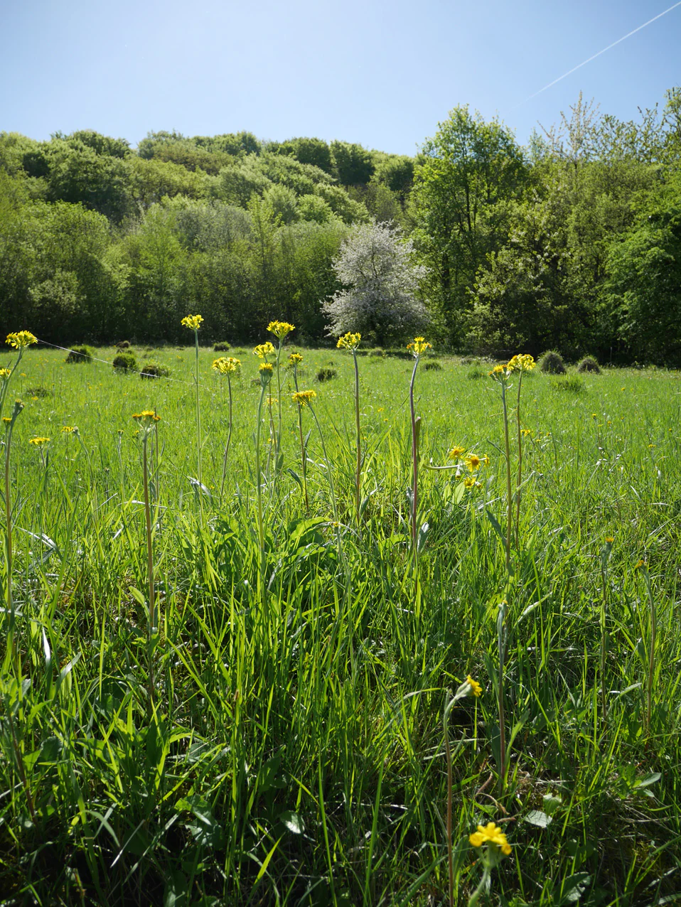
A meadow filled with green grass and yellow Tephroseris helenitis wildflowers, with a backdrop of a lush green forest under a clear blue sky.
Tephroseris helenitis blooming in a meadow within the Réserve naturelle régionale du Molinet.

Réserve naturelle régionale du Molinet history and protected-area timeline

The Molinet site first received formal recognition as a voluntary nature reserve, or réserve naturelle volontaire, on 13 July 1987. This initial designation provided a first layer of protection for the calcareous woodlands and grasslands at the site. The name of the reserve derives from the nearby Château du Grand Molinet, an 18th-century estate that gives the area its local toponym.

The reserve's status was upgraded on 5 October 2009, when the Regional Council adopted a deliberation classifying it as a regional nature reserve, or réserve naturelle régionale. This reclassification was granted for a renewable period of ten years and brought the site under the broader French framework of regional nature reserves.

Réserve naturelle régionale du Molinet landscape and geographic character

The reserve occupies a small but topographically distinct position in the Pas-de-Calais interior, near the town of Samer. The terrain reflects the limestone geology of the Boulonnais, supporting thin, well-drained soils that in turn favor calcareous woodland and open calcareous grassland formations. These two habitat types together define the structural character of the site.

Because of its compact size, the reserve reads as an island of seminatural vegetation within a wider matrix of cultivated fields, meadows, and small settlements. Its visual rhythm shifts with the seasons: the woodlands offer denser, more enclosed scenery, while the open grasslands give broader, lighter views across the calcareous substrate. This small-scale contrast between wood and open ground is one of the defining landscape traits of the Molinet reserve.
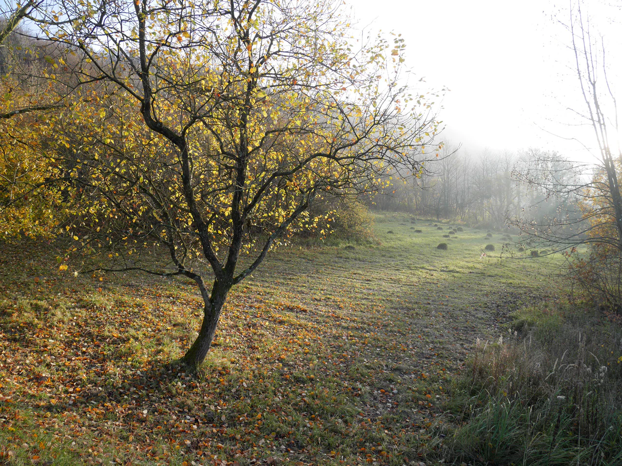
A meadow in autumn with a single tree in the foreground; several anthills dot the grass; dense trees line the background with soft sunlight.
A mown meadow with anthills visible within the Réserve naturelle régionale du Molinet during autumn.

Réserve naturelle régionale du Molinet ecosystems, habitats, and plant life

Ecologically, the Molinet reserve is best understood as a calcareous habitat complex. The woodlands are dominated by tree and shrub species adapted to lime-rich soils, while the pelouses calcicoles, or calcareous grasslands, host a specialized flora typical of this rare habitat type in northern France. The presence of moisture-tolerant species such as the marsh grass of Parnassus also indicates locally humid conditions alongside the drier calcareous slopes.

The juxtaposition of woodland, dry calcareous grassland, and small wet zones within just a few hectares creates a habitat mosaic of unusually high ecological density. Around 180 plant species have been recorded on the site, approximately 23 of which are considered to be of patrimonial interest, a notable ratio given the small area involved.

Réserve naturelle régionale du Molinet wildlife and species highlights

The fauna of the Molinet reserve reflects the diversity of its calcareous habitats. The hazel dormouse is among the notable mammal species recorded, reflecting the importance of well-structured woodland for this small mammal. The presence of the line-winged grasshopper, Stenobothrus lineatus, and the azuré bleu céleste butterfly highlights the value of the open calcareous grasslands for specialist invertebrates.

Although the reserve is too small to host large mammal populations, the combination of woodland edges, scrub, and open calcareous grassland supports a varied community of insects, small mammals, and breeding birds typical of these habitats. The mosaic structure is particularly favorable for species that depend on the transition between woodland and open calcareous ground.

Réserve naturelle régionale du Molinet conservation status and protection priorities

The Molinet reserve has clear conservation significance at the regional level. Although small in size, its role is disproportionate relative to its area because it conserves a calcareous habitat mosaic that has been heavily reduced elsewhere in the Boulonnais. Its designation under the regional nature reserve framework and its IUCN Category IV status reflect a management approach aimed at maintaining and restoring specific habitats and species rather than broader wilderness protection.

The reserve is managed by the Conservatoire d'espaces naturels du Nord et du Pas-de-Calais, which is responsible for maintaining the calcareous woodlands, the calcareous grasslands, and the associated flora. Its location within the Parc naturel régional des Caps et Marais d'Opale also helps connect it to wider regional conservation strategies. The drinking-water protection function associated with the site adds an additional layer of conservation relevance by linking habitat preservation to water resource protection.

Réserve naturelle régionale du Molinet cultural meaning and human context

The reserve's name is anchored in local heritage through its connection to the Château du Grand Molinet, an 18th-century estate that gives the site its identity in the surrounding landscape. This link between semi-natural habitat and a historic rural property illustrates how protected natural areas in the Boulonnais often emerge from landscapes shaped by long-standing aristocratic estates and their grounds.

The reserve also sits within a region, the Boulonnais, that carries strong local identity, marked by traditional relations between agricultural land, woodlands, springs, and small estates. While not a major cultural landmark, the Molinet reserve is part of this broader rural and cultural fabric of inland Pas-de-Calais.

Top sights and standout views in Réserve naturelle régionale du Molinet

A compact calcareous woodland and calcareous grassland reserve in the Pas-de-Calais, distinguished by an unusually rich flora for its small area. The site supports close to 180 plant species with about 23 of patrimonial interest, including the spatula-leaved ragwort, Müller's helleborine, and the marsh grass of Parnassus. Its management by the Conservatoire d'espaces naturels du Nord et du Pas-de-Calais and its location within the Parc naturel régional des Caps et Marais d'Opale give it strong institutional support and ecological connectivity.

Best time to visit Réserve naturelle régionale du Molinet

Because public access to the reserve is restricted and requires authorization, the best window for a meaningful visit is generally the late spring and early summer, when calcareous grasslands across the Boulonnais tend to display their richest flowering display. Autumn also offers a quieter, more atmospheric experience of the woodlands, as suggested by seasonal photographic records of the site. Any visit should be planned in coordination with the managing conservatory rather than treated as an open public site.
Monthly climate preview

Measured monthly temperature ranges and precipitation averages from NASA data records

Climate Normals and Temperature Rhythms for Réserve naturelle régionale du Molinet

Representative coordinate records show mean monthly temperatures ranging from 3.64 degrees Celsius to 17.11 degrees Celsius alongside daily precipitation rates between 1.65 mm and 3.03 mm. Exploring the complete twelve-month profile provides a detailed breakdown of long-term climate normals across the protected terrain.
Annual mean10 °C
4 °C17 °C
Jan
Feb
Mar
Apr
May12°
Jun15°
Jul17°
Aug17°
Sep15°
Oct11°
Nov
Dec
Warmest month
August

17.1 °C

Coolest month
January

3.6 °C

Wettest month
December

3 mm/day

Driest month
April

1.7 mm/day

Park location guide

Geography guide, regional context, and park location map for Réserve naturelle régionale du Molinet

Réserve naturelle régionale du Molinet park geography, regions, and map view in France

Understand where Réserve naturelle régionale du Molinet sits in France through a broader geographic reading of the surrounding landscape, nearby location context, and its mapped position within the national park landscape.

How Réserve naturelle régionale du Molinet fits into France

France is a unitary semi-presidential republic and one of the world's largest economies. It borders Belgium, Luxembourg, Germany, Switzerland, Italy, Monaco, Andorra, and Spain, with a maritime border to the United Kingdom. The country is known for its cultural influence, art, cuisine, and political history spanning centuries.

Wider geography shaping Réserve naturelle régionale du Molinet in France

France is located in Western Europe. Metropolitan France extends from the Rhine to the Atlantic Ocean and from the Mediterranean Sea to the English Channel and North Sea. The country borders Belgium, Luxembourg, Germany, Switzerland, Italy, Monaco, Andorra, Spain, and has a maritime border with the United Kingdom.

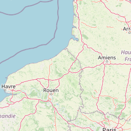
Map view of Réserve naturelle régionale du Molinet

Use this park location map to pinpoint Réserve naturelle régionale du Molinet in France, understand its exact geographic position, and read its mapped placement within the surrounding landscape more clearly.

Pigeon | © OpenStreetMap contributors

Location context for Réserve naturelle régionale du Molinet

Hauts-de-France
Recorded earthquake history

Browse the Historical Earthquake Catalogue for Réserve naturelle régionale du Molinet

Discover the documented history of seismic events associated with this protected area. MoriAtlas provides a clear, data-driven view of past regional earth movements to support geographic understanding of the landscape surrounding the reserve.

Réserve naturelle régionale du Molinet Earthquake Records

Catalogued events

6 events

Strongest magnitude

Magnitude 4

Most recent event

Jan 27, 1998

This history includes earthquakes recorded inside the park or within 50 km of its borders

Visualizing calcareous woodlands, open grasslands, and limestone terrain.

Réserve naturelle régionale du Molinet Landscape Photos and Scenery

Photographic documentation reveals the distinct topography and compact habitat mosaic defining Réserve naturelle régionale du Molinet. Visual records highlight rare flora ecosystems and limestone terrain across northern France.

A meadow filled with green grass and yellow Tephroseris helenitis wildflowers, with a backdrop of a lush green forest under a clear blue sky.

A large, leafless deciduous tree stands in a green field, with a forested hillside and a spoil tip visible in the background under a clear sky.

A meadow in autumn with a single tree in the foreground; several anthills dot the grass; dense trees line the background with soft sunlight.

Park atlas

Compare regional calcareous landscapes and neighboring Pas-de-Calais reserves

Explore Protected Areas and Parks Near Réserve Naturelle Régionale du Molinet

Browse adjacent protected areas and regional nature reserves surrounding Réserve naturelle régionale du Molinet. Compare limestone woodland habitats and regional park geography across northern France.
A soft watercolor illustration showing a low-lying landscape with gentle rolling hills, grassy foreground vegetation, and light, hazy atmospheric tones.
Nature reserveHauts-de-France
11 km away#1 closest

West

Réserve naturelle régionale du marais de Condette: Wetland Geography and Protected Landscape

A vital ecological corridor within the Hauts-de-France region

Spanning 35 hectares, the Réserve naturelle régionale du marais de Condette protects a unique mosaic of marshland, peat-forming habitats, and forested massifs. This wetland reserve near the Opal Coast acts as an essential green infrastructure link, providing critical sanctuary for flora and fauna while maintaining hydrological balance in a heavily transformed northern French landscape.

Area
0.35 km²
Established
2009
IUCN
IV
Relief
Lowland
Watercolor painting of a coastal landscape with sand dunes, beach grasses, and distant hills under a light sky.
Nature reservePas-de-Calais
14 km away#2 closest

Southwest

Réserve naturelle nationale de la baie de Canche Protected Area Map and Geography

Coastal dune ecosystems and tidal estuary landscapes in Pas-de-Calais

This protected area offers a look into the geomorphology of the Canche estuary, where longshore drift, salt marshes, and rare chalk-cliff dune systems create a distinct environment. Understand the landscape context of this French national nature reserve, serving as a sanctuary for migratory bird populations and a site for active coastal research along the English Channel.

Area
5.05 km²
Established
1987
IUCN
IV
Relief
Lowland
Nature reserveHauts-de-France
About 22 km away#3 closest

Northwest

Réserve naturelle régionale du pré communal d'Ambleteuse: Regional Nature Reserve Geography

Coastal dune relics and protected marshland in Hauts-de-France.

This protected area provides an essential look at the coastal geography of the Opal Coast. Featuring a complex mosaic of ancient dune turf, dry heath, and wet meadows, the reserve stands as a landmark for biodiversity and traditional land management in northern France.

Area
0.605 km²
Established
1991
IUCN
IV
Relief
Lowland
Nature reserveHauts-de-France
About 23 km away#4 closest

North

Réserve naturelle régionale de la forteresse de Mimoyecques: Regional Nature Reserve Geography

Protected subterranean habitat and wartime heritage in Hauts-de-France.

Located in the rolling lowlands of the Pas-de-Calais, the Réserve naturelle régionale de la forteresse de Mimoyecques is a uniquely managed protected area. Its landscape integrates historical military architecture with modern biodiversity conservation, focusing on the protection of rare underground roosting environments for diverse bat species within the regional Hauts-de-France terrain.

Area
0.016 km²
Established
2012
Relief
Lowland
Climate
Temperate
A horizontal watercolor painting showing a soft landscape with green vegetation, pink accents, and a winding body of water leading towards distant hills.
Nature reserveFrance
About 26 km away#5 closest

North

Réserve naturelle régionale du mont de Couple: Protected Chalk Escarpment and Coastal Viewpoint

A limestone ridge sanctuary in the northern French Boulonnais region

Spanning a rare chalk cuesta in northern France, this protected area balances ecological conservation with distinct geological features. The reserve provides critical habitat for orchids and protected flora while serving as a strategic viewpoint across the Straits of Dover and the surrounding Opal Coast terrain.

Area
0.136 km²
Established
1997
Relief
Upland
Climate
Temperate
A soft watercolor painting of a grassy landscape with exposed limestone rock faces and green vegetation.
Nature reserveHauts-de-France
About 26 km away#6 closest

East

Réserve naturelle régionale des anciennes carrières de Cléty: Protected Geological Landscape

Regional nature reserve in the Hauts-de-France, France

A significant geological protected area in the Pas-de-Calais, this reserve features an exposed chalk quarry face that serves as a stratigraphic record for the Cretaceous period. The landscape hosts a rare intersection of geological heritage and diverse ecosystems, including orchids, butterflies, and bat colonies, within a compact footprint.

Area
0.02 km²
Established
2011
IUCN
IV
Nature reserveHauts-de-France
30 km away#7 closest

Northeast

Réserve naturelle régionale de Pont d'Ardres: Mapped Wetland Geography and Protected Lands

A restored industrial landscape in the Hauts-de-France coastal hinterland.

Situated southeast of Calais, this reserve represents a rare success in ecological restoration. The former sugar factory basins now provide vital habitats for shorebirds and nesting species, maintaining an essential wetland presence in an otherwise cultivated landscape of northern France.

Area
0.663 km²
Established
2012
IUCN
IV
Relief
Lowland
Nature reserveHauts-de-France
32 km away#8 closest

East

Réserve naturelle régionale du plateau des landes: Regional Nature Reserve Landscape Profile

Protected heathland geography in the Pas-de-Calais corridor.

Understand the ecological structure of the Réserve naturelle régionale du plateau des landes. This protected area features a unique crescent shape and mosaic of heathland sectors spread across several communes, offering a focused study of low-elevation inland conservation management in the heart of northern France.

Area
1.811 km²
Established
2009
IUCN
IV

Common questions about visiting, size, designation, and location context for Réserve naturelle régionale du Molinet

Réserve naturelle régionale du Molinet FAQs for park facts, access, geography, and protected area context

Find quick answers about Réserve naturelle régionale du Molinet, including protected-area facts, park geography, trail and visitor context, and how the park fits into its surrounding country and regional landscape.
MoriAtlas Explorer

Continue Your Protected Areas Search Across the Global Atlas

Deepen your exploration by continuing the structured search for national parks and protected areas worldwide. Utilize the comprehensive filtering capabilities to compare different conservation landscapes and refine your understanding of global park geography. Discover more about the distribution and characteristics of protected natural areas.

Global natural geography