Why Santos Luzardo National Park stands out
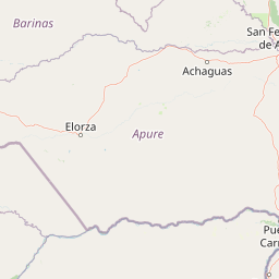
The park is best known for its representation of the Venezuelan llanos ecosystem, one of the most distinctive tropical savanna regions in South America. The expansive seasonal grasslands interspersed with gallery forests along riverbanks create a landscape of exceptional ecological character. The confluence area where the Capanaparo and Cinaruco rivers meet the Orinoco establishes a rich wetland environment that supports diverse habitats. The park protects significant portions of what is locally termed sabana vegetation, the characteristic grassland plains that define the llanos identity and represent one of Venezuela's most recognizable natural landscapes.
Santos Luzardo National Park history and protected-area timeline
Santos Luzardo National Park was established on February 24, 1988, through a presidential decree issued by President Jaime Lusinchi. The creation of the park represented an important step in Venezuela's efforts to conserve its representative llanos ecosystems, which had faced increasing pressure from agricultural expansion and cattle ranching throughout the 20th century. The park was named in honor of Santos Luzardo, a notable figure associated with the region, though the park also carries the alternative designation of Cinaruco-Capanaparo National Park reflecting its geographic positioning between these two major rivers. Management authority rests with INPARQUES, the National Institute of Parks of Venezuela, which implements conservation policies and oversees visitor management within the protected area.
Santos Luzardo National Park landscape and geographic character
The landscape of Santos Luzardo National Park exemplifies the classic Venezuelan llanos topography, featuring extensive flat to gently rolling plains that stretch to the horizon. The terrain is dominated by seasonal savanna vegetation that experiences dramatic flooding during the wet season, transforming the grasslands into a vast wetland ecosystem. The Capanaparo and Cinaruco rivers carve channels through the park, creating natural waterways that serve as the lifeblood of the regional ecosystem. These rivers, originating in the Andes and flowing north to join the Orinoco, bring sediment-rich waters that sustain the floodplain ecosystems. The landscape includes scattered palm groves, gallery forests along watercourses, and open grassland areas where the iconic sabana vegetation predominates. The interplay between the river systems and the seasonal flood cycle creates a dynamic environment that supports the specialized flora and fauna characteristic of the llanos.
Santos Luzardo National Park ecosystems, habitats, and plant life
The nature of Santos Luzardo National Park reflects the ecological character of the Venezuelan llanos, a biome of international significance for its unique combination of tropical savanna and wetland habitats. The vegetation patterns follow the hydrological cycle, with gallery forests dominating along permanent watercourses while the surrounding plains support grasses and herbaceous plants adapted to seasonal flooding and drought. The park's flora includes species adapted to the challenging environmental conditions, with characteristics that allow survival through wet and dry seasons. Gallery forests along the rivers provide critical habitat for numerous species, creating vertical structure and shade in an otherwise open landscape. The seasonal flood pulse that drives the llanos ecosystem creates productive conditions for aquatic and semi-aquatic species, supporting complex food webs throughout the protected area.
Santos Luzardo National Park wildlife and species highlights
While the Wikipedia source provides limited specific information about wildlife, the llanos ecosystem of Santos Luzardo National Park supports the characteristic fauna expected of this biome. The combination of seasonal wetlands, savanna grasslands, and gallery forests creates diverse habitats supporting both terrestrial and aquatic species. The river systems and floodplains provide critical habitat for fish, waterbirds, and wetland-dependent species, while the savanna areas support populations of large herbivores and their predators. Gallery forests serve as refuge and nesting areas for numerous bird species and provide corridors for mammals moving through the landscape.
Santos Luzardo National Park conservation status and protection priorities
Santos Luzardo National Park represents an important conservation asset for Venezuela, protecting representative examples of the llanos ecosystem that have been significantly altered by agricultural conversion elsewhere in the country. The IUCN Category II designation reflects the park's primary objective of preserving natural landscapes and associated biodiversity. The protected area safeguards the confluence zone of the Capanaparo and Cinaruco rivers with the Orinoco, an area of particular ecological significance within the larger Orinoco basin. INPARQUES maintains authority over the park's management, implementing conservation policies aimed at preserving the natural resources while allowing for sustainable use where appropriate. The park faces ongoing challenges common to protected areas in tropical regions, including the need to balance conservation objectives with the economic pressures that drive land-use change in surrounding areas.
Santos Luzardo National Park cultural meaning and human context
The park exists within a region shaped by the cultural traditions of the llanos, an area historically associated with cattle ranching and rural Venezuelan identity. The rivers that traverse the park have supported human settlement and traditional land-use practices for generations. The name Santos Luzardo reflects a local historical figure, connecting the protected area to regional heritage and identity. The llanos culture, characterized by its distinctive music, folklore, and equestrian traditions, remains intertwined with the landscape that the park protects.
Top sights and standout views in Santos Luzardo National Park
Santos Luzardo National Park protects one of the most extensive and intact examples of Venezuelan llanos landscape, featuring the dramatic seasonal transformation between flooded wetlands and dry-season savanna. The park's river confluence area creates exceptional wetland habitat where the Capanaparo and Cinaruco rivers join the Orinoco system. The gallery forests along the waterways provide striking contrast to the open grasslands, showcasing the ecological complexity of the llanos. The protected area represents a critical conservation enclave for a biome that has been substantially reduced by agricultural development across its historical range.
Best time to visit Santos Luzardo National Park
The llanos ecosystem experiences pronounced seasonal cycles that profoundly affect the character of a visit to Santos Luzardo National Park. The wet season, typically from May through November, transforms the savanna into an expansive wetland where wildlife concentrates around remaining water sources, creating excellent opportunities for observing aquatic birds and large mammals. The dry season, from December through April, draws water away from the floodplain, concentrating animals around remaining rivers and ponds, which facilitates wildlife viewing. Visitors interested in experiencing the full ecological pulse of the llanos should consider timing their visit to witness either the dramatic flooding or the distinctive dry-season landscape, depending on their interests.