
Mori Atlas logo
Natural monumentMonumento natural Piedra la Tortuga

Tracing the granite landscapes, ancient petroglyphs, and protected biodiversity of southern Venezuela

Monumento natural Piedra la Tortuga: A Geologic and Cultural Landmark in Amazonas, Venezuela

(Monumento Natural Piedra La Tortuga)

Monumento natural Piedra la Tortuga stands as a distinctive protected landscape in the Amazonas region of Venezuela, defined by massive Precambrian granite outcrops and significant archaeological sites. This natural monument encompasses a mosaic of tropical dry forest, llanos savanna, and riparian gallery forests, supporting high avian diversity and indigenous cultural history. The protected footprint offers a profound look at ancient geological formations and their role in the ecological and social geography of the Orinoco borderlands.

granite outcropsPrecambrian geologyrock artpetroglyphstropical dry forestsavanna
A graphic illustration featuring two large, rounded dark brown rock mountains rising above a foreground of light green tropical plants, palms, and shrubs, with a sunset sky in the background.

Monumento natural Piedra la Tortuga

Natural monument

Park overview

Structured park overview, official facts, and landscape profile for Monumento Natural Piedra La Tortuga

Monumento Natural Piedra La Tortuga park facts, protected area profile, and essential visitor context

Review the core facts for Monumento Natural Piedra La Tortuga, including designation, size, terrain, visitor scale, habitats, and operating context in one park-focused overview.

About Monumento Natural Piedra La Tortuga

The Monumento Natural Piedra La Tortuga protects a pair of prominent granite outcrops in the heart of Amazonas state, a region more commonly associated with rainforest than with exposed ancient rock. The outcrops belong to the Serranía del Parhuaza, a geological formation composed of acidic igneous rocks dating to the Precambrian, an era so distant that the formation is estimated to be around 1.5 billion years old. These isolated rocky massifs rise above surrounding savannas, dry forests, and river corridors, creating a landscape that feels both unexpected within the Amazonian context and ecologically distinctive.

Defined as a natural monument by decree number 2,351 on June 5, 1992, the protected area extends across roughly 1,950 hectares of the Atures municipality, not far from Puerto Ayacucho. Although modest in size, its significance is out of proportion to its area. The monument contains the largest petroglyph recorded in Venezuela, a finding that situates the site as a national reference point for indigenous rock art. It also preserves caves and burial sites of ancient populations, along with a remarkable diversity of rupestrian paintings, making it an exceptional archaeological and cultural reserve as well as a geological one.

Two indigenous communities, of the Hiwi (Guahibo) and Piaroa (Wothuha) ethnic groups, live within the protected area, giving the monument a living cultural dimension that complements its physical and archaeological heritage. The site's combination of billion-year-old rock, ancient human traces, and present-day indigenous presence gives Piedra La Tortuga a layered identity that goes well beyond the conventional idea of a natural monument.

Ecologically, the area is equally diverse. The surrounding vegetation includes tropical dry forest, graminoid savannas of llanos character, dense palm communities on the upper slopes and depressions, morichales, and gallery forests along the Cataniapo River and Caño Pintao. This habitat mosaic supports about 300 recorded bird species and a characteristic suite of lowland mammals and reptiles, reinforcing the monument's importance as a refuge within a broader landscape mosaic.

Quick facts and research context for Monumento Natural Piedra La Tortuga

Monumento Natural Piedra La Tortuga covers roughly 1,950 hectares in Atures municipality, Amazonas state, Venezuela, near Puerto Ayacucho. It was declared a natural monument by decree number 2,351 on June 5, 1992, and was later recognized as a Cultural Asset of Interest. The protected area encompasses two granite outcrops from the Serranía del Parhuaza, Precambrian igneous rocks around 1.5 billion years old, and contains caves, ancient burial grounds, rock art, and the largest petroglyph known in Venezuela. Vegetation ranges from tropical dry forest and graminoid savannas to rock-dwelling plant communities and morichales, while fauna includes about 300 recorded bird species and characteristic lowland mammals and reptiles.

Protection and recognition

Examine the verified terrestrial conservation scope and official recognition details.

Monumento natural Piedra la Tortuga Protection Status and Terrestrial Designation Records

Monumento natural Piedra la Tortuga maintains a documented terrestrial protection scope within the global conservation network. Review the verified designation metrics and administrative records associated with this protected landscape.

Protection details

Protection scope
Terrestrial
Transboundary protection
No
Park context

Deeper park guide and search-rich context for Monumento Natural Piedra La Tortuga

Monumento Natural Piedra La Tortuga history, landscape, wildlife, and travel context

Explore Monumento Natural Piedra La Tortuga through its history, landscape character, ecosystems, wildlife, conservation priorities, cultural context, and seasonal travel timing in a structured park guide built for atlas discovery and search intent.

Why Monumento Natural Piedra La Tortuga stands out

Piedra La Tortuga is best known for its dramatic Precambrian granite outcrops within the Serranía del Parhuaza and for hosting the largest petroglyph yet documented in Venezuela, alongside caves, ancient indigenous cemeteries, and an exceptional collection of rock paintings. Equally distinctive is the convergence of geology, archaeology, and living indigenous heritage, as two communities of Hiwi (Guahibo) and Piaroa (Wothuha) peoples reside within the protected area.
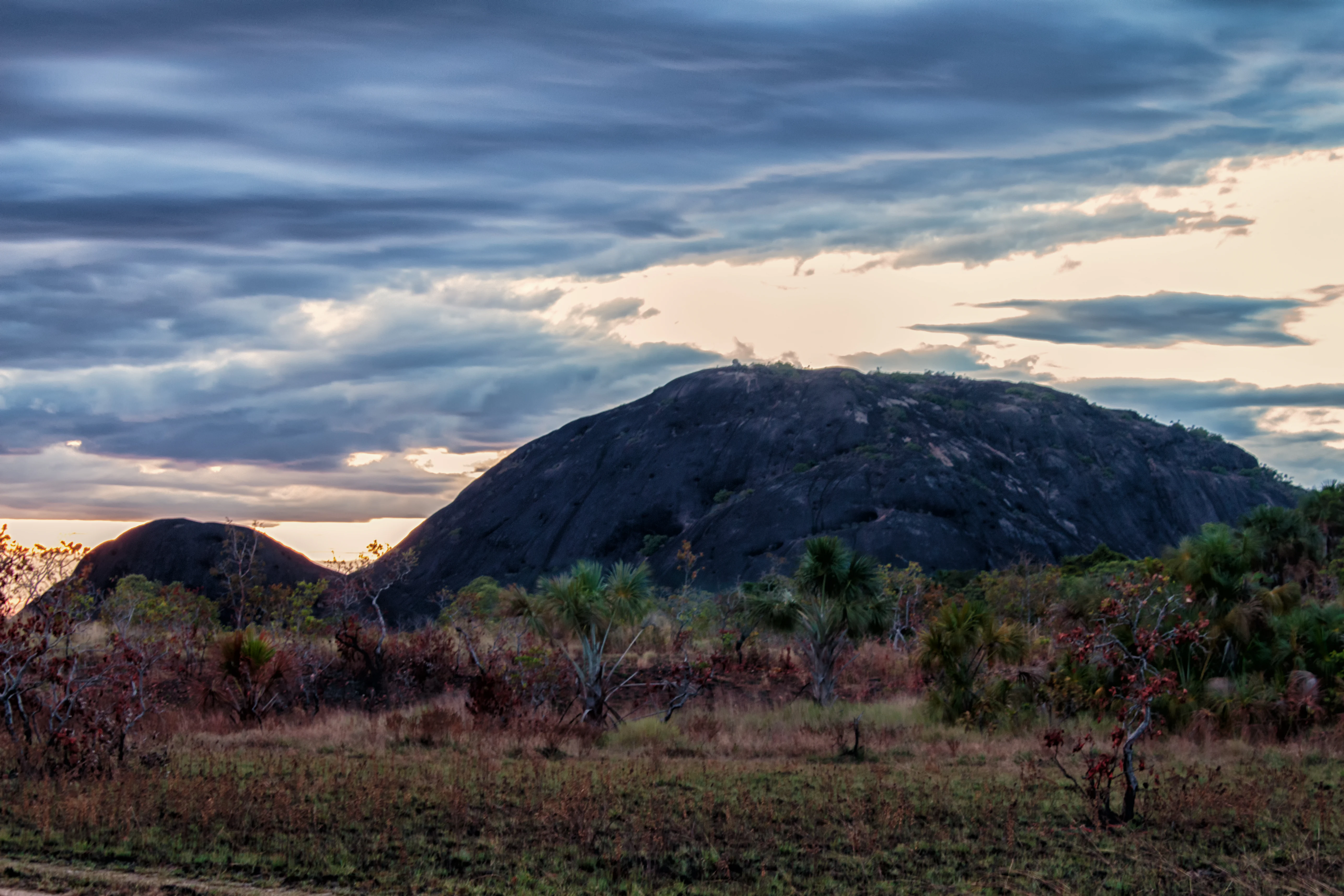
A large, dark, rounded granitic rock formation rises above a dry, shrub-covered landscape under a dramatic, cloudy sky at dusk.
The massive granitic outcrop of Piedra la Tortuga, a defining landmark in Amazonas, Venezuela.

Monumento Natural Piedra La Tortuga history and protected-area timeline

Piedra La Tortuga was officially designated as a natural monument by decree number 2,351, issued on June 5, 1992, and published in the official gazette number 35089 on November 11, 1992. The protection recognized both the geological singularity of the granite outcrops of the Serranía del Parhuaza and the cultural value of the petroglyphs, caves, ancient cemeteries, and rock art concentrated on and around the formation.

On July 22, 2005, the site was additionally declared a Bien de Interés Cultural (Cultural Asset of Interest), reflecting its standing not only as a natural landmark but as a heritage site of national relevance. This dual recognition underscored the importance of preserving the archaeological record and indigenous cultural presence alongside the natural environment.

Monumento Natural Piedra La Tortuga landscape and geographic character

The landscape of Piedra La Tortuga is defined by two large granite outcrops that rise abruptly from the surrounding lowlands, forming one of the most recognizable geological features of the southern Amazonas region. These outcrops belong to the Serranía del Parhuaza, a formation composed of acidic Precambrian igneous rocks roughly 1.5 billion years old, making the rock itself among the oldest exposed surfaces in Venezuela.

The elevations within the protected area range roughly between 100 and 400 meters above sea level, although the dramatic visual impression comes more from the contrast of exposed stone against flat savanna and riparian corridors than from sheer altitude. Around the rock, the terrain shifts into tropical dry forest and graminoid savannas of llanos character, while the Cataniapo River and Caño Pintao carve gallery forest lines through the broader plain. The result is a striking mosaic of rock, savanna, palm stands, and water, all compressed within a relatively compact protected footprint.

Monumento Natural Piedra La Tortuga ecosystems, habitats, and plant life

Plants and habitats at Piedra La Tortuga reflect the unusual combination of exposed ancient rock, dry lowland climate, and nearby watercourses. The vegetation associated with the lajas, or lithosolic outcrop surfaces, is dominated by pyrophilous species adapted to fire-prone conditions, and the broader landscape includes tropical dry forest and graminoid savannas typical of the llanos.

Common woody species in the drier formations include chaparro (Curatella americana), manteco (Bowdichia virgilioides), and alcornoque (Byrsonima crassifolia), along with chaparral and transitional scrub communities. A notable botanical highlight is the picatón (Platicarpium orinocense), considered endemic to the savannas of Amazonas state, and the pyrophytic cacho e' venao (Vellozia tubiflora), which grows directly on the rocky outcrops.

On the upper slopes and in depressions of the rock, dense vegetation develops, including stands of cucurito palm (Maximiliana regia) and coroba palms (Scheelea species). Along the riverbanks, morichales, riparian forests, and gallery forests create corridors of wetter habitat that contrast with the drier upland communities and significantly increase the ecological diversity of the site.

Monumento Natural Piedra La Tortuga wildlife and species highlights

The protected area supports around 300 recorded bird species, a remarkable figure given its relatively compact size, reflecting the diversity of habitats from rocky outcrops and savanna to gallery forest. Birdlife includes the striking gallito de las rocas (Rupicola rupicola), the semillero chirri (Oryzoborus crassirostris), the widespread roadside hawk known locally as gavilán habado (Buteo magnirostris), the oripopo (Cathartes melambrotus), the carpintero real (Dryocopus lineatus), and the gavilán pita venado (Heterospizias meridionalis).

Among mammals, the area hosts rabbits (Sylvilagus floridanus), the common nine-banded armadillo known locally as cachicamo (Dasypus novemcinctus), and the much larger giant armadillo (Priodontes maximus). Reptiles include the common lancehead mapanare (Bothrops atrox) and the boa constrictor, locally known as tragavenado. The combination of rocky terrain, savanna, and riverside forest allows a wide range of species to coexist within the monument.

Monumento Natural Piedra La Tortuga conservation status and protection priorities

The conservation significance of Piedra La Tortuga lies in the unusual convergence of geological, archaeological, ecological, and cultural values within a single protected area. The Precambrian granite of the Serranía del Parhuaza represents an irreplaceable geological record, while the petroglyphs, caves, rock art, and ancient burial sites preserved on the rock constitute a heritage asset of national importance, recognized through its Cultural Asset of Interest designation in addition to its natural monument status.

Ecologically, the site protects a distinctive mosaic of dry forest, savanna, rock outcrop vegetation, palm communities, and morichales, supporting a high bird diversity for its area and a characteristic lowland Amazonian fauna. The continued presence of indigenous Hiwi and Piaroa communities also gives the site long-term cultural value, linking the protection of nature with the protection of traditional ways of inhabiting the landscape.

Monumento Natural Piedra La Tortuga cultural meaning and human context

Piedra La Tortuga is inseparable from the indigenous heritage of the Atures region. Two indigenous communities, the Hiwi, also known as Guahibo, and the Piaroa or Wothuha, live within the protected area, maintaining a long-standing relationship with the land and the rock itself.

The site is also one of the most important rock art locations in Venezuela. It contains the largest known petroglyph in the country, along with caves, ancient cemeteries, and a rich body of rupestrian paintings, testifying to centuries of human presence on and around the outcrops. The site's dual recognition, both as a natural monument and as a Cultural Asset of Interest, reflects the way this indigenous and archaeological heritage is treated as inseparable from the natural value of the place.

Top sights and standout views in Monumento Natural Piedra La Tortuga

The defining features of Piedra La Tortuga are its billion-year-old granite outcrops, the largest petroglyph recorded in Venezuela, and an exceptional concentration of caves, burial sites, and rock art. The convergence of ancient geology, deep archaeological record, and continued indigenous presence in the Hiwi and Piaroa communities gives the site a uniquely layered identity. Ecologically, the mosaic of dry forest, savanna, rock outcrop vegetation, palm stands, and morichales along the Cataniapo River supports around 300 recorded bird species despite the area's modest size.

Best time to visit Monumento Natural Piedra La Tortuga

The tropical climate of Amazonas state means that Piedra La Tortuga can be visited throughout much of the year, but conditions vary with the dry and rainy seasons typical of the region. The drier period tends to offer clearer views of the rocky outcrops and easier access through the savanna and forest tracks, while the wetter months bring higher water levels along the Cataniapo River and Caño Pintao, fuller foliage, and more active wildlife observation, particularly for birds and river-associated species. Visitors interested in rock art and the exposed geology often favor drier windows, while those drawn to birdwatching and lush vegetation may appreciate the greener season.

Monthly climate preview

Long-term representative point measurements tracking annual temperature and precipitation rhythms

Monumento Natural Piedra La Tortuga Climate Normals And Weather By Month

Monumento natural Piedra la Tortuga records distinct long-term temperature ranges alongside marked monthly shifts in daily precipitation across the representative coordinate. Exploring the complete twelve-month climate profile reveals deeper baseline patterns and detailed variations in historical weather records.
Annual mean26 °C
25 °C29 °C
Jan26°
Feb28°
Mar29°
Apr27°
May26°
Jun25°
Jul25°
Aug25°
Sep25°
Oct26°
Nov26°
Dec26°
Warmest month
March

28.9 °C

Coolest month
July

24.7 °C

Wettest month
June

13.2 mm/day

Driest month
January

0.7 mm/day

Park location guide

Geography guide, regional context, and park location map for Monumento Natural Piedra La Tortuga

Monumento Natural Piedra La Tortuga park geography, regions, and map view in Venezuela

Understand where Monumento Natural Piedra La Tortuga sits in Venezuela through a broader geographic reading of the surrounding landscape, nearby location context, and its mapped position within the national park landscape.

How Monumento Natural Piedra La Tortuga fits into Venezuela

Venezuela is a country in northern South America with coastline along the Caribbean Sea and Atlantic Ocean. It borders Colombia, Brazil, Guyana, and Trinidad and Tobago. The country has an area of approximately 916,445 km² and a population of about 31.8 million. Caracas is the capital and largest city. Venezuela consists of 23 states and the Capital District.

Wider geography shaping Monumento Natural Piedra La Tortuga in Venezuela

Venezuela is located on the northern coast of South America. The continental territory is bordered by the Caribbean Sea and Atlantic Ocean to the north, Colombia to the west, Brazil to the south, and Guyana to the east. Trinidad and Tobago lies to the northeast. The country includes various islands and islets in the Caribbean Sea known as the Federal Dependencies.

Map view of Monumento Natural Piedra La Tortuga

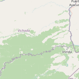
Use this park location map to pinpoint Monumento Natural Piedra La Tortuga in Venezuela, understand its exact geographic position, and read its mapped placement within the surrounding landscape more clearly.

Pigeon | © OpenStreetMap contributors

Location context for Monumento Natural Piedra La Tortuga

Amazonas

Visual exploration of granite outcrops, habitats, and protected terrain

Monumento natural Piedra la Tortuga Photos, Landscapes, and Scenery

Photographic records reveal the ancient granite monoliths, dry forests, and riparian habitats defining Monumento natural Piedra la Tortuga. Visual documentation offers direct insight into the geological formations and protected ecosystems characterizing the regional landscape.

A large, dark, rounded granitic rock formation rises above a dry, shrub-covered landscape under a dramatic, cloudy sky at dusk.

Two large, dark, rounded granitic rock formations stand above a flat, grassy savanna under a bright blue sky with scattered clouds.

Park atlas

Compare regional geography, ancient geological formations, and nearby natural monuments

Parks Near Monumento natural Piedra la Tortuga and Surrounding Protected Landscapes

Browse protected areas and natural monuments located close to Monumento natural Piedra la Tortuga in the southern Amazonas region. Comparing surrounding savanna ecosystems and geological formations provides broader context for regional conservation landscapes.
National parkVichada Department
33 km away#1 closest

Southwest

El Tuparro National Natural Park: Mapped Protected Landscape in Colombia's Vichada Department

Explore the geography and savanna terrain of this Orinoco basin national park.

El Tuparro National Natural Park stands as a significant protected area in the Vichada Department, embodying the ecological richness of Colombia's Llanos Orientales. Its landscape comprises extensive tropical savannas, striking gallery forests along major rivers like the Orinoco, and dramatic rapids. This page provides an atlas-focused view of El Tuparro National Natural Park, detailing its geographic boundaries and its importance as a conservation corridor within the region, crucial for understanding South American protected lands.

Area
5,480 km²
Established
1970
IUCN
II
Relief
Lowland
National parkApure State
About 126 km away#2 closest

North

Santos Luzardo National Park: Exploring Venezuela's Protected Landscape Geography

National park mapped boundaries and regional natural terrain.

This detailed entry for Santos Luzardo National Park focuses on its role as a national park and its contribution to the geographic atlas of Venezuela. It highlights the park's protected landscape, mapped terrain, and its specific setting within Apure State. Engage with concrete details that illuminate the park's protected status and its natural geographic features, perfect for atlas-driven exploration and understanding protected areas.

Area
5,844 km²
Established
1988
IUCN
II
Relief
Lowland
A watercolor painting of a wide landscape featuring a distant tepuy mountain, rolling green hills, and a river flowing through the foreground.
Natural monumentVenezuela
About 172 km away#3 closest

East

Monumento Natural Formaciones de Tepuyes: Protected Landscapes and Geological Map

Ancient tepuy table-top mountains in the Venezuelan Guayana Shield

Monumento Natural Formaciones de Tepuyes spans over one million hectares, safeguarding extraordinary geological formations defined by sheer vertical escarpments and flat-topped summits. As a vital protected area within the Guayana Shield, the site offers an essential view into isolated highland geography, endemic ecosystems, and the contrast between ancient mountain plateaus and tropical forest lowlands.

Area
10,698.2 km²
Established
1991
Relief
Mountain
Climate
Tropical
National parkAmazonas
181 km away#4 closest

Southeast

Yapacana National Park: Ancient Geology and Botanical Significance in Venezuela's Amazonas

Discover the dramatic plateau landscapes and unique flora of this protected national park.

Delve into the distinct geography and protected landscape identity of Yapacana National Park, a significant national park within Venezuela's Amazonas region. This page serves as a comprehensive atlas entry, detailing the park's core features, including its iconic Yapacana hill, a dramatic tepui formation representative of the ancient Guayana Shield. Understand the park's geological heritage and its exceptional botanical value, marked by unique floristic connections, all within the context of its Amazonian basin setting.

Area
3,200 km²
Established
1978
IUCN
II
Relief
Highland
National parkGuárico
268 km away#5 closest

North

Aguaro-Guariquito National Park: Protected Landscape and Geographic Mapping

Explore its Guárico regional setting and mapped park boundaries.

Aguaro-Guariquito National Park stands as a vital protected natural area within the Guárico region of Venezuela. This entry offers an atlas-centric view, focusing on the park's mapped boundaries and its role as a national park. Delve into its geographic identity and the context it provides for understanding protected landscapes in the area.

Area
5,857 km²
Established
1974
IUCN
II
Relief
Lowland
National parkAmazonas
273 km away#6 closest

Southeast

Parque nacional Duida-Marahuaca: Geographic Overview of Protected Tepui Landscapes in Venezuela

Mapping the highland ecosystems and river systems of Amazonas

Parque nacional Duida-Marahuaca protects a vast expanse of remote wilderness, anchored by the prominent Cerro Duida, Cerro Huachamacari, and Cerro Marahuaca. This site offers deep insights into the park's sandstone topography and hydrological connectivity within the broader Guayana Shield, providing a clear geographic understanding of these isolated table-top mesas and their surrounding forest habitats.

Area
2,100 km²
Established
1978
IUCN
II
Relief
Mountain
A soft watercolor painting showing a panoramic view of green grassy hills, scattered trees, and a calm water surface reflecting a pale dawn or sunset sky.
Wildlife reserveApure
About 280 km away#7 closest

Northwest

Hato El Cedral Wildlife Reserve and Apure Regional Wetland Landscape Geography

Mapping the seasonal plains and riverine corridors of the Venezuelan Llanos.

Hato El Cedral encompasses a vast mosaic of savanna, gallery forest, and seasonally flooded wetlands within the Apure state of Venezuela. This wildlife reserve functions as a critical sanctuary for biodiversity, characterized by its dramatic shifts between dry-season grasslands and wet-season lagoons. Our atlas view provides a detailed context for understanding the reserve's protected boundaries, its river-driven ecosystem, and its unique role in the geography of the Venezuelan Llanos.

Area
530 km²
Established
1987
Relief
Lowland
Climate
Tropical
A soft, horizontal watercolor painting of a wetland landscape with grassy areas and muted, rolling hills in the background.
Wildlife reserveApure
About 281 km away#8 closest

Northwest

Hato El Frío Wildlife Reserve: A Mapped Analysis of Apure's Protected Savanna Landscapes

Examining the ecological boundaries and seasonal wetlands of the Venezuelan llanos

Hato El Frío represents a rare convergence of traditional ranching culture and critical wildlife conservation. Spanning roughly 60,000 hectares, the reserve provides a structured look at the complex hydrological cycles of the Apure plains, where gallery forests and open lagoons support significant biodiversity. This overview offers insights into the regional geography, landscape transformation, and protected status of this enduring Venezuelan landmark.

Area
600 km²
Established
1989
Relief
Lowland
Climate
Tropical

Common questions about visiting, size, designation, and location context for Monumento Natural Piedra La Tortuga

Monumento Natural Piedra La Tortuga FAQs for park facts, access, geography, and protected area context

Find quick answers about Monumento Natural Piedra La Tortuga, including protected-area facts, park geography, trail and visitor context, and how the park fits into its surrounding country and regional landscape.
MoriAtlas Explorer

Continue Your Protected Areas Search Across the Global Atlas

Deepen your exploration by continuing the structured search for national parks and protected areas worldwide. Utilize the comprehensive filtering capabilities to compare different conservation landscapes and refine your understanding of global park geography. Discover more about the distribution and characteristics of protected natural areas.

Global natural geography