

Mori Atlas logo
National parkSimilajau National Park

Discover the mapped boundaries and regional geography of this important Malaysian national park.

Similajau National Park: Protected Landscape and Geographic Context in Bintulu Division

Similajau National Park stands as a significant protected natural area within Malaysia's Bintulu Division. As a national park, it offers a crucial point of study for understanding regional landscapes and mapped protected territories. This page provides detailed geographic context, helping users explore the park's identity as a distinct natural landscape and its place within the broader atlas of protected lands.

Coastal National ParkTropical RainforestBorneo WildlifeHornbill HabitatSea Turtle NestingDolphin Watching

Similajau National Park

National park

Park overview

Structured park overview, official facts, and landscape profile for Similajau National Park

Similajau National Park park facts, protected area profile, and essential visitor context
Review the core facts for Similajau National Park, including designation, size, terrain, visitor scale, habitats, and operating context in one park-focused overview.

About Similajau National Park

Similajau National Park represents an important coastal conservation area in northeastern Sarawak, protecting a stretch of shoreline and adjacent lowland forests that face increasing development pressure. The park's location along the South China Sea provides it with both marine and terrestrial ecological significance. Originally established in 1976 with an area of 70.64 square kilometers, the park was expanded in February 2000 with the addition of 19.32 square kilometers, bringing the total protected area to 89.96 square kilometers. This narrow coastal protected area extends approximately 30 kilometers from Sungai Likau in the south to Sungai Similajau in the north. The park is administered under Sarawak Forestry regulations and serves as both a conservation area and an educational destination for visitors interested in tropical rainforest ecosystems. The proximity to Bintulu makes Similajau one of the more accessible national parks in Sarawak for day trips and short camping excursions, while still maintaining a genuine wilderness character in its interior areas.

Quick facts and research context for Similajau National Park

Similajau National Park covers 89.96 square kilometers along the South China Sea coast in Bintulu Division, Sarawak, Malaysia. The park was established in 1976 and received a significant expansion in 2000, adding nearly 20 square kilometers to its original footprint. It is classified as IUCN Category II for national park protection. The park features three primary forest types: beach vegetation, kerangas heath forests, and mixed dipterocarp forest. Wildlife includes 24 mammal species, 185 bird species, and notable marine visitors such as dolphins and green sea turtles. The park maintains several marked nature trails including a 9.8-kilometer main trail leading to Golden Beach.

Park context

Deeper park guide and search-rich context for Similajau National Park

Similajau National Park history, landscape, wildlife, and travel context
Explore Similajau National Park through its history, landscape character, ecosystems, wildlife, conservation priorities, cultural context, and seasonal travel timing in a structured park guide built for atlas discovery and search intent.

Why Similajau National Park stands out

Similajau National Park is particularly known for its exceptional hornbill diversity, with eight species recorded including the rhinoceros hornbill and black hornbill. The park also hosts seasonal green sea turtle nesting at Turtle Beach from March to September, and dolphin populations are regularly observed in the coastal waters between March and September. The park contains a higher concentration of tongkat ali trees than any other national park in Sarawak, making it botanically distinctive. Its combination of accessible coastal rainforest, wildlife viewing opportunities, and relatively compact trail system makes it a notable destination within Sarawak's protected area network.

Similajau National Park history and protected-area timeline

Similajau National Park was first established in 1976 as a protected coastal area in Bintulu Division. The initial park boundary encompassed approximately 70.64 square kilometers, extending from the Sungai Likau area in the south to the Sungai Similajau in the north along a 30-kilometer coastal stretch. On February 17, 2000, a significant expansion added 19.32 square kilometers to the park, increasing its total area to 89.96 square kilometers. This expansion reflected the growing recognition of the park's ecological value and the need to protect additional coastal and forest habitat. The park operates under the management authority of Sarawak Forestry and maintains an official website for visitor information. The park has historically been referred to as both Similajau and Samalaju National Park, with the latter name appearing in some official and published sources.

Similajau National Park landscape and geographic character

Similajau National Park occupies a distinctive coastal position along the South China Sea, where the landscape transitions from sandy beaches and rocky shores through mangrove zones into lowland rainforest. The park's terrain is relatively flat near the coast but rises gently into rolling hills inland, supporting the mixed dipterocarp and kerangas forest types. Rocky outcrops such as Batu Anchau and Batu Mandi punctuate the landscape, with the latter visible only during low tide approximately four kilometers offshore. The park contains several watercourse features including the Likau River, which supports crocodilian populations, and the Sebubong River with its natural swimming pool accessible by boat. The coastline features distinct beach areas including Golden Beach and Turtle Beach, where seasonal turtle nesting occurs. The Selunsur Rapids provide another notable water feature, most visible after heavy rainfall.

Similajau National Park ecosystems, habitats, and plant life

The vegetation of Similajau National Park comprises three principal forest types that reflect the park's ecological diversity. Beach vegetation dominates the immediate coastal fringe, while kerangas heath forests characterize the more nutrient-poor soils of the park's interior. Mixed dipterocarp forest, typical of lowland Borneo, occupies the remaining areas and contains the park's tallest trees. The park is botanically notable for its population of tongkat ali, a slender tree reaching heights of up to 15 meters that produces clusters of red fruits maturing to black. This species occurs more abundantly in Similajau than in any other Sarawak national park. The bintangor tree is another significant species found in both hill and swamp forest areas within the park. The park supports mangrove forest along certain sections, particularly along the education trail where a 450-meter plank walk provides visitor access through this specialized coastal ecosystem.

Similajau National Park wildlife and species highlights

Similajau National Park supports a diverse fauna population across its terrestrial and marine environments. Twenty-four mammal species have been recorded within the park, including several primate species such as gibbons, Raffles' banded langurs, and long-tailed macaques. The bird population is particularly significant, with 185 species identified including eight hornbill species representing all major hornbill types found in Sarawak, including the prominent rhinoceros hornbill and black hornbill. Migratory water birds including Storm's stork pass through the park seasonally. Marine wildlife is abundant in the adjacent waters, with five dolphin species regularly observed: Irrawaddy dolphin, bottlenose dolphin, Indo-Pacific humpback dolphin, finless porpoise, and pantropical spotted dolphin. These dolphins can be seen from the park shore in groups of four or more during the early morning from March through September. Green sea turtles come ashore to nest at Turtle Beach during the same March to September period. The Likau River is home to both false gharial and saltwater crocodile species. The horseshoe crab appears along the shores during the breeding season from early May to October, often in pairs, with Sagor catfishes feeding on their eggs.

Similajau National Park conservation status and protection priorities

Similajau National Park functions as an important protected area within Sarawak's coastal zone, preserving lowland forest ecosystems that have faced significant conversion pressure across Malaysian Borneo. The park's designation as IUCN Category II reflects its primary purpose of protecting natural ecosystems while allowing for compatible recreational use. The protection of the coastal strip, including beach, mangrove, and forest habitats, ensures continuity of habitat for species that depend on both terrestrial and marine environments. The dolphin populations represent a particular conservation concern, as these marine mammals require healthy ocean conditions and are sensitive to coastal development and maritime traffic. The seasonal turtle nesting beaches receive protection during the breeding season, helping to maintain nesting success for green sea turtles. The presence of eight hornbill species indicates the park provides suitable foraging and nesting habitat for these ecologically important birds, which serve as seed dispersers in tropical forests.

Similajau National Park cultural meaning and human context

Similajau National Park exists within the broader context of Sarawak's coastal communities and indigenous land-use traditions. The park area falls within the Bintulu Division, a region with a mix of Malay coastal communities and indigenous Bornean peoples. The river systems flowing through the park, including Sungai Likau and Sungai Similajau, have historically supported local fishing and transportation activities. The park's name derives from the Similajau River, which forms its northern boundary. While the park itself is managed as a protected area under state forestry authority, surrounding lands may continue to be used for traditional activities by local communities. The park provides educational opportunities through its nature trails, with the education trail specifically designed to teach visitors about local tree species, supporting environmental awareness and cultural understanding of the region's natural heritage.

Top sights and standout views in Similajau National Park

Similajau National Park offers several standout features that distinguish it within Sarawak's protected area network. The Golden Beach provides a scenic coastal destination accessible by hiking or boat along the 9.8-kilometer main trail. Turtle Beach I and II host seasonal green sea turtle nesting from March to September, offering wildlife observation opportunities during this period. The dolphin populations are reliably observable from the shore during the first half of the year, with groups regularly seen from the park in early morning hours. The eight hornbill species present make the park exceptional for birdwatching enthusiasts. The Batu Anchau black rock formation at the end of a 2.1-kilometer trail provides a distinctive geological landmark. The Sebubong Pool offers a natural swimming area in the river, accessible only by boat. The variety of trail options, ranging from the mangrove education trail to longer hikes to the beach and rock formations, provides diverse visitor experiences.

Best time to visit Similajau National Park

The optimal time to visit Similajau National Park depends on the experiences sought. For dolphin watching, the period from March to September offers the best odds of observing these marine mammals, with early morning visits providing the highest likelihood of sightings. Green sea turtle nesting at Turtle Beach occurs during the same March to September window, making this the ideal period for turtle-related wildlife observation. The dry season from early May to October brings horseshoe crabs to the shore for breeding, creating a unique opportunity to observe this ancient species. The monsoon season from November to March brings heavier rainfall to the region, which can affect trail conditions and accessibility. However, the Selunsur Rapids are most impressive after rainfall, so those interested in this feature may prefer the wetter months. Overall, the March to September period represents the most wildlife-rich season for the park.

Park location guide

Geography guide, regional context, and park location map for Similajau National Park

Similajau National Park park geography, regions, and map view in Malaysia
Understand where Similajau National Park sits in Malaysia through a broader geographic reading of the surrounding landscape, nearby location context, and its mapped position within the national park landscape.

How Similajau National Park fits into Malaysia

Malaysia is a federal constitutional monarchy located in Southeast Asia. The country consists of 13 states and three federal territories, divided by the South China Sea into Peninsular Malaysia on the Indochinese Peninsula and East Malaysia on the island of Borneo. With a population of over 34 million, it achieved independence from Britain in 1957 and became a modern federation in 1963. The country is recognized for its multicultural population, tropical climate, and significant economic role in the region.

Wider geography shaping Similajau National Park in Malaysia

Malaysia occupies a strategic position in Southeast Asia, split by the South China Sea into two distinct regions. Peninsular Malaysia lies on the Indochinese Peninsula, sharing a land border with Thailand to the north and maritime borders with Singapore, Vietnam, and Indonesia. East Malaysia occupies the northern portion of Borneo, sharing land borders with Brunei and Indonesia, and maritime borders with the Philippines and Vietnam. The country's terrain includes coastal plains, mountain ranges such as the Titiwangsa in the peninsula, and extensive tropical rainforests.

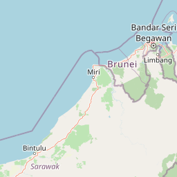
Map view of Similajau National Park

Use this park location map to pinpoint Similajau National Park in Malaysia, understand its exact geographic position, and read its mapped placement within the surrounding landscape more clearly.

Pigeon | © OpenStreetMap contributors

Location context for Similajau National Park

Bintulu DivisionSarawak
Park atlas

Explore the broader regional geography of protected landscapes and compare adjacent coastal rainforests of Malaysian Borneo.

Discover Other National Parks and Protected Areas Near Similajau National Park
After exploring Similajau National Park, compare other national parks and protected areas across Sarawak's diverse coastal and lowland rainforest geography. Browse mapped park locations and features to understand the regional spread of conservation landscapes and unique tropical ecosystems throughout Malaysian Borneo.
National parkBintulu Division

Bukit Tiban National Park: National Park Protected Area with Mapped Boundaries

Discover its geographic setting within Bintulu Division.

Bukit Tiban National Park stands as a significant protected natural area, offering a deep dive into its specific geography and mapped landscape. As a national park within Bintulu Division, it provides crucial atlas-level insight into regional protected lands. Explore the precise location and understand its context within Malaysia's network of natural conservation areas.

Area
96 km²
Established
2000
IUCN
II
Relief
Upland
Watercolor illustration of a landscape with green hills, trees, and a valley
National parkSarawak

Niah National Park: Sarawak's Protected National Park Geography and Mapped Landscape

Explore protected area boundaries and regional context within Sarawak

Niah National Park represents a significant protected national park, offering a distinct geographic and landscape identity within Sarawak, Malaysia. This resource facilitates the exploration of its mapped boundaries and its place within the regional atlas of Borneo. Users can delve into the specific geography of this protected area, understanding its landscape characteristics and its contribution to the broader conservation mapping of the region.

Established
1974
Relief
Mountain
Access
Moderate access
Scope
Terrestrial
National parkSarawak

Loagan Bunut National Park: Protected Landscape in Sarawak, Malaysia

Explore the mapped geography and natural terrain of this national park.

This page offers a detailed atlas-style exploration of Loagan Bunut National Park, situated in Sarawak, Malaysia. Understand the park's designation as a national park and its place within the mapped geography of Borneo. It provides essential context for appreciating the protected landscape and its regional significance.

Area
100 km²
Established
1990
IUCN
II
Scope
Terrestrial
National parkSarawak

Lambir Hills National Park: Sarawak's National Park Landscape and Geographic Discovery

Explore the mapped terrain and protected boundaries within Sarawak.

Investigate Lambir Hills National Park, a protected national park in Sarawak, Malaysia. This page provides essential geographic context and details its protected landscape identity. Understand its role within the Borneo region's atlas, offering users a deep dive into its mapped terrain and specific regional geography. Discover a key piece of Malaysia's natural protected areas with focused atlas-style information.

Area
69.52 km²
Established
1975
IUCN
II
Relief
Lowland
National parkMiri Division

Usun Apau National Park: National Park with Regional Geographic Context in Miri Division

Explore protected boundaries and mapped landscape details.

Usun Apau National Park represents a distinct protected landscape within the Miri Division, identified as a national park. This entry focuses on its geographic attributes, including its mapped boundaries and its contribution to the regional protected area network. Users can explore Usun Apau National Park to understand its specific role in the geography of Miri Division and to gain context on Malaysia's conservation landscapes.

Area
471.22 km²
Established
2005
IUCN
II
Relief
Mountain
Nature reserveBrunei

Luagan Lalak Forest Recreation Park Nature Reserve: Brunei's Pristine Freshwater Swamp Landscape

Explore mapped protected-area geography and unique wetland terrain.

Luagan Lalak Forest Recreation Park, a protected nature reserve in Brunei, preserves a rare and visually distinctive freshwater swamp ecosystem. Characterized by dark, tranquil waters and vast fields of purun grass, this natural wetland offers a unique landscape context and is a prime location for observing its rich biodiversity, especially its notable birdlife. The park's preservation as an intact swamp environment within a recreational area highlights its ecological importance for regional geography and protected-area mapping.

Area
2.7 km²
Established
1980
IUCN
II
Visitors
4.2K annual
National parkMarudi District

Gunung Mulu National Park: A Protected National Park with Distinct Geographic Identity in Marudi District

Explore its mapped protected area and regional landscape.

Gunung Mulu National Park stands as a key protected area within Marudi District, Malaysia, offering critical insights into the region's natural geography. This national park entity provides a focal point for understanding mapped protected landscapes and their specific geographic characteristics. Users can explore the park's boundaries and its role within the wider atlas of Malaysian natural areas, gaining a solid foundation in its conservation geography.

Area
528.64 km²
Established
1974
IUCN
II
Relief
Mountain
Protected areaBrunei

Tasek Merimbun Heritage Park: Protected Landscape Identity and Geographic Atlas

Mapped boundaries and regional natural context for this Brunei protected area.

Tasek Merimbun Heritage Park represents a distinct protected area within the geography of Brunei. This page provides detailed insight into its protected landscape, offering a map-centric view of its boundaries and its placement within the broader natural context of Borneo. Understand the park's geographic significance and explore its unique attributes for structured atlas exploration.

Area
78 km²
Established
1984
Climate
Tropical
Access
Easy access

Common questions about visiting, size, designation, and location context for Similajau National Park

Similajau National Park FAQs for park facts, access, geography, and protected area context
Find quick answers about Similajau National Park, including protected-area facts, park geography, trail and visitor context, and how the park fits into its surrounding country and regional landscape.
MoriAtlas Explorer

Continue Your Protected Areas Search Across the Global Atlas

Deepen your exploration by continuing the structured search for national parks and protected areas worldwide. Utilize the comprehensive filtering capabilities to compare different conservation landscapes and refine your understanding of global park geography. Discover more about the distribution and characteristics of protected natural areas.

Global natural geography
