Mori Atlas logo
National parkSounio National Park

Mapping the dramatic limestone cliffs, historic archaeological sites, and Aegean maritime scenery

Sounio National Park: A Protected Coastal Landscape on the Attica Peninsula of Greece

(Ethnikós Drymós tou Souníou)

Sounio National Park preserves the rugged southernmost promontory of the Attica peninsula, where vertical limestone cliffs drop into the Aegean Sea. Established to protect a mosaic of Mediterranean scrub, coastal coves, and significant classical monuments, this protected area serves as an essential maritime buffer along the historic southern edge of the Athens Riviera. Visitors can trace the geographic boundaries of this rocky landscape, observing how its thin, arid soils and exposed maritime habitat integrate ancient cultural history with the stark geography of the Greek coastline.

coastal parkarchaeological landscapeclassical antiquityAegean coastAtticaMediterranean scrub

Sounio National Park

National park

Park overview

Structured park overview, official facts, and landscape profile for Sounio National Park

Sounio National Park park facts, protected area profile, and essential visitor context

Review the core facts for Sounio National Park, including designation, size, terrain, visitor scale, habitats, and operating context in one park-focused overview.

About Sounio National Park

Sounio National Park is a small but culturally and ecologically distinctive protected area on the southern tip of the Attica peninsula. It wraps around Cape Sounion, the rocky promontory that forms the southeastern anchor of the Athens Riviera and marks the traditional boundary of the ancient region of Attica. The park preserves not only a stretch of arid coastal landscape but also one of the most emotionally powerful classical sites in Greece, where the surviving columns of the Temple of Poseidon overlook the Aegean Sea from a headland cut nearly vertical by geological uplift.

The terrain of the park centers on a limestone and marble promontory that rises to about sixty meters above sea level at the position of the temple. From this headland, the land falls in steep cliffs toward small coves and beaches on the western and northern sides, including a sheltered western bay historically used as a landing point. Inland, the protected area extends across a band of low Mediterranean vegetation, typical of southern Attica, where phrygana scrub, low shrubs, and drought-adapted plants cover the thin soils between rock outcrops. Because the park lies at the meeting point between the Attic mainland and the open sea, it acts as a coastal ecological transition zone, linking inland agricultural and forested landscapes of the Laurion peninsula with the marine environment of the Aegean.

Culturally, the park's identity is inseparable from the Sanctuary of Poseidon at Cape Sounion. The current temple, built in marble quarried locally at Agrileza north of the cape, was constructed during the height of the Athenian Empire and reflects the same architectural ambitions as the Parthenon and the Temple of Hephaestus on the Acropolis. Below and around it lie the remains of an earlier archaic sanctuary, the foundations of the Temple of Athena Souniados, the traces of a substantial Hellenic fortification, and a network of ancient roads and quarries that all fall within the modern protected area. The combination of dramatic coastline, classical archaeology, and accessibility from Athens has made Sounio one of the most visited national parks in Greece, while the formal designation in 1974 formalized the area as a place where cultural heritage and natural landscape are protected together.

Quick facts and research context for Sounio National Park

Sounio National Park is located at the southern tip of the Attica peninsula, within the Lavreotiki municipality and the East Attica regional unit of Greece. It protects the headland of Cape Sounion, roughly 69 kilometers southeast of central Athens, and the broader surrounding coastal landscape.

The park was established in 1974 to safeguard the environmental value of the area around the ancient sanctuary of Poseidon. It covers a core zone of about 750 hectares, centered on the rocky promontory that hosts the remains of the 5th-century BC Temple of Poseidon and the adjacent Temple of Athena, and extends through cliffs, coastal scrub, and small bays along the Athens Riviera.

Protection and recognition

Examine the documented terrestrial protection scope and official recognition framework.

Sounio National Park Protection Status and Conservation Recognition

Sounio National Park maintains a documented terrestrial protection scope and management framework within regional conservation boundaries. Official designation records detail the operational status and administrative context established for the protected area.

Protection details

Protection scope
Terrestrial
Transboundary protection
No
Core area
0.75 km²
Buffer area
2.75 km²
Park context

Deeper park guide and search-rich context for Sounio National Park

Sounio National Park history, landscape, wildlife, and travel context

Explore Sounio National Park through its history, landscape character, ecosystems, wildlife, conservation priorities, cultural context, and seasonal travel timing in a structured park guide built for atlas discovery and search intent.

Why Sounio National Park stands out

Sounio National Park is best known for the dramatic setting of the Temple of Poseidon, whose surviving Doric columns stand silhouetted against the Aegean Sea at the cape. The temple, built between 444 and 440 BC during the era of Pericles, has become one of the most photographed classical monuments in Greece, especially at sunset. The park is also recognized for its coastal cliff scenery and the legacy of the ancient deme of Sounion, which controlled access to the silver mining region of Laurion. The fortress walls around the headland, the buried archaic votive statues known as the Sounion Kouroi, and the nearby Temple of Athena Souniados together make the park a layered archaeological and ecological landscape rather than a single monument site.

Sounio National Park history and protected-area timeline

The history of Sounio National Park stretches back more than two and a half millennia. The headland first appears in Greek literary tradition in Homer's Odyssey, where the cape is described as holy and is associated with the burial of Phrontis, the helmsman of Menelaus, at the end of the return from Troy. By the 6th century BC, the Athenians were celebrating a quadrennial festival at Sounion, and the cape had become an important sacred site tied to the maritime power and wealth of Athens.

During the Archaic period, the Sanctuary of Poseidon was developed at the promontory with colossal votive statues known today as the Sounion Kouroi, three of which survive in the National Archaeological Museum of Athens. A tufa temple of Poseidon stood on the cape before being destroyed by the Persians under Xerxes in 480 BC. After the Greek victory at the Battle of Salamis, the Athenians dedicated an entire captured trireme at Sounion in thanksgiving to the god. In 444 to 440 BC, during the ascendancy of Pericles, the present marble temple of Poseidon was erected on the ruins of the earlier one, using white marble quarried at Agrileza a few kilometers to the north.

The cape was not only religious but also strategic. In the nineteenth year of the Peloponnesian War in 413 BC, the Athenians fortified Sounion with substantial walls and towers to protect the sea route carrying grain from Euboea to Athens after Spartan forces had cut overland supply lines. The fortress later passed through Macedonian, Ptolemaic, and rebel control, including an episode in which a thousand insurgent slaves from the Laurion silver mines seized it in the late 2nd century BC. In the Roman era, the site had already declined, though its fame endured. From the 17th century onward, European travelers and antiquarians, including the Scottish poet William Falconer, the English poet Lord Byron, and the philosopher Martin Heidegger in the 20th century, visited the cape and reinforced its romantic appeal.

The modern legal framework of the area changed in 1974, when Greece established the Sounio National Park around the cape, creating a protection regime that recognized both the archaeological importance and the surrounding Mediterranean coastal landscape. A subsequent EU and Greek Ministry of Culture project between 2011 and 2013, known as the Arrangement of the Archaeological Site of Sounion, improved site interpretation and access while reinforcing the link between environmental and cultural protection at the cape.

Sounio National Park landscape and geographic character

The landscape of Sounio National Park is defined by its position at the southeastern extremity of the Attica peninsula, where the land drops abruptly into the Aegean Sea. The central feature is the cape itself, a rocky promontory with near-vertical cliffs on three sides, where the surviving terrace of the Temple of Poseidon occupies the highest usable ground. The terrain is dominated by pale marble and limestone, the same materials that were quarried locally for the classical temples, and the underlying geology produces bright, reflective rock faces especially visible at sunset.

Below the headland, the coastline divides into a series of small embayments. On the western side, a protected cove historically served as a landing beach, while the eastern bay is more exposed. Inland from the cape, the protected area extends across a band of low coastal hills with thin, dry soils. Vegetation is characteristically Mediterranean, covering the slopes in a mosaic of scrub, low shrubs, and sparse trees, with frequent rocky outcrops breaking the surface.

The park sits within the broader landscape of the Athens Riviera. To the northwest, the coast continues toward residential and resort development, while the park itself preserves the more rugged southern end of this coastal corridor. To the northeast lies the historic mining landscape of Laurion, with ancient silver workings and the town of Lavrio, and offshore the small island of Patroklos closes the view west along the horizon from the temple terrace.

Sounio National Park ecosystems, habitats, and plant life

The natural environment of Sounio National Park is shaped by its exposed southern coastal setting. Soils are thin and dry, rainfall is limited, and summer temperatures are high, producing a classic Mediterranean semi-arid character. The result is a landscape dominated by drought-tolerant vegetation, including phrygana and maquis-type shrub communities, low aromatic plants, and scattered hardy trees, with bare rock dominating the most exposed cliff sections.

The park's coastline supports small but ecologically valuable marine-influenced habitats. Rocky shores, tidal pools, and shallow coves along the cape provide habitat for coastal invertebrates, fish, and seabirds, while the cliffs and headland are used as perches and nesting areas by raptors and other birds. The vegetation mosaic between the cape and inland slopes also provides refuge for typical Attic species such as reptiles, small mammals, and seasonal migratory and resident birds moving along the Attica coastline.

Sounio National Park wildlife and species highlights

Wildlife within Sounio National Park reflects the wider character of southern Attica's coastal habitats rather than the larger fauna of forested Greek parks. Birdlife is among the most visible elements, with the headland used by seabirds along the Aegean coast and by raptors and passerines hunting across the scrub-covered slopes. The mixture of cliff, scrub, and shoreline creates concentrated feeding and roosting zones in a relatively small area.

On land, the park supports the typical reptile and small mammal fauna of the region, including lizards and snakes adapted to rocky Mediterranean environments, as well as insect and pollinator communities associated with the aromatic flowering shrubs that bloom in spring. In the marine zone around the cape, shallow waters and rocky substrates host fish, octopus, and other invertebrates typical of the Aegean coast, though the park's protected status is primarily terrestrial.

Sounio National Park conservation status and protection priorities

The conservation significance of Sounio National Park lies in the combination of a formally protected coastal landscape with a heavily visited archaeological site. The 1974 designation established a legal framework to manage land use around the cape, limit development pressures from the growing Athens Riviera, and protect the Mediterranean coastal habitats of the southern Attica peninsula. The park's small core area reflects its status as a focused, site-centered national park rather than a wilderness reserve.

The park also plays an important role in integrating cultural heritage protection with natural landscape conservation. Recent EU-funded projects, including the 2011 to 2013 Arrangement of the Archaeological Site of Sounion, restructured visitor access to reduce impact on both the monuments and the surrounding vegetation. The result is a protected area whose conservation value rests as much on preserving views, setting, and the vegetation around the cape as on safeguarding the archaeological remains themselves.

Sounio National Park cultural meaning and human context

Cape Sounion carries an unusually deep cultural layer for a national park of its size. The site is one of the best-documented sacred capes of the ancient Greek world, where worship of Poseidon and Athena was tied to the maritime identity of Athens and to the silver wealth of Laurion. The ancient deme of Sounion was politically significant within the Athenian system, contributing members to the Boule and serving as a fortified guardian of the grain route to Athens during the Peloponnesian War.

In the modern era, the cape became a romantic landmark of European travel. Foreign visitors from the 17th and 18th centuries recorded the standing columns of the Temple of Poseidon, Lord Byron reportedly carved his name into one column during a stay in 1810 to 1811, and Martin Heidegger wrote philosophically about the ruins in the 1960s. Today, Sounio stands at the intersection of ancient sanctuary, classical archaeology, modern Greek cultural identity, and contemporary tourism along the Athens Riviera.

Top sights and standout views in Sounio National Park

Standout elements of Sounio National Park include the surviving Doric columns of the Temple of Poseidon, perched above the Aegean on one of the most iconic sunset viewpoints in Greece. The fortress circuit, constructed in the fifth century BC and partly preserved with regular Hellenic masonry, frames the headland and offers direct traces of the cape as a strategic frontier in antiquity.

Equally significant are the remains of the Temple of Athena Souniados on its adjacent lower hill, the local Agrileza marble quarries that supplied the temples, the offshore island of Patroklos visible from the cape, and the broader protected coastal slopes where Mediterranean scrub, cliffs, and sheltered coves form a landscape recognized under Greek national park law since 1974.

Best time to visit Sounio National Park

Sounio National Park is most often experienced in late spring and early autumn, when temperatures are milder, the Mediterranean scrub is at its most varied, and sea conditions are generally calmer. Summer brings hot, dry weather and dramatic sunsets over the Aegean, making the cape especially atmospheric in the evening, though midday heat can be intense with little shade.

Winter is the coolest and wettest season, with the park's semi-arid climate keeping rainfall limited but conditions cooler and occasionally windy. The cooler months offer a quieter experience of the headland, while spring visitors can encounter the most active wildflower and bird period along the coastal slopes.
Monthly climate preview

Measured monthly average temperatures and precipitation rhythms for Sounio National Park

Sounio National Park Climate Normals and Long Term Weather Patterns

Representative coordinate records outline the annual temperature range and precipitation distribution across Sounio National Park from 1991 to 2020. Reviewing the complete twelve month climate profile reveals long term thermal trends and monthly moisture variations in greater detail.
Annual mean19 °C
12 °C27 °C
Jan12°
Feb12°
Mar14°
Apr16°
May19°
Jun24°
Jul26°
Aug27°
Sep24°
Oct21°
Nov18°
Dec14°
Warmest month
August

26.7 °C

Coolest month
February

12.4 °C

Wettest month
December

3.2 mm/day

Driest month
August

0.3 mm/day

Park location guide

Geography guide, regional context, and park location map for Sounio National Park

Sounio National Park park geography, regions, and map view in Greece

Understand where Sounio National Park sits in Greece through a broader geographic reading of the surrounding landscape, nearby location context, and its mapped position within the national park landscape.

How Sounio National Park fits into Greece

Greece, officially the Hellenic Republic, is a country in Southeast Europe occupying the southern Balkans. It borders Albania, North Macedonia, Bulgaria, and Turkey, with coastlines on the Aegean, Ionian, and Mediterranean seas. The country has over 10 million people and is renowned for its ancient Greek heritage, philosophy, democracy, and the Olympic Games.

Wider geography shaping Sounio National Park in Greece

Greece occupies the southern tip of the Balkan peninsula in Southeast Europe. It shares land borders with Albania to the northwest, North Macedonia and Bulgaria to the north, and Turkey to the east. The Aegean Sea lies to the east of the mainland, the Ionian Sea to the west, and the Sea of Crete and Mediterranean Sea to the south. The country spans thousands of islands across nine traditional geographic regions and has the longest coastline in the Mediterranean basin.

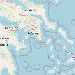
Map view of Sounio National Park

Use this park location map to pinpoint Sounio National Park in Greece, understand its exact geographic position, and read its mapped placement within the surrounding landscape more clearly.

Pigeon | © OpenStreetMap contributors
Park atlas

Compare coastal landscapes, rocky headlands, and neighboring protected zones.

Parks Near Sounio National Park and Protected Areas in the Surrounding Region

Browse other parks near Sounio National Park to examine related coastal terrain, Mediterranean scrub, and protected regional landscapes. Comparing adjacent nature reserves provides deeper context for the geography of the surrounding Attic peninsula.
A horizontal watercolor painting showing a soft mountain landscape with green forests and a central light-colored area under a pale sky.
National parkGreece
About 64 km away#1 closest

Northwest

Parc national du Parnès: Geographic Overview of the Attica Peninsula's Protected Massif

Explore the karst gorges, high-altitude fir forests, and protected red deer habitats

Parc national du Parnès dominates the northern skyline of Attica with a complex limestone massif featuring deep ravines like the Keladonas gorge. This atlas entry provides geographic insights into the park's summit network, karst features, and its critical role in Mediterranean forest resilience. Understand the rugged terrain and natural boundaries that define this essential protected area within Greece.

Area
38.16 km²
Established
1961
Relief
Mountain
Climate
Mediterranean
Watercolor illustration of a coastal landscape with hills, trees, and a body of water
Marine protected areaGreece
About 148 km away#2 closest

North

National Marine Park of Alonnisos Northern Sporades: Protected Marine Landscape and Aegean Geography

Explore Greece's largest marine protected area and its vital ecosystems.

Investigate the National Marine Park of Alonnisos Northern Sporades, an extensive marine protected area situated in the northern Aegean Sea. This protected landscape is internationally significant for its role in conserving the Mediterranean monk seal and for its healthy Posidonia oceanica seagrass meadows. Understanding this park's geographic scope and its protected marine terrain offers crucial insights into Mediterranean island ecosystems and conservation efforts within the region.

Area
2,260 km²
Established
1992
IUCN
II
Relief
Mixed relief
A soft, watercolor painting of a mountain range in the distance, featuring a band of evergreen trees in the midground and a grassy foreground on a plain white background.
National parkGreece
About 158 km away#3 closest

Northwest

Parc national du Mont Parnasse: Mapping the Limestone Massif and Alpine Geography of Greece

A protected national park blending karst geology and mountain ecosystems.

Parc national du Mont Parnasse stands as a prominent protected landscape in Central Greece, defined by its fractured limestone geology and subalpine forests. This national park serves as a vital ecological refuge that preserves karst terrain, sinkholes, and diverse Mediterranean mountain habitats rising toward steep alpine summits.

Relief
Mountain
Climate
Mediterranean
Scope
Terrestrial
Water
Minor water
A watercolor painting showing a wide view of the Foloi plateau with rolling hills, a small grove of deciduous trees, and a winding stream, set against a pale background.
Protected areaElis
About 201 km away#4 closest

West

Foloi Oak Forest Protected Area and Plateau Landscape in Elis, Greece

Deciduous mountain woodland and regional plateau geography

Examine the geographic profile of the Foloi Oak Forest, a rare seed-regenerated deciduous woodland spread across an elevated plateau in the Elis region. This protected landscape forms an essential ecological boundary in the western Peloponnese, featuring a dense canopy of Hungarian oak and deep gorges that define the surrounding mountain terrain and local drainage systems.

Area
42 km²
Relief
Upland
Climate
Mediterranean
Access
Moderate access
A soft watercolor illustration of green rolling hills and flat land against a pale, hazy background, representing a coastal island environment.
Nature reserveCrete
About 235 km away#5 closest

South

Agioi Theodoroi Nature Reserve: Protected Island Landscapes off the Coast of Crete

A vital wildlife sanctuary and historical island terrain

The nature reserve of Agioi Theodoroi comprises two small, rocky islands off the northwestern shore of Crete. Known for a long-established population of the rare kri-kri wild goat and breeding colonies of Eleonora's falcons, these islets maintain strict conservation status. Explore the mapped boundaries of this unique protected area and its significance within the coastal geography of the Chania region.

Area
0.697 km²
Established
1930
Relief
Upland
Climate
Mediterranean
Watercolor painting of a wide, rolling landscape with a forested horizon and distant mountains, rendered in soft, muted tones of pink, green, and gold on a white background.
Natural monumentLesvos
About 236 km away#6 closest

Northeast

Lesvos Petrified Forest: Protected Volcanic Fossil Landscapes and Aegean Geological Atlas

Natural monument and ancient Miocene fossil forest zones in western Lesvos, Greece.

This protected natural monument preserves an early Miocene forest transformed into stone by volcanic activity. The landscape features fossilized coniferous trunks, including rare upright specimens, scattered throughout volcanic deposits and coastal andesite outcrops on the island of Lesvos. It serves as a vital reference for the geological history of the North Aegean region.

Area
150 km²
Established
1985
Relief
Upland
Climate
Subtropical
A watercolor painting showing a soft, atmospheric landscape with a pink-toned lagoon in the foreground, green hills in the midground, and a hazy purple mountain in the background.
National parkGrèce-Occidentale
About 250 km away#7 closest

West

Parc national de Missolonghi-Etolikó: Coastal Lagoons and Limestone Geography

Protected wetlands and river delta landscapes in Western Greece

Tracing the interface of the Acheloos and Evinos river deltas with the Ionian Sea, this national park protects a mosaic of saltpans, reedbeds, and mountain massifs. Its mapped boundaries encompass the historic Missolonghi lagoon, the vertical limestone cliffs of Mount Varasova, and rare riverine woodlands, providing a detailed look at one of the most vital wetland complexes in the Mediterranean.

Area
360.73 km²
Established
2006
IUCN
VI
National parkAydın Province
About 262 km away#8 closest

East

Dilek Peninsula-Büyük Menderes Delta National Park: Protected Landscape and Geographic Context

Aydın Province's unique national park with diverse ecosystems.

Investigate Dilek Peninsula-Büyük Menderes Delta National Park, a key protected area in Turkey's Aydın Province. This page provides detailed geographic context, highlighting the park's remarkable coexistence of mountainous terrain and essential wetland habitats. Understand the mapped boundaries and landscape characteristics that define this significant national park.

Area
275.98 km²
Established
1966
IUCN
II
Visitors
700K annual

Common questions about visiting, size, designation, and location context for Sounio National Park

Sounio National Park FAQs for park facts, access, geography, and protected area context

Find quick answers about Sounio National Park, including protected-area facts, park geography, trail and visitor context, and how the park fits into its surrounding country and regional landscape.
MoriAtlas Explorer

Continue Your Protected Areas Search Across the Global Atlas

Deepen your exploration by continuing the structured search for national parks and protected areas worldwide. Utilize the comprehensive filtering capabilities to compare different conservation landscapes and refine your understanding of global park geography. Discover more about the distribution and characteristics of protected natural areas.

Global natural geography