
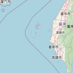
Islands
Park geography
Detailed assessment of marine boundaries, island distribution, and coastal landscape characteristics
Structured Geographical and Terrain Profile of South Penghu Marine National Park, Taiwan
This geographic profile provides a comprehensive overview of South Penghu Marine National Park, encompassing its total area of 358.44 square kilometers. The analysis details the specific marine and land composition, structural boundaries, and diverse terrain features including various islands, cliffs, and coastal habitats throughout this subtropical region.
Related tags
Marine National ParkCoral ReefsBasalt LandformsVolcanic IslandsPenghu Islands
Taiwan's marine wilderness protecting basalt islands and thriving coral ecosystems in the Penghu archipelago
South Penghu Marine National Park
South Penghu Marine National Park is a marine protected area established in 2014 in the southern Penghu Islands of Taiwan. The park encompasses four main islands Dongjiyu, Xijiyu, Dongyupingyu, and Xiyupingyu, along with several smaller islets and their surrounding marine waters totaling approximately 358 square kilometers. This marine park represents one of Taiwan's newest national parks and is managed by the Marine National Park Headquarters. The islands feature dramatic columnar basalt formations, sea caves including the famous Blue Cave, and a landscape dotted with abandoned stone houses and traditional wind-protection walls. The surrounding waters are part of the warm Kuroshio Current system, supporting rich coral reef ecosystems and diverse marine life. Once home to thousands of residents, the islands now have only about 50 inhabitants, leaving behind a cultural landscape of historical buildings and temples that add to the park's distinctive character.
- Location
- Taiwan
- Park type
- National park
- Established
- 2014
- Area
- 358.4 km²
Location overview
Coastal and Island Status within Penghu and Wang'an Township
Geographic Overview of South Penghu Marine National Park
South Penghu Marine National Park is located within Taiwan, American Samoa, Penghu, and Wang'an Township. Records confirm its status as a coastal, island, and marine protected area under regional jurisdiction.
- Countries
- Taiwan
- Regions
- Penghu, Wang'an Township
- Primary location
- Taiwan
- Geographic setting
- Coastal · Island · Marine
Boundary and coordinates
Interactive boundary geometry and derived spatial measurements
South Penghu Marine National Park Boundary Map and Spatial Extent
Mapped outlines provide spatial context for evaluating the protected area configuration. Accompanying measurements detail total area coverage and coordinate limits across the marine zone.
- Boundary area
- 353.7 km²
- Boundary perimeter
- 79.2 km
- Northernmost point
- 23.3244° N
- Southernmost point
- 23.2014° N
- Easternmost point
- 119.7178° E
- Westernmost point
- 119.4642° E
- Geographic centre
- 23.2629° N, 119.591° E
- North–south span
- 13.6 km
- East–west span
- 26 km
Terrain and natural features
Stored lowland relief classifications and recorded island and marine features
South Penghu Marine National Park Terrain and Natural Features
Lowland relief classifications define the landscape alongside recorded islands, bays, beaches, and peaks situated within protected boundaries. Linked feature cards provide names, types, measurements, and spatial relationships for each recorded entry.
Selected named natural features
Islands
東吉
Peaks
八卦山
45 m
Named stones
四仔角
Named stones
香爐礁
Named stones
塔仔
Environmental setting
Subtropical marine and coastal island classifications mapped to regional terrain
South Penghu Marine National Park Environmental Classifications and Physical Setting
Recorded landscape features, climate zones, and dominant water presences outline the physical setting of South Penghu Marine National Park. Categorized data points connect specific environmental attributes to broader atlas destinations across the protected territory.
- Relief
- Lowland
- Climate
- Subtropical
- Water
- Water-dominated
- Forest cover
- No forest cover
- Seasonality
- Seasonal
Landscape features
Islands · Cliffs · Cave · Coast
Habitat types
Coastal habitat · Marine habitat
Park atlas
Explore the regional geography of other protected areas, comparing their features across the Penghu Islands.
Discover Other Protected Areas and National Parks Near South Penghu Marine National Park
Browse other national parks and protected areas with similar marine or island characteristics, extending your exploration beyond South Penghu Marine National Park into nearby geographic regions. Comparing these conservation landscapes provides valuable atlas context for understanding the broader protected-area network and distinct ecological features across the Penghu Islands region.
National parkTainan
Park boundaries overlap#1 closest
Southeast

Taijiang National Park: National Park Atlas and Protected Landscape Exploration
Discover mapped boundaries and regional geography.
Taijiang National Park offers a distinct look into protected natural landscapes within Tainan, Taiwan. This page details its identity as a national park, focusing on its mapped geographic features and its contribution to the regional atlas. Users can explore the specific protected area context and understand the landscape characteristics relevant to a structured geographic discovery approach.
- Area
- 393.1 km²
- Established
- 2009
- IUCN
- II
- Relief
- Lowland
Nature reserveTaiwan
About 84 km away#2 closest
Southeast
Shoushan National Nature Park: Protected Nature Reserve Landscape and Mapped Geography
Taiwan's protected nature reserve with distinct geographic features.
Shoushan National Nature Park is identified as a protected nature reserve, providing a focal point for exploring Taiwan's natural geography. This page offers insights into its specific landscape character and mapped protected boundaries, situating it within the broader context of the island's natural terrain. Discover the atlas-level details of this reserve and its role in regional conservation landscapes.
National parkNantou County
113 km away#3 closest
East
Yushan National Park: Explore Taiwan's Highest Mountain and Alpine Protected Terrain
Mapped geography and dramatic peaks within Nantou County.
Yushan National Park is a crucial protected area in Taiwan, renowned for encompassing the island's highest mountain and a significant portion of the Central Mountain Range. This national park's dramatic geography spans over 103,000 hectares, with two-thirds of its territory lying above 2,000 meters. Its vertical ecological zones, from subtropical forests to alpine environments, offer a rich tapestry of landscapes ideal for atlas-style exploration of protected terrain and mountain peak geography.
- Area
- 1,031.21 km²
- Established
- 1985
- IUCN
- II
- Visitors
- 1M annual
National parkPingtung County
161 km away#4 closest
Southeast
Kenting National Park: Taiwan's Southern National Park Protected Landscape Identity
Mapped geography and regional context for this protected area.
Kenting National Park is a crucial protected area located in Pingtung County, Taiwan, representing a significant component of the nation's protected lands. This page provides detailed information ideal for atlas-driven exploration, focusing on the park's mapped geographic features, its role as a national park, and its contribution to understanding Taiwan's diverse landscapes. Discover the unique identity of Kenting National Park as a key element in regional conservation and geographic study.
- Area
- 333 km²
- Established
- 1984
- IUCN
- II
- Visitors
- 5.8M annual
National parkKinmen County
161 km away#5 closest
Northwest
Kinmen National Park: National Park Protected Landscape and Geographic Context
Mapped boundaries and regional park geography for atlas exploration.
Kinmen National Park stands as a significant protected area within Kinmen County, Taiwan. This page focuses on its identity as a national park, detailing its mapped boundaries and contributing to an understanding of its regional geographic context. It is designed for users seeking to explore the park's protected landscape features and its position within the broader atlas of natural areas.
- Area
- 35.29 km²
- Established
- 1995
- IUCN
- II
- Relief
- Upland
National parkMiaoli County
172 km away#6 closest
Northeast
Shei-Pa National Park: Explore Taiwan's National Park Protected Landscape in Miaoli County
Mapped geographic boundaries and regional park context.
Shei-Pa National Park is a vital protected area in Miaoli County, Taiwan, offering rich opportunities for geographic and atlas-based exploration. Delve into the specifics of its mapped park boundaries and understand its role within the broader regional landscape. This destination provides essential context for discovering Taiwan's protected natural areas and their unique geographic characteristics.
- Area
- 768.5 km²
- Established
- 1992
- IUCN
- II
- Relief
- Mountain
National parkHualien County
178 km away#7 closest
Northeast
Taroko National Park: Detailed National Park Geography and Protected Landscape Context
Explore mapped boundaries and natural terrain in Hualien County.
Taroko National Park represents a significant protected landscape within Taiwan, offering rich opportunities for geographical exploration and understanding protected-area distribution. As a designated national park, its mapped boundaries and unique terrain provide essential context for appreciating the natural geography of Hualien County and the surrounding region. This page supports detailed discovery of Taroko National Park's identity as a distinct protected area, ideal for atlas-based research and landscape comprehension.
- Area
- 920 km²
- Established
- 1986
- IUCN
- II
- Relief
- Mountain
National parkTaiwan
About 276 km away#8 closest
Northeast
Yangmingshan National Park: Volcanic Terrain and Geothermal Features Atlas
Explore Taiwan's protected national park geography and mapped landscapes.
Yangmingshan National Park presents a striking example of volcanic geography, characterized by its rugged mountain terrain, active craters like Xiaoyoukeng, and ubiquitous geothermal features such as hot springs and sulfur deposits. As a protected national park within Taiwan, its landscape offers a rich context for understanding volcanic processes and alpine ecosystems. MoriAtlas provides detailed map exploration of Yangmingshan National Park, highlighting its unique geological formations and protected boundaries for an in-depth geographic discovery experience.
- Area
- 113 km²
- Established
- 1985
- IUCN
- II
MoriAtlas Explorer
Continue Exploring the Geography and Protected Landscapes of South Penghu Marine National Park
Delve deeper into the specific protected landscape of South Penghu Marine National Park, understanding its geographic context within Taiwan and its unique marine atlas features. This exploration offers insight into volcanic terrain, mapped marine boundaries, and the natural systems that define this protected area, furthering your understanding of regional protected lands.
Browse next
Global natural geography
Explore related park routes
Explore MoriAtlas Global ParksBrowse All MoriAtlas ParksGlobal Park Map DiscoveryMoriAtlas: Browse All CountriesBrowse All MoriAtlas ContinentsNational Park Environment AtlasGrand Canyon National Park AtlasYellowstone National Park AtlasYosemite National Park Atlas and GeographySerengeti National Park AtlasGalápagos National Park Protected LandscapeBanff National Park Geography and AtlasKruger National Park Atlas EntryUluṟu-Kata Tjuṯa National Park AtlasExplore Uluru-Kata Tjuta National Park GeographyPlitvice Lakes National Park AtlasFiordland National Park Protected LandscapeGreat Smoky Mountains National Park AtlasAfghanistan National Parks and Protected AreasAlbania National Parks and Protected AreasAlgeria National Parks and Protected AreasAmerican Samoa National Parks and Protected AreasAndorra National Parks and Protected AreasAngola National Parks and Protected AreasAntarctica National Parks and Protected AreasAntigua and Barbuda Park List