

Mori Atlas logo
National parkTaijiang National Park

Discover the mapped natural terrain and protected area identity of this national park.

Taijiang National Park: Protected Landscape, Mapped Boundaries, and Geographic Context in Tainan

Taijiang National Park represents a significant protected area within the geographic landscape of Tainan, Taiwan. This entry provides detailed context for understanding its role as a national park, focusing on its mapped boundaries and the regional geography it occupies. Explore the specific natural terrain and the atlas significance of Taijiang National Park to gain a clear perspective on its protected landscape identity.

Coastal WetlandsMangrove ForestsTidal FlatsMarine Protected AreaBirdwatchingEstuarine Ecosystem

Taijiang National Park

National park

Park overview

Structured park overview, official facts, and landscape profile for Taijiang National Park

Taijiang National Park park facts, protected area profile, and essential visitor context
Review the core facts for Taijiang National Park, including designation, size, terrain, visitor scale, habitats, and operating context in one park-focused overview.

About Taijiang National Park

Taijiang National Park occupies a distinctive position among Taiwan's protected areas as the nation's first national park to focus primarily on coastal wetland and shallow marine ecosystems. The park is located entirely within the administrative boundaries of Tainan, Taiwan's oldest city and a region with deep historical significance dating to the Dutch colonial period in the 17th century. The landscape within the park consists predominantly of tidal flats, mangrove forests, salt marshes, and coastal sandbars, interspersed with man-made fishing harbors and traditional aquaculture ponds. The park's marine component extends along a narrow band of shallow coastal water, protecting the ecological integrity of the nearshore environment and the transition zone between land and sea. Unlike Taiwan's mountainous national parks that preserve high-elevation forest ecosystems, Taijiang provides protection for the low-lying coastal environments that characterize much of Taiwan's western shoreline. The park's establishment in 2009 reflected Taiwan's growing commitment to wetland conservation and recognition of the ecological and cultural value of its coastal landscapes.

Quick facts and research context for Taijiang National Park

Taijiang National Park covers approximately 393 square kilometers along Taiwan's southwestern coast, with about 49 square kilometers of terrestrial land and 344 square kilometers of marine area. The park extends from the southern sea wall of Qingshan Fishing Harbor south to the Yanshui River, spanning roughly 20.7 kilometers north to south. The westernmost point on the island of Taiwan, Guosheng Port Lighthouse, falls within the park's boundaries. The marine zone extends 20 meters from the shoreline and stretches 54 kilometers along the coast from the Yanshui River to Dongji Island. The park was officially established on October 15, 2009, and is managed by the Taijiang National Park Headquarters under Taiwan's National Park Service.

Park context

Deeper park guide and search-rich context for Taijiang National Park

Taijiang National Park history, landscape, wildlife, and travel context
Explore Taijiang National Park through its history, landscape character, ecosystems, wildlife, conservation priorities, cultural context, and seasonal travel timing in a structured park guide built for atlas discovery and search intent.

Why Taijiang National Park stands out

Taijiang National Park is best known for its extensive mangrove forests, which form dense tunnel-like canopies along the park's waterways and tidal channels. The park protects one of Taiwan's most significant coastal wetland ecosystems, comprising mudflats, tidal marshes, and shallow marine environments that support diverse birdlife and marine organisms. The park also preserves the historical memory of the former Taijiang Lagoon, a 17th-century water body that was once a harbor area used by Dutch colonists and local fishermen before sedimentation transformed it into land over the past three centuries.

Taijiang National Park history and protected-area timeline

The history of Taijiang National Park is intimately tied to the geological and human history of the Tainan coast. During the 17th century, when Dutch colonists established settlements in Taiwan, the area contained a substantial body of water known as Taijiang Lagoon, which served as a natural harbor and fishing ground. This lagoon was navigable and functioned as an important waterway for the colonial settlement of Taiwan. Over the following century, the lagoon gradually filled with sediment carried by rivers flowing from the western slopes of the Taiwan Central Mountain Range. The process of land formation continued incrementally, transforming the open water into tidal flats and eventually into coastal land. By the 18th century, the lagoon had largely ceased to exist as a distinct water body. The modern landscape that emerged includes extensive wetlands, mudflats, and the mangrove forests that now characterize the park. Taijiang National Park was formally established on October 15, 2009, making it one of Taiwan's younger national parks. The park's creation acknowledged both the ecological importance of the remaining wetland ecosystems and the historical significance of the lagoon that once defined this coastline.

Taijiang National Park landscape and geographic character

The landscape of Taijiang National Park is defined by the interaction between terrestrial and marine environments along a low-lying coastal margin. The terrain is predominantly flat, with elevation rarely exceeding a few meters above sea level. The park encompasses extensive tidal flats that are exposed at low tide and submerged at high tide, creating a dynamic and ever-changing visual environment. Mangrove forests dominate the vegetated areas, with species adapted to survive in constantly flooded, saline soils forming dense stands along waterways and tidal channels. The park includes several sandbars, such as Dingtou Sandbar, which emerge from the coastal waters and provide important habitats for shorebirds and nesting species. Along the coastline, the terrain includes man-made structures such as sea walls, fishing harbors, and the historic Guosheng Port Lighthouse, which marks the westernmost point on the island of Taiwan. The marine portion of the park consists of shallow coastal waters extending 20 meters from the shore, a zone that supports productive fisheries and serves as a nursery area for many marine species.

Taijiang National Park ecosystems, habitats, and plant life

The nature of Taijiang National Park centers on its coastal wetland ecosystems, which represent some of the most biologically productive environments in Taiwan. The mangrove forests within the park provide critical habitat for juvenile fish, crustaceans, and mollusks, while also serving as natural filters that improve water quality and stabilize shorelines against erosion. The tidal flats support vast communities of benthic organisms, including worms, clams, and crustaceans, which in turn provide food for migratory shorebirds that use the East Asian-Australasian flyway. The shallow marine waters within the park's boundaries contain seagrass beds and coral communities that contribute to marine biodiversity. The interface between fresh water from rivers like the Yanshui River and the salt water of the Taiwan Strait creates a dynamic estuarine environment with high ecological productivity. These habitats collectively support a remarkable diversity of species, from microscopic organisms to large predatory fish and marine mammals that occasionally enter the coastal waters.

Taijiang National Park wildlife and species highlights

Taijiang National Park supports significant wildlife populations, particularly among bird species that rely on coastal wetlands. The mudflats and tidal channels provide crucial foraging grounds for migratory shorebirds that travel along the East Asian-Australasian flyway, with species including plovers, sandpipers, and godwits stopping to rest and feed during their seasonal journeys. The mangrove forests serve as nesting and roosting sites for egrets, herons, and kingfishers, while also providing refuge for various species of terrestrial birds. The marine environment within the park supports fish, shrimp, crabs, and shellfish that form the basis of local fishing economies. The tidal channels and mangrove swamps are home to mudskippers, a distinctive fish species adapted to survive out of water, as well as various amphibians and reptiles that tolerate the brackish environment. The park's location along the western Taiwan coast places it within a region that experiences seasonal fluctuations in wildlife activity, with migration periods bringing the greatest diversity of species.

Taijiang National Park conservation status and protection priorities

Taijiang National Park was established to protect one of Taiwan's most important coastal wetland ecosystems from development pressure and environmental degradation. The coastal regions of southwestern Taiwan have historically been subject to land reclamation, aquaculture expansion, and industrial development, which have reduced the extent of natural wetlands throughout the region. By designating this area as a national park, Taiwan has committed to preserving the remaining mangrove forests, tidal flats, and shallow marine environments that provide critical ecological services. The park's protected status helps maintain water quality, protect coastal biodiversity, and preserve the landscape's capacity to buffer storm surges and coastal erosion. The park also contributes to international conservation efforts by providing protected habitat for migratory bird species that traverse the East Asian-Australasian flyway. Management of the park focuses on balancing ecological preservation with the traditional livelihoods of local fishing communities whose activities have shaped the landscape for generations.

Taijiang National Park cultural meaning and human context

The cultural context of Taijiang National Park is deeply intertwined with the historical development of Tainan, Taiwan's oldest city and a region of significant colonial heritage. The former Taijiang Lagoon was a notable geographical feature during the Dutch colonial period in the 17th century, serving as a maritime gateway for the settlement of Taiwan. Dutch merchants and colonists established trading relationships and built fortifications in the region, leaving a legacy of place names and historical associations that persist in the modern park's naming. The landscape within the park contains evidence of human modification over centuries, including traditional aquaculture ponds, fishing villages, and coastal fortifications. Local fishing communities continue to operate within and around the park boundary, maintaining traditional practices that are compatible with conservation objectives. The park's establishment reflects a growing recognition in Taiwan of the need to preserve not only natural ecosystems but also the cultural landscapes that reflect the nation's complex history of colonization, settlement, and adaptation to the coastal environment.

Top sights and standout views in Taijiang National Park

The highlights of Taijiang National Park include its extensive mangrove tunnel networks, which create a unique visual experience as visitors traverse waterways beneath dense forest canopies. The park's position at the western edge of Taiwan offers opportunities to observe both coastal sunrise and sunset views across the Taiwan Strait. The presence of Guosheng Port Lighthouse provides a historical landmark and the westernmost point of the island. The tidal flats undergo dramatic transformations between high and low tide, revealing different aspects of the park's ecology and creating dynamic landscapes that change throughout the day. The park's relatively recent establishment and its focus on coastal wetland ecosystems distinguish it from Taiwan's other national parks, which primarily protect mountainous forest environments.

Best time to visit Taijiang National Park

The best time to visit Taijiang National Park depends on the type of experience desired, but the park can be appreciated year-round given its coastal wetland setting. The winter months from November to February bring migratory shorebirds to the mudflats, making this an excellent period for birdwatching enthusiasts. The summer months offer warmer temperatures and longer daylight hours, providing more time for exploration of the mangrove channels and tidal areas. The park's wetland environment means that visit timing is affected by tidal cycles rather than calendar seasons alone, as the exposure of mudflats and accessibility of certain areas vary with the tide. Visitors interested in experiencing the full scope of the park's landscapes should consider both the season and tidal conditions when planning their trip.
Park location guide

Geography guide, regional context, and park location map for Taijiang National Park

Taijiang National Park park geography, regions, and map view in Taiwan
Understand where Taijiang National Park sits in Taiwan through a broader geographic reading of the surrounding landscape, nearby location context, and its mapped position within the national park landscape.

How Taijiang National Park fits into Taiwan

Taiwan is an island nation in East Asia situated between the East China Sea and South China Sea. With a population of approximately 23.3 million people, it is one of the most densely populated countries in the world. The island features mountain ranges dominating its eastern region and densely populated plains in the west, where major cities including Taipei and New Taipei City are located.

Wider geography shaping Taijiang National Park in Taiwan

Taiwan is located in the western Pacific Ocean, bordered by the East China Sea to the northwest and the South China Sea to the southwest. The People's Republic of China lies to the northwest across the Taiwan Strait, Japan is to the northeast, and the Philippines are to the south. The main island features mountain ranges dominating the eastern two-thirds of the territory, with plains concentrated in the western third where the majority of the population resides.

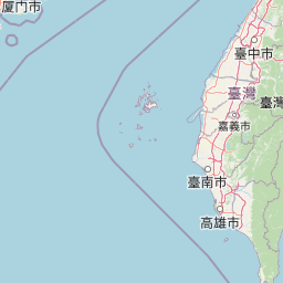
Map view of Taijiang National Park

Use this park location map to pinpoint Taijiang National Park in Taiwan, understand its exact geographic position, and read its mapped placement within the surrounding landscape more clearly.

Pigeon | © OpenStreetMap contributors
Park atlas

Compare diverse protected landscapes and regional park geography around Taijiang National Park in Taiwan.

Explore Other National Parks and Coastal Protected Areas Near Taijiang National Park
Browse a curated list of national parks and coastal protected areas located geographically near Taijiang National Park, tracing the spread of conservation landscapes across Taiwan's southwestern region. Deepen your understanding of regional biodiversity and unique ecosystems by comparing these protected areas, focusing on their distinct wetland, marine, and historical coastal attributes.
National parkTaiwan

South Penghu Marine National Park: A Protected Volcanic Island Landscape in Taiwan's Penghu Archipelago

Mapped marine protected areas and unique geological features.

Discover the unique atlas value of South Penghu Marine National Park, Taiwan's protected national park renowned for its dramatic columnar basalt landforms and extensive coral reef systems. This marine protected area provides critical habitat for diverse species and showcases a rugged island geography shaped by volcanic activity. Explore its mapped boundaries and unique geological formations, including famous sea caves, offering a distinct context for landscape discovery.

Area
358.44 km²
Established
2014
IUCN
II
Visitors
8.4K annual
National parkNantou County

Yushan National Park: Explore Taiwan's Highest Mountain and Alpine Protected Terrain

Mapped geography and dramatic peaks within Nantou County.

Yushan National Park is a crucial protected area in Taiwan, renowned for encompassing the island's highest mountain and a significant portion of the Central Mountain Range. This national park's dramatic geography spans over 103,000 hectares, with two-thirds of its territory lying above 2,000 meters. Its vertical ecological zones, from subtropical forests to alpine environments, offer a rich tapestry of landscapes ideal for atlas-style exploration of protected terrain and mountain peak geography.

Area
1,031.21 km²
Established
1985
IUCN
II
Visitors
1M annual
National parkPingtung County

Kenting National Park: Taiwan's Southern National Park Protected Landscape Identity

Mapped geography and regional context for this protected area.

Kenting National Park is a crucial protected area located in Pingtung County, Taiwan, representing a significant component of the nation's protected lands. This page provides detailed information ideal for atlas-driven exploration, focusing on the park's mapped geographic features, its role as a national park, and its contribution to understanding Taiwan's diverse landscapes. Discover the unique identity of Kenting National Park as a key element in regional conservation and geographic study.

Area
333 km²
Established
1984
IUCN
II
Visitors
5.8M annual
National parkHualien County

Taroko National Park: Detailed National Park Geography and Protected Landscape Context

Explore mapped boundaries and natural terrain in Hualien County.

Taroko National Park represents a significant protected landscape within Taiwan, offering rich opportunities for geographical exploration and understanding protected-area distribution. As a designated national park, its mapped boundaries and unique terrain provide essential context for appreciating the natural geography of Hualien County and the surrounding region. This page supports detailed discovery of Taroko National Park's identity as a distinct protected area, ideal for atlas-based research and landscape comprehension.

Area
920 km²
Established
1986
IUCN
II
Relief
Mountain
National parkMiaoli County

Shei-Pa National Park: Explore Taiwan's National Park Protected Landscape in Miaoli County

Mapped geographic boundaries and regional park context.

Shei-Pa National Park is a vital protected area in Miaoli County, Taiwan, offering rich opportunities for geographic and atlas-based exploration. Delve into the specifics of its mapped park boundaries and understand its role within the broader regional landscape. This destination provides essential context for discovering Taiwan's protected natural areas and their unique geographic characteristics.

Area
768.5 km²
Established
1992
IUCN
II
Relief
Mountain
National parkKinmen County

Kinmen National Park: National Park Protected Landscape and Geographic Context

Mapped boundaries and regional park geography for atlas exploration.

Kinmen National Park stands as a significant protected area within Kinmen County, Taiwan. This page focuses on its identity as a national park, detailing its mapped boundaries and contributing to an understanding of its regional geographic context. It is designed for users seeking to explore the park's protected landscape features and its position within the broader atlas of natural areas.

Area
35.29 km²
Established
1995
IUCN
II
Relief
Upland
National parkTaiwan

Yangmingshan National Park: Volcanic Terrain and Geothermal Features Atlas

Explore Taiwan's protected national park geography and mapped landscapes.

Yangmingshan National Park presents a striking example of volcanic geography, characterized by its rugged mountain terrain, active craters like Xiaoyoukeng, and ubiquitous geothermal features such as hot springs and sulfur deposits. As a protected national park within Taiwan, its landscape offers a rich context for understanding volcanic processes and alpine ecosystems. MoriAtlas provides detailed map exploration of Yangmingshan National Park, highlighting its unique geological formations and protected boundaries for an in-depth geographic discovery experience.

Area
113 km²
Established
1985
IUCN
II
National parkOkinawa Prefecture

Iriomote-Ishigaki National Park: Subtropical Island Geography and Protected Landscape Atlas

Explore the unique terrain and mapped boundaries of this national park.

Dive into the geography of Iriomote-Ishigaki National Park, a protected national park situated in Japan's Okinawa Prefecture. This page provides a detailed atlas view of its characteristic subtropical island terrain, including extensive mangrove forests, distinct limestone karst features, and surrounding marine protected areas. Understand the park's unique landscape and its significance within the broader regional geography for comprehensive exploration.

Area
1,221.5 km²
Established
1972
IUCN
II
Climate
Subtropical

Common questions about visiting, size, designation, and location context for Taijiang National Park

Taijiang National Park FAQs for park facts, access, geography, and protected area context
Find quick answers about Taijiang National Park, including protected-area facts, park geography, trail and visitor context, and how the park fits into its surrounding country and regional landscape.
MoriAtlas Explorer

Continue Your Protected Areas Search Across the Global Atlas

Deepen your exploration by continuing the structured search for national parks and protected areas worldwide. Utilize the comprehensive filtering capabilities to compare different conservation landscapes and refine your understanding of global park geography. Discover more about the distribution and characteristics of protected natural areas.

Global natural geography