

Mori Atlas logo
National parkTaroko National Park

Discover the mapped protected boundaries and regional geography of this significant natural area in Hualien County.

Taroko National Park: A Premier National Park in Taiwan with Distinct Geographic Landscapes

Taroko National Park stands as a significant national park within Taiwan, offering a unique opportunity for atlas-driven discovery of its protected landscape and intricate terrain. Situated within Hualien County, this area is defined by its distinctive geography, providing context for understanding the distribution of protected lands and natural features. Explore the mapped boundaries and regional natural context to appreciate the scope of Taroko National Park's landscape and its place in Taiwan's protected areas.

marble gorgemountain parkgeological heritageTaiwan national parksindigenous heritagetectonic landscape

Taroko National Park

National park

Park overview

Structured park overview, official facts, and landscape profile for Taroko National Park

Taroko National Park park facts, protected area profile, and essential visitor context
Review the core facts for Taroko National Park, including designation, size, terrain, visitor scale, habitats, and operating context in one park-focused overview.

About Taroko National Park

Taroko National Park occupies a remarkable position in Taiwan's landscape, protecting a corridor of extraordinary terrain that forms the eastern edge of the Central Mountain Range. The park's centerpiece, Taroko Gorge, represents a geological phenomenon of international significance. The gorge was carved by the Liwu River as the land was uplifted through the continuing collision of the Philippine and Eurasian tectonic plates, a process that began roughly four million years ago and continues today with the land rising a few millimeters annually. The marble that forms the gorge walls was originally calcium carbonate deposits accumulated approximately 230 million years ago, which through time, pressure, and metamorphosis transformed first into limestone and then into the pure white marble that characterizes the canyon. Visitors to the park encounter a landscape of extraordinary vertical relief, with gorge walls rising hundreds of meters above the river while the surrounding terrain includes peaks exceeding 3,000 meters, alpine meadows, and cascading waterfalls. The park's accessibility from Hualien City makes it one of Taiwan's most visited protected areas, though the 2024 earthquake caused significant disruption to the landscape and infrastructure, with substantial portions of the park remaining closed for recovery. The park's management balances visitor access with protection of its sensitive geological and ecological resources, maintaining trails and viewpoints while allowing the landscape to recover from natural disturbances.

Quick facts and research context for Taroko National Park

Taroko National Park covers 920 square kilometers in eastern Taiwan, established in its current form on 28 November 1986 though originally designated during Japanese colonial rule in 1937. The park spans three administrative regions: Hualien County, Taichung City, and Nantou County, with its entrance near Xiulin Township. Twenty-seven peaks within the park exceed 3,000 meters, with the Qilai and Nanhu mountain ranges forming the high spine of the protected area. The Central Cross-Island Highway traverses the park from tropical forests at lower elevations to subalpine pine and cedar forests at higher passes. The park is named after the Truku tribe, an indigenous community whose ancestral lands encompass much of the gorge region.

Park context

Deeper park guide and search-rich context for Taroko National Park

Taroko National Park history, landscape, wildlife, and travel context
Explore Taroko National Park through its history, landscape character, ecosystems, wildlife, conservation priorities, cultural context, and seasonal travel timing in a structured park guide built for atlas discovery and search intent.

Why Taroko National Park stands out

Taroko National Park is best known for its extraordinary marble gorge, one of only three river-carved gorges in the world cut entirely through pure marble. The Taroko Gorge, carved by the erosive power of the Liwu River over millions of years, presents walls of white and gray marble rising dramatically above the rushing waters below. The park's geological significance stems from the marble formations that were revealed after millions of years of erosion and uplift from the collision of tectonic plates. The landscape features the Tunnel of Nine Turns, Eternal Spring Shrine, Zhuilu Cliff, and the spectacular Qingshui Cliffs where the coastline rises sharply from the ocean. The combination of geological rarity, dramatic vertical terrain, and the cultural presence of the Truku people makes this park one of Taiwan's most distinctive protected areas.

Taroko National Park history and protected-area timeline

Taroko National Park traces its origins to the Japanese colonial period, when Taiwan was part of the Empire of Japan. The park was originally established as the Tsugitaka-Taroko National Park by the Governor-General of Taiwan on 12 December 1937, making it one of East Asia's earliest designated national parks. Following Japan's defeat in World War II, the Republic of China assumed control of Taiwan in 1945, and the national park designation was abolished on 15 August of that year. For four decades, the area remained without formal protected area status despite its exceptional geological and scenic value. The park was finally reestablished in its current form on 28 November 1986, restoring protection to the gorge and surrounding mountains. In 2002, the park was named a potential World Heritage Site, recognizing its outstanding universal value. The year 2021 marked the park's 35th anniversary, commemorated by Google with a homepage doodle. However, 2024 brought significant challenges when a magnitude 7 earthquake struck Taiwan's eastern coast, causing widespread devastation including landslides that blocked the Central Cross-Island Highway through Taroko Gorge and trapping hundreds of visitors. The earthquake and subsequent flooding in 2024 resulted in extensive damage to the park's landscape and infrastructure, with much of the park remaining closed as of 2025.

Taroko National Park landscape and geographic character

The landscape of Taroko National Park is defined by dramatic geological features carved into Taiwan's mountainous interior. The park encompasses a section of the Central Mountain Range that runs north-south through much of Taiwan, with elevations ranging from near sea level at the gorge entrance to peaks exceeding 3,000 meters. The Taroko Gorge itself presents a spectacular canyon with walls of white and gray marble rising steeply on either side of the Liwu River, which continues its erosive work as the land rises around it. The gorge includes notable features such as the Tunnel of Nine Turns, a roadway carved into the canyon wall offering views of the river far below, and the Eternal Spring Shrine, a temple built where a natural spring emerges from the cliff face. Beyond the main gorge, the park includes the towering Zhuilu Cliff, the spectacular coastal Qingshui Cliffs where the mountains meet the Pacific Ocean, and the deeply incised canyon of the Shakadang River. The terrain includes numerous waterfalls along the Baiyang Trail and the high mountain passes such as Dayuling where the vegetation transitions from subtropical to temperate and alpine zones.

Taroko National Park ecosystems, habitats, and plant life

The ecological diversity of Taroko National Park reflects its dramatic range of elevations and the convergence of different climate zones. The park spans from Asian tropical deciduous forests at lower elevations along the river valleys through mixed broadleaf and coniferous forest to high mountain pine and cedar forests at the higher passes. The vertical variation creates distinct ecological zones within relatively short horizontal distances, supporting a variety of plant communities. The marble geology influences soil chemistry and consequently vegetation patterns, with certain plant species adapted to the calcium-rich substrates. The Liwu River and its tributaries support aquatic ecosystems adapted to the fast-flowing, oxygen-rich waters. The park's location along the eastern edge of Taiwan positions it along potential migratory routes for birds, though specific bird species details are limited in the source material. The combination of geological youth, ongoing tectonic activity, and varied elevation creates conditions for endemic species development, though the park's ecological characterization emphasizes the landscape's dynamic nature rather than detailed species inventories.

Taroko National Park wildlife and species highlights

While detailed wildlife inventories are not prominently featured in the available source material, Taroko National Park's diverse habitats support various animal species typical of Taiwan's mountain forests and rocky gorge environments. The vertical terrain and varied elevation create numerous microhabitats supporting different fauna communities. The forest zones at different elevations provide habitat for mammals, while the river systems support fish and other aquatic life. The dramatic cliff faces offer nesting sites for birds, and the gorge's sheltered conditions create microclimates supporting species not found at higher elevations. The Truku people, who have lived in this region for generations, maintained traditional relationships with the land and its resources, suggesting an established ecological relationship between human communities and the park's wildlife. The park's management emphasizes protection of the natural systems, and ongoing recovery work following the 2024 earthquake includes attention to wildlife habitat assessment.

Taroko National Park conservation status and protection priorities

Taroko National Park holds significant conservation value as one of Taiwan's premier protected areas and a potential World Heritage Site. The park protects one of only three river-carved gorges in the world formed entirely in marble, making it geologically irreplaceable on a global scale. The protected area preserves twenty-seven peaks exceeding 3,000 meters, protecting highmountain ecosystems that are increasingly rare in Taiwan. The park's conservation significance extends to the Liwu River system, which continues to shape the marble canyon through ongoing erosion, representing an active geological process that would be destroyed without protection. The designation as IUCN Category II reflects standard national park protections, and the park's management addresses the dual challenges of providing visitor access while maintaining ecological integrity. The 2024 earthquake demonstrated both the park's vulnerability to natural disturbance and the importance of conservation protections in allowing landscape recovery. The park also conserves cultural heritage related to the Truku people, whose ancestral lands overlap substantially with the protected area.

Taroko National Park cultural meaning and human context

Taroko National Park carries deep cultural significance rooted in the presence of the Truku tribe, an indigenous group formally recognized by the Taiwanese government in 2004. The name Taroko itself derives from the Truku people, who originally resided in the upper region of the Zhuoshui River before migrating eastward towards Hualien County through Mount Qilai to the Liwu River basin. The Truku continue to reside in Hualien County, including within areas designated as part of the National Park. The cultural landscape includes historical sites such as the Eternal Spring Shrine and Changuang Temple, which reflect the spiritual significance some visitors find in the dramatic natural environment. The park name represents a collaboration between geological heritage and indigenous cultural identity, making the protected area significant beyond its ecological and scenic value. The Truku perspective on the landscape adds depth to visitor understanding of the area as a lived cultural space rather than merely a scenic attraction.

Top sights and standout views in Taroko National Park

Taroko National Park offers exceptional highlights that make it Taiwan's most famous protected area. The marble canyon of Taroko Gorge stands as the park's signature feature, with its white marble walls rising dramatically above the Liwu River. The Tunnel of Nine Turns provides a memorable driving experience through the canyon walls. The Eternal Spring Shrine offers both religious significance and dramatic gorge views. Zhuilu Cliff presents vertigo-inducing views from one of the gorge's narrowest points. The Qingshui Cliffs stretch along the coast, offering a different landscape from the inland gorges. The Shakadang Trail follows another river canyon into the park's interior. The high mountain passes open to alpine environments with different character from the gorge floor. These diverse features combine within a relatively compact area, allowing visitors to experience remarkable geological, ecological, and cultural variety in a single park visit.

Best time to visit Taroko National Park

Timing a visit to Taroko National Park requires consideration of Taiwan's climate and recent conditions. The park experiences a subtropical climate at lower elevations with significant rainfall, particularly during the summer monsoon season from May through September when typhoons can affect the region. The winter months from December through February generally offer drier conditions, though mountain areas can be cold and occasionally experience snow at higher elevations. Spring and autumn provide moderate temperatures and potentially more stable weather for hiking and sightseeing. However, the 2024 earthquake and subsequent flooding significantly affected park conditions, with much of the park remaining closed as of 2025. Visitors should check current conditions and park status before planning trips, as access restrictions continue to change as recovery progresses. The best general guidance emphasizes checking official park announcements for current trail status and road conditions regardless of season.

Park location guide

Geography guide, regional context, and park location map for Taroko National Park

Taroko National Park park geography, regions, and map view in Taiwan
Understand where Taroko National Park sits in Taiwan through a broader geographic reading of the surrounding landscape, nearby location context, and its mapped position within the national park landscape.

How Taroko National Park fits into Taiwan

Taiwan is an island nation in East Asia situated between the East China Sea and South China Sea. With a population of approximately 23.3 million people, it is one of the most densely populated countries in the world. The island features mountain ranges dominating its eastern region and densely populated plains in the west, where major cities including Taipei and New Taipei City are located.

Wider geography shaping Taroko National Park in Taiwan

Taiwan is located in the western Pacific Ocean, bordered by the East China Sea to the northwest and the South China Sea to the southwest. The People's Republic of China lies to the northwest across the Taiwan Strait, Japan is to the northeast, and the Philippines are to the south. The main island features mountain ranges dominating the eastern two-thirds of the territory, with plains concentrated in the western third where the majority of the population resides.

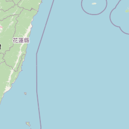
Map view of Taroko National Park

Use this park location map to pinpoint Taroko National Park in Taiwan, understand its exact geographic position, and read its mapped placement within the surrounding landscape more clearly.

Pigeon | © OpenStreetMap contributors

Location context for Taroko National Park

Hualien CountyNantou CountyTaichung
Park atlas

Trace Taiwan's protected landscape geography and compare adjacent national parks, offering a broader atlas view.

National Parks and Protected Areas to Explore Beyond Taroko National Park
After exploring Taroko National Park's unique marble gorge and mountain terrain, continue your protected area discovery by browsing other significant national parks and natural reserves in the surrounding region. Comparing these diverse landscapes provides valuable geographic context for Taiwan's conservation efforts and high-elevation protected areas.
National parkMiaoli County

Shei-Pa National Park: Explore Taiwan's National Park Protected Landscape in Miaoli County

Mapped geographic boundaries and regional park context.

Shei-Pa National Park is a vital protected area in Miaoli County, Taiwan, offering rich opportunities for geographic and atlas-based exploration. Delve into the specifics of its mapped park boundaries and understand its role within the broader regional landscape. This destination provides essential context for discovering Taiwan's protected natural areas and their unique geographic characteristics.

Area
768.5 km²
Established
1992
IUCN
II
Relief
Mountain
National parkNantou County

Yushan National Park: Explore Taiwan's Highest Mountain and Alpine Protected Terrain

Mapped geography and dramatic peaks within Nantou County.

Yushan National Park is a crucial protected area in Taiwan, renowned for encompassing the island's highest mountain and a significant portion of the Central Mountain Range. This national park's dramatic geography spans over 103,000 hectares, with two-thirds of its territory lying above 2,000 meters. Its vertical ecological zones, from subtropical forests to alpine environments, offer a rich tapestry of landscapes ideal for atlas-style exploration of protected terrain and mountain peak geography.

Area
1,031.21 km²
Established
1985
IUCN
II
Visitors
1M annual
National parkTaiwan

Yangmingshan National Park: Volcanic Terrain and Geothermal Features Atlas

Explore Taiwan's protected national park geography and mapped landscapes.

Yangmingshan National Park presents a striking example of volcanic geography, characterized by its rugged mountain terrain, active craters like Xiaoyoukeng, and ubiquitous geothermal features such as hot springs and sulfur deposits. As a protected national park within Taiwan, its landscape offers a rich context for understanding volcanic processes and alpine ecosystems. MoriAtlas provides detailed map exploration of Yangmingshan National Park, highlighting its unique geological formations and protected boundaries for an in-depth geographic discovery experience.

Area
113 km²
Established
1985
IUCN
II
National parkTainan

Taijiang National Park: National Park Atlas and Protected Landscape Exploration

Discover mapped boundaries and regional geography.

Taijiang National Park offers a distinct look into protected natural landscapes within Tainan, Taiwan. This page details its identity as a national park, focusing on its mapped geographic features and its contribution to the regional atlas. Users can explore the specific protected area context and understand the landscape characteristics relevant to a structured geographic discovery approach.

Area
393.1 km²
Established
2009
IUCN
II
Relief
Lowland
National parkTaiwan

South Penghu Marine National Park: A Protected Volcanic Island Landscape in Taiwan's Penghu Archipelago

Mapped marine protected areas and unique geological features.

Discover the unique atlas value of South Penghu Marine National Park, Taiwan's protected national park renowned for its dramatic columnar basalt landforms and extensive coral reef systems. This marine protected area provides critical habitat for diverse species and showcases a rugged island geography shaped by volcanic activity. Explore its mapped boundaries and unique geological formations, including famous sea caves, offering a distinct context for landscape discovery.

Area
358.44 km²
Established
2014
IUCN
II
Visitors
8.4K annual
National parkPingtung County

Kenting National Park: Taiwan's Southern National Park Protected Landscape Identity

Mapped geography and regional context for this protected area.

Kenting National Park is a crucial protected area located in Pingtung County, Taiwan, representing a significant component of the nation's protected lands. This page provides detailed information ideal for atlas-driven exploration, focusing on the park's mapped geographic features, its role as a national park, and its contribution to understanding Taiwan's diverse landscapes. Discover the unique identity of Kenting National Park as a key element in regional conservation and geographic study.

Area
333 km²
Established
1984
IUCN
II
Visitors
5.8M annual
National parkOkinawa Prefecture

Iriomote-Ishigaki National Park: Subtropical Island Geography and Protected Landscape Atlas

Explore the unique terrain and mapped boundaries of this national park.

Dive into the geography of Iriomote-Ishigaki National Park, a protected national park situated in Japan's Okinawa Prefecture. This page provides a detailed atlas view of its characteristic subtropical island terrain, including extensive mangrove forests, distinct limestone karst features, and surrounding marine protected areas. Understand the park's unique landscape and its significance within the broader regional geography for comprehensive exploration.

Area
1,221.5 km²
Established
1972
IUCN
II
Climate
Subtropical
National parkKinmen County

Kinmen National Park: National Park Protected Landscape and Geographic Context

Mapped boundaries and regional park geography for atlas exploration.

Kinmen National Park stands as a significant protected area within Kinmen County, Taiwan. This page focuses on its identity as a national park, detailing its mapped boundaries and contributing to an understanding of its regional geographic context. It is designed for users seeking to explore the park's protected landscape features and its position within the broader atlas of natural areas.

Area
35.29 km²
Established
1995
IUCN
II
Relief
Upland

Common questions about visiting, size, designation, and location context for Taroko National Park

Taroko National Park FAQs for park facts, access, geography, and protected area context
Find quick answers about Taroko National Park, including protected-area facts, park geography, trail and visitor context, and how the park fits into its surrounding country and regional landscape.
MoriAtlas Explorer

Continue Your Protected Areas Search Across the Global Atlas

Deepen your exploration by continuing the structured search for national parks and protected areas worldwide. Utilize the comprehensive filtering capabilities to compare different conservation landscapes and refine your understanding of global park geography. Discover more about the distribution and characteristics of protected natural areas.

Global natural geography