Peaks
Badnjine
2,243 m

A comprehensive look at the land area, elevation extremes, and regional features
This geographic profile details the physical dimensions and environmental characteristics of Sutjeska National Park within Bosnia and Herzegovina. The data includes recorded boundary dimensions spanning 160.52 square kilometers, high-elevation terrain reaching 2386 meters, and documented peaks such as Orlovac and Velika Košuta.

Bosnia's oldest national park protecting primeval forests and the Balkan's highest peaks
Sutjeska National Park is Bosnia and Herzegovina's oldest national park, established in 1962 and located in the southeastern region of the country near the town of Foča. The park encompasses approximately 16,000 hectares of rugged mountain terrain along the border with Montenegro, protecting some of the most significant natural landscapes in the Balkans. At its heart lies Maglić Mountain, which rises to 2,386 meters and stands as Bosnia and Herzegovina's highest peak, straddling the international boundary. The park is renowned for containing Perućica, one of the last remaining primeval forests in Europe, a strict nature reserve where trees have never been logged and some specimens are estimated to be 300 years old. Beyond its ecological significance, the park holds profound historical importance as the site of the Battle of Sutjeska in 1943, a pivotal World War II engagement where Yugoslav Partisans under Marshal Josip Broz Tito successfully broke out of encirclement by German forces.
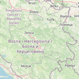
Regional placement and administrative context within Republika Srpska
Sutjeska National Park’s stored boundary covers 160.52 km²
Mountain relief range and recorded natural features
Peaks
2,243 m
Ridges
Peaks
1,803 m
Peaks
1,722 m
Peaks
2,271 m
Lakes
Temperate mountain terrain, major forest cover, and diverse habitats
Mountains · Valleys · Rivers · Lakes · Waterfalls · Forest · Cliffs · Karst
Temperate broadleaf forest · Temperate coniferous forest · Montane forest · Alpine meadow · Grassland · Wetland · Riverine habitat · Karst habitat
Trace the wider mountain landscapes and primeval forests surrounding Sutjeska National Park, comparing protected areas across the Balkans region.

Southeast

High-altitude mountain geography and glacial plateau systems
Durmitor National Park preserves a unique concentration of limestone peaks, deep river gorges, and eighteen glacial lakes within the northern highlands of Montenegro. This protected area showcases the interplay between the massive Tara River Canyon and the high-elevation Jezerska površ plateau, offering a comprehensive look at the diverse mountain terrain that defines this Dinaric Alpine wilderness.
Southeast
Alpine mountain terrain, deep river canyons, and glacial lake ecosystems.
Delve into the geography of Durmitor National Park, a rugged sanctuary in Montenegro that protects spectacular limestone peaks and the dramatic Tara River canyon. This protected area highlights the geological complexity of the Dinaric Alps through its U-shaped valleys, karst features, and diverse alpine meadows that define this significant regional wilderness.

Northeast

Discover Serbia's iconic protected mountain landscape and its unique botanical heritage.
Tara National Park is a significant protected area in Serbia, celebrated for its exceptional botanical value and dramatic mountainous terrain. It is the last refuge for Pančić's spruce, a living fossil conifer, and hosts a remarkable diversity of Balkan flora. The park's landscape is defined by steep limestone cliffs, deep river valleys like the Drina canyon, and expansive forest ecosystems, offering a unique geographic study of protected lands. Explore its mapped features and discover a vital conservation area within the Dinaric Alps.

Northeast

Explore mapped geography and natural landscapes in this Balkan national park.
Drina National Park is a protected area in eastern Bosnia and Herzegovina, celebrated for its striking Drina River canyon landscape. As a national park, it preserves vital habitats for endemic species such as the Serbian spruce and provides a crucial geographic anchor for regional conservation. Its deep gorges and steep slopes offer a rich context for understanding the natural terrain and mapped boundaries within the broader Balkan geography.
Southeast
Protected wilderness in the Bjelasica mountain range of central Montenegro
Biogradska Gora serves as a vital protected area in Montenegro, characterized by its sprawling Bjelasica ridges, six distinct glacial lakes, and primeval beech ecosystems. The park terrain offers an expansive look at Balkan high-mountain geography, ranging from deep forested valleys to alpine meadows and peaks exceeding 2,000 meters in elevation.
South
High-altitude karst massif and Dinaric coastal mountain.
Orjen rises as a dramatic limestone block above the Adriatic coast of Montenegro, forming a high-altitude sanctuary defined by intensive Pleistocene glaciation and record-breaking annual precipitation. This protected landscape encompasses extensive dolines, roches moutonnées, and specialized cold-air refugia, providing a detailed study of sub-Mediterranean highland vegetation and complex subterranean karst drainage.
Southeast
Discover Montenegro's oldest national park with mapped terrain and regional geography.
Biogradska Gora National Park represents a critical protected area in Montenegro, celebrated for its exceptionally well-preserved ancient beech forest. This national park features a heterogeneous terrain of rolling hills and river valleys that create a unique natural setting. The dense, old-growth canopy offers an immersive experience of a primeval forest ecosystem, providing significant value for understanding Balkan nature and protected forest dynamics. Explore the mapped boundaries and discover the distinct landscape character that defines this remarkable natural reserve.
Northeast
Discover Dinaric Alps protected terrain and landscape context.
Zlatibor Protected Landscape offers a distinct exploration of mountainous terrain and protected natural areas in Serbia. Situated in the Dinaric Alps, its landscape is defined by rolling upland plateaus, dense coniferous forests, and open alpine meadows, creating a visually rich environment. The park's geography includes notable karst features and extensive cave systems, complemented by the natural boundaries of significant rivers. Delve into the mapped protected area to understand its landscape character, from the highest peak at Tornik to the unique geological formations and the rare endemic pine subspecies, providing a concrete geographic perspective for atlas-based discovery.
Delve deeper into the mapped terrain and protected area identity of Sutjeska National Park. Understand its role within the broader regional geography and discover the unique characteristics of this significant Balkan natural landscape. MoriAtlas provides structured insights into its ancient forests, mountain peaks, and glacial lakes for comprehensive geographic discovery.