Mori Atlas logo
National parkSutjeska National Park

Discover ancient primeval forests, glacial lakes, and dramatic mountain terrain within this vital protected area.

Sutjeska National Park: Bosnia and Herzegovina's Premier Protected Landscape and Highest Peak

Sutjeska National Park, established in 1962, stands as Bosnia and Herzegovina's oldest national park and a significant protected landscape in the southeastern Balkans. This park preserves a dramatic alpine environment, including Maglić Mountain, the nation's highest peak, and the rare primeval forest of Perućica, a strict nature reserve. Its rugged terrain, deep canyons, and unique glacial lakes offer rich geographic context for atlas-based exploration and understanding the region's natural heritage.

Primeval ForestMountain PeaksGlacial LakesStrict Nature ReserveWWII Historical SiteTransboundary Park
Stylized illustration of a mountainous landscape with a waterfall, forest, and sun.

Sutjeska National Park

National park

Park overview

Structured park overview, official facts, and landscape profile for Sutjeska National Park

Sutjeska National Park park facts, protected area profile, and essential visitor context
Review the core facts for Sutjeska National Park, including designation, size, terrain, visitor scale, habitats, and operating context in one park-focused overview.

About Sutjeska National Park

Sutjeska National Park occupies a remarkable position in southeastern Bosnia and Herzegovina, where the Dinaric Alps create a dramatic backdrop of towering peaks, deep river canyons, and pristine forests. The park's establishment in 1962 marked it as the country's first and largest national park, a distinction it maintains today even as expansion plans would further extend its boundaries. The landscape is defined by a series of parallel mountain ridges rising from the Sutjeska River valley, with Maglić, Volujak, Bioč, and Zelengora forming a natural amphitheater of rock and forest. The park lies along a historic corridor connecting Sarajevo to the Adriatic coast, with the Foča-Tjentište road providing access to the valley where the river has carved a canyon reaching 1,200 meters in depth. This mountainous terrain creates a transitional climatic zone where continental and Mediterranean influences meet, moderated by proximity to the Adriatic Sea. The park's ecological significance extends beyond its borders, forming a transboundary conservation unit with Montenegro's Durmitor National Park, demonstrating decades of regional cooperation in protecting this shared mountain ecosystem.

Quick facts and research context for Sutjeska National Park

Sutjeska National Park spans roughly 160 square kilometers in eastern Bosnia and Herzegovina, covering the basins of the Sutjeska River and its tributaries across the mountains of Maglić, Zelengora, Volujak, and Bioč. The park protects Bosnia's highest peak, Maglić, and contains the strict nature reserve of Perućica, a rare old-growth forest that has never been commercially logged. The park's river systems include the Piva and Drina along its northwestern boundary, the Sutjeska carving a dramatic canyon through the center, and numerous tributaries. Zelengora Mountain hides nine glacial lakes known locally as "Gorske oči" or Eyes of the Mountain. The park is an affiliated member of the EUROPARC Federation and has been the focus of international conservation investment through World Bank-supported biodiversity programs.

Park context

Deeper park guide and search-rich context for Sutjeska National Park

Sutjeska National Park history, landscape, wildlife, and travel context
Explore Sutjeska National Park through its history, landscape character, ecosystems, wildlife, conservation priorities, cultural context, and seasonal travel timing in a structured park guide built for atlas discovery and search intent.

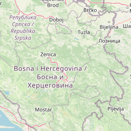
Why Sutjeska National Park stands out

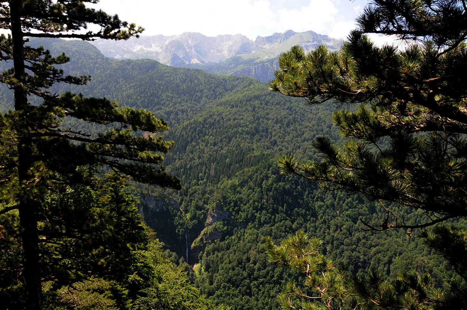
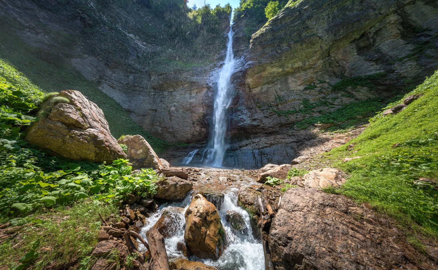
Sutjeska National Park is best known for two distinct treasures: the primeval forest of Perućica, one of Europe's last untouched forests, and the dramatic mountain landscape of Maglić, Bosnia's highest peak. Perućica remains a Strict Nature Reserve where ancient beech forests reaching 60 meters in height have stood for centuries, with the celebrated Skakavac waterfall cascading 75 meters through the forest depths. The park also preserves a network of nine glacial lakes on Zelengora mountain, a rare alpine lake system rarely found elsewhere in the Balkans. The historical significance of the Battle of the Sutjeska adds a layer of human history to the landscape, with memorial monuments at Tjentište commemorating the 1943 Partisan victory.

Mountain valley with green meadows, a small lake, and distant peaks under a blue sky with scattered clouds
Lush green valley with a lake surrounded by mountains in Sutjeska National Park

Sutjeska National Park history and protected-area timeline

The protection history of Sutjeska National Park reflects both natural and cultural priorities. Perućica forest reserve was established in 1952 as a natural reserve for scientific and educational purposes, recognized even then as a unique ecosystem requiring special protection. The national park itself was declared in 1962, initially driven more by the site's historical significance than its ecological value. The decisive factor in establishing the park was the Battle of the Sutjeska, which lasted from May 15 to June 16, 1943, when Yugoslav Partisans under Marshal Josip Broz Tito successfully broke out of a German encirclement despite losing one-third of their forces. From 1958 to 1975, the Memorial Complex at Tjentište was constructed to honor this battle, featuring a monument designed by Miodrag Živković and a ossuary containing the remains of 3,301 Partisan fighters. Following the 1992-1995 war, the park was reorganized as a public enterprise by the Government of the Republic of Srpska in 1996 and admitted to the IUCN's international registry of national parks.

Sutjeska National Park landscape and geographic character

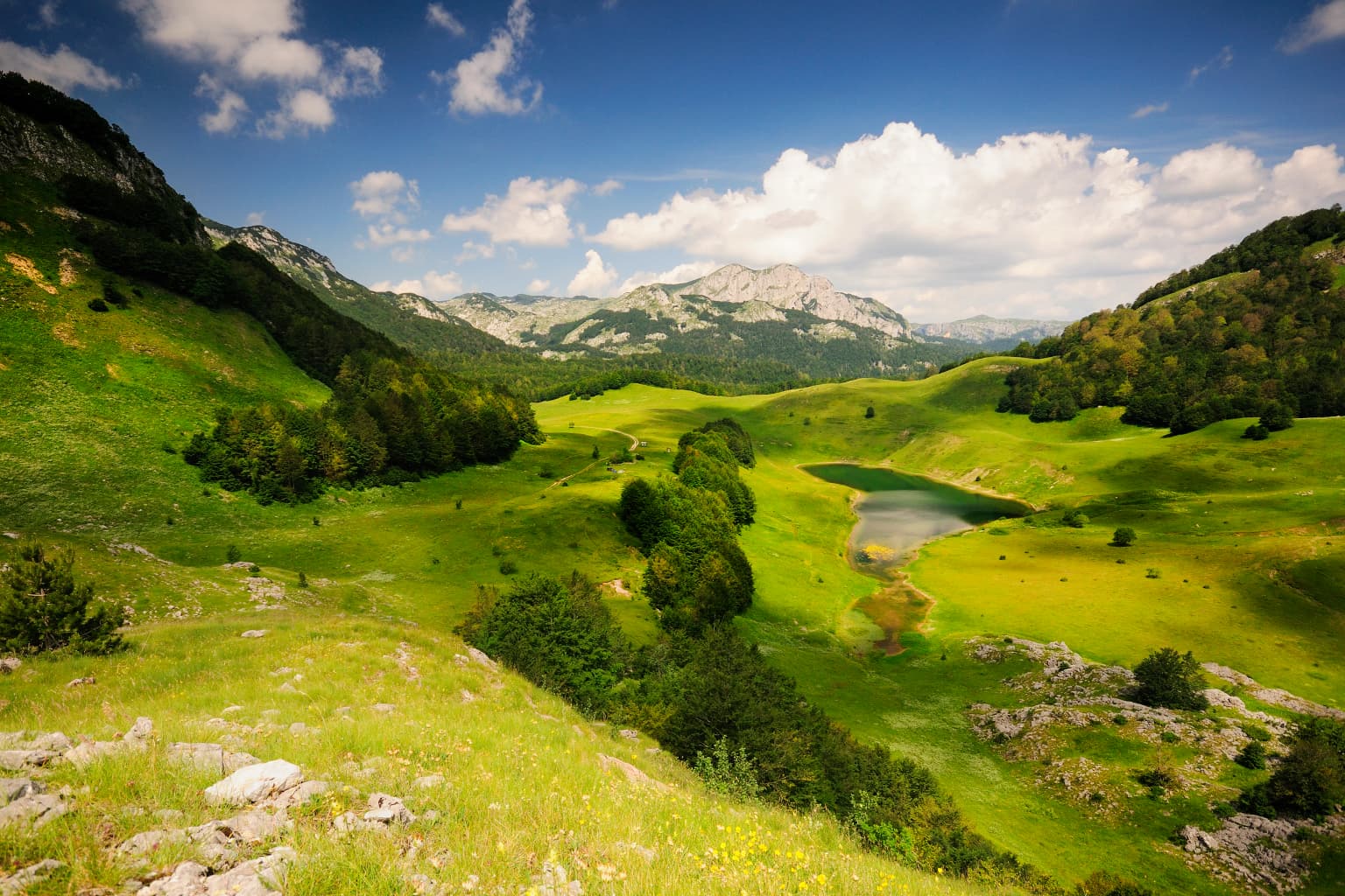
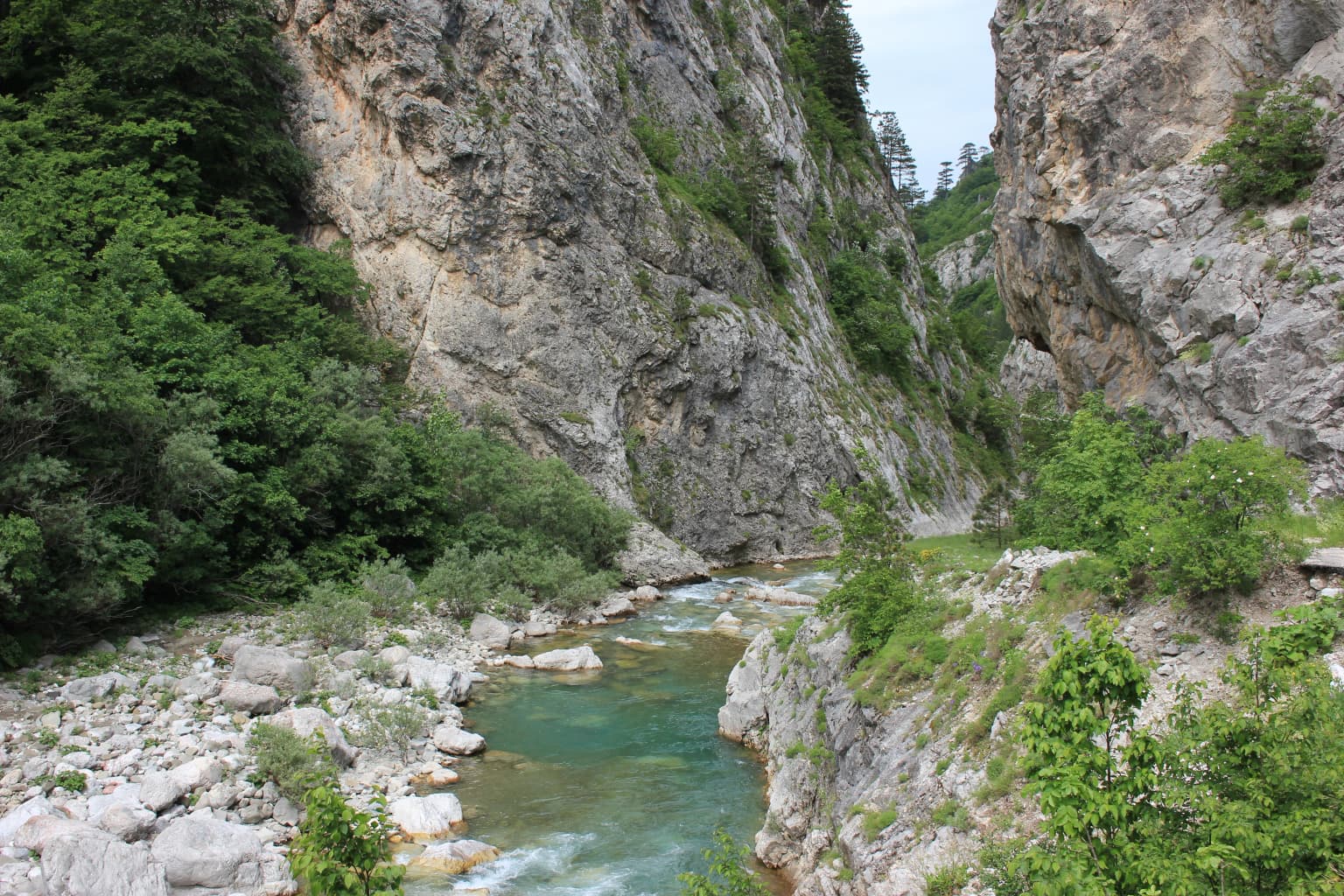
The physical landscape of Sutjeska National Park presents a dramatic interplay of high mountain ridges, deep river valleys, and ancient forests. The park is framed by a circle of peaks exceeding 2,000 meters, with Maglić at 2,386 meters standing as the highest point in Bosnia and Herzegovina, its slopes shared with Montenegro. The Sutjeska River has carved an impressive canyon reaching 1,200 meters deep through the center of the park, dividing the Zelengora massif from the Maglić-Volujak-Bioč mountain group. The terrain is characterized by steep, rocky slopes in the upper elevations giving way to forested slopes below, with the Perućica valley representing a particularly dramatic contrast between sheer limestone walls and the lush green of the primeval forest. Zelengora mountain supports a distinctive landscape of nine glacial lakes scattered across its forests and grassy plateaus, locally called the "Eyes of the Mountain." The park's hydrology is dominated by the Piva and Drina rivers forming the northwestern boundary, while the Sutjeska and its numerous tributaries drain the interior valleys.

A panoramic view of dense green forests and mountain ranges with a waterfall visible in the valley below, framed by pine trees in the foreground.
Panoramic view of dense forests and mountain ranges in Sutjeska National Park, with Skakavac waterfall visible in the valley below.

Sutjeska National Park ecosystems, habitats, and plant life

The ecological character of Sutjeska National Park is defined by its diverse forest communities and the presence of one of Europe's last remaining primeval forests. Approximately 66 percent of the park is covered in forest, with the remainder composed of mountain pastures, meadows, and rocky terrain above the tree line. The vegetation follows a clear altitudinal zonation, with thick coniferous and beech forests covering northwestern slopes up to 1,600 meters, while other areas present steeper, more barren rocky terrain. Perućica represents the ecological heart of the park—a Strict Nature Reserve where the forest has never been logged, featuring massive beech trees reaching 60 meters in height and girths of 150 centimeters, interspersed with endemic black pines anchored in the rocky cliff faces. The park's botanical diversity includes approximately 2,600 species of vascular plants, many rare or endemic to the region, along with roughly 100 species of edible fungi. The nine glacial lakes of Zelengora add aquatic and wetland habitats to the ecosystem, creating a complex mosaic of terrestrial and freshwater environments.

Rocky mountain peaks with a valley below, under a partly cloudy sky during sunset
Sunset view of Maglic Mountain peak, the highest point in Sutjeska National Park

Sutjeska National Park wildlife and species highlights

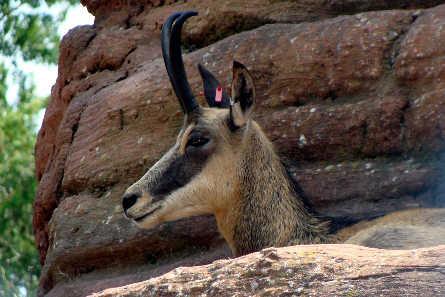
The wildlife population of Sutjeska National Park is diverse and significant for the Balkans. The larger mammals include bear, wolf, boar, wild cat, and fox, with the park's mountainous terrain providing ideal habitat for chamois and wild goats. The Balkan chamois (Rupicapra rupicapra balcanica), a distinctive goat-antelope subspecies, has been particularly successful in the park, with 256 individuals transplanted to 13 other areas of Bosnia and Herzegovina and Croatia between 1963 and 1987. The park supports more than 300 bird species, particularly in the lake-rich Zelengora area and wetland zones. Notable avian residents include golden eagle, grouse, peregrine falcon, blackbird, and rock partridge. The primeval forest of Perućica provides critical habitat for many of these species, with the Bosnian source noting nine species of woodpecker representing 90 percent of the European woodpecker family.

Waterfall flowing down a rocky cliff with green vegetation on both sides and a stream below
Skakavac waterfall cascading through rocky cliffs in Sutjeska National Park

Sutjeska National Park conservation status and protection priorities

Sutjeska National Park serves as a flagship protected area for Bosnia and Herzegovina and participates in international conservation networks through its affiliation with the EUROPARC Federation. The park faces ongoing challenges from resource exploitation, including illegal firewood extraction, prompting significant conservation intervention. The World Bank has supported a major multipurpose management plan focusing on biodiversity conservation, sustainable forestry, cultural heritage preservation, tourism development, and socioeconomic advancement. This project, funded with US$2.76 million including contributions from the Global Environment Facility, began in 2006 and encompasses both Sutjeska and Kozara National Parks. Future expansion plans would add more than 8,000 hectares to the park, potentially making it the largest protected area in the Republic of Srpska. A transboundary initiative with Montenegro aims to create a unified protected zone connecting Sutjeska with Durmitor National Park, preserving the shared Maglić-Volujak-Bioč mountain ecosystem and including the scenic Trnovačko Lake.

Sutjeska National Park cultural meaning and human context

Sutjeska National Park carries deep historical significance beyond its natural values, rooted in the events of World War II. The Battle of the Sutjeska, also known as the Fifth Enemy Offensive, took place from May 15 to June 16, 1943, when German forces attempted to encircle and destroy Yugoslav Partisan units operating in the mountains of eastern Bosnia. Despite being outnumbered and facing coordinated attacks, the Partisans under the Supreme Headquarters led by Marshal Josip Broz Tito successfully broke through the encirclement, though at significant cost with approximately one-third of their forces lost. The Tjentište valley at the northern edge of the park became the site of memorial construction, with the Memorial Complex built between 1958 and 1975 containing a monument by sculptor Miodrag Živković, an ossuary holding the remains of 3,301 fighters, and a museum dedicated to the battle. The park also hosts the annual OK Fest youth festival, originally conceived as a Friendship Camp and now a prominent event promoting youth and eco-tourism.

A chamois with curved horns and a brown and white coat resting against a rocky cliff face
Chamois resting near rocky terrain in a mountainous environment

Top sights and standout views in Sutjeska National Park

Sutjeska National Park combines exceptional natural treasures with profound historical resonance. The primeval forest of Perućica stands as one of Europe's last untouched forests, a Strict Nature Reserve featuring 300-year-old trees and the spectacular Skakavac waterfall cascading 75 meters through ancient beech and pine. Maglić Mountain at 2,386 meters represents both the highest peak in Bosnia and Herzegovina and a challenging ascent for experienced hikers. The nine glacial lakes of Zelengora, known as the "Eyes of the Mountain," form a rare alpine lake system unique in the Balkans. The park's historical layer includes the memorial complex at Tjentište commemorating the Battle of the Sutjeska and Partisan resistance during World War II. The Tara River flowing along the park's boundary offers white-water rafting opportunities, while the network of mountain huts on Zelengora provides access for hikers exploring this remote landscape.

A river with turquoise water flows through a narrow canyon flanked by steep rocky cliffs covered in green vegetation
Sutjeska River flowing through a rocky canyon with lush green vegetation

Best time to visit Sutjeska National Park

The park is accessible throughout most of the year, though winter conditions bring restrictions to some areas due to snow and cold temperatures. The summer months of June through September offer the most reliable access and the warmest conditions for hiking, particularly in the higher elevations. Spring and early summer bring abundant wildflower displays in the mountain meadows and the clearest flow for the park's waterfalls, including the dramatic Skakavac. Autumn provides another excellent season with golden foliage in the forests and fewer visitors. The transitional seasons of spring and autumn may offer the most rewarding combination of accessible trails and scenic variety, though visitors should be prepared for variable mountain weather regardless of season.

Park location guide

Geography guide, regional context, and park location map for Sutjeska National Park

Sutjeska National Park park geography, regions, and map view in Bosnia and Herzegovina
Understand where Sutjeska National Park sits in Bosnia and Herzegovina through a broader geographic reading of the surrounding landscape, nearby location context, and its mapped position within the national park landscape.

How Sutjeska National Park fits into Bosnia and Herzegovina

Bosnia and Herzegovina is a federal parliamentary republic in Southeast Europe on the Balkan Peninsula. It borders Serbia, Montenegro, and Croatia, with a 20-kilometre coastline on the Adriatic Sea. The country has a population of approximately 2.9 million and features diverse geography ranging from mountainous Dinaric Alps in the north to Mediterranean climate in the southern Herzegovina region. Sarajevo serves as the capital and largest city.

Wider geography shaping Sutjeska National Park in Bosnia and Herzegovina

Bosnia and Herzegovina occupies the central and eastern parts of the Balkan Peninsula. The country is largely mountainous, dominated by the Dinaric Alps in the central and eastern regions. Bosnia occupies the northern and central areas, while Herzegovina covers the southern region. The country has a small coastline along the Adriatic Sea, approximately 20 kilometres long, near the town of Neum.

Map view of Sutjeska National Park

Use this park location map to pinpoint Sutjeska National Park in Bosnia and Herzegovina, understand its exact geographic position, and read its mapped placement within the surrounding landscape more clearly.

Pigeon | © OpenStreetMap contributors

Location context for Sutjeska National Park

Republika Srpska

Visualizing Bosnia's Oldest Protected Area: Glacial Lakes, Deep River Canyons, and Ancient Forest Habitats

Sutjeska National Park Photos: Explore Dramatic Mountain Landscapes and Primeval Forest Scenery
Visually explore Sutjeska National Park's stunning landscapes, featuring the rugged terrain of Maglić Mountain, the ancient Perućica primeval forest, and the pristine glacial lakes of Zelengora. These park images provide essential visual context for understanding the unique ecosystems, dramatic scenery, and the overall protected-area character of Bosnia and Herzegovina's oldest national park.

Mountain valley with green meadows, a small lake, and distant peaks under a blue sky with scattered clouds

Sunset over Orlovacko Lake with green meadows and mountain peaks in the background

A panoramic view of dense green forests and mountain ranges with a waterfall visible in the valley below, framed by pine trees in the foreground.

Rocky mountain peaks with a valley below, under a partly cloudy sky during sunset

Waterfall flowing down a rocky cliff with green vegetation on both sides and a stream below

Mountainous landscape with green hills, forest trees in foreground, and blue sky with white clouds

A chamois with curved horns and a brown and white coat resting against a rocky cliff face

A river with turquoise water flows through a narrow canyon flanked by steep rocky cliffs covered in green vegetation

Trnovačko Lake with Maglić Mountain in background, surrounded by green meadows and forested hills under blue sky with white clouds

Park atlas

Trace the wider mountain landscapes and primeval forests surrounding Sutjeska National Park, comparing protected areas across the Balkans region.

Discover Other National Parks Near Sutjeska National Park, Exploring Surrounding Balkans Protected Areas
After exploring Sutjeska National Park, browse other national parks and protected areas in the nearby Balkans, discovering diverse mountain peaks, glacial lakes, and ancient forests across Bosnia and Herzegovina and Montenegro. Comparing these conservation landscapes provides a richer geographic context for the region's significant natural heritage and conservation efforts.
National park

Tara National Park: Endemic Flora and Dramatic Dinaric Alps Geography

Discover Serbia's iconic protected mountain landscape and its unique botanical heritage.

Tara National Park is a significant protected area in Serbia, celebrated for its exceptional botanical value and dramatic mountainous terrain. It is the last refuge for Pančić's spruce, a living fossil conifer, and hosts a remarkable diversity of Balkan flora. The park's landscape is defined by steep limestone cliffs, deep river valleys like the Drina canyon, and expansive forest ecosystems, offering a unique geographic study of protected lands. Explore its mapped features and discover a vital conservation area within the Dinaric Alps.

Area
249.92 km²
Established
1981
Relief
Mountain
Climate
Temperate
Watercolor illustration showing rolling hills, a river, trees, and distant mountains
Protected landscape

Zlatibor Protected Landscape: Explore its Mapped Geography and Unique Alpine Meadows

Discover Dinaric Alps protected terrain and landscape context.

Zlatibor Protected Landscape offers a distinct exploration of mountainous terrain and protected natural areas in Serbia. Situated in the Dinaric Alps, its landscape is defined by rolling upland plateaus, dense coniferous forests, and open alpine meadows, creating a visually rich environment. The park's geography includes notable karst features and extensive cave systems, complemented by the natural boundaries of significant rivers. Delve into the mapped protected area to understand its landscape character, from the highest peak at Tornik to the unique geological formations and the rare endemic pine subspecies, providing a concrete geographic perspective for atlas-based discovery.

Area
0.419 km²
Established
2017
IUCN
VI
Relief
Mixed relief
Watercolor painting showing a river canyon with mountains in the background and green vegetation in the foreground
National park

Drina National Park: Bosnia and Herzegovina's Protected Canyon and Endemic Ecosystem

Explore mapped geography and natural landscapes in this Balkan national park.

Drina National Park is a protected area in eastern Bosnia and Herzegovina, celebrated for its striking Drina River canyon landscape. As a national park, it preserves vital habitats for endemic species such as the Serbian spruce and provides a crucial geographic anchor for regional conservation. Its deep gorges and steep slopes offer a rich context for understanding the natural terrain and mapped boundaries within the broader Balkan geography.

Area
63.15 km²
Established
2017
IUCN
II
Relief
Mountain
National park

Mljet National Park: Protected Karst Terrain and Unique Marine Lakes in Croatia

Explore mapped park boundaries and Mediterranean island geography.

Mljet National Park represents a significant protected landscape within the Adriatic Sea, celebrated for its distinctive karst terrain and the extraordinary phenomenon of its saltwater lakes, Veliko and Malo jezero. This national park showcases some of the most intact Mediterranean forests in the region, offering a unique geographic profile for atlas-based discovery. Examine the park's protected status and its relationship to the surrounding island and marine geography.

Area
53 km²
Established
1960
Relief
Lowland
Climate
Mediterranean
Watercolor illustration of a landscape with green hills, a river, and distant mountains under a light sky
Protected landscapeDalmatia

Biokovo Nature Park: Protected Landscape and Karst Terrain in Dalmatia

Explore Dalmatia's premier protected mountain range along the Adriatic.

Biokovo Nature Park is a striking protected landscape situated in the Dalmatia region of Croatia, characterized by its immense limestone massifs that create a formidable barrier between the coast and the continental interior. This protected area is defined by its classic karst topography, featuring a complex network of sinkholes and caves, and offers unparalleled views from peaks like Sveti Jure. MoriAtlas provides detailed geographic context for understanding Biokovo Nature Park's unique terrain, mapped boundaries, and its significant role in the regional landscape.

Area
196 km²
Established
1981
Relief
Mountain
Climate
Mediterranean
Watercolor painting showing a mountainous landscape with a lake, green hills, and pink flowers
National park

Alps of Albania National Park: Explore Albania's Largest Protected Alpine Wilderness

Dramatic karst, glacial valleys, and high-altitude ecosystems await.

The Alps of Albania National Park offers an expansive view into one of the Balkans' most significant mountain protected areas. This national park encompasses a spectacular landscape characterized by towering limestone peaks, deep glacial valleys carved over millennia, and intricate karst formations like Grunas Canyon. Its pristine wilderness protects diverse high-altitude ecosystems and unique geological features, serving as a key destination for understanding regional geography and protected landscapes.

Area
828.447 km²
Established
2022
IUCN
II
Relief
Mountain
National parkKosovo

Bjeshkët e Nemuna National Park: Kosovo's Largest Alpine Protected Landscape

Explore dramatic mountains, glacial lakes, and diverse ecosystems.

Delve into the protected geography of Bjeshkët e Nemuna National Park, Kosovo's expansive national park located in the Accursed Mountains. This atlas entry details its significant alpine terrain, from dense forests to high-altitude meadows, and highlights the presence of glacial lakes like Liqenat. Understand its role as a vital conservation corridor and a key component of the Balkan's natural heritage.

Area
630.28 km²
Established
2012
IUCN
II
Watercolor illustration of rolling hills, green vegetation, and distant mountains under a light sky
Protected area

Lastovo Nature Park: Discover the Adriatic Karst Archipelago's Protected Landscape

Mapped karst terrain, ancient architecture, and natural island geography.

Lastovo Nature Park protects a remote Croatian archipelago characterized by its striking karst landscape, featuring 46 hills and 46 karstic fields. This protected area offers significant natural biodiversity and remarkably preserved cultural heritage, with extensive Holm Oak and Aleppo Pine forests covering over 60% of the island. Explore Lastovo's unique geography, mapped terrain, and its distinct place within the Adriatic region.

Area
46.87 km²
Established
2006
Relief
Upland
Climate
Mediterranean

Common questions about visiting, size, designation, and location context for Sutjeska National Park

Sutjeska National Park FAQs for park facts, access, geography, and protected area context
Find quick answers about Sutjeska National Park, including protected-area facts, park geography, trail and visitor context, and how the park fits into its surrounding country and regional landscape.
MoriAtlas Explorer

Continue Your Protected Areas Search Across the Global Atlas

Deepen your exploration by continuing the structured search for national parks and protected areas worldwide. Utilize the comprehensive filtering capabilities to compare different conservation landscapes and refine your understanding of global park geography. Discover more about the distribution and characteristics of protected natural areas.

Global natural geography