Mori Atlas logo
National parkTawau Hills National Park

Understand the geographic boundaries and natural terrain of this national park in Malaysia.

Tawau Hills National Park: Exploring Protected Landscape and Regional Geography in Sabah

Tawau Hills National Park stands as a significant protected area within the diverse geography of Sabah, Malaysia. This page details its protected landscape identity, offering insights into its mapped boundaries and regional context. Delve into the natural terrain that defines this national park, providing essential data for geographic discovery and atlas exploration.

lowland dipterocarp rainforestvolcanic landscapeswaterfall destinationshot springsBorneo nature reservesSabah national parks

Tawau Hills National Park

National park

Park overview

Structured park overview, official facts, and landscape profile for Tawau Hills National Park

Tawau Hills National Park park facts, protected area profile, and essential visitor context
Review the core facts for Tawau Hills National Park, including designation, size, terrain, visitor scale, habitats, and operating context in one park-focused overview.

About Tawau Hills National Park

Tawau Hills National Park occupies a distinctive position in Sabah's protected area network as the primary conservation landscape in the state's eastern lowland region. The park's establishment in 1979 reflected growing recognition in Malaysia during the 1970s of the need to protect water catchment areas and preserve remaining forest cover in regions experiencing agricultural expansion. The park's location in the Tawau district places it within a landscape that has undergone extensive conversion for oil palm and cacao cultivation, making the protected forest area increasingly important as a reference site for lowland dipterocarp forest ecosystem structure and function. The volcanic geology underlying the park creates varied terrain including hills, valleys, and rocky outcrops that support diverse habitat conditions. Visitor infrastructure including picnic areas, camping grounds, and chalet accommodations allows for day visits and overnight stays, making the park accessible for both quick excursions and extended nature experiences. The hot springs represent a unique geological feature within the park, offering visitors the opportunity to experience natural thermal waters in a forest setting.

Quick facts and research context for Tawau Hills National Park

Tawau Hills National Park is located in Tawau district, Sabah, Malaysia, on the island of Borneo. The park spans roughly 280 square kilometers of protected lowland dipterocarp rainforest and volcanic terrain. Established in 1979, it serves as a critical water catchment area for Tawau town. The highest peak is Gunung Magdalena at 1,310 meters above sea level. The park features hot springs, multiple waterfalls including the notable Table Waterfall, and visitor facilities including picnic areas, camping sites, and chalets. It is administered by Sabah Parks, the state-level protected area management authority.

Park context

Deeper park guide and search-rich context for Tawau Hills National Park

Tawau Hills National Park history, landscape, wildlife, and travel context
Explore Tawau Hills National Park through its history, landscape character, ecosystems, wildlife, conservation priorities, cultural context, and seasonal travel timing in a structured park guide built for atlas discovery and search intent.

Why Tawau Hills National Park stands out

Tawau Hills National Park is best known for its volcanic landscape character and accessible waterfall destinations within Sabah's eastern region. The park contains rugged volcanic terrain resulting from ancient volcanic activity in the Semporna Peninsula region, with natural hot springs that remain a visitor attraction. The Table Waterfall represents one of the park's signature natural features, dropping in distinct terraced tiers that have become a popular destination for day visitors. The protection of lowland dipterocarp rainforest in an area otherwise heavily converted to oil palm and cacao plantations gives the park additional ecological significance as a remaining tract of unmodified forest in a heavily agricultural landscape.

Tawau Hills National Park history and protected-area timeline

Tawau Hills National Park was established in 1979 through the Sabah state government's protected area creation program managed by Sabah Parks. The primary motivation for the park's designation was water catchment protection for Tawau town, reflecting the park's hydrological significance in supplying the settlement's water needs. The park was created during a period when Sabah was rapidly expanding its protected area network following earlier establishment of parks such as Kinabalu Park in the 1960s. The selection of this area for protection also acknowledged the remaining forest cover in the Tawau region, which had already experienced significant deforestation for agricultural development. The governance of the park falls under Sabah Parks, the state statutory body responsible for managing Sabah's national parks and nature reserves, ensuring consistent management standards and visitor services.

Tawau Hills National Park landscape and geographic character

The landscape of Tawau Hills National Park is characterized by rugged volcanic terrain formed from ancient volcanic activity in the Semporna Peninsula region of eastern Sabah. The park contains several prominent hills and ridges, with the highest point being Gunung Magdalena at 1,310 meters above sea level. The terrain includes steep-sided valleys and rocky outcrops that create visual diversity and varied microhabitats within the forest. The volcanic geology contributes to the presence of natural hot springs, where geothermally heated groundwater emerges at the surface, creating a distinctive attraction within the park's forest environment. The park's water features include several waterfalls, with Table Waterfall being the most prominent, characterized by its tiered structure and accessible location within the park's visitor area. The surrounding landscape outside the park boundaries has been extensively modified for oil palm and cacao plantations, creating a sharp contrast between the protected forest and the agricultural lowlands.

Tawau Hills National Park ecosystems, habitats, and plant life

Tawau Hills National Park protects an important tract of lowland dipterocarp rainforest in eastern Sabah, an ecosystem type that has been extensively cleared across much of lowland Borneo. The dipterocarp forest dominates the park's vegetation, characterized by the family Dipterocarpaceae trees that form the dominant canopy in lowland tropical rainforests across Southeast Asia. The park's elevation range from valley floors to 1,310 meters at Gunung Magdalena supports transitions between different forest types, though the park remains predominantly in the lowland elevation zone. The surrounding area outside the park boundaries has been largely converted to agricultural plantations, making the protected forest area a critical refuge for forest-dependent species and an important remnant of unmodified lowland forest in the region.

Tawau Hills National Park wildlife and species highlights

The park's protected lowland dipterocarp forest provides habitat for forest-dwelling species typical of Bornean lowland rainforests. While the source material provides limited specific wildlife detail, the forest ecosystem supports diverse fauna including birds, mammals, and insects associated with intact lowland forest environments. The remaining forest cover and protected status of the area make it significant for conservation of species that require forest habitats, particularly in a landscape where surrounding areas have been heavily modified for agriculture.

Tawau Hills National Park conservation status and protection priorities

Tawau Hills National Park plays an important conservation role in eastern Sabah as a protected area preserving lowland dipterocarp forest in a region where agricultural expansion has dramatically reduced natural forest cover. The park's designation as a Category II protected area under the IUCN protected area classification reflects its national park status and primary focus on ecosystem conservation and protection. Beyond biodiversity conservation, the park serves the critical function of protecting the water catchment area for Tawau town, linking environmental protection with essential water resource management for the regional population. The surrounding landscape dominated by oil palm and cacao plantations emphasizes the conservation value of the remaining protected forest area, which serves as a reference site for lowland forest ecosystem structure and provides connectivity benefits for wildlife in the fragmented agricultural landscape.

Top sights and standout views in Tawau Hills National Park

Tawau Hills National Park offers visitors access to volcanic landscapes, natural hot springs, and accessible waterfalls within a protected forest setting in eastern Sabah. The Table Waterfall stands as the park's signature natural attraction, featuring dramatic drops in a tiered configuration that draws day visitors. The natural hot springs provide a unique opportunity to experience geothermal activity within a tropical rainforest environment. The park's elevation peak at Gunung Magdalena at 1,310 meters offers potential for hikers seeking higher ground within the protected area. Visitor facilities including picnic areas, camping sites, and chalets make the park accessible for both short visits and overnight nature experiences.

Best time to visit Tawau Hills National Park

The park can be visited throughout the year given its location in the tropical climate of eastern Sabah. The wetter months from October to February typically bring higher rainfall, which can affect trail conditions and visibility but may also enhance waterfall flow rates. The drier period from March to September generally offers more consistent weather for outdoor activities, though visitors should be prepared for tropical heat and humidity year-round. The hot springs remain accessible in all seasons, though the contrast between cool forest air and warm spring water may be more comfortable during cooler dry season months.

Park location guide

Geography guide, regional context, and park location map for Tawau Hills National Park

Tawau Hills National Park park geography, regions, and map view in Malaysia
Understand where Tawau Hills National Park sits in Malaysia through a broader geographic reading of the surrounding landscape, nearby location context, and its mapped position within the national park landscape.

How Tawau Hills National Park fits into Malaysia

Malaysia is a federal constitutional monarchy located in Southeast Asia. The country consists of 13 states and three federal territories, divided by the South China Sea into Peninsular Malaysia on the Indochinese Peninsula and East Malaysia on the island of Borneo. With a population of over 34 million, it achieved independence from Britain in 1957 and became a modern federation in 1963. The country is recognized for its multicultural population, tropical climate, and significant economic role in the region.

Wider geography shaping Tawau Hills National Park in Malaysia

Malaysia occupies a strategic position in Southeast Asia, split by the South China Sea into two distinct regions. Peninsular Malaysia lies on the Indochinese Peninsula, sharing a land border with Thailand to the north and maritime borders with Singapore, Vietnam, and Indonesia. East Malaysia occupies the northern portion of Borneo, sharing land borders with Brunei and Indonesia, and maritime borders with the Philippines and Vietnam. The country's terrain includes coastal plains, mountain ranges such as the Titiwangsa in the peninsula, and extensive tropical rainforests.

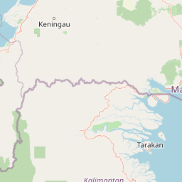
Map view of Tawau Hills National Park

Use this park location map to pinpoint Tawau Hills National Park in Malaysia, understand its exact geographic position, and read its mapped placement within the surrounding landscape more clearly.

Pigeon | © OpenStreetMap contributors

Location context for Tawau Hills National Park

Sabah
Park atlas

Trace protected landscapes and volcanic terrain across Borneo, comparing national parks adjacent to Tawau Hills.

Discover National Parks Near Tawau Hills: Explore Sabah's Protected Areas and Regional Geography
Continue your exploration from Tawau Hills National Park by browsing other national parks and protected areas mapped across Sabah and the broader Borneo region, examining their unique conservation landscapes. Compare varied park geography, from lowland dipterocarp rainforests to distinct volcanic features, to gain regional context for protected area distribution and ecological significance.
National parkSabah

Tun Sakaran Marine Park National Park: Sabah Marine Archipelago Atlas

Explore the islands, sand cays, and coral reef geography.

Tun Sakaran Marine Park is a protected national park in Sabah, Malaysia, known for its stunning marine biodiversity and archipelago landscape. This atlas entry details the park's distinct islands, dynamic sand cays, and extensive coral reef systems within the Celebes Sea, offering insights into its unique geographic setting and ecological significance.

Area
101 km²
Established
2004
IUCN
II
Relief
Lowland
National parkMalaysia

Crocker Range National Park: A Protected Landscape within Malaysia's Borneo Region

Mapped boundaries and regional geography context for exploration.

Crocker Range National Park represents a significant protected area within Malaysia, contributing distinct geographic features and landscape context to the Borneo region. This detailed view supports atlas exploration by outlining the park's mapped boundaries and its role within the nation's protected lands. Understand the park's specific location and geographic identity, enriching your comprehension of Malaysian natural landscapes and conservation areas.

Area
1,399 km²
Established
1984
IUCN
II
Relief
Mountain
National parkSabah

Tunku Abdul Rahman National Park: Sabah National Park Protected Landscape & Geography

Explore mapped boundaries and regional context.

Tunku Abdul Rahman National Park, designated as a national park, offers a specific focus on protected landscape exploration within Sabah. This entity details its geographic footprint and its significance as a mapped natural area. Understanding its role within the regional geography allows for a more complete exploration of Malaysia's protected lands through an atlas perspective.

Area
49 km²
Established
1974
IUCN
II
Relief
Mixed relief
National parkNorth Kalimantan

Kayan Mentarang National Park: A Protected Landscape in North Kalimantan

Explore Borneo's critical protected area and its vast forest geography.

Kayan Mentarang National Park is an immense protected area in North Kalimantan, Indonesia, renowned for being a crucial part of the Heart of Borneo conservation initiative. This national park encompasses over 13,600 square kilometers of primary tropical rainforest, sheltering diverse montane and lowland habitats along the Indonesia-Malaysia border. Its importance lies in its vast, contiguous landscape, critical role in regional biodiversity, and its representation of one of Southeast Asia's last great wilderness expanses, offering significant insight into mapped protected areas.

Area
13,605 km²
Established
1996
IUCN
II
Scope
Mixed
National parkBrunei

Ulu Temburong National Park: Brunei's Protected Rainforest Landscape and Geographic Context

Mapped natural terrain and conservation significance.

Ulu Temburong National Park represents Brunei's commitment to preserving its most ecologically significant tropical rainforests, covering approximately 550 square kilometers. This protected area is characterized by its remote location in the Temburong District and its diverse topography, ranging from lowland areas to mountainous ridges, all within a largely undisturbed natural setting. The park's mapped boundaries encompass a vital transboundary conservation landscape, making it a key site for understanding Borneo's unique ecosystems and forest protection policies through an atlas-driven exploration approach.

Area
488.59 km²
Established
1991
IUCN
II
Relief
Mixed relief
National parkLimbang Division

Pulong Tau National Park: A Protected National Park in Malaysia's Limbang Division

Explore its mapped boundaries and regional landscape context.

Pulong Tau National Park represents a key protected area within the Limbang Division, offering valuable geographic and atlas-based discovery opportunities. This page details the park's identity as a national park, focusing on its mapped boundaries and its role within the protected landscapes of Malaysia. Users can explore the park's specific geographic characteristics and understand its context within the regional atlas, providing a factual foundation for appreciating its natural landscape value.

Area
665.25 km²
Established
1998
IUCN
II
Relief
Mountain
Nature reserveTemburong District

Peradayan Forest Reserve Nature Reserve: Understanding its Protected Landscape and Geographic Setting

Explore mapped boundaries and the natural terrain of this Brunei reserve.

Peradayan Forest Reserve stands as a significant protected natural area within Brunei's Temburong District, an exclave characterized by vast tropical rainforests. This entry focuses on its identity as a nature reserve, providing key geographic context and details about its mapped boundaries. Understand its role within the regional landscape and how its protected status contributes to the conservation of Brunei's natural heritage, facilitating a deeper dive into atlas-style geographic exploration.

Area
26.5 km²
Relief
Upland
Climate
Tropical
Access
Moderate access
National parkSarawak

Gunung Buda National Park: Sarawak National Park Protected Landscape and Geography

Explore the mapped boundaries and regional context of this Malaysian national park.

Gunung Buda National Park is a significant protected area within Sarawak, Malaysia, contributing to the region's diverse geography. As a national park, it offers specific insights into mapped protected lands, providing a focal point for understanding Borneo's natural landscapes. This entry details its geographic identity and its role as a protected natural space, crucial for any atlas-driven exploration of East Malaysia's conservation areas.

Area
66.2 km²
Established
2001
IUCN
II
Relief
Mountain

Common questions about visiting, size, designation, and location context for Tawau Hills National Park

Tawau Hills National Park FAQs for park facts, access, geography, and protected area context
Find quick answers about Tawau Hills National Park, including protected-area facts, park geography, trail and visitor context, and how the park fits into its surrounding country and regional landscape.
MoriAtlas Explorer

Continue Your Protected Areas Search Across the Global Atlas

Deepen your exploration by continuing the structured search for national parks and protected areas worldwide. Utilize the comprehensive filtering capabilities to compare different conservation landscapes and refine your understanding of global park geography. Discover more about the distribution and characteristics of protected natural areas.

Global natural geography