Mori Atlas logo
National parkTel Hazor National Park

Discover the mapped boundaries and regional landscape character of this Israeli national park.

Tel Hazor National Park: Protected Landscape Geography and Atlas Context in Israel

Tel Hazor National Park represents a key protected area within Israel's diverse geography, offering a distinct national park identity for atlas exploration. This page details the park's geographic scope, providing insights into its landscape context and mapped protected boundaries. Understand how Tel Hazor National Park fits into the regional natural landscape and contributes to the structured discovery of protected lands across the Middle East.

archaeological siteUNESCO World Heritage Siteancient citybiblical archaeologyBronze AgeIron Age

Tel Hazor National Park

National park

Park overview

Structured park overview, official facts, and landscape profile for Tel Hazor National Park

Tel Hazor National Park park facts, protected area profile, and essential visitor context

Review the core facts for Tel Hazor National Park, including designation, size, terrain, visitor scale, habitats, and operating context in one park-focused overview.

About Tel Hazor National Park

Tel Hazor represents one of the most significant archaeological sites in Israel and the broader ancient Near East. The tell rises approximately 40 meters above the surrounding landscape and contains over three millennia of continuous settlement history spanning from the Early Bronze Age through the Hellenistic period. As the largest fortified city in the region during its peak, Hazor controlled vital trade routes connecting Mesopotamia, Egypt, and the Mediterranean coast. The city's importance is evidenced by its mention in Egyptian execration texts, the Amarna correspondence, and the Mari archive, making it one of the most documented Bronze Age cities outside Egypt and Mesopotamia.

The excavation history of Tel Hazor spans nearly a century, beginning with preliminary soundings by John Garstang in 1926 and continuing through multiple major campaigns. The groundbreaking excavations led by Yigael Yadin in the 1950s established many of the foundational interpretations of the site and produced a landmark five-volume publication series. Since 1990, work has resumed under the direction of Amnon Ben-Tor of Hebrew University in collaboration with the Complutense University of Madrid, with ongoing excavations revealing new insights into the city's complex history.

Quick facts and research context for Tel Hazor National Park

Tel Hazor is the largest archaeological site in northern Israel, with excavation work beginning in the 1920s and continuing to the present day. The most significant excavations were led by Yigael Yadin from 1955 to 1968, representing one of the most important archaeological undertakings in Israel's early statehood. The site has produced more cuneiform tablets than any other location in the Southern Levant, with texts in both Old Babylonian Akkadian and a local Late Bronze Age dialect. In 2005, Tel Hazor was designated a UNESCO World Heritage Site as part of the Biblical Tells, together with Megiddo and Beer Sheba.

Protection and recognition

Analyzing official conservation frameworks, designation history, and regional protection scope.

Tel Hazor National Park Protection Status and Protected Area Designation

National park explorers can trace the official conservation profile of Tel Hazor National Park, established in 2005 with a mixed protection scope. Accessing verified designation parameters and spatial management data provides clear geographic context for analyzing historic conservation zones.

Protection details

Protection scope
Mixed
Designated year
2005
Transboundary protection
No
Park context

Deeper park guide and search-rich context for Tel Hazor National Park

Tel Hazor National Park history, landscape, wildlife, and travel context

Explore Tel Hazor National Park through its history, landscape character, ecosystems, wildlife, conservation priorities, cultural context, and seasonal travel timing in a structured park guide built for atlas discovery and search intent.

Why Tel Hazor National Park stands out

Tel Hazor is best known for its extraordinary archaeological significance as one of the most powerful Canaanite city-states in ancient times. The site features well-preserved remains including a six-chambered gate from the Israelite period, administrative buildings, and a palace complex. Its cuneiform tablet collection is unparalleled in the region, providing crucial insights into Middle and Late Bronze Age diplomacy, trade, and law codes similar to Hammurabi's Code. The site also preserves evidence of violent destruction layers that some archaeologists correlate with biblical accounts of Joshua's conquest.
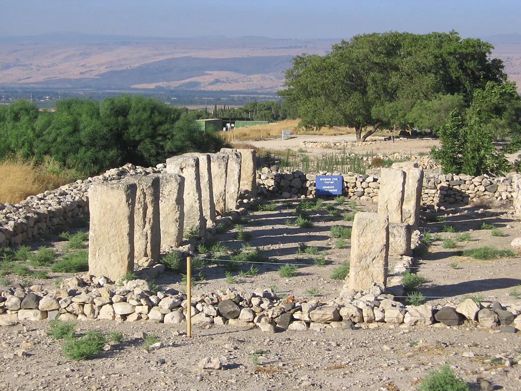
Archaeological ruins of the House of Pillars with standing stone columns at Tel Hazor National Park.
The House of Pillars archaeological ruins at Tel Hazor National Park.

Tel Hazor National Park history and protected-area timeline

The history of Tel Hazor spans from the Early Bronze Age II period around the 28th century BCE through successive periods of Canaanite, Egyptian, Israelite, and imperial control. The earliest significant settlement appeared in the Early Bronze Age III period, with evidence of a large monumental structure suggesting urban planning from an early stage. During the Middle Bronze Age II, Hazor served as a vassal state to the kingdom of Qatna and maintained strong Syrian cultural influence. A royal archive from this period includes correspondence with the rulers of Mari and Yamhad, documenting Hazor's role in extensive tin trade networks.

In the Late Bronze Age, Hazor became a major Canaanite city under Egyptian hegemony, appearing in the Amarna letters as a vassal kingdom. The biblical texts describe Hazor as the seat of King Jabin, who led a Canaanite coalition against Israelite forces. Archaeological evidence from the 13th century BCE reveals catastrophic destruction through fire, with debates ongoing among scholars about whether this aligns with biblical accounts of Joshua's conquest or represents other historical events such as internal civil strife or the broader Bronze Age collapse.

Following its destruction, Hazor was rebuilt as a smaller settlement within the territory of Naphtali and was subsequently fortified by Solomon in the 10th century BCE, alongside Megiddo and Gezer. The city experienced periods of Aramaean control and returned to Israelite jurisdiction before its final destruction by the Assyrian ruler Tiglath-Pileser III in 732 BCE, when the population was deported and the city burned.

Tel Hazor National Park landscape and geographic character

Tel Hazor occupies a strategic position on the Korazim Plateau in Upper Galilee, overlooking the Hula Valley to the north and the Sea of Galilee to the south. The tell consists of two distinct areas: a raised upper city covering approximately 12 hectares and a vast lower city extending over 70 hectares, making it the largest archaeological site in northern Israel. The upper mound rises about 40 meters above the surrounding terrain, providing commanding views across the fertile Galilean landscape. The site's position controlled important ancient trade routes connecting the coastal plains with the inland valleys and trans-Arabian trade networks.
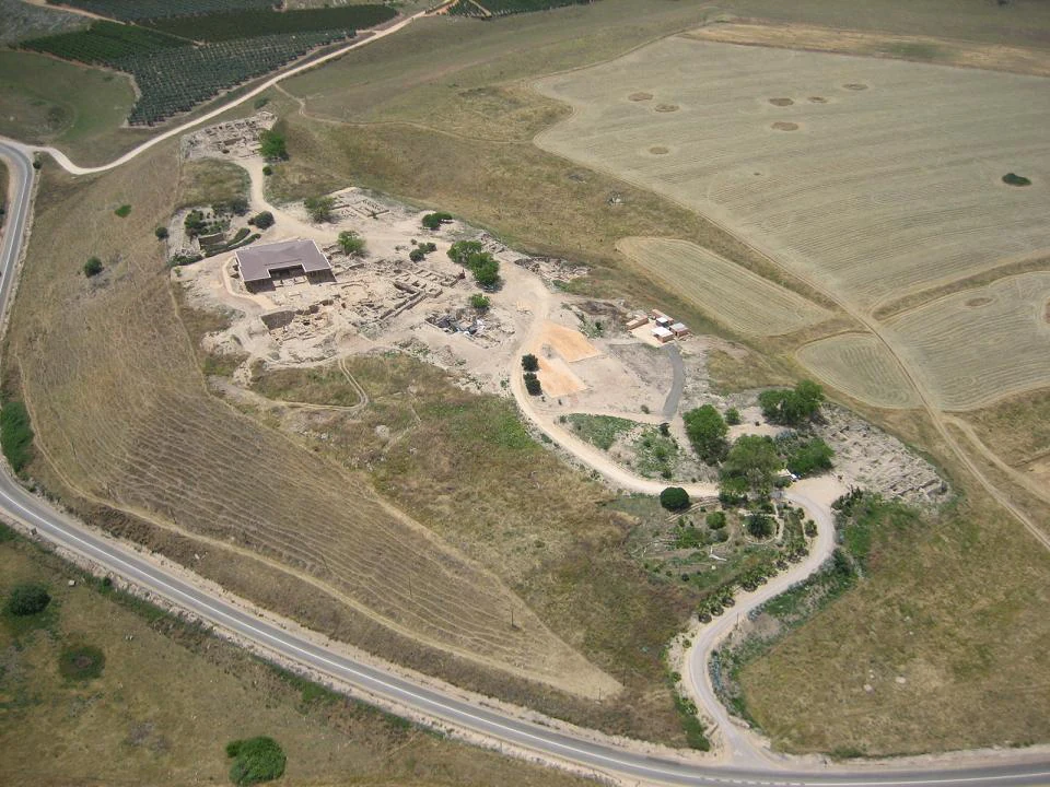
Aerial photograph of Tel Hazor National Park showing archaeological ruins, a building, roads, and surrounding agricultural fields
Aerial view of Tel Hazor National Park showing archaeological site and surrounding landscape

Tel Hazor National Park conservation status and protection priorities

Tel Hazor has been recognized as a UNESCO World Heritage Site since 2005 as part of the Biblical Tells, a transnational serial property including Megiddo and Beer Sheba. This designation reflects the site's outstanding universal value as a testimony to the urban civilization of the Bronze and Iron Ages in the Levant. Ongoing conservation efforts include excavation projects, site preservation, and the maintenance of structures exposed during decades of archaeological work. Artifacts recovered from the site are housed in a museum at Kibbutz Ayelet HaShahar, though some materials were damaged in a 2008 earthquake.

Tel Hazor National Park cultural meaning and human context

Tel Hazor holds profound significance for biblical archaeology and the study of ancient Israelite history. The site is explicitly mentioned in the Book of Joshua as "the head of all those kingdoms" and in the Book of Judges as the seat of King Jabin, whose commander Sisera led forces against the Israelite leader Barak. The narrative of Deborah and Sisera, preserved in both prose and poetic forms, references Hazor's Canaanite royal lineage. Archaeological discoveries, including a complex of cultic standing stones from Iron Age strata, have been interpreted as evidence of early Israelite presence and the emergence of conquest traditions. The site's extensive archive of cuneiform tablets provides crucial documentary evidence for understanding diplomatic, commercial, and legal practices in the ancient Near East.
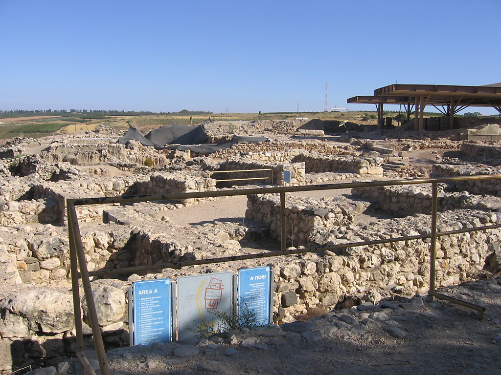
Ancient stone ruins of the Solomonic Gate at Tel Hazor National Park, with blue informational signs in the foreground and a modern shelter in the background
Ruins of the Solomonic Gate at Tel Hazor National Park with informational signs

Top sights and standout views in Tel Hazor National Park

The archaeological highlights of Tel Hazor include the monumental six-chambered gate from the Solomonic period, characteristic of Israelite city planning and similar to gates found at Megiddo and Gezer. The royal fortress gate and administrative palace complexes represent the peak of Canaanite and Israelite architecture. The site's cuneiform tablet collection, exceeding that of any other Southern Levant site, includes legal texts in the style of Hammurabi's Code and the Laws of Eshnunna. The excavated remains preserve both the upper acropolis with its temples and palaces and the extensive lower city with its residential and industrial areas, offering a comprehensive view of ancient urban organization.

Best time to visit Tel Hazor National Park

Tel Hazor can be visited year-round, though the cooler months from October through April offer more comfortable conditions for exploring the extensive outdoor site. Summer temperatures in Galilee can be high, particularly during midday, so early morning or late afternoon visits are advisable during June through September. The site is open to visitors as part of Israel's national park system, and combining a visit with nearby attractions in Upper Galilee, including the Hula Valley and Sea of Galilee, provides a comprehensive historical and geographical experience.
Monthly climate preview

Long-term temperature ranges and monthly precipitation averages for Israel

Tel Hazor National Park Climate Normals and Annual Weather Patterns

Tel Hazor National Park exhibits a measured annual rhythm defined by shifting monthly temperature maximums, minimums, and precipitation rates from representative coordinate data. Reviewing the complete twelve-month climatology profile allows detailed comparison of long-term environmental averages across the protected area.
Annual mean19 °C
9 °C27 °C
Jan
Feb10°
Mar13°
Apr17°
May22°
Jun25°
Jul27°
Aug27°
Sep25°
Oct22°
Nov16°
Dec11°
Warmest month
August

26.8 °C

Coolest month
January

9.1 °C

Wettest month
January

2.9 mm/day

Driest month
July

0 mm/day

Park location guide

Geography guide, regional context, and park location map for Tel Hazor National Park

Tel Hazor National Park park geography, regions, and map view in Israel

Understand where Tel Hazor National Park sits in Israel through a broader geographic reading of the surrounding landscape, nearby location context, and its mapped position within the national park landscape.

How Tel Hazor National Park fits into Israel

Israel is a parliamentary republic in the Southern Levant, established in 1948 as a Jewish homeland. It borders Lebanon, Syria, Jordan, and Egypt, with Mediterranean coastline and access to the Red Sea. Jerusalem is the capital, though its status is contested, while Tel Aviv is the largest urban area. The country has a high-income economy with strong technology and innovation sectors.

Wider geography shaping Tel Hazor National Park in Israel

Israel occupies the Southern Levant region of West Asia. It is bordered by Lebanon to the north, Syria to the northeast, Jordan to the east, and Egypt to the southwest. The western coast lies on the Mediterranean Sea, while the southern tip reaches the Red Sea. The eastern border includes the Dead Sea, Earth's lowest point. The country occupies the West Bank, Gaza Strip, and Golan Heights.

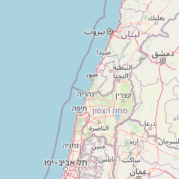
Map view of Tel Hazor National Park

Use this park location map to pinpoint Tel Hazor National Park in Israel, understand its exact geographic position, and read its mapped placement within the surrounding landscape more clearly.

Pigeon | © OpenStreetMap contributors

Visualizing the archaeological tells, strategic terrain, and unique protected environment of this significant Upper Galilee site.

Tel Hazor National Park Photos: Explore Ancient Landscapes and Protected Area Scenery

Browse a visual atlas of Tel Hazor National Park, revealing its distinct archaeological tell, surrounding Upper Galilee terrain, and the overall character of this ancient protected landscape. These images provide essential visual context for understanding the site's strategic location, excavated structures, and the environmental setting of this historically significant national park.

Archaeological ruins of the House of Pillars with standing stone columns at Tel Hazor National Park.

Stone ruins of an ancient archaeological site with scattered walls and foundations under a clear blue sky

Aerial photograph of Tel Hazor National Park showing archaeological ruins, a building, roads, and surrounding agricultural fields

Stone architectural structure with carved scroll designs displayed indoors

Ancient stone ruins of the Solomonic Gate at Tel Hazor National Park, with blue informational signs in the foreground and a modern shelter in the background

Park atlas

Trace the regional geography of protected landscapes, from the Upper Galilee to the surrounding ancient sites, for comparative exploration.

Explore National Parks and Protected Areas Near Tel Hazor National Park

After exploring Tel Hazor National Park, browse other national parks and protected areas across the Upper Galilee region and beyond. Comparing these diverse conservation landscapes provides valuable insights into regional geography, historical contexts, and broader protected area networks.
National parkNorthern District
About 12 km away#1 closest

South

Korazim National Park: Protected Landscape and Ancient Site Atlas in Northern District

Mapped basalt plateau and Galilean archaeological context.

Korazim National Park offers a unique exploration of protected landscape and ancient history on Israel's Korazim plateau. This national park preserves the archaeological site of Chorazin, a biblical-era town, set within an elevated volcanic terrain. The park's geography is defined by the basaltic geology characteristic of the eastern Galilee, providing wide views toward the Sea of Galilee and the surrounding regions. Understanding Korazim National Park involves appreciating its role as a protected area where natural terrain and historical preservation converge within the mapped geography of the Northern District.

Relief
Upland
Climate
Mediterranean
Scope
Terrestrial
Water
Major water bodies
National parkIsrael
About 15 km away#2 closest

West

Bar'am National Park: Preserving Ancient Jewish Heritage and Galilee Landscape

Explore significant Talmudic-era synagogues and borderland geography.

Bar'am National Park is an important archaeological site in Israel's upper Galilee, renowned for its remarkably preserved ancient Jewish synagogues dating to the Talmudic period. These structures represent significant tangible evidence of Jewish religious life and architectural styles from late antiquity. Situated amidst the rolling hills of the Galilee countryside, the park's landscape offers a unique combination of historical reflection and scenic views towards the Lebanese border, making it a key destination for understanding regional heritage and geography.

Relief
Upland
Access
Moderate access
Scope
Terrestrial
Water
No major water
National parkIsrael
About 23 km away#3 closest

South

Kursi National Park: National Park in Israel with Mapped Protected Landscape Context

Explore its geographic boundaries and regional protected area significance.

Kursi National Park stands as a distinct national park within Israel, offering a rich subject for geographic and atlas exploration. This entry focuses on its protected landscape identity, mapped contours, and its contribution to the country's conservation map. Delve into the specific geographic context and understand how Kursi National Park fits into the broader atlas of protected natural areas in the region.

Relief
Upland
Scope
Terrestrial
Water
Minor water
Watercolor painting with green, pink, yellow, and white areas depicting terrain and water
National parkIsrael
About 23 km away#4 closest

North

Hurshat Tal National Park: Ancient Valonia Oak Forest and Protected Landscape Identity

Explore mapped boundaries and geographic context in Israel's Hula Valley.

Hurshat Tal National Park is a protected area in northern Israel’s Hula Valley, distinguished by its extraordinary grove of ancient Valonia oak trees, some dating back 350 to 400 years. This site offers a rare look at a living forest heritage, serving a dual role as a crucial nature conservation zone and a popular family recreational destination with facilities like accommodation and swimming areas, making it a unique feature on any park atlas.

Area
0.765 km²
Established
1968
IUCN
V
Relief
Lowland
National parkIsrael
About 28 km away#5 closest

South

Hamat Tiberias National Park: Explore Protected Landscape and Mapped Geography in Israel

Discover natural terrain and park boundaries within Israel's protected areas.

Delve into Hamat Tiberias National Park, an important protected landscape in Israel. This page offers a detailed look at its geographic setting and the value it holds for atlas exploration. Understand the mapped extent of the park and its place within the regional geography, providing a concrete basis for understanding protected natural areas.

National parkGolan Heights
About 28 km away#6 closest

Northeast

Hermon National Park: National Park with Distinct Protected Landscape in Golan Heights

Explore its mapped boundaries and regional geographic context.

Hermon National Park is a designated national park contributing to the rich tapestry of protected landscapes within the Golan Heights. This entity offers a focused entry into understanding its specific geographic setting, mapped terrain, and its significance as a protected area. Users can explore the natural features and regional context that define Hermon National Park, enhancing their atlas-based discovery of Israel's conservation lands.

IUCN
V
Watercolor illustration of green mountains, a river, and trees with distant hills under a yellow sky
National parkIsrael
About 30 km away#7 closest

Northeast

Nimrod Fortress National Park: Protected Landscape and Geographic Context in Israel

Explore the mapped boundaries and natural terrain of this Israeli national park.

Nimrod Fortress National Park is a protected area in Israel offering a unique lens through which to explore its regional geography and landscape character. This atlas-focused presentation details the park's protected status and its place within the broader mapped terrain. Understand the significance of its geographic setting and the extent of its protected boundaries for landscape discovery.

Relief
Mountain
Access
Easy access
Scope
Terrestrial
Water
Minor water
National parkIsrael
About 32 km away#8 closest

West

Yehi'am Fortress National Park: National Park with Protected Landscape Identity in Israel

Discover its mapped geographic boundaries and regional landscape context.

Yehi'am Fortress National Park is a key protected area situated within the geographic landscape of Israel. This national park entry provides structured insights into its distinct natural features and its role as a mapped protected zone. Explore the regional context and unique geographic identity of Yehi'am Fortress National Park, contributing to a broader understanding of Israel's conservation landscapes.

Relief
Upland
Access
Moderate access
Scope
Terrestrial
Water
No major water

Common questions about visiting, size, designation, and location context for Tel Hazor National Park

Tel Hazor National Park FAQs for park facts, access, geography, and protected area context

Find quick answers about Tel Hazor National Park, including protected-area facts, park geography, trail and visitor context, and how the park fits into its surrounding country and regional landscape.
MoriAtlas Explorer

Continue Your Protected Areas Search Across the Global Atlas

Deepen your exploration by continuing the structured search for national parks and protected areas worldwide. Utilize the comprehensive filtering capabilities to compare different conservation landscapes and refine your understanding of global park geography. Discover more about the distribution and characteristics of protected natural areas.

Global natural geography