Mori Atlas logo
National parkYehi'am Fortress National Park

Discover the geographic identity and mapped boundaries of this protected national park in Israel.

Yehi'am Fortress National Park: Explore Israel's National Park and Protected Landscape

Yehi'am Fortress National Park represents a significant protected area within Israel's diverse geography. As a designated national park, it offers a distinct landscape setting for exploration and understanding its regional context. This page serves as a gateway to discovering the park's mapped boundaries, its place within the natural terrain of Israel, and the broader atlas of protected lands.

historical parksarchaeological sitesfortressesUpper Galilee Crusader heritageOttoman architecture

Yehi'am Fortress National Park

National park

Park overview

Structured park overview, official facts, and landscape profile for Yehi'am Fortress National Park

Yehi'am Fortress National Park park facts, protected area profile, and essential visitor context

Review the core facts for Yehi'am Fortress National Park, including designation, size, terrain, visitor scale, habitats, and operating context in one park-focused overview.

About Yehi'am Fortress National Park

Yehi'am Fortress National Park preserves a significant historical site in the Upper Galilee region of northern Israel. The park encompasses the ruins of a hilltop fortress that has been rebuilt and destroyed multiple times over the past eight centuries, creating a complex archaeological landscape with elements from different historical periods. The original Crusader-era structure was built by the Teutonic Order after 1220 and later destroyed by the Mamluk sultan Baibars between 1268 and 1271. The fortress was subsequently rebuilt and expanded in the 1760s by the Arab leader Zahir al-Umar, who constructed what became known as Qal'at Jiddin or Jiddin Castle. This reconstruction was short-lived, as the fortress was destroyed again around 1775 by Ahmed Jezzar Pasha, a powerful Ottoman governor. Following this final destruction, the ruins became known as Khirbat Jiddin, meaning "ruins of Jiddin," and were eventually inhabited by Bedouin tribes. The establishment of Kibbutz Yehi'am in 1946 brought new human activity to the area, and the fortress site was incorporated into Israel's national park system to preserve its historical and archaeological significance.

Quick facts and research context for Yehi'am Fortress National Park

Yehi'am Fortress National Park is located in western Upper Galilee, northern Israel, near Kibbutz Yehi'am. The park protects the ruins of a hilltop fortress with origins dating to the Crusader era when the Teutonic Order constructed Iudyn Castle after 1220. The structure was destroyed in the mid-13th century, rebuilt in the 1760s by Zahir al-Umar, and destroyed again around 1775 by Ahmed Jezzar Pasha. The site later became home to Bedouin tribes before the establishment of Kibbutz Yehi'am in 1946. The park contains several notable structures including a watch tower, mosque, and vaulted hall, along with archaeological remnants of Roman and Byzantine occupation.

Protection and recognition

Verifying terrestrial management scope and official regional protection framework data

Yehi'am Fortress National Park Protection Status and Conservation Profile

Historical conservation data outlines the terrestrial protection framework and official designation history for Yehi'am Fortress National Park. Comparing official boundary records and international status indicators helps researchers evaluate the park's place within global conservation networks.

Protection details

Protection scope
Terrestrial
Park context

Deeper park guide and search-rich context for Yehi'am Fortress National Park

Yehi'am Fortress National Park history, landscape, wildlife, and travel context

Explore Yehi'am Fortress National Park through its history, landscape character, ecosystems, wildlife, conservation priorities, cultural context, and seasonal travel timing in a structured park guide built for atlas discovery and search intent.

Why Yehi'am Fortress National Park stands out

Yehi'am Fortress is best known for its multi-layered historical architecture spanning the Crusader, Mamluk, and Ottoman periods. The fortress ruins represent one of the few surviving examples of Teutonic Order castle construction in Israel. The site is notable for its strategic hilltop location in Upper Galilee and the sequence of destruction and rebuilding that has shaped its current appearance. The combination of medieval fortress architecture with later Ottoman additions, along with visible trenches from the 1948 war, creates a distinctive historical palimpsest. Archaeological finds including a Roman fort, Byzantine monastery, and burial caves add further historical depth to the site.

Yehi'am Fortress National Park history and protected-area timeline

The history of Yehi'am Fortress spans over 800 years of continuous construction, destruction, and transformation. The original fortress, known as Iudyn Castle, was constructed by the Teutonic Order after 1220 during the Crusader period. This Teutonic Knights' castle was destroyed by the Mamluk sultan Baibars sometime between 1268 and 1271, ending the Crusader presence at the site. After lying in ruins for several centuries, the fortress was rebuilt and significantly expanded by Zahir al-Umar, a prominent Arab leader who controlled much of northern Israel in the mid-18th century. Under his direction between 1760 and 1769, the fortress became known as Qal'at Jiddin and served as a regional stronghold. However, the fortress was destroyed once again around 1775 by Ahmed Jezzar Pasha, an ambitious Ottoman pasha who sought to consolidate power in the region. The ruined site subsequently became a settlement for Bedouin tribes who inhabited the remains through the early-to-mid 20th century. In 1946, Kibbutz Yehi'am was established nearby, and following the 1948 War of Independence, the fortress site was integrated into Israel's national parks system. Trenches from the 1948 war remain visible around the castle area today, adding a modern layer to the site's historical significance.

Yehi'am Fortress National Park landscape and geographic character

Yehi'am Fortress National Park occupies a strategic hilltop position in western Upper Galilee, a region characterized by rolling hills, Mediterranean woodlands, and agricultural landscapes. The fortress sits at an elevation that provides both defensive advantages and panoramic views over the surrounding countryside. While the Wikipedia source provides limited detail about the specific geological and terrain features of the park area, the Upper Galilee region is generally known for its limestone formations, forested slopes, and proximity to the Mount Meron mountain range. The park's landscape combines the historical built environment with the natural terrain that has shaped the region's character. The combination of ruins and natural setting creates an environment where visitors can experience both human history and the Galilee landscape.

Yehi'am Fortress National Park ecosystems, habitats, and plant life

The Wikipedia source does not provide detailed information about the specific natural ecosystems, habitats, or biodiversity present within Yehi'am Fortress National Park. As a historical and archaeological park focused on preserving fortress ruins, the site appears to emphasize its built heritage and historical significance rather than ecological or natural features. The surrounding Upper Galilee region does contain diverse Mediterranean ecosystems, including oak forests, maquis vegetation, and seasonal wildflower displays, but the source material does not elaborate on these aspects specifically within the park boundaries. Visitors interested in natural history would need to consult additional sources for detailed ecological information about the park area.

Yehi'am Fortress National Park wildlife and species highlights

The source material does not include specific information about wildlife populations, animal species, or wildlife viewing opportunities at Yehi'am Fortress National Park. The park is primarily oriented toward historical and archaeological preservation rather than wildlife conservation or nature observation. While the Upper Galilee region generally supports diverse wildlife including various bird species, small mammals, and reptiles in its Mediterranean habitats, the Wikipedia source does not provide park-specific wildlife details. The absence of wildlife information in the source material makes it inappropriate to generate speculative content in this field.

Yehi'am Fortress National Park conservation status and protection priorities

Yehi'am Fortress National Park is protected as part of Israel's national park system, which maintains and preserves the country's significant historical and archaeological sites. The park serves a conservation function by protecting the ruins of a multi-period fortress that represents important historical layers from the Crusader, Mamluk, and Ottoman periods. The inclusion of the site within Israel's national parks reflects its significance as a cultural heritage resource requiring specialized preservation approaches. Archaeological remains at the site, including the Roman fort, Byzantine monastery, burial caves, and mosaic fragments, receive protection through the park's designation. Conservation efforts at the site must balance preservation of historical structures with public access and interpretation.

Yehi'am Fortress National Park cultural meaning and human context

Yehi'am Fortress sits within a region of significant cultural and historical importance in northern Israel. The kibbutz established adjacent to the fortress in 1946 represents a particular chapter in modern Israeli history, as kibbutzim were foundational to the country's early settlement patterns. The site's long history of occupation and destruction reflects the broader geopolitical dynamics of the Levant, with the fortress changing hands between Crusaders, Mamluks, Ottomans, and eventually becoming part of modern Israel. The Bedouin tribes who inhabited the ruins after the fortress's final destruction represent another layer of the region's cultural history. The presence of a mosque among the surviving structures indicates the site's role in later Islamic period occupation. The surrounding Upper Galilee has been home to diverse communities over millennia, and the fortress ruins serve as a physical reminder of this layered human history.

Top sights and standout views in Yehi'am Fortress National Park

The primary highlight of Yehi'am Fortress National Park is the opportunity to explore ruins spanning more than eight centuries of history in one location. Visitors can examine the remains of a Crusader-era fortress built by the Teutonic Order, later rebuilt and expanded during the Ottoman period. The surviving structures include a watch tower with lookout platform offering views over the Galilee landscape, a historic mosque, and a large vaulted hall. The archaeological complexity of the site is noteworthy, with remains from Roman, Byzantine, and later periods visible throughout the park. The trenches from the 1948 War of Independence provide a modern historical connection to Israel's formative period. The park offers a relatively uncrowded alternative to more famous Israeli historical sites, allowing visitors to experience the ruins in a more contemplative setting.

Best time to visit Yehi'am Fortress National Park

The best time to visit Yehi'am Fortress National Park would likely align with Israel's general comfortable touring seasons, which are spring and autumn when temperatures are moderate and conditions are suitable for exploring outdoor historical sites. The summer months in Upper Galilee can bring high temperatures that may make extensive walking around the ruins less comfortable, while winter rains can occasionally affect access. As a park focused on historical ruins rather than natural phenomena, seasonal variations in the visiting experience may be less pronounced than at parks with strong seasonal natural features. Visitors interested in combining the fortress visit with broader Upper Galilee exploration may find spring and autumn particularly suitable for touring the region.

Monthly climate preview

Analyzing long-term monthly temperature averages and precipitation cycles within Israel

Weather by Month and Climate Normals for Yehi'am Fortress National Park

Measured at an elevation of 104 meters, Yehi'am Fortress National Park exhibits warm, dry summers peaking at over 26 degrees Celsius alongside wetter, milder winter periods. Exploring the complete twelve-month database provides detailed daily precipitation rates, historic average minimums, and seasonal variations to clarify the regional climate profile.
Annual mean20 °C
14 °C27 °C
Jan14°
Feb14°
Mar15°
Apr17°
May21°
Jun24°
Jul26°
Aug27°
Sep26°
Oct24°
Nov20°
Dec16°
Warmest month
August

26.7 °C

Coolest month
January

13.7 °C

Wettest month
January

4.4 mm/day

Driest month
August

0.1 mm/day

Park location guide

Geography guide, regional context, and park location map for Yehi'am Fortress National Park

Yehi'am Fortress National Park park geography, regions, and map view in Israel

Understand where Yehi'am Fortress National Park sits in Israel through a broader geographic reading of the surrounding landscape, nearby location context, and its mapped position within the national park landscape.

How Yehi'am Fortress National Park fits into Israel

Israel is a parliamentary republic in the Southern Levant, established in 1948 as a Jewish homeland. It borders Lebanon, Syria, Jordan, and Egypt, with Mediterranean coastline and access to the Red Sea. Jerusalem is the capital, though its status is contested, while Tel Aviv is the largest urban area. The country has a high-income economy with strong technology and innovation sectors.

Wider geography shaping Yehi'am Fortress National Park in Israel

Israel occupies the Southern Levant region of West Asia. It is bordered by Lebanon to the north, Syria to the northeast, Jordan to the east, and Egypt to the southwest. The western coast lies on the Mediterranean Sea, while the southern tip reaches the Red Sea. The eastern border includes the Dead Sea, Earth's lowest point. The country occupies the West Bank, Gaza Strip, and Golan Heights.

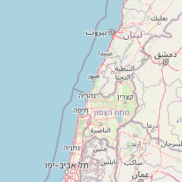
Map view of Yehi'am Fortress National Park

Use this park location map to pinpoint Yehi'am Fortress National Park in Israel, understand its exact geographic position, and read its mapped placement within the surrounding landscape more clearly.

Pigeon | © OpenStreetMap contributors
Park atlas

Explore the Diverse Protected Landscapes and Archaeological Sites Across the Northern District of Israel

Discover Other National Parks and Protected Areas Near Yehi'am Fortress National Park

Browse national parks, historical sites, and other protected areas near Yehi'am Fortress National Park, tracing connected landscapes and cultural heritage across the Upper Galilee region. Compare geographic features and conservation efforts across adjacent protected areas, providing deeper context for regional landscapes and their shared historical significance.
National parkIsrael
About 19 km away#1 closest

East

Bar'am National Park: Preserving Ancient Jewish Heritage and Galilee Landscape

Explore significant Talmudic-era synagogues and borderland geography.

Bar'am National Park is an important archaeological site in Israel's upper Galilee, renowned for its remarkably preserved ancient Jewish synagogues dating to the Talmudic period. These structures represent significant tangible evidence of Jewish religious life and architectural styles from late antiquity. Situated amidst the rolling hills of the Galilee countryside, the park's landscape offers a unique combination of historical reflection and scenic views towards the Lebanese border, making it a key destination for understanding regional heritage and geography.

Relief
Upland
Access
Moderate access
Scope
Terrestrial
Water
No major water
National parkIsrael
About 28 km away#2 closest

South

Zippori National Park: Explore Israel's Protected Landscape and Roman Period History

Mapped geography and protected terrain in the heart of the Levant.

Zippori National Park presents a fascinating protected landscape within Israel, offering insights into its historic terrain and geographic context. As a designated national park, its mapped boundaries delineate an area significant for its archaeological sites, particularly those from the Roman period. This entry provides structured information on the park's protected status and its place within the broader atlas of the Levant, emphasizing discovery through its landscape and historical geography.

IUCN
V
Scope
Terrestrial
Nature reserveLebanon
About 28 km away#3 closest

North

Tyre Coast Nature Reserve: Lebanon's Protected Nature Reserve Geography and Atlas Mapping

Discover the mapped natural landscape and regional context.

Tyre Coast Nature Reserve represents a distinct protected area within Lebanon, offering a unique focus for geographic exploration. This entry provides detailed insights into its mapped boundaries, situating it within the broader natural landscape and regional geography of the country. Engage with the structured atlas data to understand the specific protected land identity and geographic characteristics of this nature reserve.

Area
3.8 km²
Established
1998
Relief
Lowland
Climate
Mediterranean
National parkIsrael
About 30 km away#4 closest

Southwest

Mount Carmel National Park: Explore Israel's Protected Landscape and Geographic Atlas

Discover the mapped boundaries and natural terrain.

Mount Carmel National Park serves as a critical point for understanding protected areas and regional geography within Israel. This national park offers a detailed view of its specific landscape, mapped terrain, and protected boundaries, making it an essential component of any geographic exploration focused on the Levant. Investigate the park's unique features to enhance your understanding of conservation landscapes and their mapping within the Middle East.

Area
100 km²
Established
1960
Relief
Mountain
Climate
Mediterranean
National parkNorthern District
About 32 km away#5 closest

East

Korazim National Park: Protected Landscape and Ancient Site Atlas in Northern District

Mapped basalt plateau and Galilean archaeological context.

Korazim National Park offers a unique exploration of protected landscape and ancient history on Israel's Korazim plateau. This national park preserves the archaeological site of Chorazin, a biblical-era town, set within an elevated volcanic terrain. The park's geography is defined by the basaltic geology characteristic of the eastern Galilee, providing wide views toward the Sea of Galilee and the surrounding regions. Understanding Korazim National Park involves appreciating its role as a protected area where natural terrain and historical preservation converge within the mapped geography of the Northern District.

Relief
Upland
Climate
Mediterranean
Scope
Terrestrial
Water
Major water bodies
National parkIsrael
About 32 km away#6 closest

East

Tel Hazor National Park: Protected Landscape Details and Geographic Atlas Context

Explore the mapped boundaries and regional character of this Israeli national park.

Tel Hazor National Park is a protected national park entity situated within the geography of Israel. This page provides detailed information on its protected landscape, emphasizing its mapped boundaries and contribution to regional natural landscape context. Discover the geographic identity of Tel Hazor National Park and its significance for atlas exploration of protected areas in the Levant.

Relief
Upland
Scope
Mixed
Water
Minor water
Watercolor illustration showing a landscape with green trees, a winding river, and distant mountains under a light sky
National parkIsrael
About 34 km away#7 closest

South

Beit She'arim National Park: Historic Jewish Necropolis and Limestone Landscape Atlas

Discover the protected geography of ancient burial sites in Israel.

Beit She'arim National Park offers a detailed exploration of a significant ancient Jewish necropolis carved into the soft limestone hills of Israel's Lower Galilee. This protected area preserves remarkable burial caves, catacombs, and sarcophagi adorned with intricate carvings and inscriptions from antiquity. As a UNESCO World Heritage Site, it stands as a landmark of Jewish historical and cultural continuity, providing invaluable insights into the region's past inhabitants and their traditions through its unique archaeological landscape.

IUCN
V
Relief
Upland
Climate
Mediterranean
Access
Moderate access
National parkIsrael
About 39 km away#8 closest

Southeast

Hamat Tiberias National Park: Explore Protected Landscape and Mapped Geography in Israel

Discover natural terrain and park boundaries within Israel's protected areas.

Delve into Hamat Tiberias National Park, an important protected landscape in Israel. This page offers a detailed look at its geographic setting and the value it holds for atlas exploration. Understand the mapped extent of the park and its place within the regional geography, providing a concrete basis for understanding protected natural areas.

Common questions about visiting, size, designation, and location context for Yehi'am Fortress National Park

Yehi'am Fortress National Park FAQs for park facts, access, geography, and protected area context

Find quick answers about Yehi'am Fortress National Park, including protected-area facts, park geography, trail and visitor context, and how the park fits into its surrounding country and regional landscape.
MoriAtlas Explorer

Continue Your Protected Areas Search Across the Global Atlas

Deepen your exploration by continuing the structured search for national parks and protected areas worldwide. Utilize the comprehensive filtering capabilities to compare different conservation landscapes and refine your understanding of global park geography. Discover more about the distribution and characteristics of protected natural areas.

Global natural geography